Graphical Abstract
JMSJ, 2017, Vol. 95, No. 1 (February)
Review Articles
Kitoh (2017)
Kitoh, A., 2017: The Asian monsoon and its future change in climate models: A review. J. Meteor. Soc. Japan, 95, 7-33.
https://doi.org/10.2151/jmsj.2017-002
Graphical Abstract
Highlights:
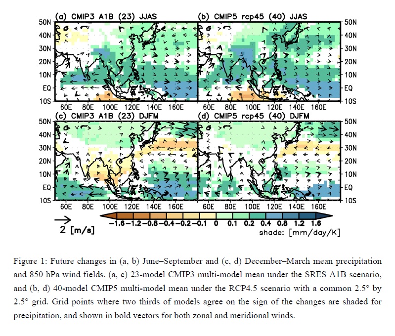
- An overview of the Asian monsoon and its change as simulated by AOGCMs and high-resolution AGCMs, focusing on the seasonal mean circulation and precipitation climatology. It consists of "Elements that affect the monsoon", "The monsoon in the historical period", and "Future projections of monsoons".
- Overall projections are similar for both CMIP3 and CMIP5 models, with increases in precipitation, albeit with weakened circulations in the South Asian summer, enhanced circulations and increased precipitation in the East Asian summer, and latitude–dependent changes in the winter monsoon circulation in East Asia. However, differences exist in the projected local changes, leading to uncertainty in projections.
Articles
Yoshida et al. (2017)
Yoshida, R., Y. Miyamoto, H. Tomita, and Y. Kajikawa, 2017: The effect of water vapor on tropical cyclone genesis: A numerical experiment of a non-developing disturbance observed in PALAU2010. J. Meteor. Soc. Japan, 95, 35-47.
https://doi.org/10.2151/jmsj.2017-001
Graphical Abstract
Highlights:
- The environmental conditions for tropical cyclone genesis is examined by numerical experiment. We clarify the importance of abundant moisture around the disturbance for continuous convection and demonstrate that the collocation of a mid-level vortex and a low-level vortex, i.e., the persistence of an upright structure of vortices, is important in tropical cyclone genesis.
- The experiment based on reanalysis data, the disturbance did not develop into a tropical cyclone in spite of the existence of the mid-level and low-level vortices (Fig. 1).
- In the experiment with increased water vapor content, a tropical cyclone was formed from the disturbance. The presence of persistent upright vortices was supported by continuous convection until genesis of tropical cyclone (Fig. 2).
Suwarman et al. (2017)
Suwarman, R., K. Ichiyanagi, M. Tanoue, K. Yoshimura, S. Mori, M. D. Yamanaka, F. Syamsudin, and H. A. Belgaman, 2017: El Niño Southern Oscillation signature in atmospheric
water isotopes over Maritime Continent during wet season. J. Meteor. Soc. Japan, 95, 49-66.
https://doi.org/10.2151/jmsj.2017-003
Graphical Abstract
Special Edition on Contributions to Asia Oceania Atmospheric Sciences
Highlights:
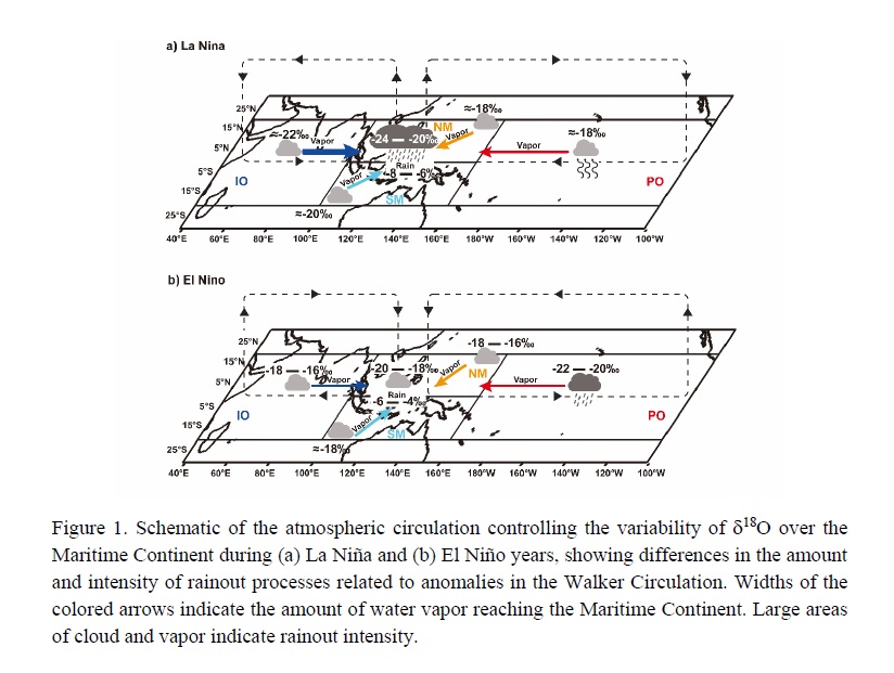
- The study shows the response of stable isotopes in precipitation to ENSO events and the spatial distribution of water sources from a particular region in order to understand how water vapor from a particular region might influence the isotopic variability due to ENSO using a simulated isotopic model (Figure 1).
- In addition, we propose several plausible factors that control the isotopic variation during ENSO. In General, the depletion and enrichment of stable isotopes correspond to the appearance of zones of convergence and divergence over the Maritime Continent during La Niña and El Niño, respectively.
- An asymmetric ENSO feature is found in this study, evidenced by the similar contributions of water source quantity from the northern Maritime Continent and the Pacific Ocean during both ENSO phases.
JMSJ, 2017, Vol. 95, No. 2 (April)
Articles
Kawai et al. (2017)
Kawai, Y., Q. Moteki, A. Kuwano-Yoshida, T. Enomoto, A. Manda, and H. Nakamura, 2017: Impact propagation of radiosonde data assimilation over the Kuroshio and Kuroshio Extension: Case study on the early summer (Baiu) in 2012. J. Meteor. Soc. Japan, 95, 71-90.
https://doi.org/10.2151/jmsj.2017-004
Graphical Abstract
Highlights:
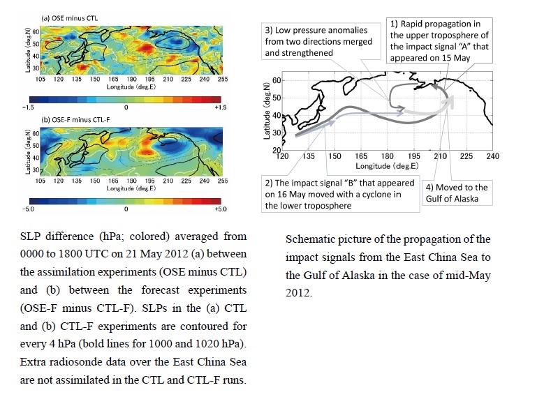
- In order to investigate how perturbations caused over the Kuroshio or Kuroshio Extension (KE) grow and propagate across the North Pacific Ocean, the authors performed observing system experiments using two extra sets of radiosonde data obtained over the East China Sea (ECS) in mid-May and over the KE in early July.
- The impact of the extra data assimilated propagated eastward mainly due to the advection by the subtropical jet, and led to reinforcement of a cyclone over the Gulf of Alaska in mid-May.
- In the case of mid-May, the impact signal that emerged over the ECS on 15 May quickly propagated eastward in the upper troposphere. Another impact signal that appeared in the lower troposphere on 16 May travelled eastward and merged with the preceding one, which resulted in the reinforcement of the cyclone.
Tochimoto et al. (2017)
Tochimoto, E., and T. Kawano, 2017: Numerical investigation of development processes of Baiu frontal depressions. Part I : Case studies. J. Meteor. Soc. Japan, 95, 91-109.
https://doi.org/10.2151/jmsj.2017-005
Graphical Abstract
Highlights:
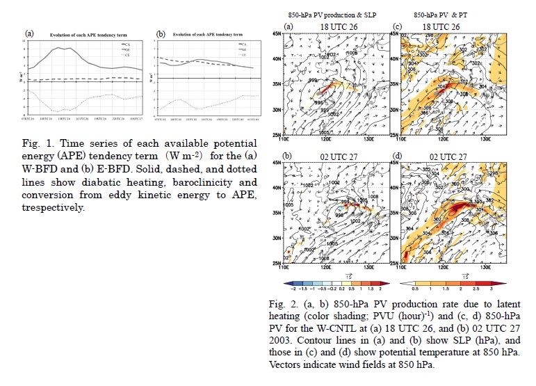
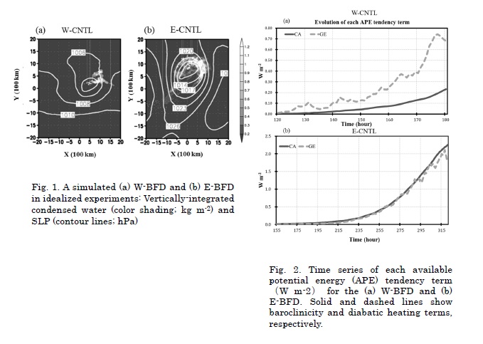
- This work investigates development processes of Baiu frontal depressions (BFDs) using WRF model. Two typical cases were selected from BFDs that appeared in June and July, 2000-2007: a BFD that developed in the western part of the Baiu frontal zone (W-BFD) and a BFD that had formed in the eastern part of the Baiu frontal zone (E-BFD).
- The effect of latent heating is dominant during the W-BFD development, while baroclinicity as well as latent heating is important to the E-BFD development.
- The W-BFD has a development mechanism driven by latent heating. In the early developmental stage, PV near the W-BFD center is enhanced. This feature is consistent with the nonlinear conditional instability of the second kind mechanism. In the later developmental stage, PV is produced in front of the W-BFD center, in which low-level baroclinicity is large. This process is consistent with a diabatic Rossby vortex.
Zhao (2017)
Zhao, Y., D. Wang, Z. Liang, and J. Xu, 2017: On the dynamics of the large-scale circulation during the persistent severe rainfall events in southern China. J. Meteor. Soc. Japan, 95, 111-125.
https://doi.org/10.2151/jmsj.2017-006
Graphical Abstract
Highlights:
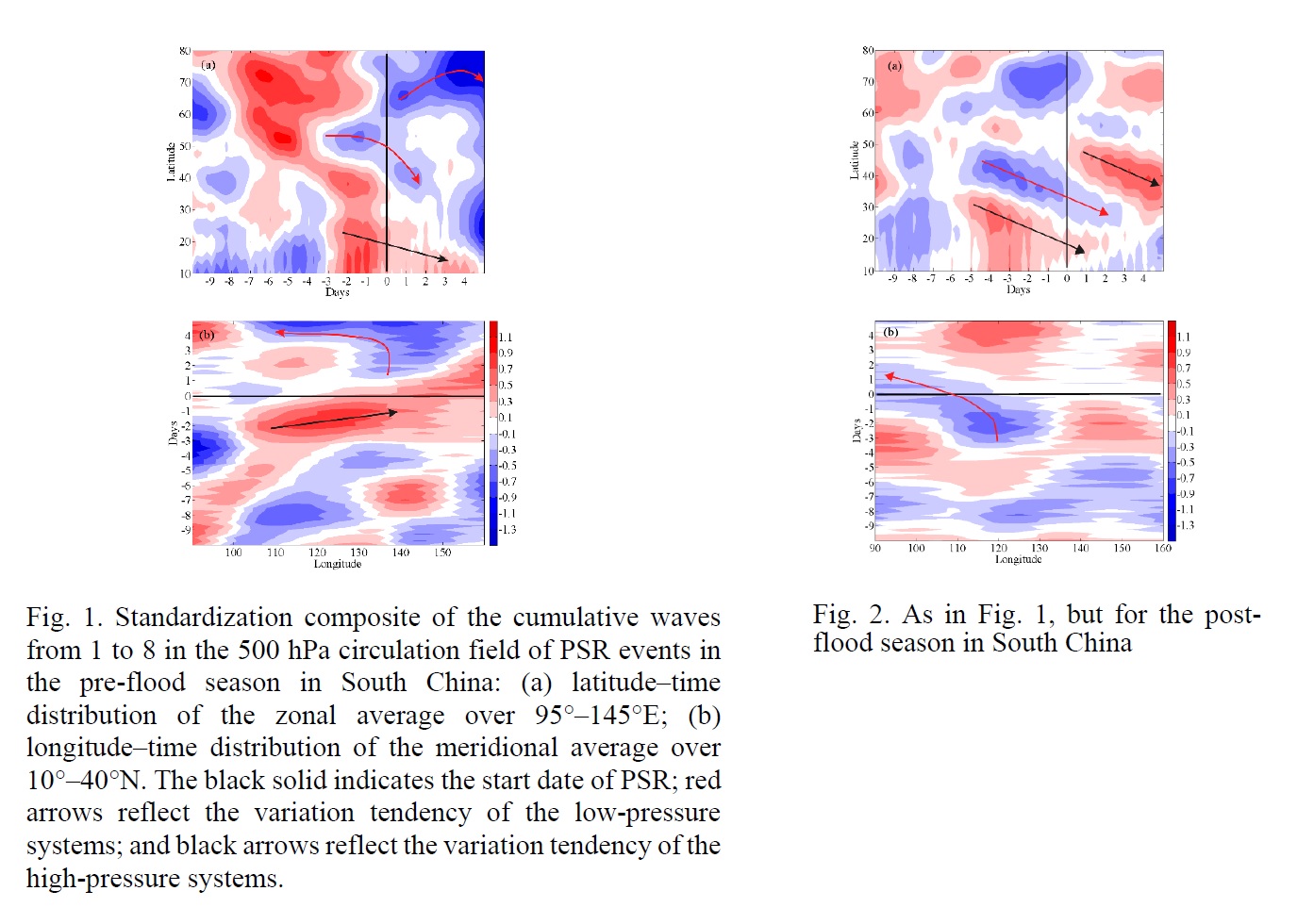
- The study shows the dynamic features of the large-scale circulation for persistent severe rainfall (PSR) events during the rainy season (April to July) in southern China. The aim of the study was to understand the formation mechanism and improve forecasting. The circulation field and spatiotemporal distribution of waves at 500 hPa for different types of PSR were analyzed.
- During the pre-flood season (April to June) in southern China, troughs have the same phase in the middle latitudes as those in the high latitudes. The East Asia major trough (3–5 wave numbers) in the middle latitudes strengthens southwards and interacts with the 30°N subtropical high (1–2 wave numbers) from three days prior to the PSR events (Figure 1).
- During the post-flood season (June to July) in South China, the weather regime transitions occur on five days prior to the PSR events. The 40°N trough (2–4 wave numbers) strengthens southwards and interacts with the subtropical high (1–2 wave numbers). It is also affected by the blocking ridge (3 wave number) in the high latitudes (Figure 2).
- During the Mei-yu period (June to July) over the Yangtze–Huaihe River basin, the transitions of circulation pattern start three days prior to the PSR events. With the northwest development of the subtropical high, there is a transfer process from long to short waves in terms of energy for the trough at 50°N.
Ninomiya (2017)
Ninomiya, K., 2017: A polar mesoscale cyclone formed over the East China Sea and developed into a secondary cyclone over the Northwestern Pacific: An observational case study on 19-22
February 1975. J. Meteor. Soc. Japan, 95, 127-145.
https://doi.org/10.2151/jmsj.2017-007
Graphical Abstract
Highlights:
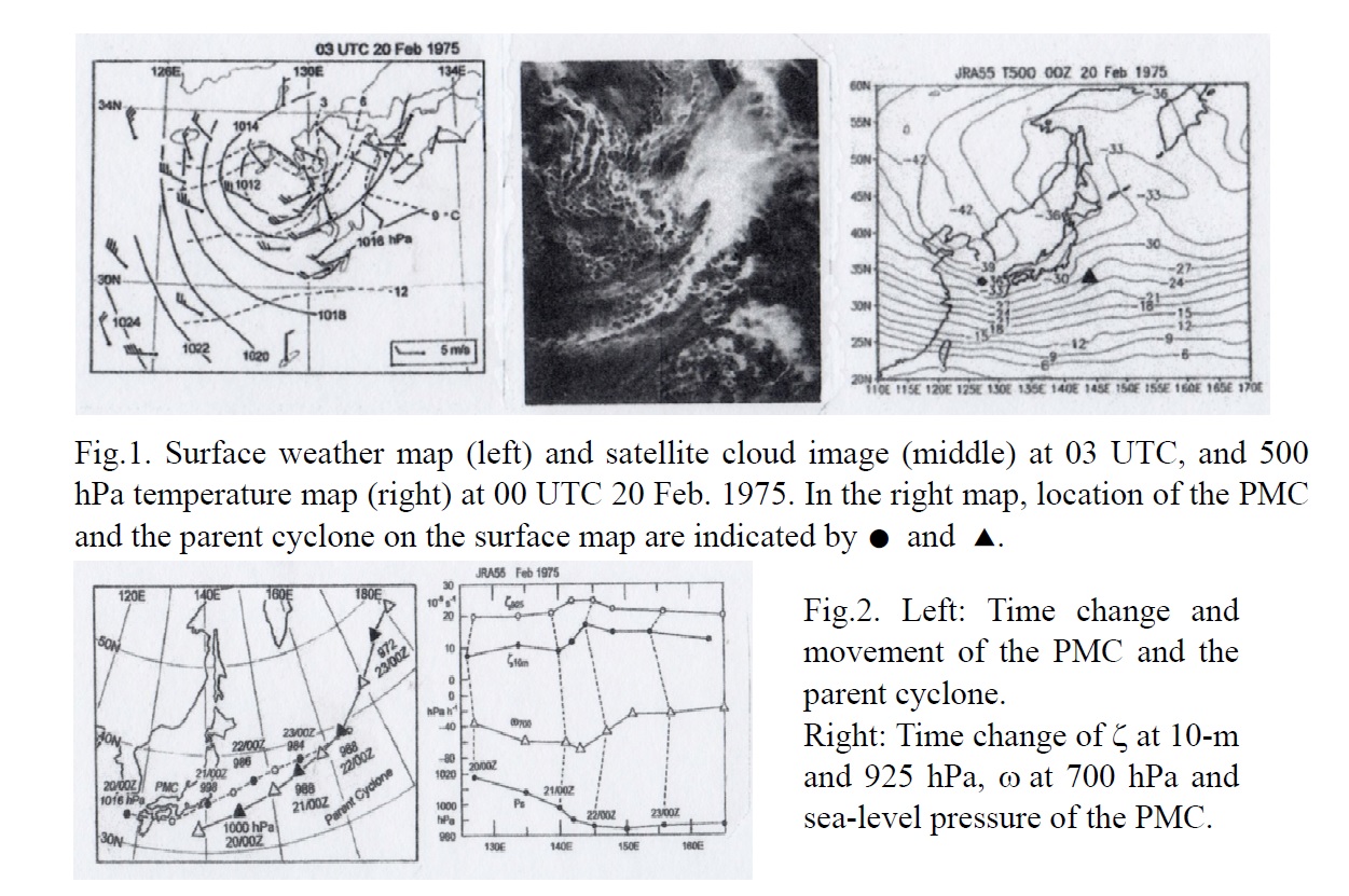
- Genesis of a polar mesoscale cyclone (PMC) over the East China Sea is studied using dense observation data, satellite cloud images and JRA-55 reanalysis data.
- PMCs frequently developed over the Japan Sea. Genesis of PMCs over the East China Sea is rare, but could occur under the certain synoptic-scale conditions.
- The PMC with comma-cloud formed within cyclonic polar-air streams induced by its synoptic-scale parent cyclone which developed near Japan. Within 3-hour after generation of the PMC, its central pressure deepened from 1016 hPa (at 00 UTC) to 1012 hPa (at 03 UTC). Strong surface winds occurred in the trail of the comma-cloud (Fig.1, left and middle).
- The large-scale condition for the generation stage was characterized by the southward intruding of the cold core in the upper cold trough beyond 34°N to the eastern East China Sea (Fig. 1, right), where the moist-neutral layer formed over the warm Tsushima Current.
- The PMC, after passing over Kyushu, developed as it moved eastward along the Pacific coast of Japan. It developed further in the low-level baroclinic zone over the Northwestern Pacific, into the secondary cyclone comparable to the parent cyclone (Fig.2). The large-scale conditions for the development were characterized by the upper cold trough and the low-level baroclinic zone formed over the zone of maximum sea-surface temperature gradient along north of the Kuroshio extension.
Li et al. (2017)
Li, Y., P. L. Ye, J. Feng, Y. Lu, J. H. Wang, and Z. X. Pu, 2017: Simulation and projection of blocking highs in key regions of the Eurasia by CMIP5 models. J. Meteor. Soc. Japan, 95, 147-165.
https://doi.org/10.2151/jmsj.2017-008
Graphical Abstract
Highlights:
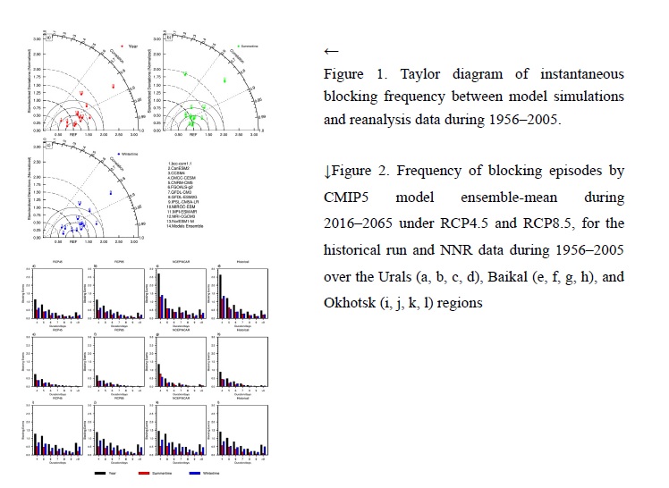
- Taylor diagrams are used to quantify the correspondence between modeled and observed instantaneous blocking frequency in Eurasia (Fig. 1), revealing that most of the CMIP5 models simulate instantaneous blocking frequency better in wintertime than in summertime.
- Blocking episode frequency is underestimated by most of the 13 CMIP5 models in the Urals and Baikal regions, especially for short-duration blocking episodes (4–5 days). The simulations are superior in wintertime in the Urals and Baikal regions. Modeled blocking episode frequency is close to the observed value in summertime but overestimated in wintertime in Okhotsk. The possible cause for the unsatisfying performance of the models is investigated, and it is shown that the five models that are better at simulating blocking may be superior because of their resolution and prior ability to simulate ENSO.
- The multi-model ensemble mean frequency of blocking episodes clearly decreases in the whole year in the Urals and Baikal regions (especially blocking episodes with short duration) and increases a little in summertime of the Okhotsk region in the first half of the 21st century. The model ensemble-mean frequency of blocking episodes with long duration (more than 9 days) decreases by ∼40% in the Urals region but increases by no more than 5% in Okhotsk (Fig. 2).
JMSJ, 2017, Vol. 95, No. 3 (June)
Articles
Kuroda et al. (2017)
Kuroda, Y., and K. Kodera, 2017: A simple multivariable maximum covariance analysis method. J. Meteor. Soc. Japan, 95, 171-180.
https://doi.org/10.2151/jmsj.2017-009
Graphical Abstract
Highlights:
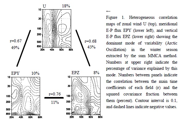
- A new simple method of multivariable maximum covariance analysis (MMCA) for extracting common variability from multiple (more than two) datasets, that expands the singular value decomposition analysis method, is proposed. Two approaches of the method are proposed, one using the extreme of a summation of covariances (sum MMCA) and the other using the product of covariances (product MMCA).
- Both approaches are demonstrated by successfully extracting the variability related to the Arctic Oscillation from three monthly-mean meteorological datasets (e.g., Fig. 1).
- The method is useful because it is easily programmed and is computationally inexpensive.
Zhao et al. (2017)
Zhao, Y., W. Mao, K. Zhang, Y. Ma, H. Li, and W. Zhang, 2017: Climatic variations in the boundary layer height of arid and semiarid areas in East Asia and North Africa. J. Meteor. Soc. Japan, 95, 181-197.
https://doi.org/10.2151/jmsj.2017-010
Graphical Abstract
Highlights:
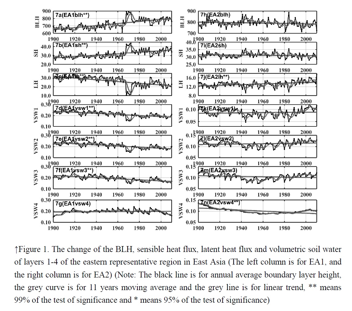
- From 1900 to 2010, in arid and semiarid area over East Asia, the BLH of the western areas had a decreasing trend, and the east had a rising trend (Fig. 1). While in arid and semiarid areas in North Africa, the BLH of the areas had a rising trend and other regions had a decreasing trend.
- On the spatial distribution, the BLH, sensible heat flux, latent heat flux and volumetric soil water had a good corresponding relationship.
- On the temporal change, in East Asia, the BLH had a stronger correlation with the thermodynamic factors than the dynamic factors (Fig. 1), while in the North Africa, the BLH had a stronger correlation with the dynamic factors. Besides, the upper level stratification also has some influence on the BLH’s change.
Wang et al. (2017)
Wang, J., and C. Li, 2017: Low-frequency variability and possible changes in the North Pacific simulated by CMIP5 models. J. Meteor. Soc. Japan, 95, 199-211.
https://doi.org/10.2151/jmsj.2017-011
Graphical Abstract
Highlights:
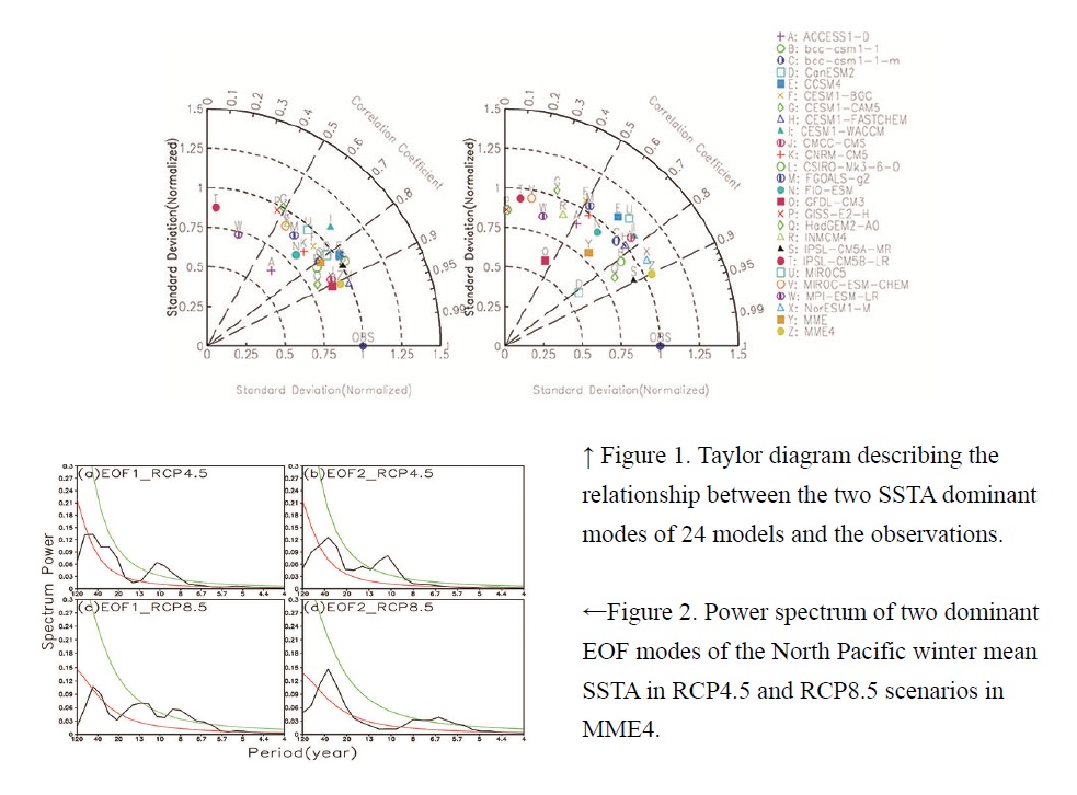
- Two dominant low-frequency modes in the North Pacific simulated by 24 CMIP5 models are evaluated, 24 CMIP5 models are generally capable of simulating the spatial patterns of PDO and NPGO with a strong inter-model spread (Fig.1). In addition, the performance of the air–sea coupling relationship of each mode is model dependent. Most of the models fail to simulate the air–sea coupling relationship of the second mode. Four models with better simulation capability both of the SSTA variability and the air–sea coupling relationship are selected (MME4).
- MME4 shows some progress in simulating the spatial and temporal characteristics of PDO and NPGO compared with most of the individual models, especially the period features. In future scenarios, spatial patterns of PDO and NPGO are substantially consistent, temporal patterns of PDO and NPGO change substantially. Both modes are weakened and shifted to a higher frequency in the RCP4.5 and RCP8.5 scenarios (Fig.2).
JMSJ, 2017, Vol. 95, No. 4 (August)
Articles
Tochimoto et al. (2017)
Tochimoto, E., and T. Kawano, 2017: Numerical investigation of development processes of Baiu frontal depressions. Part Ⅱ: An idealized study. J. Meteor. Soc. Japan, 95, 217-237.
https://doi.org/10.2151/jmsj.2017-012
Graphical Abstract
Highlights:
- To obtain generalized perspective of the development processes of BFDs in the western part of the Baiu frontal zone (W-BFDs) and those in the eastern part of the zone (E-BFDs), idealized numerical simulations with zonally homogeneous basic fields are conducted.
- The idealized simulations successfully reproduce a realistic W-BFD and E-BFD. The W-BFD has a slightly westward-tilted vertical structure, which is modulated by latent heating at low levels of the atmosphere. In contrast, the E-BFD has a westward-tilted structure through the troposphere, which is similar to the well-known baroclinic wave structure.
- The W-BFD has a mechanism mainly driven by latent heating yielding strong convection, while the E-BFD develops through baroclinic instability in moist atmosphere.
Okada et al. (2017)
Okada, Y., T. Takemi, H. Ishikawa, S. Kusunoki, and R. Mizuta, 2017: Future changes in atmospheric conditions for the seasonal evolution of the Baiu as revealed from projected
AGCM experiments. J. Meteor. Soc. Japan, 95, 239-260.
https://doi.org/10.2151/jmsj.2017-013
Graphical Abstract
Highlights:
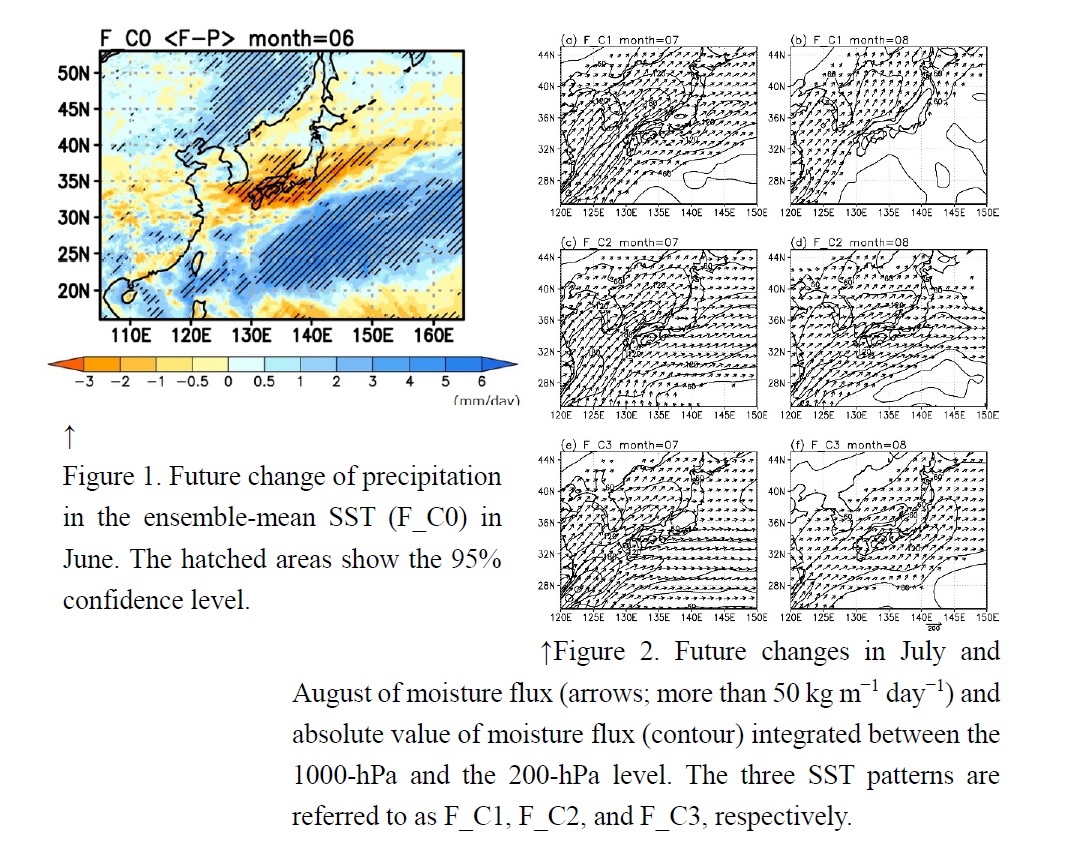
- Future changes in atmospheric circulation during the Baiu in Japan are investigated using 20-km-mesh atmospheric general circulation model (AGCM) simulations.
- All four SST patterns in the future climate under the RCP8.5 scenario show that the Baiu frontal zone is projected to stay to the south of Japan in June. Thus, precipitation is the projected to increase over this region, while decreasing in the western part of Japan (Fig.1).
- Precipitation and atmospheric circulation in July and August in the future climate simulation depend on the SST patterns (Fig.2). The difference in the SST pattern leads to a variation in sea-level pressure in the western North Pacific and affects the transport of water vapor to the surroundings of the Japanese islands during these periods.
Oigawa et al. (2017)
Oigawa, M., T. Matsuda, T. Tsuda, and Noersomadi, 2017: Coordinated observation and numerical study on a diurnal cycle of tropical convection over a complex topography in West Java, Indonesia. J. Meteor. Soc. Japan, 95, 261-281.
https://doi.org/10.2151/jmsj.2017-015
Graphical Abstract
Highlights:
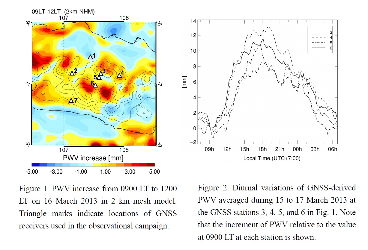
- Mechanisms related to the diurnal cycle of tropical deep convection over a complex terrain were investigated. Observational data was analyzed from X-band radar, Global Navigation Satellite System (GNSS) receivers, and radiosondes, with high-resolution numerical model data.
- A 2 km mesh model successfully simulated the observed diurnal variations of Precipitable Water Vapor (PWV) and rainfall, from 15 to 17 March 2013. In the model, moist air was present in the bottom of the basin during the early morning, which was transported to the southern slope of the basin by valley wind circulation after sunrise (Fig. 1). The valley wind decreased static stability around the southern slope of the basin by transporting moisture. The GNSS receiver network also recorded this simulated water vapor variability associated with the valley wind (Fig. 2).
- These results suggest that water vapor in the bottom of the basin during the morning, and its advection by valley wind, strongly influences convective initiation in Bandung.
JMSJ, 2017, Vol. 95, No. 5 (October)
Articles
Wang et al. (2017)
Wang, S., Y. Ding, F. Jiang, M. N. Anjum, and M. Iqbal, 2017: Defining indices for the extreme snowfall events and analyzing their trends in Northern Xinjiang, China. J. Meteor. Soc. Japan, 95, 287-299.
https://doi.org/10.2151/jmsj.2017-016
Ishii et al. (2017)
Ishii, S., P. Baron, M. Aoki, K. Mizutani, M. Yasui, S. Ochiai, A. Sato, Y. Satoh, T. Kubota, D. Sakaizawa, R. Oki, K. Okamoto, T. Ishibashi, T. Y. Tanaka, T. T. Sekiyama, T. Maki, K. Yamashita, T. Nishizawa, M. Satoh, and T. Iwasaki, 2017: Feasibility study for future space-borne coherent
Doppler wind lidar. Part 1: Instrumental overview for global wind profile observation. J. Meteor. Soc. Japan, 95, 301-317.
https://doi.org/10.2151/jmsj.2017-017
Graphical Abstract
Highlights:
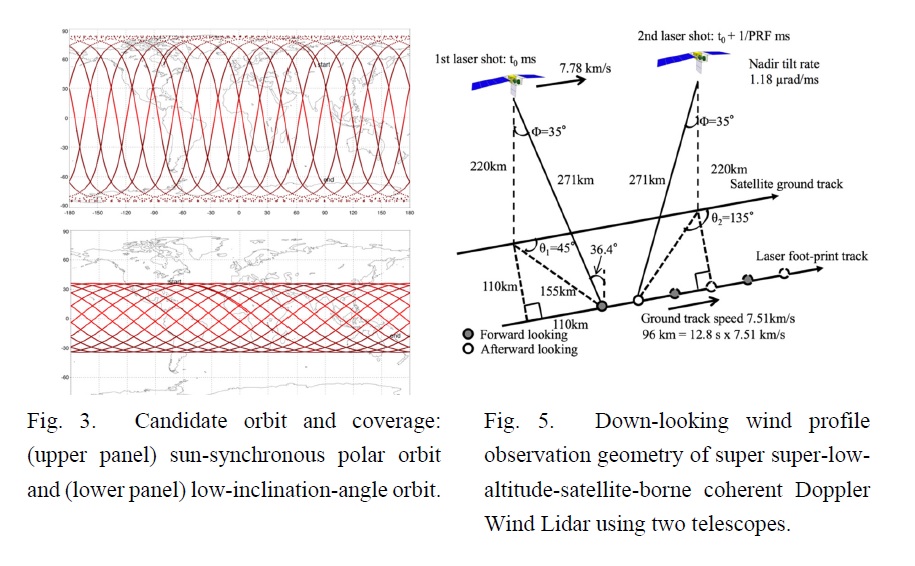
- Japanese working group is studying the feasibility of a future space-borne 2-μm coherent Doppler wind lidar (CDWL) for global wind profile observation. The paper describes the future space-borne CDWL in terms of technical points and observation user requirements.
- The future mission concept is designed to look at two locations at a nadir angle of 35° at two azimuth angles of 45° and 135° (225° and 305°) along the satellite track for vector wind measurement with vertical resolutions of 0.5 (lower troposphere: 0-3 km), 1(middle troposphere: 3-8 km), and 2 km (upper troposphere: 8-20 km) and horizontal resolution of <100 km along a satellite. The candidate altitude and orbit of the satellite are 220 km and an inclination angle of 96.4° (polar orbit) or 35.1° (low-inclination-angle orbit), respectively.
- The future space-borne CDWL wind profile observation will fill the gap of the current global wind observing systems and contribute to the improvement of the initial conditions for NWP, the prediction of typhoons and heavy rain, and various meteorological studies.
Baron et al. (2017)
Baron, P., S. Ishii, K. Okamoto, K. Gamo, K. Mizutani, C. Takahashi, T. Itabe, T. Iwasaki, T. Kubota, T. Maki, R. Oki, S. Ochiai, D. Sakaizawa, M. Satoh, Y. Satoh, T. Y. Tanaka, and M. Yasui, 2017: Feasibility study for future spaceborne coherent Doppler Wind Lidar. Part 2: Measurement
simulation algorithms and retrieval error characterization. J. Meteor. Soc. Japan, 95, 319-342.
https://doi.org/10.2151/jmsj.2017-018
Graphical Abstract
Highlights:
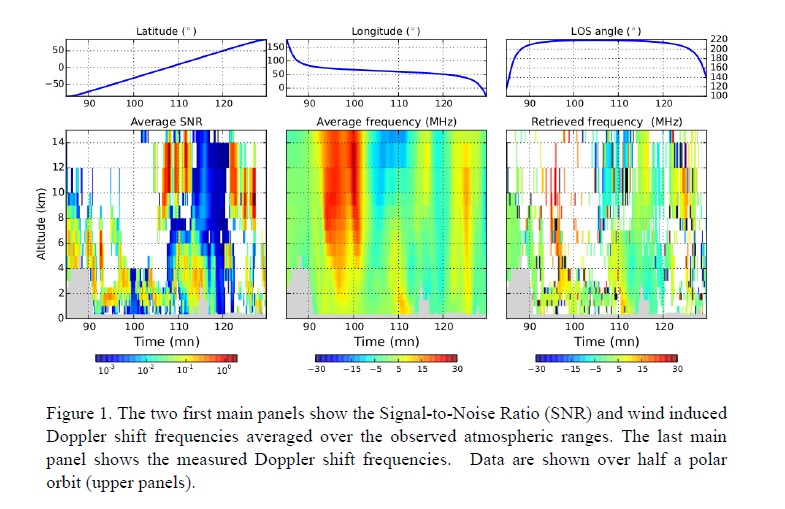
- A feasibility study of tropospheric wind measurements using a coherent Doppler lidar (wavelength of 2.05 μm) aboard a super low altitude satellite is being conducted in Japan.
- We describe a simulator of the measurements and use a summertime month of observations from a polar orbit to characterize the LOS wind retrieval errors and assess the instrument performance.
- 3-d and global cloud and wind fields are the pseudo-truth of an Observing System Simulation Experiment while aerosol data are from the aerosol model MASINGAR constrained with the speudo-truth wind.
- Below 8 km, the ratio of good retrievals is 30%--55% and the median LOS wind error is better than 0.6 m s-1.
- In the upper troposphere, the ratio is less than 15% in the southern hemisphere and high-latitudes. However, the ratio is still about 35% in the northern Tropics and mid-latitudes where ice-clouds frequently occur. The upper-tropospheric median measurement error is between 1-2 m s-1.
JMSJ, 2017, Vol. 95, No. 6 (December)
Articles
Nasuno et al. (2017)
Nasuno, T., K. Kikuchi, M. Nakano, Y. Yamada, M. Ikeda, and H. Taniguchi, 2017: Evaluation of the near real-time forecasts using a global nonhydrostatic model during the CINDY2011/DYNAMO. J. Meteor. Soc. Japan, 95, 345-368.
Special Issue on the Coordinated International Field Campaign on the Madden-Julian Oscillation
https://doi.org/10.2151/jmsj.2017-022
Graphical Abstract
Highlights:
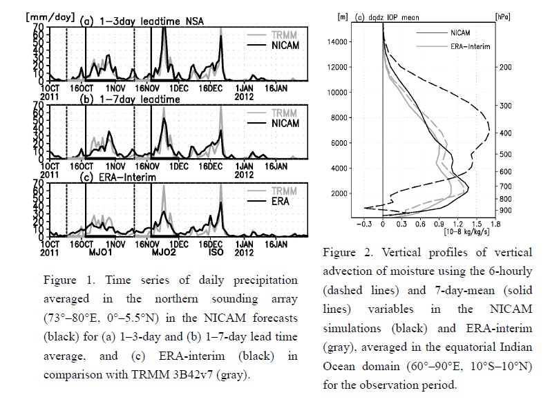
- The near real-time forecasts using Nonhydrostatic Icosahedral Atmospheric Model (NICAM) for the CINDY2011/DYNAMO were evaluated in comparison with observations. A week-long forecast was run each day with the finest mesh size of 14 km over the tropical Indian Ocean.
- The simulated precipitation time series fairly represented the sharp contrast associated with the MJO events (Fig. 1), although a 30% overprediction of precipitation was found on average. Frequencies of strong (>40 mm day-1) precipitation were overpredicted, while those of weak precipitation were underpredicted against satellite observations. Compared with the sounding observations, lower to middle tropospheric dry (∼1 g kg-1) and warm (∼1 K) biases were found.
- The moisture and energy budgets were investigated using the forecast data. The diagnosis using the 7-day-mean fields captured the observed features of the MJO events. Meanwhile, significant upward transport of moisture by the grid-resolved high-frequency variability was detected throughout the period (Fig. 2), which was markedly different from the diagnosis using ERA-interim (Fig. 2, gray lines). The high-frequency effects in NICAM partly accounted for the above mentioned performance and the moistening in the preconditioning period of the MJO.
Hoover et al. (2017)
Hoover, B. T., and R. H. Langland, 2017: Forecast and observation impact experiments in the Navy Global Environmental Model with assimilation of ECWMF analysis data in the global domain. J. Meteor. Soc. Japan, 95, 369-389.
https://doi.org/10.2151/jmsj.2017-023
Graphical Abstract
Highlights:
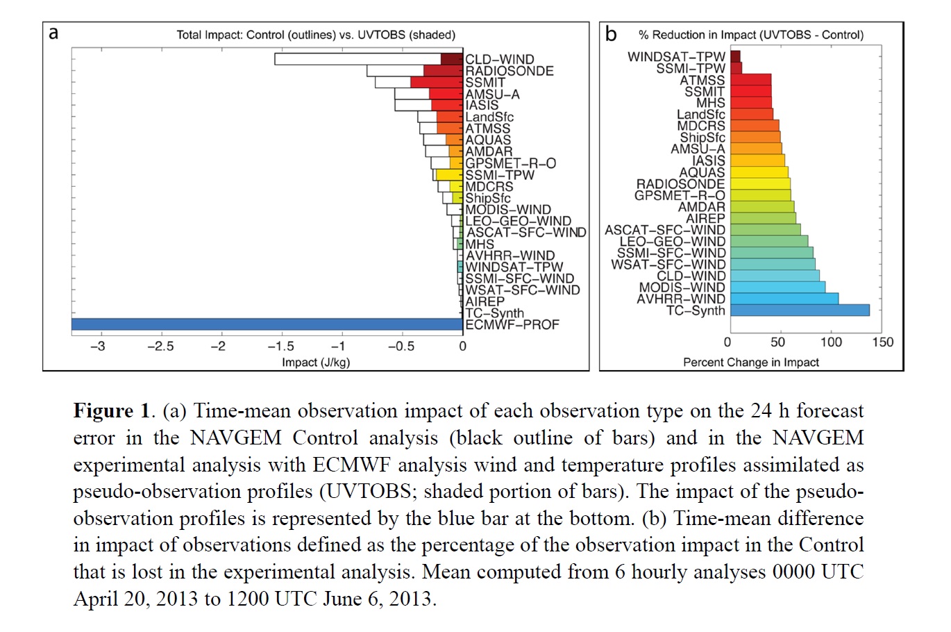
- The impact of assimilating profiles of analysis winds and temperatures computed globally from the European Centre for Medium Range Weather Forecasts (ECMWF) Integrated Forecast System (IFS) into the analysis of the Navy Global Environmental Model (NAVGEM) on the 24 h forecast error is investigated by computing the adjoint-derived observation impact on a 24 h forecast (moist energy) error norm both with and without assimilating the pseudo-observation profiles.
- The NAVGEM analysis draws closer to the ECMWF analysis, with cooling of analysis temperatures and lowering of analysis 500 hPa geopotential heights globally, with the largest changes to the analysis occurring in the southern high latitudes. These changes represent a bias reduction in the NAVGEM analysis that translates to significant forecast improvement.
- The time-mean adjoint-derived observation impact of each analysis type demonstrates that ECMWF pseudo-observation profiles contribute more to reducing the 24 h forecast error than any other observation type, and all other observation types express lower impact than they do in the Control (Fig. 1). The total observation impact across all observation types is lower in the experimental NAVGEM than in the Control, which is an indicator of an improved analysis-forecast system.
Putri et al. (2017)
Putri, N. S., T. Hayasaka, and K. D. Whitehall, 2017: The properties of mesoscale convective systems in Indonesia detected using the Grab ’Em Tag ’Em Graph ’Em (GTG) algorithm. J. Meteor. Soc. Japan, 95, 391-409.
https://doi.org/10.2151/jmsj.2017-026
Graphical Abstract
Highlights:
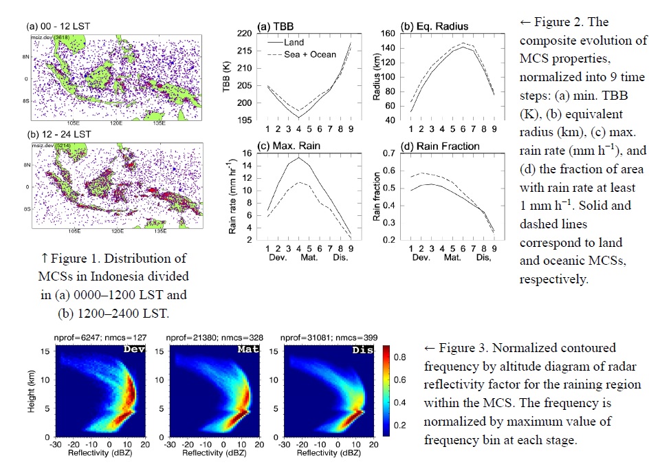
- The “Grab ’em Tag ’em Graph ’em” (GTG) tracking algorithm is applied to the hourly MTSAT-1R infrared data to study the properties of mesoscale convective systems (MCSs) over Indonesia region, including their distribution and how their properties change from developing (Dev), mature (Mat), t dissipating (Dis) stages. The CloudSat data products are also used to obtain an insight to the microphysica properties of the MCSs at these different stages.
- The distribution of MCSs over Indonesia has a seasonal variation and a distinct diurnal pattern: large formation of MCSs over land (resp. sea and ocean) during the day (resp. night) (Fig. 1). Compared to the oceanic (sea+ocean) MCS, the land MCS exhibits colder min. brightness temperature (TBB), smaller size, larger max. rain rate, and smaller rain fraction (Fig. 2). The differences of these two MCS types are particularly visible in the developing and mature stages.
- The MCSs have distinct cloud microphysics at different stages. At the developing stage, the raining region shows large occurrence of radar reflectivity ≥ 10 dBZ extending from 6 to 11 km, suggesting the presence of precipitating ice particles at these altitudes (Fig. 3). This mode becomes weaker in mature stage and the weakest in dissipating stage, indicating large hydrometeors no longer exist at the upper part of the raining region in dissipating stage. Within the MCS anvils, the dissipating stage shows a more uniform distribution of ice-particle effective radius compared to that shown by the developing and mature stages (figure not shown).
Kamae et al. (2017)
Kamae, Y., W. Mei, and S.-P. Xie, 2017: Climatological relationship between warm season atmospheric rivers and heavy rainfall over East Asia. J. Meteor. Soc. Japan, 95, 411-431.
https://doi.org/10.2151/jmsj.2017-027
Graphical Abstract
Highlights:
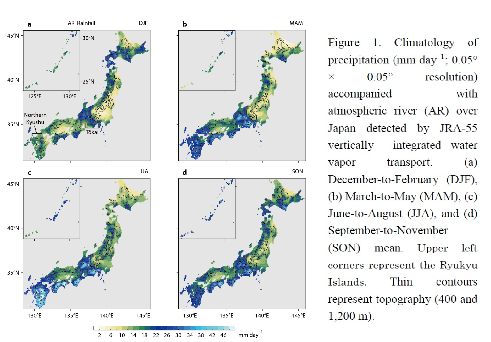
- This study evaluates contribution of atmospheric rivers (ARs) to the hydrological cycle over East Asia (Fig. 1) using high-resolution daily rainfall observations and vertically integrated water vapor transport in atmospheric reanalysis.
- ARs account for 14–44% of total rainfall and 20–90% of extreme heavy-rainfall events over East Asia during warm seasons despite their low occurrence.
- AR-related extreme rainfalls are especially dominant over western-to-southeastern slopes of terrains over the Korean Peninsula and Japan, owing to strong orographic effect and a stable direction of the low-level moisture flow.
- A strong relationship between warm-season AR heavy rainfall and preceding-winter El Niño is identified since the 1970s, suggesting a high seasonal predictability of AR-related natural disaster risk over Korea and Japan.
Kamae et al. (2017)
Terasaki, K., and T. Miyoshi, 2017: Assimilating AMSU-A radiances with the NICAM-LETKF. J. Meteor. Soc. Japan, 95, 433-446.
https://doi.org/10.2151/jmsj.2017-028
Graphical Abstract
Highlights:
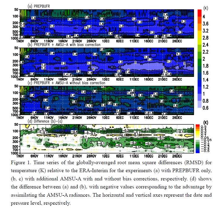
- This study developed an observation operator to assimilate the Advanced Microwave Sounding Unit-A (AMSU-A) brightness temperature observations with the Nonhydrostatic Icosahedral Atmospheric Model (NICAM)-based Local Ensemble Transform Kalman Filter (LETKF) using the radiative transfer model RTTOV (Radiative Transfer for the TOVS (TIROS Operational Vertical Sounder)) version 11.1.
- An adaptive bias correction method was applied for both airmass and scan biases, or the biases originating from the atmospheric state and scan position.
- Comparing the two experiments with and without the AMSU-A radiances, we find that the adaptive bias correction methods work appropriately, and that the analysis is significantly improved by assimilating the AMSU-A radiances (Fig. 1).
Notes and Correspondence
Sekiyama et al. (2017)
Sekiyama, T. T., M. Kajino, and M. Kunii, 2017: The impact of surface wind data assimilation on the predictability of near-surface plume advection in the case of the Fukushima nuclear accident. J. Meteor. Soc. Japan, 95, 447-454.
https://doi.org/10.2151/jmsj.2017-025
Graphical Abstract
Highlights:
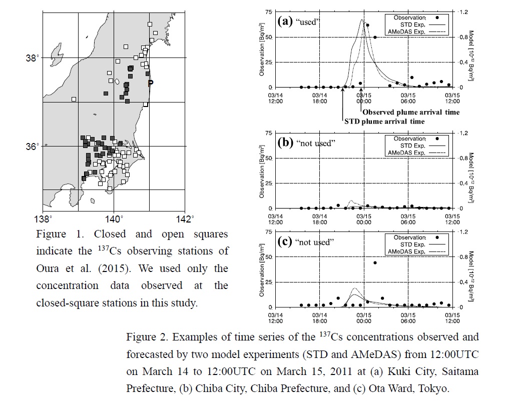
- We investigated the predictability of plume advection in the lower troposphere and the impact of AMeDAS surface wind data assimilation using the Japan Meteorological Agency non-hydrostatic weather prediction model and local ensemble transform Kalman filter (JMANHM-LETKF) data assimilation system with a 3-km horizontal resolution.
- The predicted radioactive cesium concentrations were examined for plume arrival times at 40 locations in the Tohoku and Kanto regions (Fig. 1) observed in March 2011.
- The mean error of the AMeDAS experiment (assimilating both the standard dataset and AMeDAS surface wind observations) was 72.8 minutes for plume arrival times, which was 9.2 minutes (11 %) better than that of the standard experiment (assimilating only the standard dataset) with a 13-hour lead-time on average.


