


JMSJ Highlights
Editor's Highlight : Shimada et al. (2024)
Shimada, U., M. Hayashi, and A. Mouche, 2024: A comparison between SAR wind speeds and western North Pacific tropical cyclone best track estimates.
J. Meteor. Soc. Japan
,
102
.
https://doi.org/10.2151/jmsj.2024-031
Early Online Release
Graphical Abstract
Editor in charge: Shoichi Shige
-
I highlight this paper that presents a comparison and evaluation of new SAR wind observations and conventional best track estimates for North Pacific typhoons (Editor in charge: Shoichi Shige).
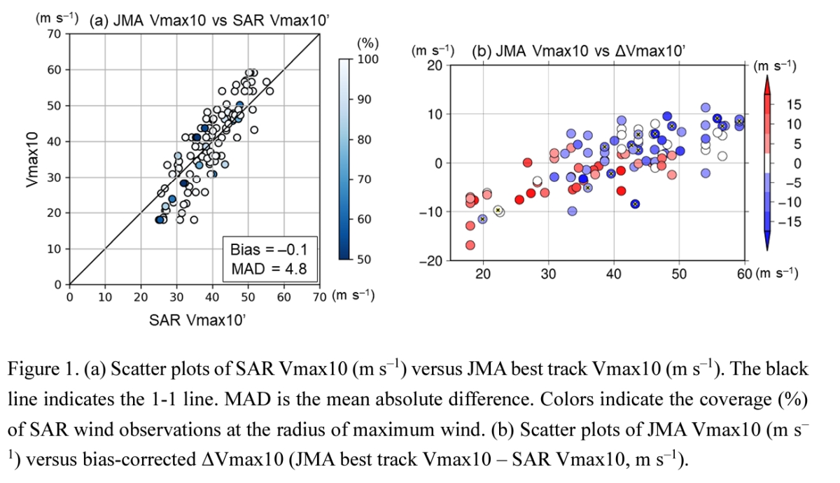
- The comparison between the SAR-derived 10-min maximum wind speed (Vmax10) and the JMA Vmax10 suggests that the actual Vmax10 of the TCs examined in this study increased earlier and started to decrease earlier than the JMA Vmax10.
- The JMA best track 30-kt wind radius is generally consistent with SAR wind speeds, whereas the JMA best track 50-kt wind radius is systematically underestimated relative to SAR wind speeds.
- Aside from the SAR wind limitations, possible reasons for the observed discrepancies between SAR wind observations and best track estimates include biases in the Dvorak analysis and conventional surface wind products.
Abstract
Spaceborne synthetic aperture radar (SAR) for measuring high winds is expected to reduce uncertainties in tropical cyclone (TC) intensity and structure estimation, yet the consistency of SAR observed winds equivalent to a 1-min sustained wind speed with the conventionally estimated 10-min maximum wind speed (Vmax10) remains to be assessed. This study compares SAR wind observations with western North Pacific best track estimates from the Japan Meteorological Agency (JMA) and the Joint Typhoon Warning Center (JTWC). Because SAR wind observations have a bias dependent on SAR incidence angle, a first order corrective term is proposed and used to correct SAR-derived maximum wind (SAR Vmax) tentatively. After this correction, conversion of SAR Vmax into SAR Vmax10 with Dvorak conversion tables revealed a mean difference between SAR Vmax10 and JMA Vmax10 (ΔVmax10) of –0.1 m s–1 and a mean absolute difference of 4.8 m s–1. ΔVmax10 is found to be correlated with current intensities and with subsequent intensity changes from the SAR observation time. Also, comparison of the JMA best track 50-kt wind radius (R50) with SAR wind speeds suggests that R50 is systematically underestimated. Aside from the SAR wind limitations, possible reasons for the observed discrepancies between SAR wind observations and best track estimates include biases in the Dvorak analysis and conventional surface wind products. Further accumulation of SAR wind observations with appropriate bias correction in the future is expected to contribute to a comprehensive evaluation and improvement of conventional Vmax estimation methods, which could also be useful to verify TC intensity forecasts.