Graphical Abstract
JMSJ, 2022, Vol. 100, No. 1 (February)
Article
Steppler et al. (2022)
Steppeler, J., J. Li, F. Fang, and J. Zhu, 2022: The o2o3 Local Galerkin method using a differentiable flux representation. J. Meteor. Soc. Japan, 100, 9-27.
https://doi.org/10.2151/jmsj.2021-077
Graphical Abstract
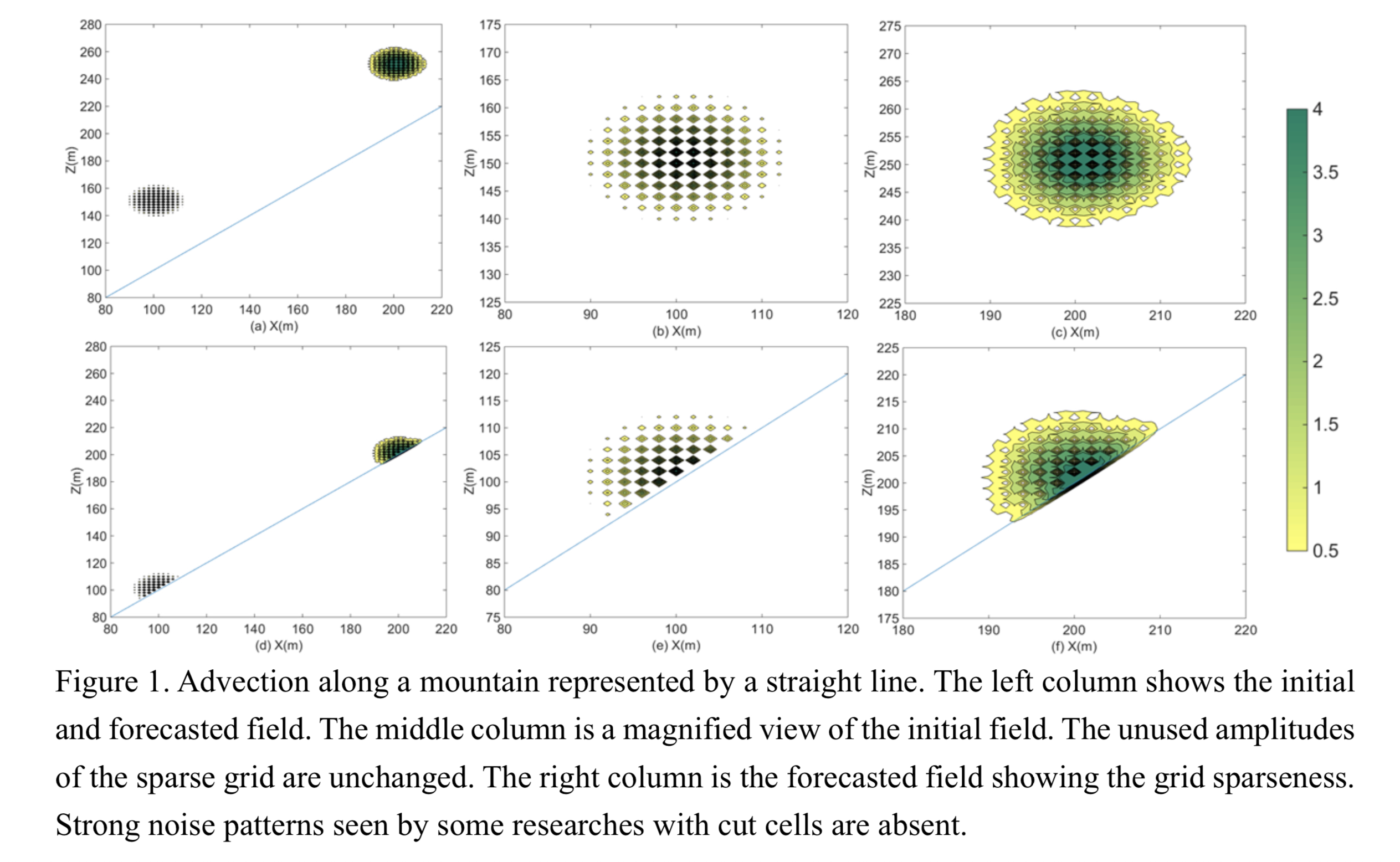
Plain Language Summary: Local Galerkin methods, in particular the spectral elements (SE) solve the difficulty in classic Galekin methods for applying to multiprocessor system and have been found to be scalable up to millions of processors. The present study investigates improvements of SE under the name o2o3 which substitutes the irregular Gauss-Lobatto grid in SE by a regular collocation grid to compute Galerkin integrals with the potential to improve the computational efficiency and simplify the physical parameterization.
Highlights:
- The accuracy of o2o3 is comparable to that of third-order SE (SE3) as a result of the constructed superconvergence.
- Compared with SE3, o2o3 utilizes a regular grid enabling to use a larger time step with the potential to generate sparse grids and improve the computational efficiency even when parameterizing physical processes.
- o2o3 is suitable to formulate lower boundary conditions for irregular surfaces, thus allowing to formulate the high-order cut-cell approximation.
Article
Shibata and Naoe (2022)
Shibata, K. and H. Naoe, 2021: Decadal amplitude modulations of the stratospheric quasi-biennial oscillation. J. Meteor. Soc. Japan, 100, 29-44.
https://doi.org/10.2151/jmsj.2022-001
Graphical Abstract
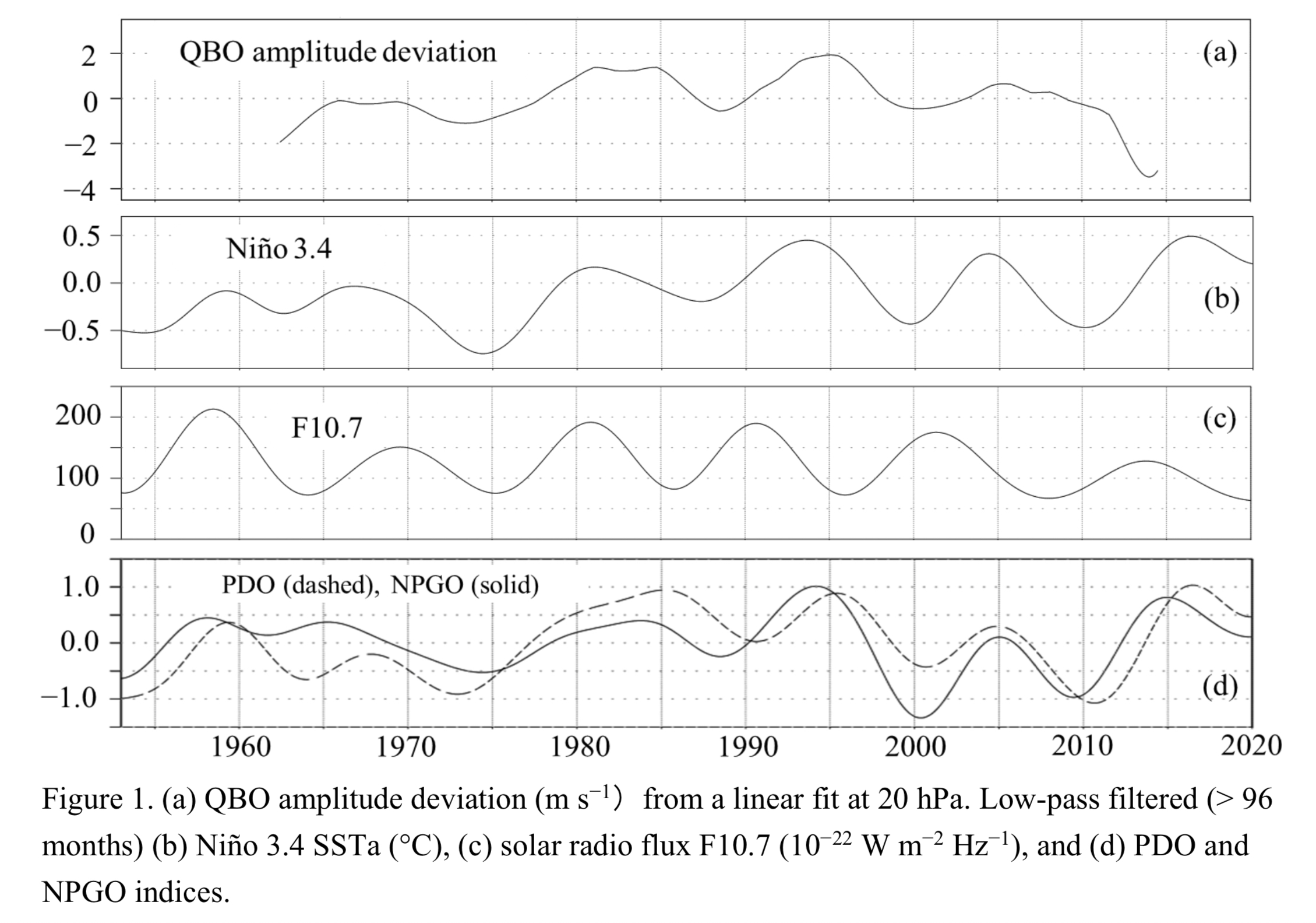
Plain Language Summary: Analyses of Singapore radiosonde and reanalysis data from 1950s show that the quasi-biennial oscillation (QBO) in the equatorial stratosphere is decadally modulated in the amplitude as well as in the period. These two decadal variations are positively correlated with each other after 1980s, while they show approximately negative correlation before 1980s. The decadal amplitude variations of the QBO are not correlated with the solar cycle, but closely and positively correlated with the decadal components of Niño 3.4 sea surface temperature anomalies (SSTa), Pacific decadal oscillation (PDO) index, and North Pacific gyre oscillation (NPGO) index, suggesting that the tropical SSTa in the central Pacific substantially influences the QBO in the decadal time-scales.
Highlights:
- In the time series of the QBO amplitude from 1950s to 2014, there are four maxima (QBOmax) around 1967, 1983, 1995, and 2005, and three minima (QBOmin) around 1973, 1988, and 2000.
- Composite analyses of QBOmax and QBOmin based on these extrema reveal that the decadal amplitude variations have maximum amplitude of about 3 m s−1 at 20 hPa in the vertical.
- In the horizontal structure there appear off-equator extrema of about 3.5 m s−1 around 5ºN at 20 hPa, while at 50 hPa extrema of about 1.8 m s−1 are situated around 5ºS.
Article: Special Edition on Global Precipitation Measurement (GPM): 5th Anniversary
Nakai et al. (2022)
Nakai, S., K. Yamashita, H. Motoyoshi, T. Kumakura, S. Murakami, and T. Katsushima, 2021: Relationships between radar reflectivity factor and liquid-equivalent snowfall rate derived by direct comparison of X-band radar and disdrometer observations in Niigata Prefecture, Japan. J. Meteor. Soc. Japan, 100, 45-56.
Special Edition on Global Precipitation Measurement (GPM): 5th Anniversary,
https://doi.org/10.2151/jmsj.2022-002
Graphical Abstract
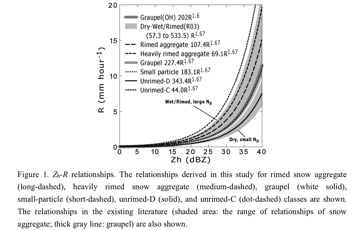
Plain Language Summary: The relationships between the radar reflectivity factor for horizontal polarization (Zh) at X-band and liquid-equivalent snowfall rate (R), of the form Zh = B R1.67, are presented for six hydrometeor classes of solid precipitation. Snow aggregates demonstrated a stronger or weaker backscattering than graupel of the same R depending on the riming degree and types of constituent ice crystals in the X-band.
Highlights:
- The average B value for the “heavily rimed snow aggregate” was smaller than that for the “rimed snow aggregate”.
- The largest B value was derived for a case of aggregates of unrimed dendritic particle (unrimed-D class). The case involving the aggregates of unrimed low-temperature-type crystals (unrimed-C class) showed the smallest B value.
- For graupel cases, the average B value was roughly twice that of the rimed and heavily rimed snow aggregate classes and much smaller than that of the unrimed-D class.
Article
Chang et al. (2022)
Chang, Y., Q. Ma, L. Guo, J. Duan, J. Li, X. Zhang, X. Guo, X. Lou, and B. Chen, 2022: Characteristics of raindrop size distributions during Meiyu season in Mount Lushan, eastern China. J. Meteor. Soc. Japan, 100, 57-76.
https://doi.org/10.2151/jmsj.2022-003
Graphical Abstract
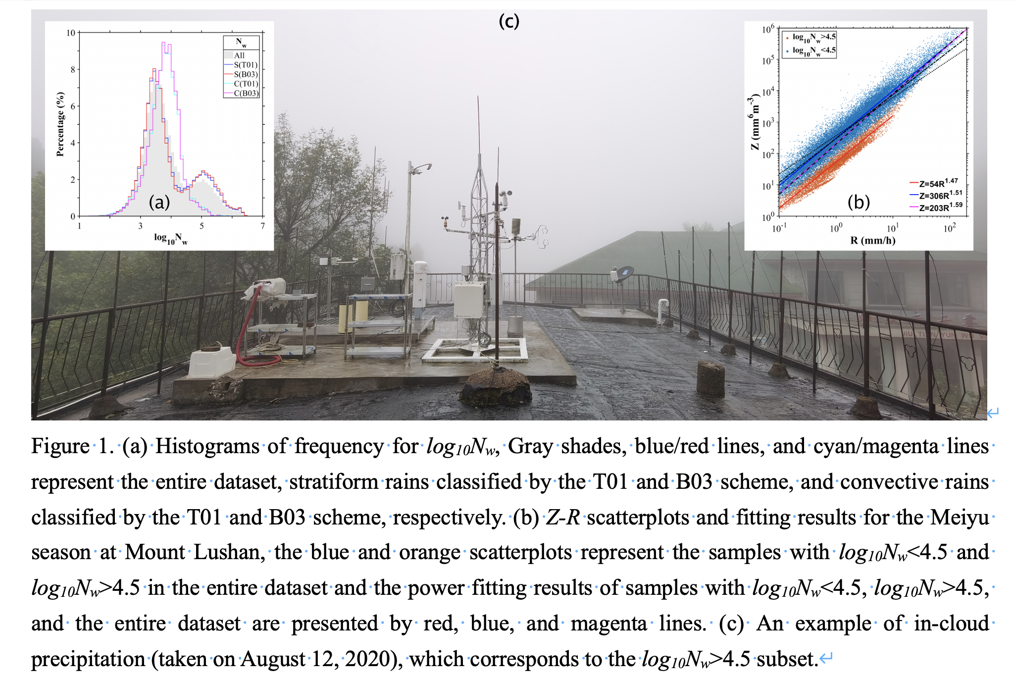
Plain Language Summary: Using long-term laser disdrometer data, we investigated the raindrop size distribution (RSD) characteristics of Meiyu precipitation in Mount Lushan, eastern China. Statistical properties for RSD parameters in mountainous site of different rain rates and rain types are presented. Parameterization schemes for RSD description and precipitation estimation for Meiyu precipitation are derived. The results show that the mountainous topography plays an important role in reshaping the characteristics of RSD and the physical processes of precipitation.
Highlights:
- Long-term laser disdrometer observed RSD data are used to investigate Meiyu precipitation in a mountainous site.
- The relations between gamma distribution parameters (μ-Λ), and for quantitative precipitation estimation (Z-R) are derived.
- A specific RSD subset with high Nw (log10Nw>4.5) is assessed, which is caused by mountainous topography induced continuous in-cloud precipitation.
- The mountainous topography plays an important role in reshaping the characteristics of RSD and the physical processes of precipitation.
Article: Special Edition on Global Precipitation Measurement (GPM): 5th Anniversary
Nur'utami and Hayasaka (2022)
Nur'utami M. N. and T. Hayasaka, 2022: Interannual variability of the Indonesian rainfall and air–sea interaction over the Indo–Pacific associated with Interdecadal Pacific Oscillation phases in the dry season. J. Meteor. Soc. Japan, 100, 77-97.
https://doi.org/10.2151/jmsj.2022-004
Graphical Abstract
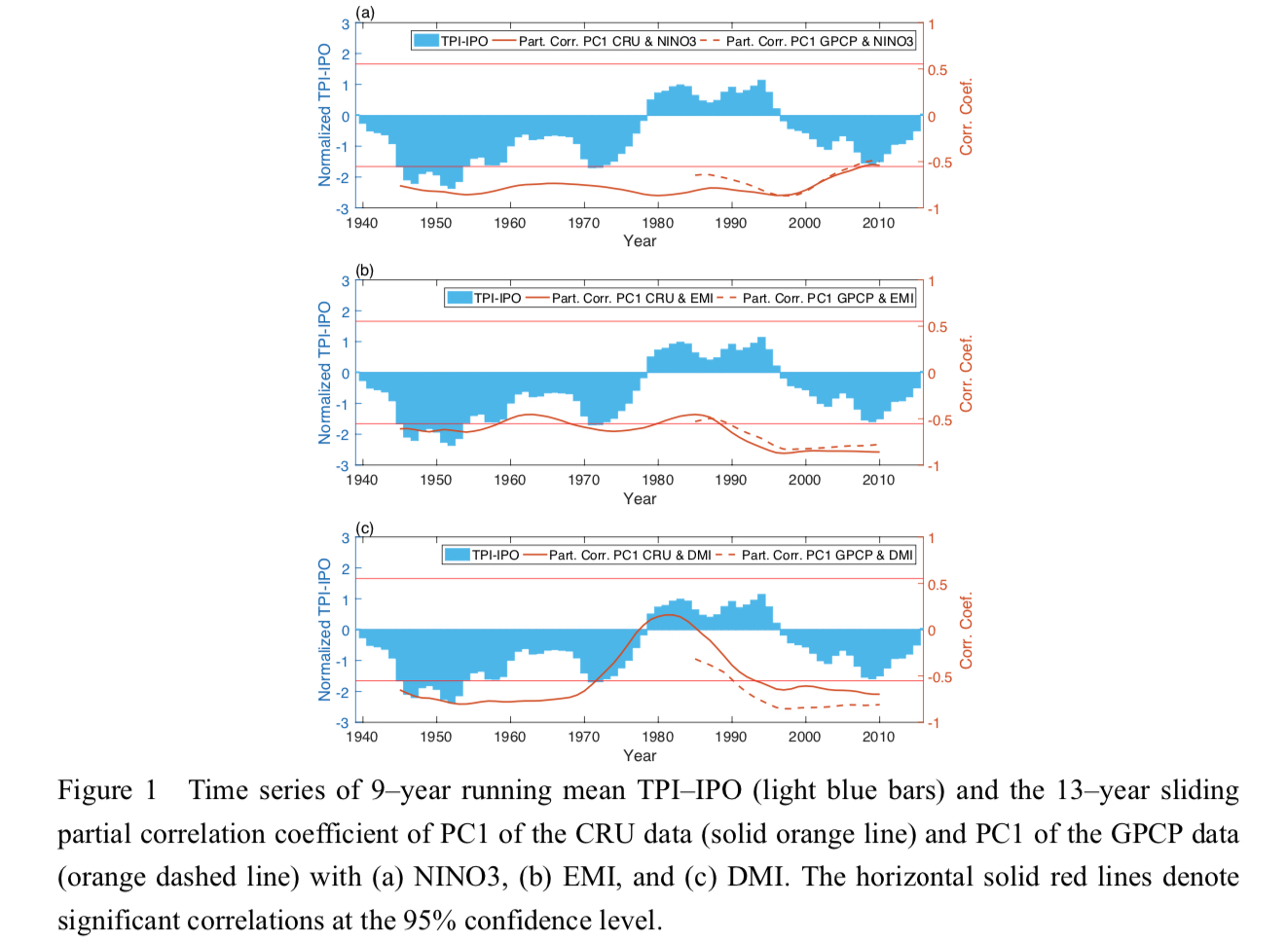
Plain Language Summary: The Indo-Pacific climate modes have important impacts on Indonesian climate. While the influences of the canonical El Niño–Southern Oscillation (ENSO), ENSO Modoki, and Indian Ocean Dipole (IOD) on Indonesian rainfall are statistically significant, their modulation due to the Interdecadal Pacific Oscillation (IPO) has not been understood. It is found that IOD influences are enhanced during the negative phase of IPO. On the other hand, we found no evidence that the IPO modulates the Indonesian rainfall responses to canonical ENSO and ENSO Modoki.
Highlights:
- Canonical ENSO, ENSO Modoki, and IOD have interesting spatially different impacts on Indonesian rainfall variability.
- The response of Indonesian rainfall to ENSO Modoki is more significant than that for canonical ENSO in recent years.
- The modulation of IOD influences due to IPO is proposed; that is, the impact of IOD is weak during the positive IPO and strong during the negative IPO.
Article
Yulihastin et al. (2022)
Yulihastin, E., T. W. Hadi, M. R. Abdillah, I. R. Fauziah, and N. S. Ningsih, 2022: Propagation of convective systems associated with early morning precipitation and different northerly background winds over western Java. J. Meteor. Soc. Japan, 100, 99-113.
Special Edition on Years of the Maritime Continent (YMC),
https://doi.org/10.2151/jmsj.2022-005
Graphical Abstract
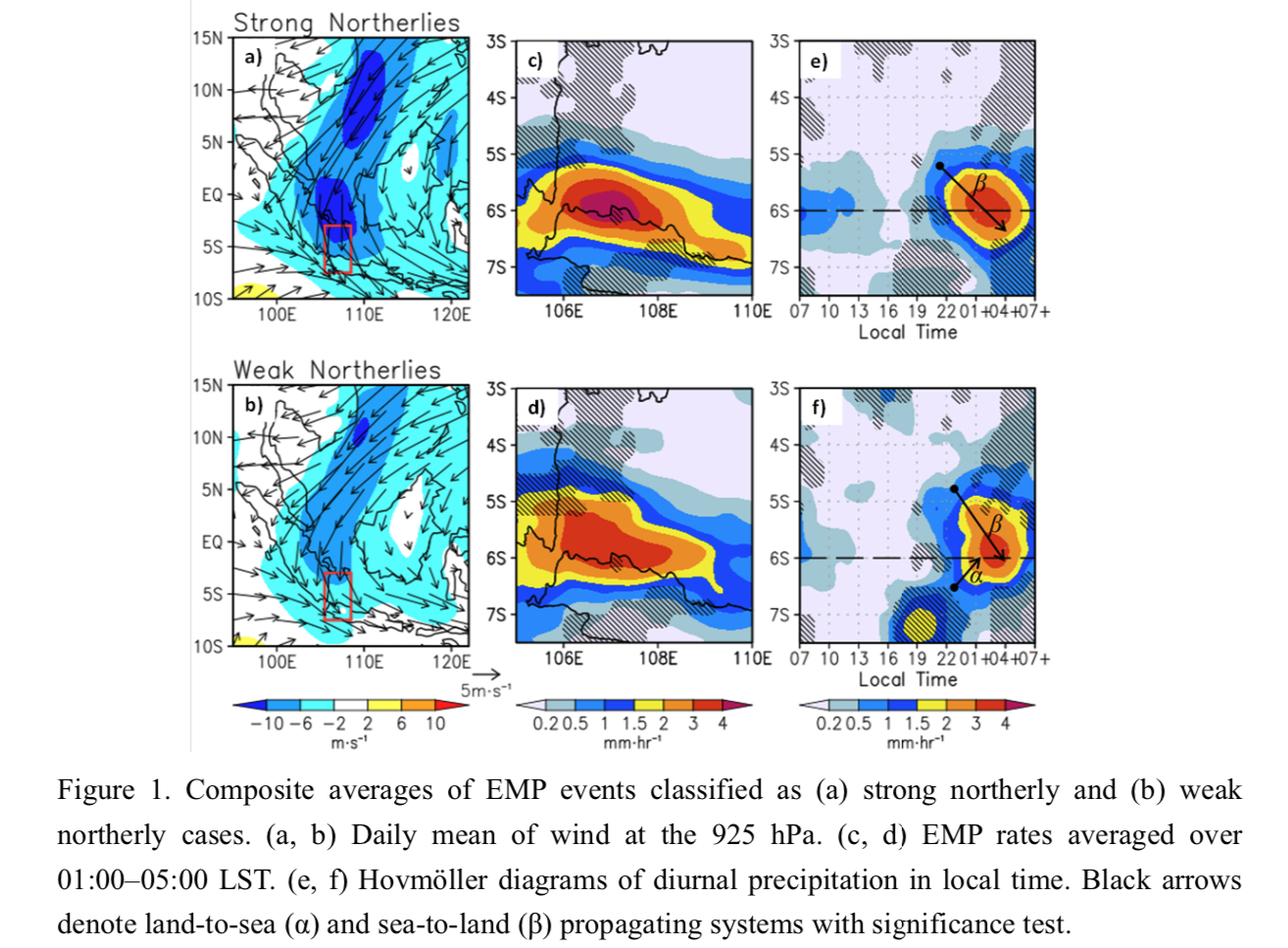
Plain Language Summary: The early morning precipitation (EMP) events over the northern coast of western Java are characterized by propagating convective systems. We found that these propagating precipitation systems are modulated background wind conditions. The EMP is mainly induced by a precipitation system that propagates from sea to land in cases of both strong northerly (SN) and weak northerly (WN) wind background. In case of WN, the propagating systems moving from inland to the sea also play a role on the EMP. We suggest that the propagations are sustained by cold pool and background wind interactions.
Highlights:
- Cold pool propagation and its advection by the prevailing winds is responsible for the propagating convection, which explains its dependence on the strength of background wind.
Article
Takemura and Mukougawa (2022)
Takemura, K. and H. Mukougawa, 2022: A new perspective of Pacific–Japan pattern: Estimated percentage of the cases triggered by Rossby wave breaking. J. Meteor. Soc. Japan, 100, 115-139.
https://doi.org/10.2151/jmsj.2022-006
Graphical Abstract
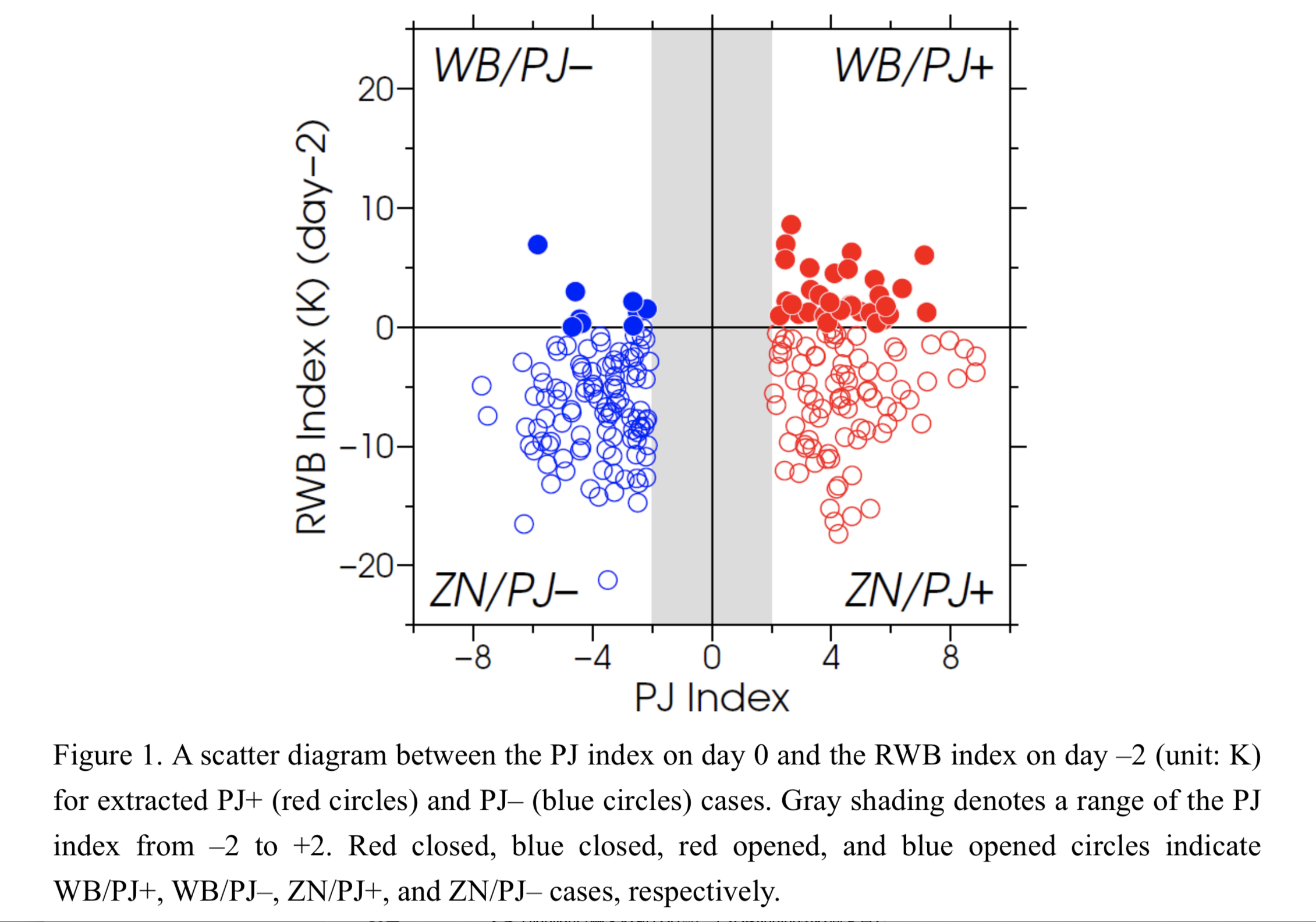
Plain Language Summary: This study quantitatively examined a relative importance of Rossby wave breaking (RWB) east of Japan to a formation of the Pacific–Japan (PJ) pattern compared with that of tropical atmospheric and oceanographic conditions. Cases of the positive/negative PJ patterns are firstly classified into those with and without the RWB occurrence, which are referred to as WB/PJ+/– and ZN/PJ+/–, respectively. The main findings obtained in this study are summarized as follows.
Highlights:
- Cases of the positive PJ pattern triggered by the RWB account for approximately 20% of the whole cases of the positive PJ pattern.
- Composite of the positive PJ pattern with the presence of RWB shows that the RWB promotes the formation of the PJ pattern through the equatorward intrusion of high PV air.
- The formation of the PJ pattern with the absence of RWB are closely associated with tropical sea surface temperature anomalies and phase of the boreal summer intra-seasonal oscillation, illuminating “pure” tropical impacts on the formation of the PJ pattern.
Article
Tochimoto et al. (2022)
Tochimoto, E., S. Yokota, H. Niino, and W. Yanase, 2022: Ensemble experiments for a maritime meso-β-scale vortex that spawned tornado-like vortices causing shipwrecks. J. Meteor. Soc. Japan, 100, 141-165.
https://doi.org/10.2151/jmsj.2022-007
Graphical Abstract
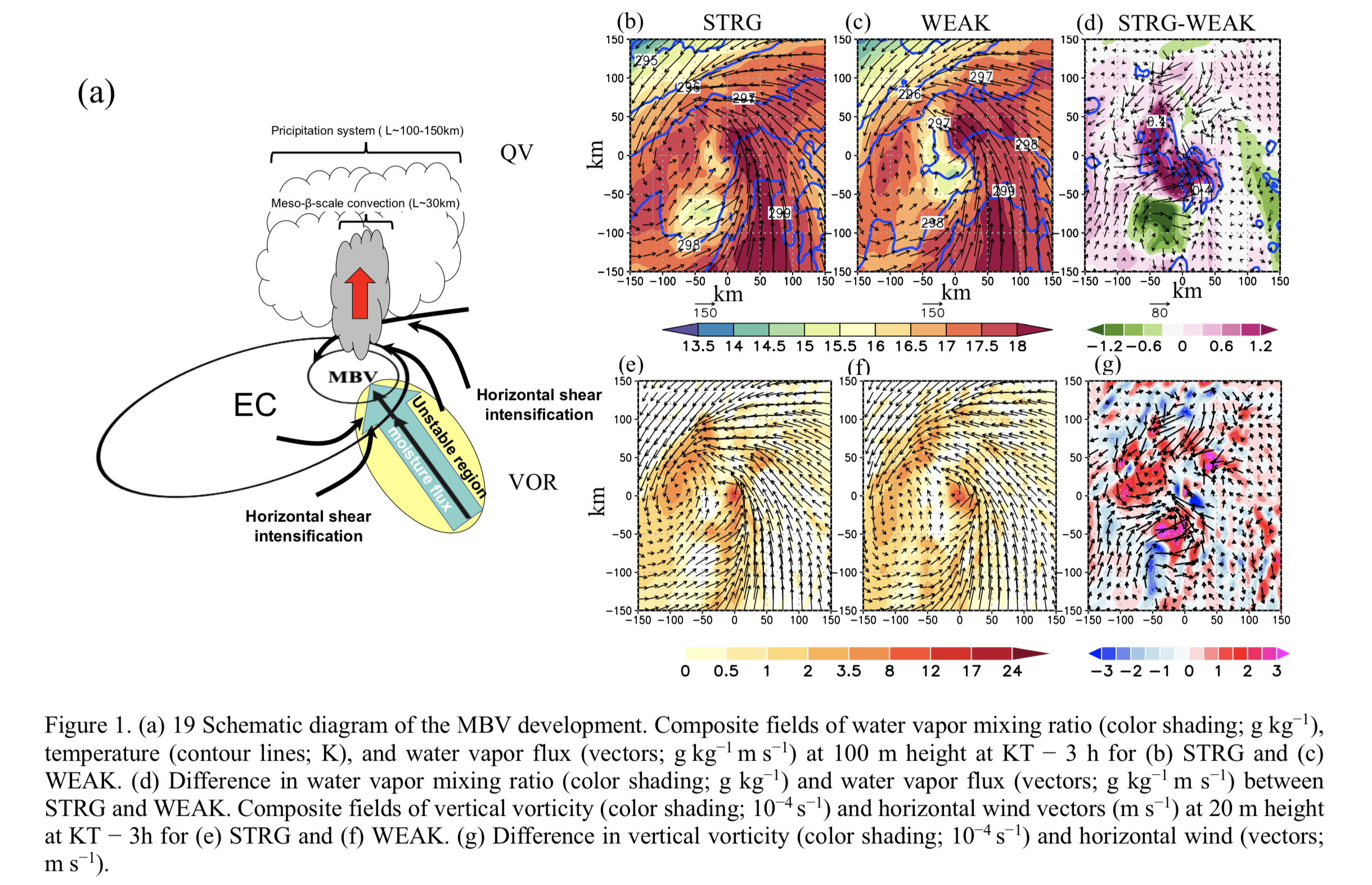
Plain Language Summary: A meso-β-scale vortex (MBV) that caused 5 shipwrecks as a result of sudden gusty winds in the southwestern part of the Sea of Japan on 1 September 2015. This study with ensemble forecasts with 101 members, including one ensemble mean, revealed that the near-surface cyclonic horizontal shear to the northeast and the south of the MBV was crucial for the development of the MBV. In addition, larger low-level water vapor and its horizontal flux result in stronger convection around the MBV.
Highlights:
- A composite analysis and an ensemble-based sensitivity analysis were conducted to understand the atmospheric conditions favorable for the development of a meso-β-scale vortex (MBV).
- The near-surface cyclonic horizontal shear to the northeast and the south of the MBV was crucial for the development of the MBV.
- In addition, larger low-level water vapor and its horizontal flux contribute to greater convective available potential energy to the southeast of the MBV, which results in stronger convection around the MBV.
Article
Liu et al. (2022)
Liu, Y. L., C.-Y. Tam, and A. Y. M. Au-Yeung, 2022: Sensitivity of western north Pacific summertime tropical synoptic-scale disturbances to extratropical forcing – A regional climate model study. J. Meteor. Soc. Japan, 100, 167-180.
https://doi.org/10.2151/jmsj.2022-008
Graphical Abstract
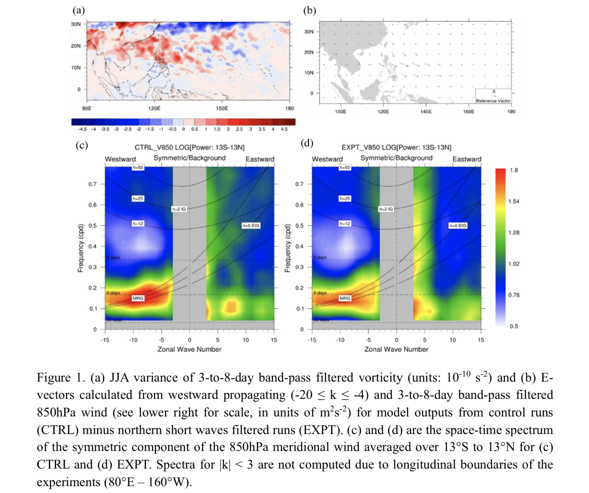
Plain Language Summary: This study investigates the contribution of extratropical forcing in triggering summertime tropical synoptic-scale disturbances (TSDs) and their later development over the western north Pacific region. When short wave signals from the extratropical region are filtered out, TSD activity, as well as the related rainfall, are both suppressed. Mixed Rossby gravity waves in the equatorial western Pacific area are also weakened due to less wave activity propagated from the north. Further inspection reveals that both the strength as well as coherency of the eddies, over different parts of the TSD wavetrain, can be affected by extratropical forcing in relation to the upper- level westerly pattern.
Highlights:
- The contribution of the extratropical forcing in the amplitude and characteristics of tropical synoptical-scale disturbances (TSDs) over the western north Pacific is analysed.
- When short waves from the extratropical region are filtered, TSD activity and its related rainfall are suppressed.
- Mixed Rossby gravity waves over the equatorial western Pacific region are also weakened without extratropical forcing.
- Extratropical forcing can influence TSD through the intrusion of wave activity and modulation of background circulation.
Article: Special Edition on Typhoons in 2018–2019
Miyamoto et al. (2022)
Miyamoto, Y., H. Fudeyasu, and A. Wada, 2022: Intensity and structural changes of numerically simulated Typhoon Faxai (1915) before landfall. J. Meteor. Soc. Japan, 100, 181-196.
Special Edition on Typhoons in 2018–2019,
https://doi.org/10.2151/jmsj.2022-009
Graphical Abstract
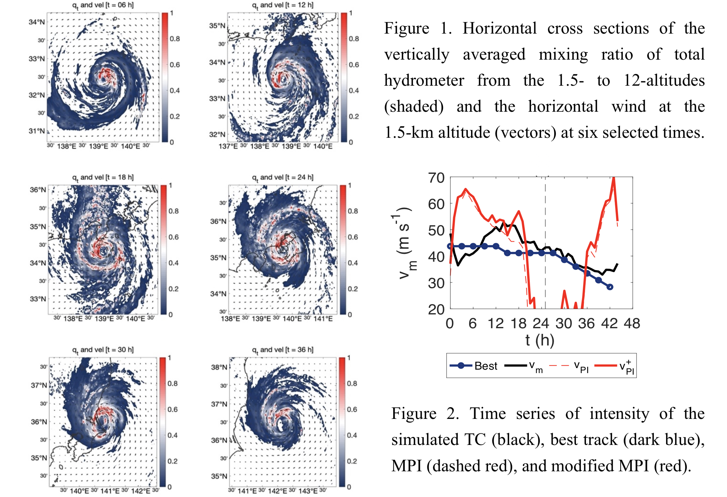
Plain Language Summary: A numerical simulation for Typhoon Faxai (1915), which made landfall with the central pressure of 960 hPa in the Kanto region of Japan was conducted. The simulation successfully simulated the realistic track and intensity of Faxai for 48 h around landfall. The simulated intensity was strong until the time of landfall. The structure, identified as having an axisymmetric flow field and eyewall, was similar to that of a well-developed tropical cyclone (TC) in the tropics. Around the TC center, the surface latent heat flux was large while the vertical wind shear was relatively weak at midlatitudes. The simulated and best track TC intensities exceeded the maximum potential intensity (MPI) for approximately 12 h before landfall. It is implied that the structure of TC is similar to that of a developed TC in the tropics. The present analyses suggest that the strong intensity of Faxai results from favorable environmental conditions and vortex structure.
Highlights:
- A numerical simulation indicates that the strong intensity of Typhoon Faxai (1915) resulted from favorable environmental conditions and vortex structure.
- The surface latent heat flux is large and vertical wind shear was weak until the landfall.
- The intensity exceeded the maximum potential intensity before the landfall.
Article: Special Edition on Global Precipitation Measurement (GPM): 5th Anniversary
Goto and Uchida (2022)
Goto, D., and J. Uchida, 2022: Uncertainty in aerosol rainout processes through the case of the radioactive materials emitted by the Fukushima Dai-ichi Nuclear Power Plant in March 2011. J. Meteor. Soc. Japan, 100, 197-217.
https://doi.org/10.2151/jmsj.2022-010
Graphical Abstract
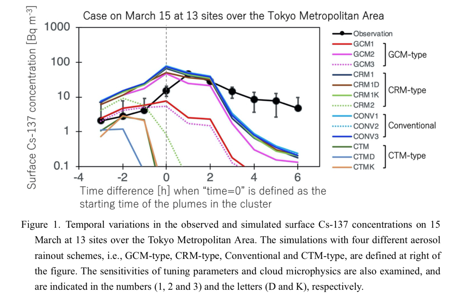
Plain Language Summary: An intercomparison study of four aerosol wet deposition schemes on the model was performed to simulate particulate Cs-137 in the emission scenario of the March 2011 accident at the Fukushima Dai-ichi Nuclear Power Plant. Additional tests were also conducted on the sensitivity of aerosol tuning parameters and the impact of aerosol-cloud interactions. It is found that a proper set of rainout parameterizations and tunings are as important as the accurate meteorological fields, i.e., wind and water vapor, in determining the reproducibility of Cs-137 aerosol simulations.
Highlights:
- When the tuning parameters are properly set, all the schemes except CTM-type, are capable of closely resembling the observation.
- The shortcomings of CTM-type may be rooted in the model tendency (of NICAM), which has unusually high cloud water-to-precipitation conversion rate.
- The sensitivity of cloud microphysics on the simulated Cs-137 concentration is smaller than that of the wet deposition schemes
Article
Kudo (2022)
Kudo, A., 2022: Statistical post-processing for gridded temperature prediction using encoder‒decoder-based deep convolutional neural networks. J. Meteor. Soc. Japan, 100, 219-232.
https://doi.org/10.2151/jmsj.2022-011
Graphical Abstract
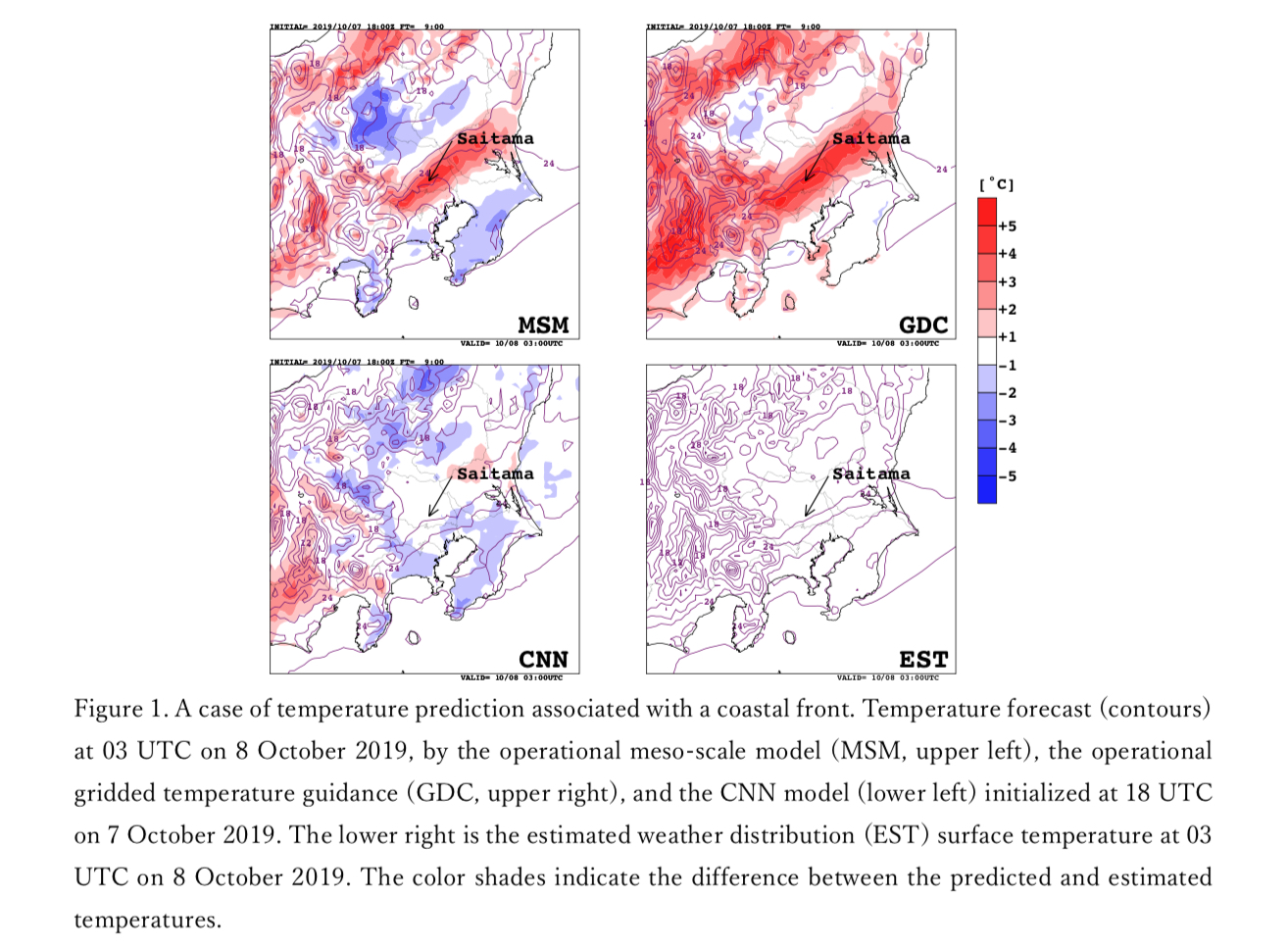
Plain Language Summary: In this study, an encoder‒decoder-based convolutional neural network (CNN) has been proposed to predict gridded temperatures at the surface around the Kanto region in Japan. Verification results showed that the proposed model greatly improves the Japan Meteorological Agency's (JMA's) operational gridded temperature guidance and can correct NWP model biases, such as a positional error of coastal fronts (Fig. 1) and extreme temperatures.
Highlights:
- Seven-layer deep CNN model, which inputs seven MSM output variables, was used to predict 2- dimensional temperature field around the Kanto region.
- Verificationresultsusinganindependentdatasetfromtrainingandvalidationdatasetsshowedthatthe proposed CNN model greatly improved the JMA's operational gridded temperature guidance.
- The CNN model can predict temperatures associated with radiative cooling, coastal fronts, and heatwaves, which have been difficult to correct using the operational temperature guidance.
Article
Huang and Raghunathan (2022)
Huang, H.-P., and G. N. Raghunathan, 2022: Predictability associated with high-latitude retrograde waves in the 1979-80 winter season. J. Meteor. Soc. Japan, 100, 233-243.
https://doi.org/10.2151/jmsj.2022-012
Graphical Abstract
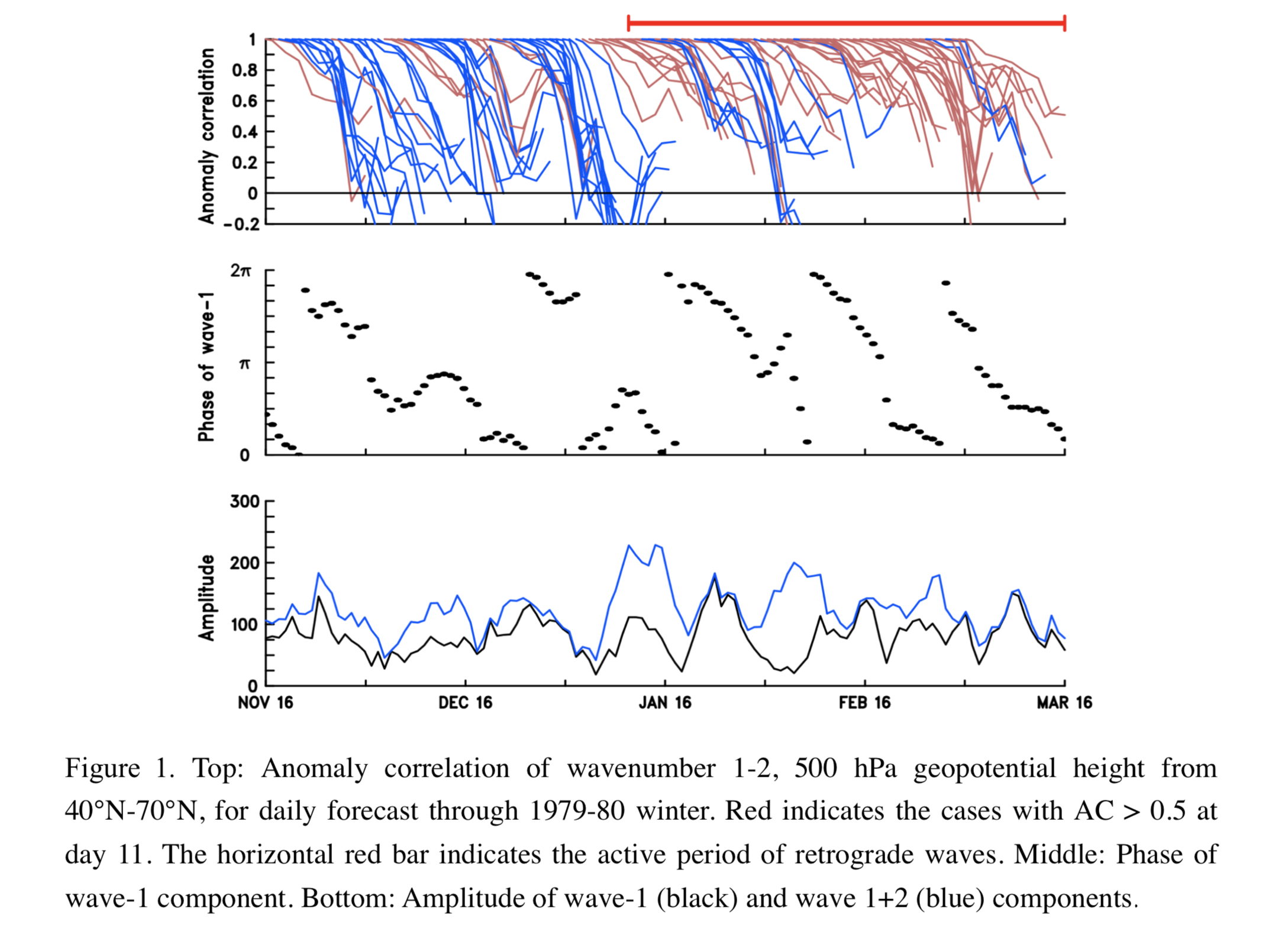
Plain Language Summary: The presence of coherent retrograde waves is found to influence extended-range weather forecast in the higher latitudes of the Northern Hemisphere. In the 1979-80 winter season, ensemble reforecasts made within the active period of retrograde waves exhibit an elevated level of anomaly correlation of 500 hPa geopotential height in week-2. The enhanced predictability is particularly significant for the long-wave components.
Highlights:
- The analysis is based on daily ensemble reforecast data, with the anomaly correlation computed for the full 500 hPa geopotential height field and its long-wave and short-wave components.
- Active and inactive periods of retrograde waves are identified based on the coherence of phase propagation of the wavenumber-1 component.
- The methodology used for the analysis of one winter season can be adopted for a multi-year analysis in future work.
Article
Nakanishi et al. (2022)
Nakanishi, M., H. Niino, and T. Anzai, 2022: Stability functions in the stable surface layer derived from the Mellor–Yamada–Nakanishi–Niino (MYNN) scheme. J. Meteor. Soc. Japan, 100, 245-256.
https://doi.org/10.2151/jmsj.2022-013
Graphical Abstract
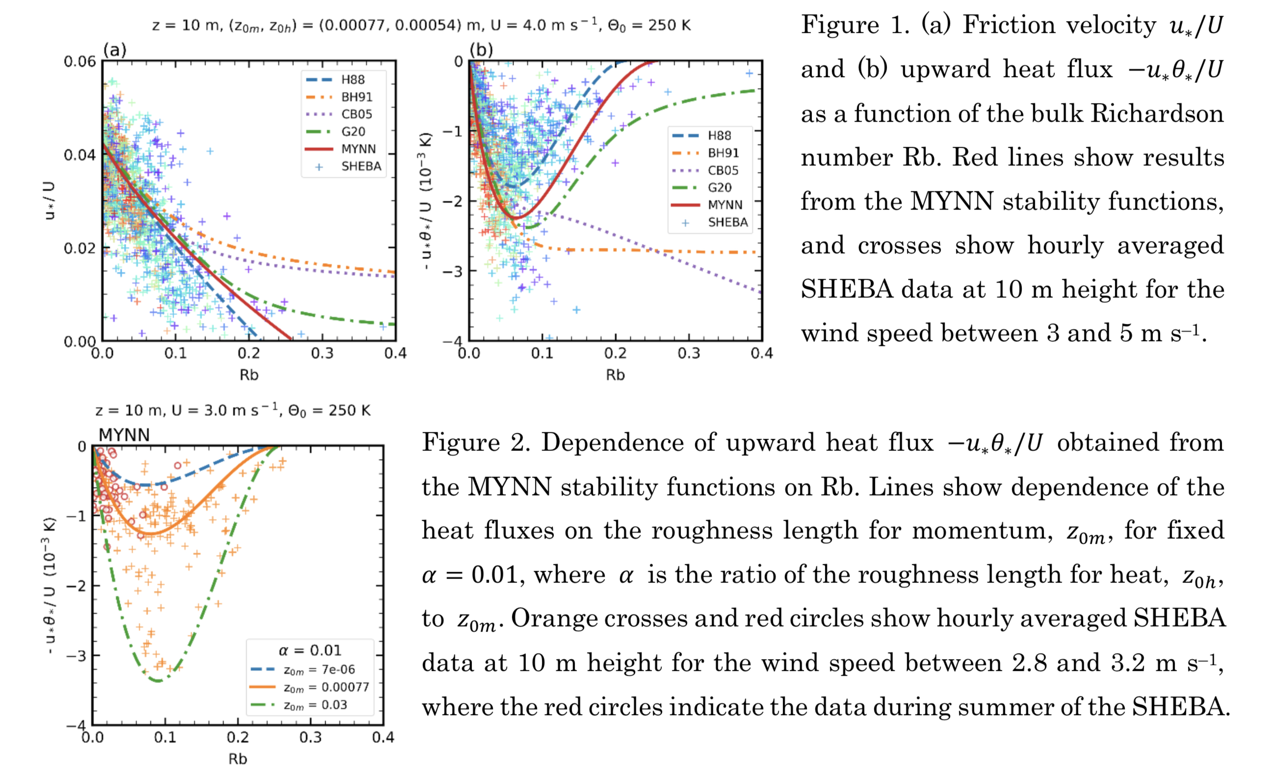
Plain Language Summary: Stability functions based on Monin–Obukhov similarity theory for momentum and heat in the stable surface layer are derived from the Mellor–Yamada–Nakanishi– Niino (MYNN) scheme. The resulting “MYNN” stability functions can be approximated by linear functional forms. Momentum and heat fluxes obtained from the MYNN stability functions are compared with those from previously proposed stability functions and observational data of the Surface Heat Budget of the Arctic Ocean experiment (SHEBA).
Highlights:
- Momentum and heat fluxes obtained from the MYNN stability functions show good agreement with hourly averaged SHEBA data at 10 m height.
- The MYNN stability functions suggest that significant variations of the fluxes observed for a period of winter when the ice was covered with dry snow may have been caused by those of the surface roughness around the observational site.
- The MYNN stability functions predict that the bulk and flux Richardson numbers approach critical values of 0.26 and 0.21, respectively, in the limit of 𝑧/𝐿 → ∞, where 𝐿 is the Obukhov length.
- These critical values result from Kolmogorov hypothesis applied to the turbulent dissipation in the MYNN scheme and are considered to correspond to a transition from Kolmogorov to non- Kolmogorov turbulence.
Article
Takahashi et al. (2022)
Takahashi, C., Y. Imada, and M. Watanabe, 2022: Influence of the Madden-Julian Oscillation on wintertime extreme snowfall and precipitation in Japan. J. Meteor. Soc. Japan, 100, 257-283.
https://doi.org/10.2151/jmsj.2022-014
Graphical Abstract
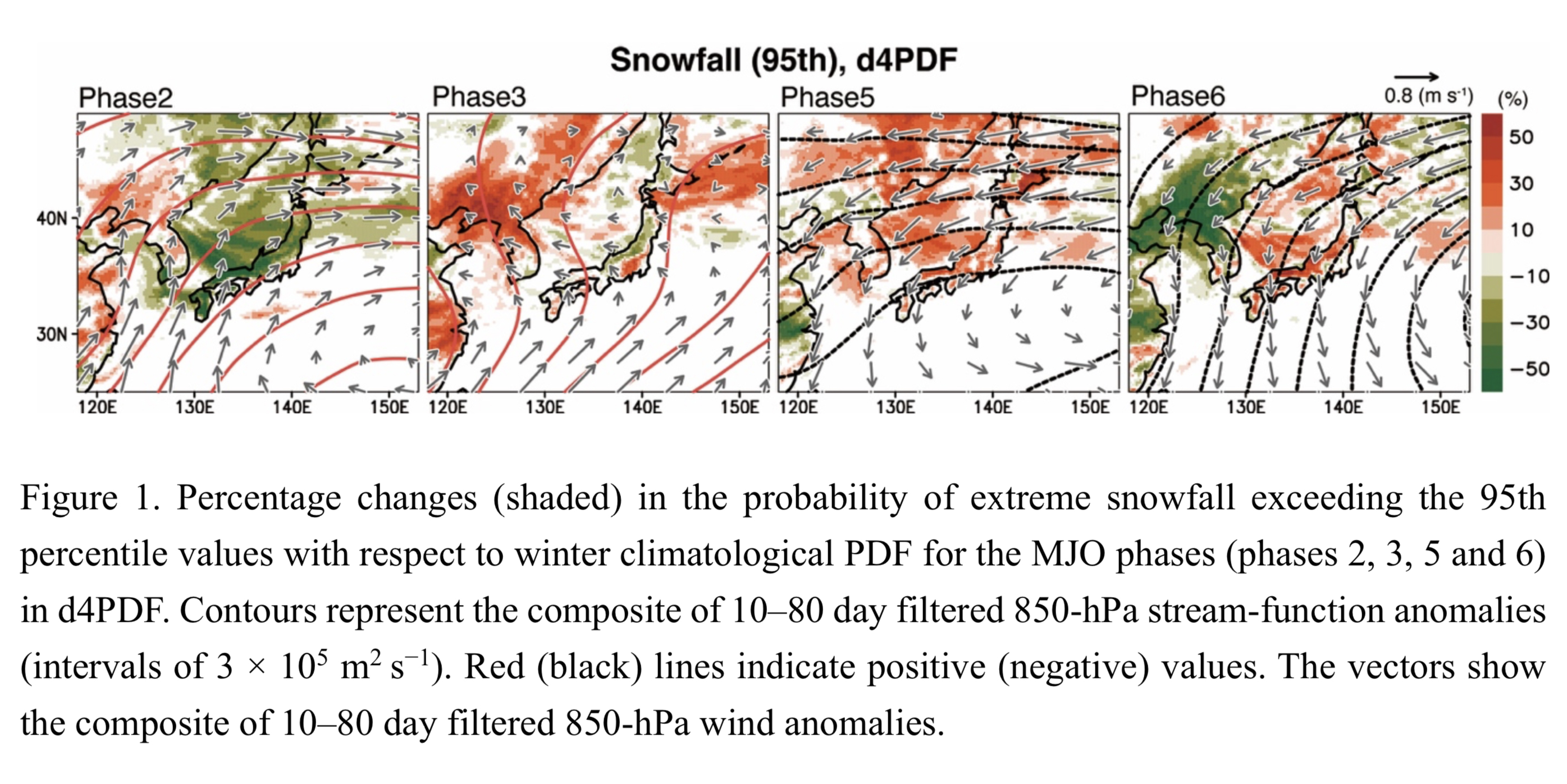
Plain Language Summary: The Madden-Julian Oscillation (MJO) is the most dominant mode of tropical intraseasonal variability and can modulate extratropical weather. Here, we investigate the influences of the MJO on the occurrence probability and spatial distribution of wintertime extreme snowfall and precipitation in Japan, which has not been clarified so far, based on a large-ensemble dataset of global and regional model simulations. The MJO significantly modulates the occurrence probability of extreme snowfalls on the Sea of Japan side and Kanto region and extreme precipitation on the Pacific Ocean side. We reveal the physical processes driving the extremes associated with the MJO. This study suggests that good representation in models and monitoring of the MJO help improve the predictability of wintertime extreme precipitation and snowfall in Japan.
Highlights:
- We could quantify and elucidate the geographical distribution of the probability of wintertime extreme snowfall and precipitation in Japan related to the MJO.
- The active MJO over the Maritime Continent and western Pacific intensifies cold air intrusion from Siberia into Japan associated with more frequent blocking over East Siberia, causing extreme snowfall in the Sea of Japan side.
- The Kanto extreme snowfall is partly attributable to cold air inflow from the MJO-induced blocking-type circulations.
- The active MJO convection over the Indian Ocean and west of the Maritime Continent stimulates the development of explosive south-coast cyclones due to enhanced moisture flux convergence, leading to extreme precipitation on the Pacific Ocean side and extreme snowfall in Kanto.
JMSJ, 2022, Vol. 100, No. 2 (April)
Article: Special Edition on Global Precipitation Measurement (GPM): 5th Anniversary
Tao et al. (2022)
Tao, W.-K., S. Lang, T. Iguchi, and Y. Song, 2022: Goddard latent heating retrieval algorithm for TRMM and GPM. J. Meteor. Soc. Japan, 100, 293 - 320.
Special Edition on Global Precipitation Measurement (GPM): 5th Anniversary,
https://doi.org/10.2151/jmsj.2022-015
Graphical Abstract
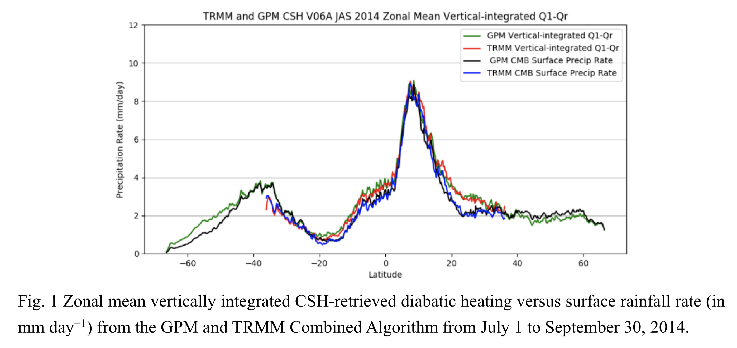
Plain Language Summary: The Goddard Convective-Stratiform Heating (CSH) algorithm has been developed to retrieve latent heating (LH), i.e., energy release or absorption through a phase change between water vapor and cloud in the atmosphere, in support of the Tropical Rainfall Measuring Mission (TRMM) and Global Precipitation Measurement (GPM) missions. Since LH cannot be measured directly with current measurement techniques, numerical model simulations resolving clouds are used to examine the relationships between latent heating and rainfall, which is easily measurable. This paper describes the current version6 of CSH and its differences/similarities versus the previous version5 of CSH. Long-term CRM simulations were conducted to identify the impact of the differences in the CRM settings for the versions 5 and 6 on LH structure/profiles.
Highlights:
- These are the two major differences (convective and stratiform separation method and model resolution) in GCE model simulations for the current V6 CSH and the previous V5 CSH. The GCE-simulated total heat source profile and its convective and stratiform component are almost identical for two different model resolutions (1000 and 200 m) using the same convective- stratiform separation method. However, The GCE-simulated vertical profile of heating source in the convective and stratiform region is sensitive to the convective-stratiform separation method.
- The CSH three-month and zonal mean equivalent surface rain rates are in good agreement with the Combined rain rates over the Inter Tropical Convergence Zone region; the agreement is best over the ocean. CSH three-month and zonal mean equivalent surface rain rates are larger than the Combined rain rates over land in both the tropics and subtropics. The net result is that V6 has significantly reduced biases over nearly every latitude compared to V5 and is therefore, in much better overall heat balance.
Article
Ito (2022)
Ito, K., 2022: Bias in near-real-time global sea surface temperature analysis of Japan Meteorological Agency associated with tropical cyclone passages in western North Pacific. J. Meteor. Soc. Japan, 100, 321 - 341.
https://doi.org/10.2151/jmsj.2022-016
Graphical Abstract
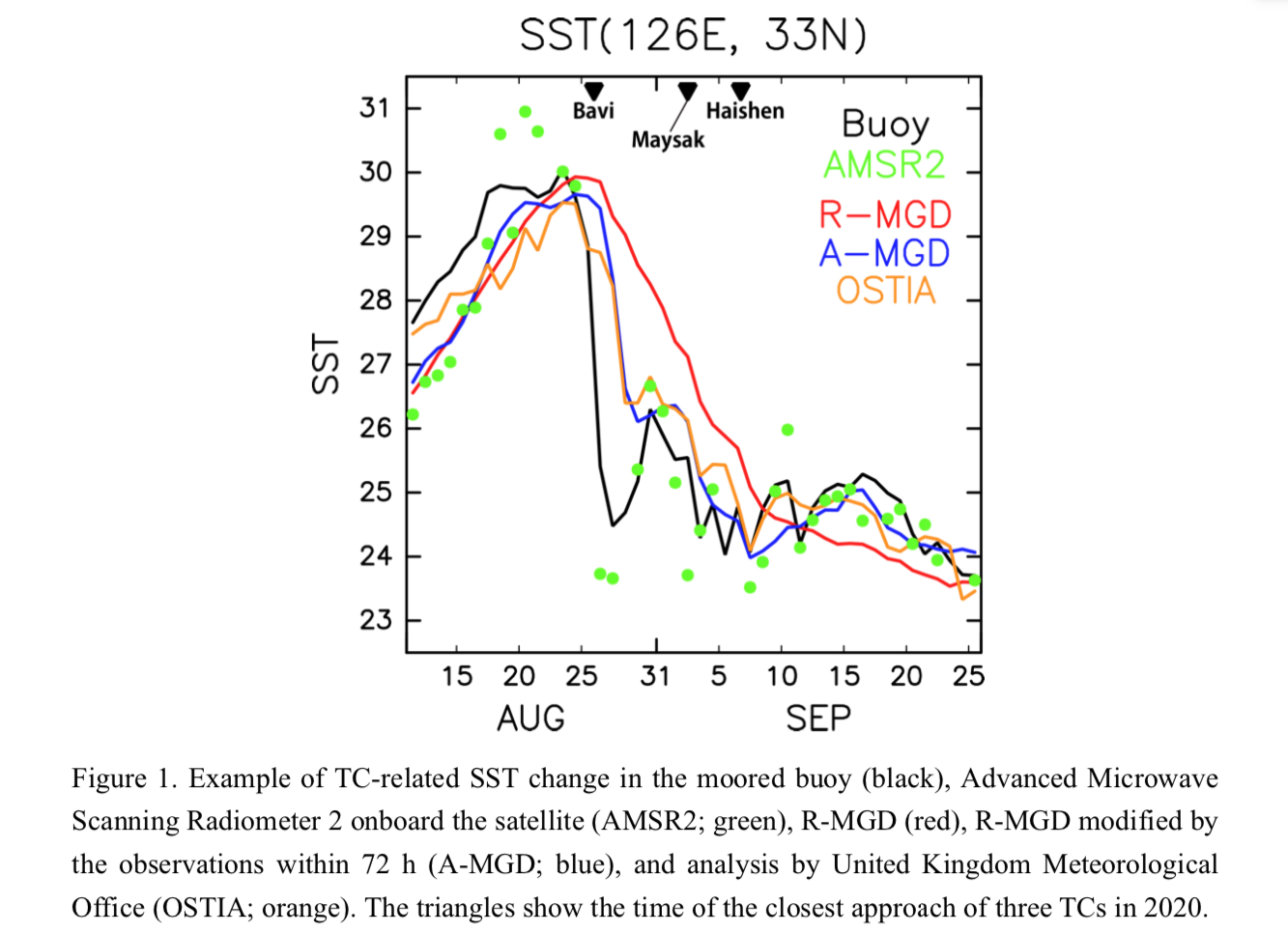
Plain Language Summary: The near-real-time merged satellite and in-situ data global sea surface temperature (SST) of the Japan Meteorological Agency (hereafter, R-MGD) is subjected to the exceeding filtering of short-time-scale fluctuations. Therefore, the rapid SST change due to the passage of tropical cyclones (TCs) causes biases. The issue can be alleviated by putting more weight on the observations within 72 h.
Highlights:
- Bias in R-MGD associated with the passage of TCs is qualitatively analyzed.
- Statistically significant biases range between -1 day and 4 days for positive biases and between +7 days and +14 days for negative biases within 500 km relative to the TC approach. The magnitude of positive SST biases is largely associated with cold subsurface water and intense TCs.
- The issue can be alleviated by putting more weight on the observations within 72 h through additional optimal interpolation. It also impacts on the intensity forecast of a succeeding TC.
Article
Ishijima et al. (2022)
Ishijima, K., K. Tsuboi, H. Matsueda, T. Y. Tanaka, T. Maki, T. Nakamura, Y. Niwa, and S. Hirao, 2022: Understanding temporal variations of atmospheric radon-222 around Japan using model simulations. J. Meteor. Soc. Japan, 100, 343-359.
https://doi.org/10.2151/jmsj.2022-017
Graphical Abstract
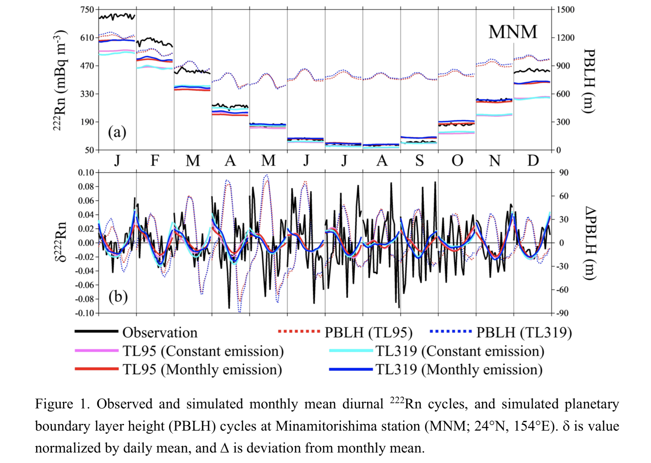
Plain Language Summary: Temporal variations of atmospheric radon-222 (222Rn) concentrations observed at four stations in Japan were analyzed for the monthly and diurnal variations, and a series of synoptic scale high-222Rn events using an on-line transport model. A new calculation approach using hourly 222Rn values normalized to daily means enabled to extract diurnal cycles from highly variable 222Rn values in winter due to sporadic continental 222Rn outflows.
Highlights:
- Diurnal cycles of absolute 222Rn concentrations observed and simulated are negligible or unclear, whereas d222Rn in November–March indicate clear diurnal cycles with notable daytime minima, mostly corresponding to PBLH maxima. At MNM, local 222Rn sources are not significant, and in model emissions around the station are also negligibly small.
- These results suggest that variations of 222Rn concentrations in the near-surface atmosphere over the stations, which has been transported from the continental sources, are controlled by diurnal variations of the local PBLH.
Article
Patra et al. (2022)
Patra, P. K., E. J. Dlugokencky, J. W. Elkins, G. S. Dutton, Y. Tohjima, M. Sasakawa, A. Ito, R. F. Weiss, M. Manizza, P. B. Krummel, R. G. Prinn, S. O'Doherty, D. Bianchi, C. Nevison, E. Solazzo, H. Lee, S. Joo, E. A. Kort, S. Maity, and M. Takigawa, 2022: Forward and inverse modelling of atmospheric nitrous oxide using MIROC4-atmospheric chemistry-transport model. J. Meteor. Soc. Japan, 100, 361-386.
https://doi.org/10.2151/jmsj.2022-018.
Graphical Abstract
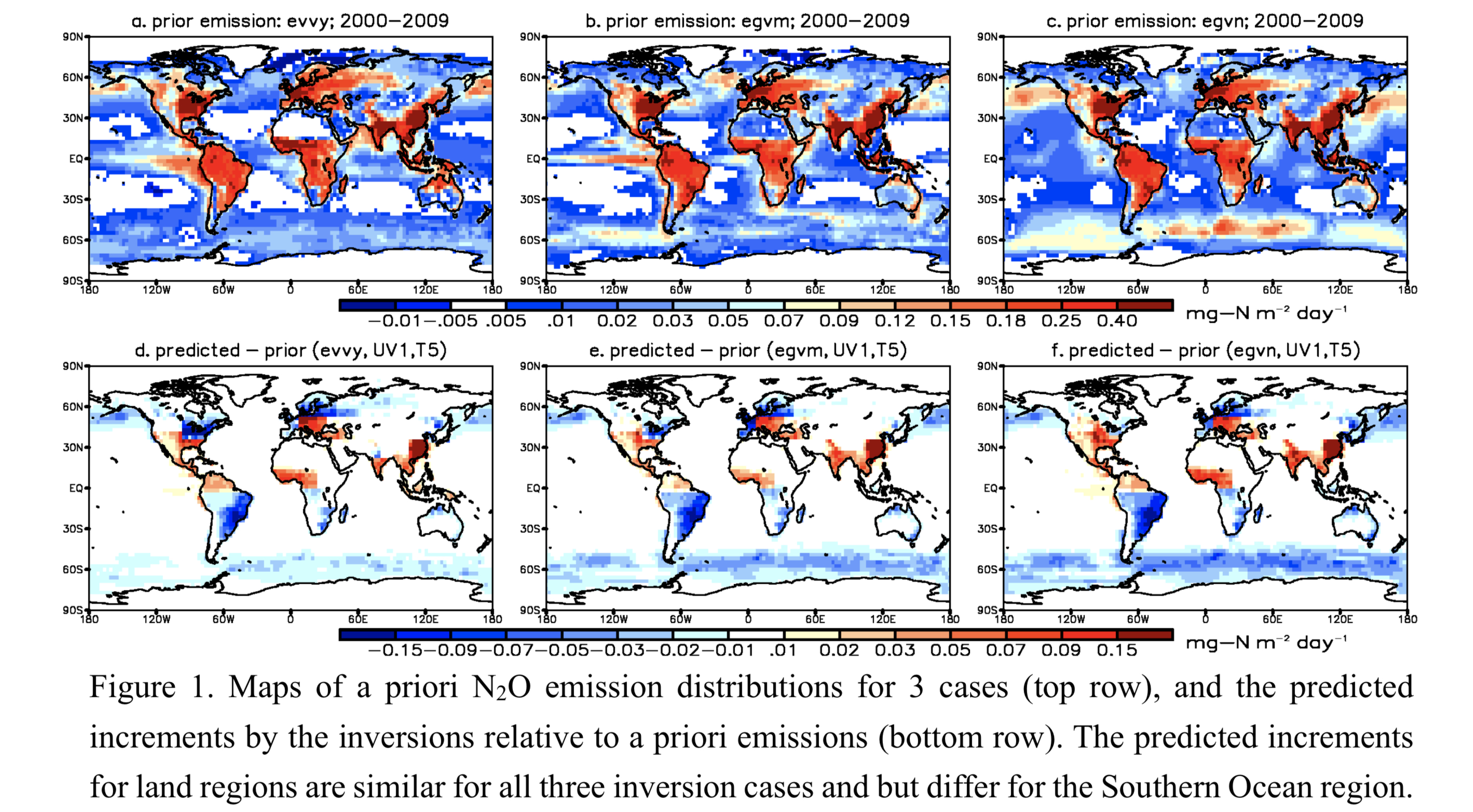
Plain Language Summary: Atmospheric nitrous oxide (N2O) contributes to global warming and stratospheric ozone depletion. Here we aim to better estimate the global and regional N2O emissions from different sources using high-quality atmospheric observations, JAMSTEC’s atmospheric chemistry-transport model (MIROC4-ACTM) and known (a priori) N2O emissions due to natural soil, agricultural land, other human activities and sea-air exchange. Regional N2O emissions are optimised by Bayesian inverse modelling for 84 partitions of the globe at monthly intervals for the period 1997- 2019. Our best estimate global land and ocean emissions are 14.30±0.20 and 2.91±0.27 TgN yr-1, respectively, for 2010-2019 (2010s), corresponding to N2O lifetime of about 127 yr.
Highlights:
- Global land and ocean emission variabilities show significant correlation with El Niño Southern Oscillation (ENSO). Global land emissions increased by 10% in 2010s from 13 TgN yr-1 in 2000s.
- The most recent ocean emission estimation (Fig. 1a), with lower emissions in the Southern Ocean regions, fits better with that predicted by the inversions, i.e., lower increments (Fig. 1d).
- Regional land emissions show increases over much of the America, Central Africa, and Asia regions between the 2000s and 2010s. Only Europe and Japan recorded a slight decrease in N2O emissions.
Article: Special Edition on Typhoons in 2018–2019
Wada et al. (2022)
Wada, A., W. Yanase, and K. Okamoto, 2022: Interactions between a tropical cyclone and upper-tropospheric cold-core lows simulated by an atmosphere-wave-ocean coupled model: A case study of Typhoon Jongdari (2018). J. Meteor. Soc. Japan, 100, 387-414.
Special Edition on Typhoons in 2018–2019,
https://doi.org/10.2151/jmsj.2022-019
Graphical Abstract
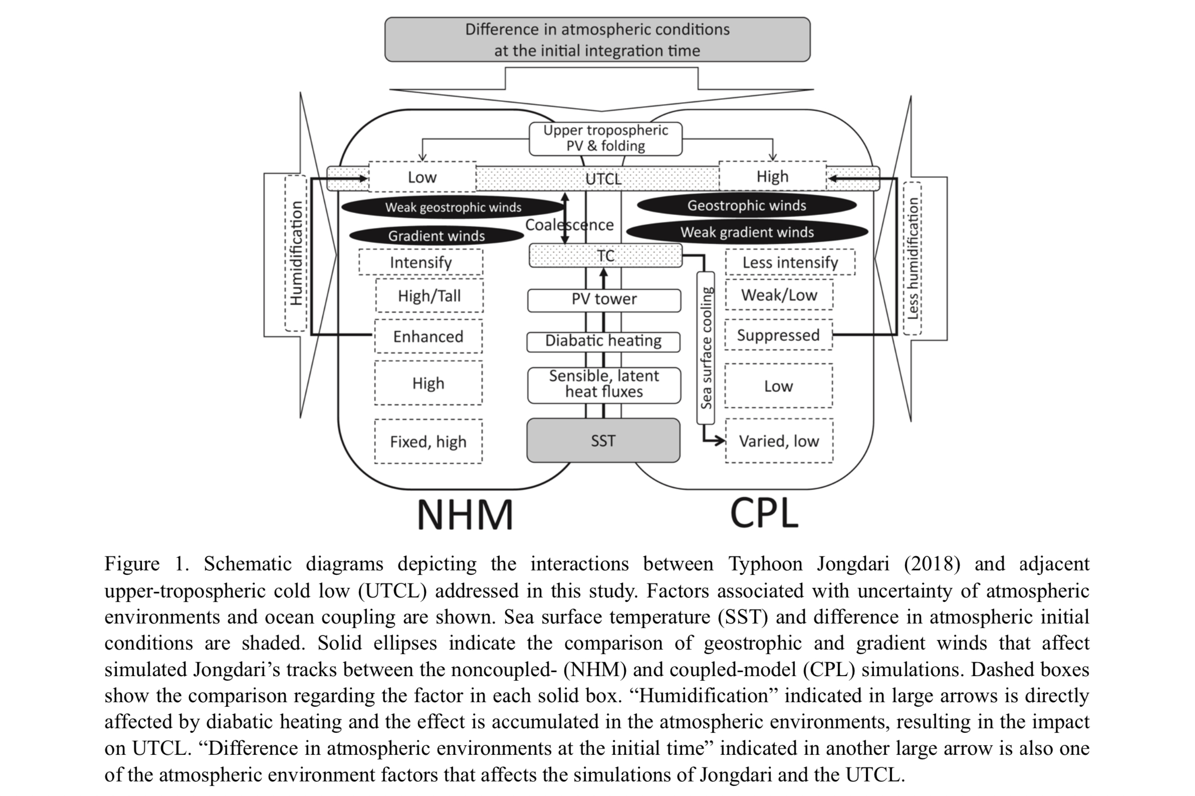
Plain Language Summary: To investigate the effects of atmosphere-ocean interactions and interactions between upper-tropospheric cold lows (UTCLs) and Typhoon Jongdari (2018) on the unusual Jongdari’s track, numerical simulations were conducted with a 3-km-mesh nonhydrostatic atmosphere model and an atmosphere-wave-ocean coupled model, using different initial conditions created by adopting different initial times. This study demonstrated the effects of ocean coupling and atmospheric initial conditions on the simulation of Jongdari and discussed their mechanism.
Highlights:
- Ocean coupling helped sustain the upper-tropospheric potential vorticity associated with adjacent upper-tropospheric cold low and weakened the column of elevated potential vorticity associated with Jongdari.
- A larger difference in the atmospheric initial conditions had a stronger influence on simulated track and intensity of both Jongdari and the upper-tropospheric cold low than the effects of ocean coupling.
- The steering flow of Jongdari was affected by the geostrophic-balanced cyclonic circulation created by the upper-tropospheric cold low.
Article
Hsu et al. (2022)
Hsu, W.-C., K. Kikuchi, H. Annamalai, and K. J. Richards, 2022: Assessing the representation of ISO- related ocean forcing in the tropics in atmospheric reanalyses. J. Meteor. Soc. Japan, 100, 415-435.
https://doi.org/10.2151/jmsj.2022-020
Graphical Abstract
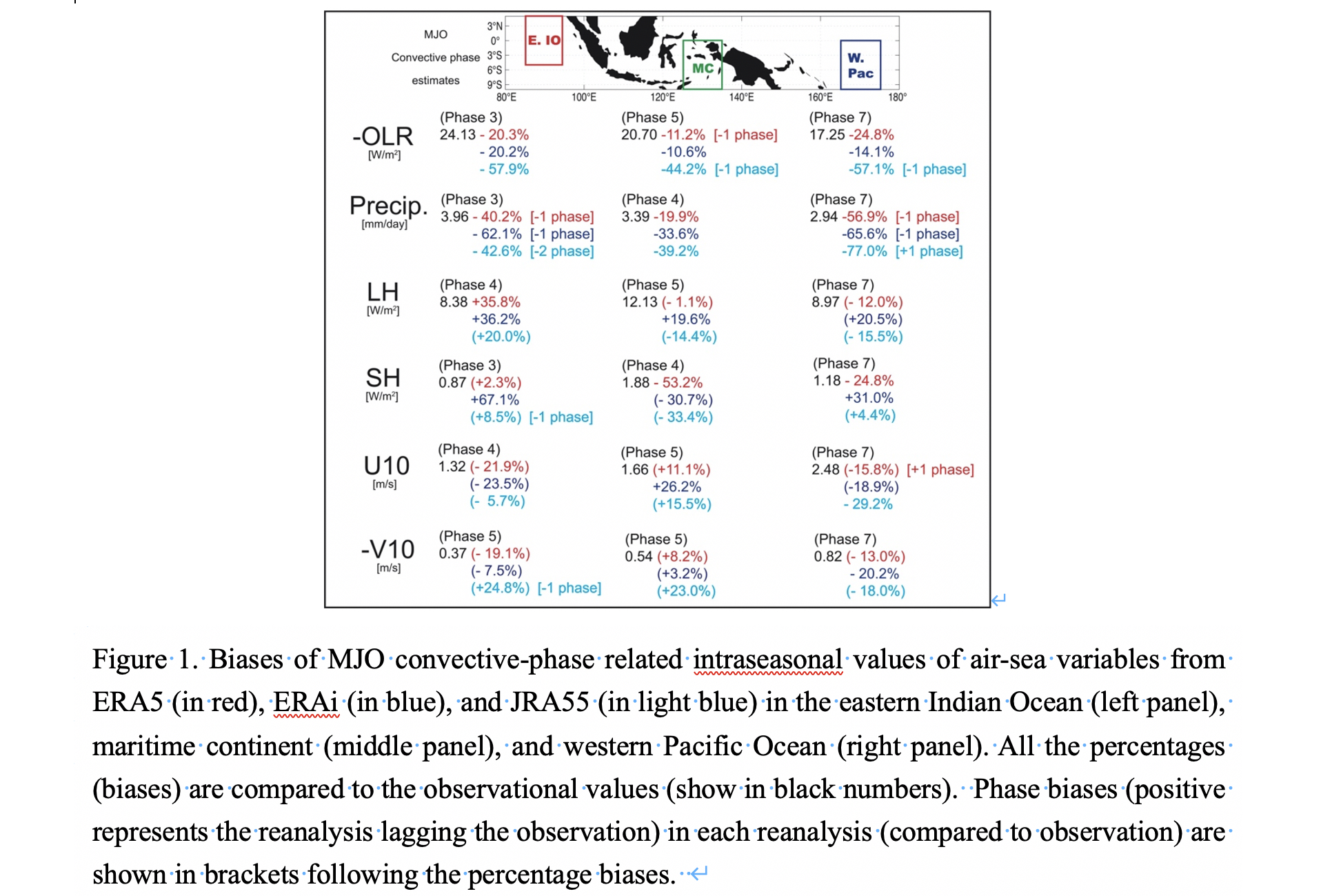
Plain Language Summary: The intraseasonal oscillation (ISO) is planetary-scale eastward propagating convective cloud clusters in the tropics with a period of about 30 to 90 days. To simulate and understand the ISO and the associated ocean responses, by using ocean models, realistic forcing data are required. By comparing three of the newest reanalysis datasets (ERA5, ERA-interim (ERAi), and JRA55), we show that they all have the common problem of underestimating rainfall related to ISO, while ERA5 shows the smallest bias. Our results suggest ERA5 as a relatively better forcing.
Highlights:
- The representation of ISO-related surface variables in three reanalyses were quantitatively assessed.
- JRA55 underestimates the outgoing longwave radiation by ~40 to 60% related to ISO.
- All the three reanalyses show large biases in ISO-related precipitation, while the biases in other ISO-associated variables are region- and season-dependent.
- ERA5 is shown as a relatively better ocean model forcing for ISO studies, since ERAi shows larger biases in magnitude while JRA55 shows larger phase biases of ISO-related variables.
Notes and Correspondence
Tohjima et al. (2022)
Tohjima, Y., Y. Niwa, K. Tsuboi, and K. Saito, 2022: Did Atmospheric CO2 and CH4 observation at Yonagunijima detect fossil-fuel CO2 reduction due to COVID-19 lockdown? J. Meteor. Soc. Japan, 100, 437-444.
https://doi.org/10.2151/jmsj.2022-021
Graphical Abstract
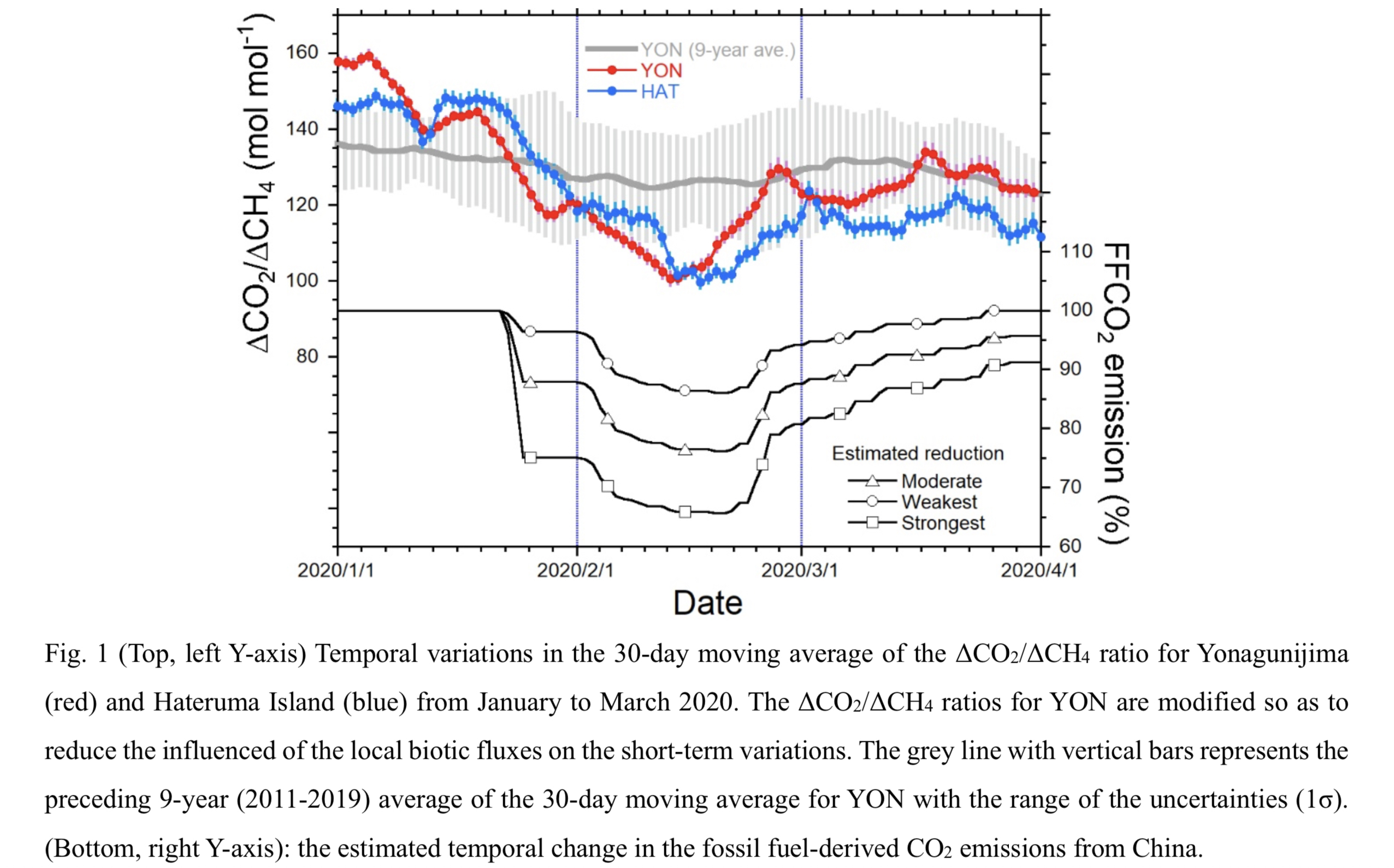
Plain Language Summary: Atmospheric observation at Yonagunijima is generally influenced by air masses from the Asian continent during winter because of the East Asian monsoon. The atmospheric carbon dioxide and methane observed at Yonagunijima during a period from January to March in 1998-2020 were analyzed. After the influences of the local biotic emissions on the short-term variability were reduced, the variability ratios (ΔCO2/ΔCH4) showed a marked decrease in February 2020 associated with the considerable reduction of the fossil fuel-derived CO2 emission in China presumably caused by the COVID-19 lockdown. This result convinced us that the variability ratio could be useful to investigate the relative emission changes in the upwind region.
Highlights:
- Monthly means of synoptic-scale variability ratios of the atmospheric CO2 and CH4 (ΔCO2/ΔCH4) observed at Yonagunijima, after influences of the local biotic fluxes on the short-term variations are reduced, well trace the changes in the relative emissions from the continental Asia.
- The ΔCO2/ΔCH4 ratio at Yonagunijima also showed a marked decrease associated with the COVID-19 lockdown in China in February 2020 as that at Hateruma Island, which is located to about 100 km east of Yonagunijima, did.
- Because Yonagunijima and Hateruma Island are located at the downwind side of the Asian continent that is the biggest CO2 emitter in the world, the atmospheric observations at both sites would continue to provide valid information on emission changes over the continent.
Article
Ishioka et al. (2022)
Ishioka, K., N. Yamamoto, and M. Fujita, 2022: A formulation of a three-dimensional spectral model for the primitive equations. J. Meteor. Soc. Japan, 100, 445-469.
https://doi.org/10.2151/jmsj.2022-022
Graphical Abstract
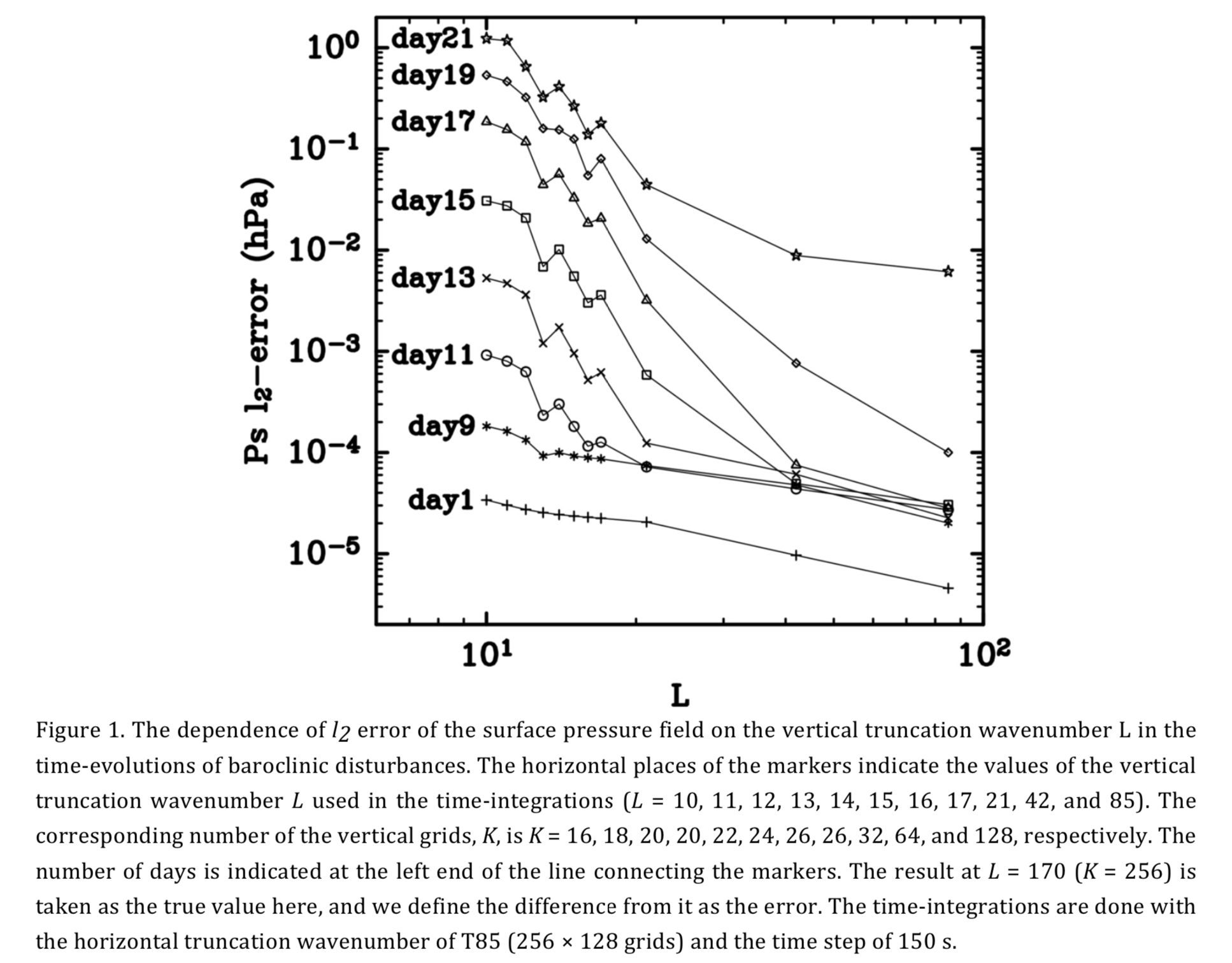
Plain Language Summary: A formulation of a three-dimensional spectral model based on the primitive equations is proposed. In this formulation, the Legendre polynomial expansion is used for the vertical discretization. By performing several calculations with different vertical degrees of freedom, a characteristic property of the spectral method is observed in which the error of the numerical solution decreases rapidly when the number of vertical degrees of freedom is increased.
Highlights:
- Semi-implicit time integration can be efficiently done under this formulation.
- This implementation of the primitive equations can give accurate numerical solutions with a relatively small degrees of freedom in the vertical discretization.
- An alternative to the sponge layer can be devised to suppress the reflected waves under this formulation.
JMSJ, 2022, Vol. 100, No. 3 (June)
Article
Siswanto et al. (2022)
Siswanto, G. van der Schrier, and B. van den Hurk, 2022: Observed increase of urban short duration rainfall extremes as surface temperature rise: The Jakarta case. J. Meteor. Soc. Japan, 100, 475-492.
https://doi.org/10.2151/jmsj.2022-023
Graphical Abstract
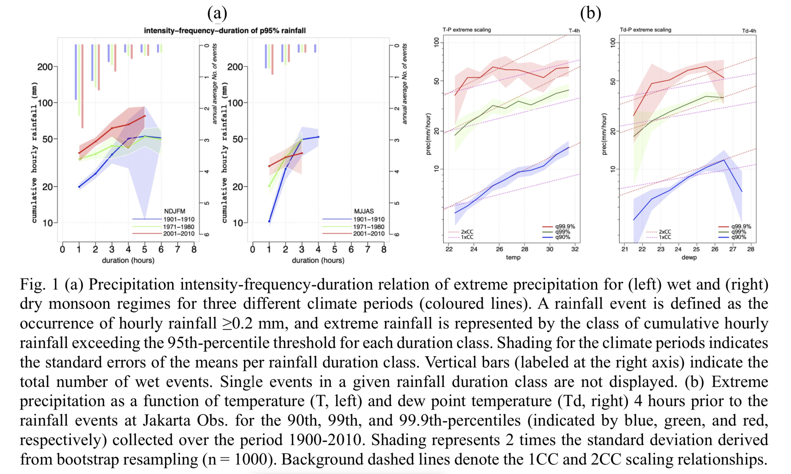
Plain Language Summary: Analysis of 81 years hourly rainfall of Jakarta Observatory between 1900 and 2010 indicate about doubling of the number of short-duration rainfall events in the wet season, with higher intensity in recent decades. Surface warming in the urbanized city accompanied by enhanced availability of moisture results in an increase in convective available potential energy, which contributes to enhanced intense precipitation. Super Clausius–Clapeyron scaling (CC) of high- intensity rainfall is attributed to high near-surface temperature and atmospheric moisture content in the morning. This super-CC scaling is present in a relatively small range of surface temperature values. Results of this study are in agreement with earlier findings exploring the intensification of extreme morning precipitation and a temporal shift of the diurnal convective maximum from late afternoon to late night/early morning in response to local warming.
Highlights:
- A significant frequency increase of about 25% in short duration (1–3 hours) rainfall events was observed in 2001–2010 compared to the start of the 20th century, and the cumulative rainfall amount related to these events has increased by 50%. The most intense rainfall events are getting shorter in duration.
- Surface warming in the urbanised city together with additional moisture availability resulting from large-scale atmospheric features in the lower atmosphere may result in warmer and more unstable air aloft, in particular in the mid-troposphere, implying a larger buoyancy into the mid-troposphere and larger and higher convective up- drafts.
- Increased atmospheric moisture in the early morning may promote 2CC temperature scaling triggering strong morning rainfall events, while 1CC temperature scaling is found for less extreme rainfall events.
Article
Islam et al. (2022)
Islam, M. R., M. Satoh, and H. Takagi 2022: Tropical cyclones affecting Japan central coast and changing storm surge hazard since 1980. J. Meteor. Soc. Japan, 100, 493-507.
https://doi.org/10.2151/jmsj.2022-024
Graphical Abstract
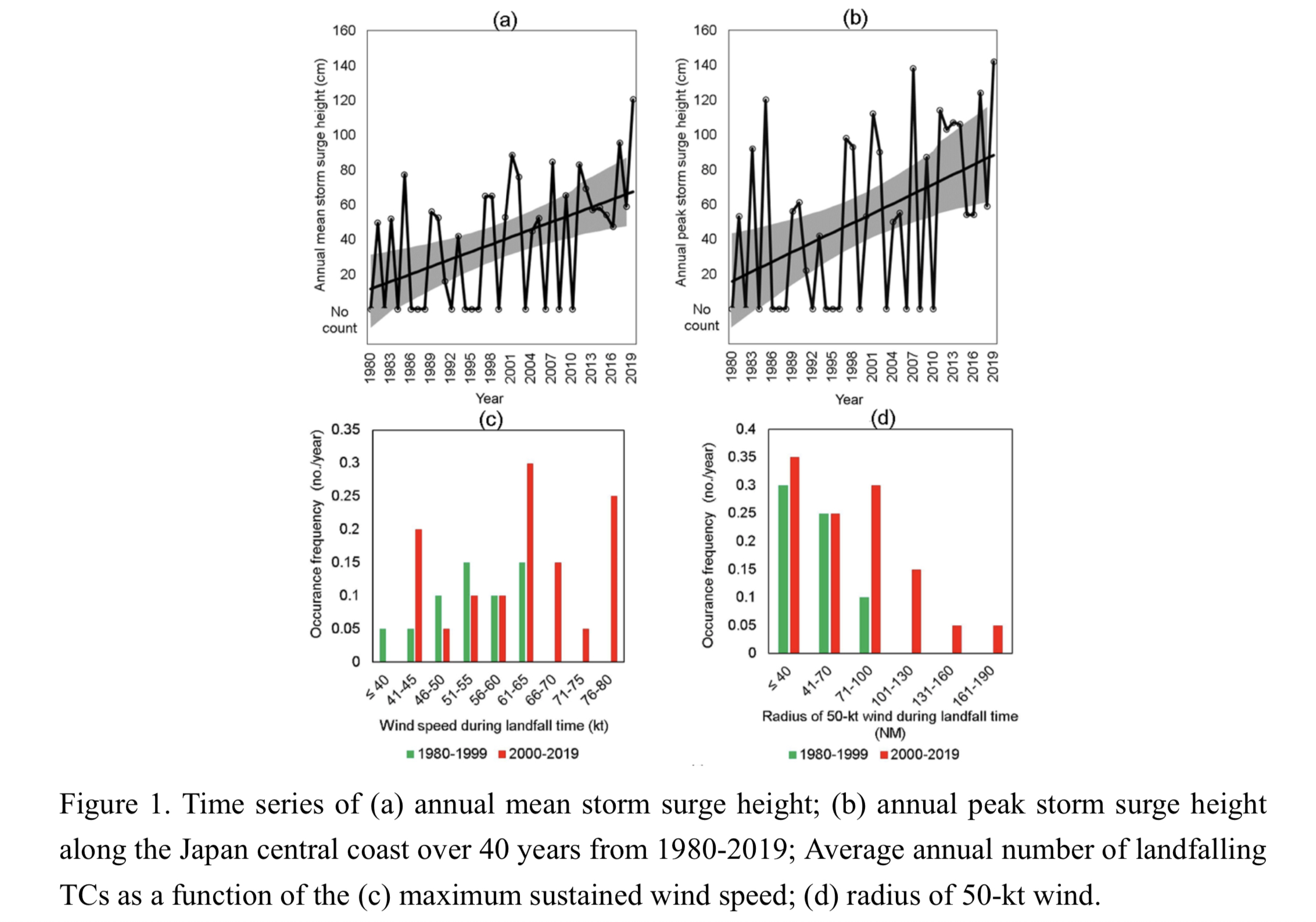
Plain Language Summary: This study investigated tidal records and landfall tropical cyclone (TC) best tracks from 1980 to 2019 to determine changes in storm surge heights in coastal regions of Central Japan, including Tokyo. The results indicate that annual mean storm surge heights have increased in the last 20 years (2000–2019) compared to those in 1980–1999, and that these changes are noteworthy, particularly in Tokyo Bay. TC wind intensity and size during landfall time frame have become stronger and larger, respectively, corresponding to increasing storm surge magnitudes.
Highlights:
- A highly significant increase in storm surge height of +41% occurred per decade from 1980 to 2019.
- A positive correlation between surge heights and storm surge hazard potential index (SSHPI) suggests that the changes in TC intensity during landfall time frame have played the most significant role in the increase of surge magnitudes, followed by changes in TC size.
- Also, the increased occurrence frequency of TCs with more northeastward tracks is another factor that may have contributed to the increased surge hazards around Tokyo.
Article
Mogi and Watanabe (2022)
Mogi, A., and M. Watanabe, 2022: Qualifying contributions of teleconnection patterns to extremely hot summers in Japan. J. Meteor. Soc. Japan, 100,
https://doi.org/10.2151/jmsj.2022-025
Graphical Abstract
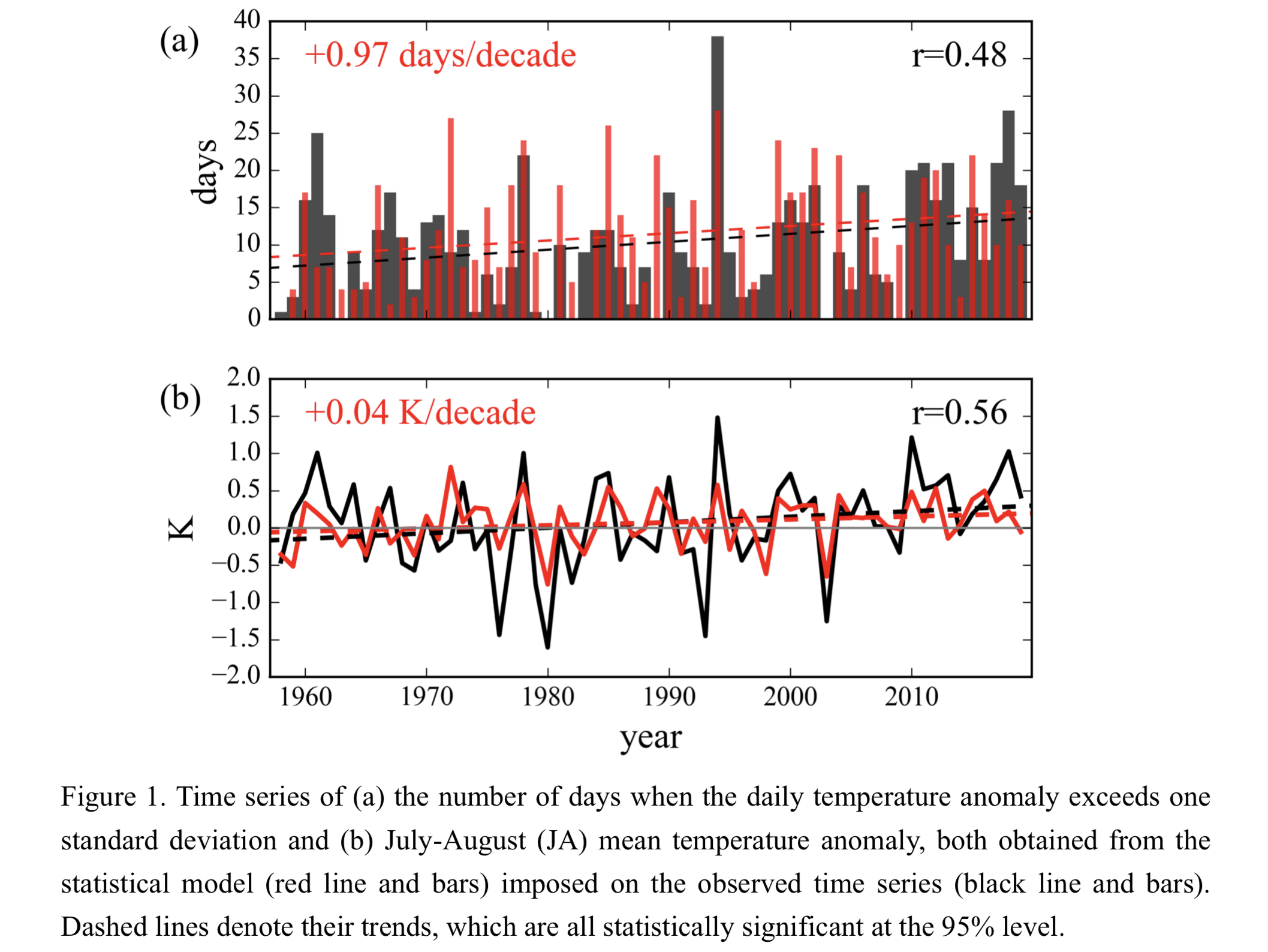
Plain Language Summary: Severe high-temperature anomalies in Japan are often accompanied by three teleconnection patterns. This study examined the effects of the three major teleconnection patterns on the temperature anomalies in July and August with a statistical model. The model shows that they together accounted for half of the total variance of the temperature anomaly for extremely hot summers, to which each of the three teleconnection patterns have a similar degree of contribution.
Highlights:
- The contribution of teleconnection patterns to temperature anomalies is quantified.
- On the daily time scale, the three patterns contribute equally; on the interannual variability, the Pacific-Japan pattern with the longest time scale contributes the most.
- An increasing trend in the circumglobal teleconnection pattern index is suggested to be a factor to explain the long-term increase in the heat wave frequency in Japan.
Article
Mizuta et al. (2022)
Mizuta, R., M. Nosaka, T. Nakegawa, H. Endo, S. Kusunoki, A. Murata, and I. Takayabu, 2022: Extreme precipitation in 150-year continuous simulations by 20-km and 60-km atmospheric general circulation models with dynamical downscaling over Japan by a 20-km regional climate model. J. Meteor. Soc. Japan, 100,
https://doi.org/10.2151/jmsj.2022-026
Graphical Abstract
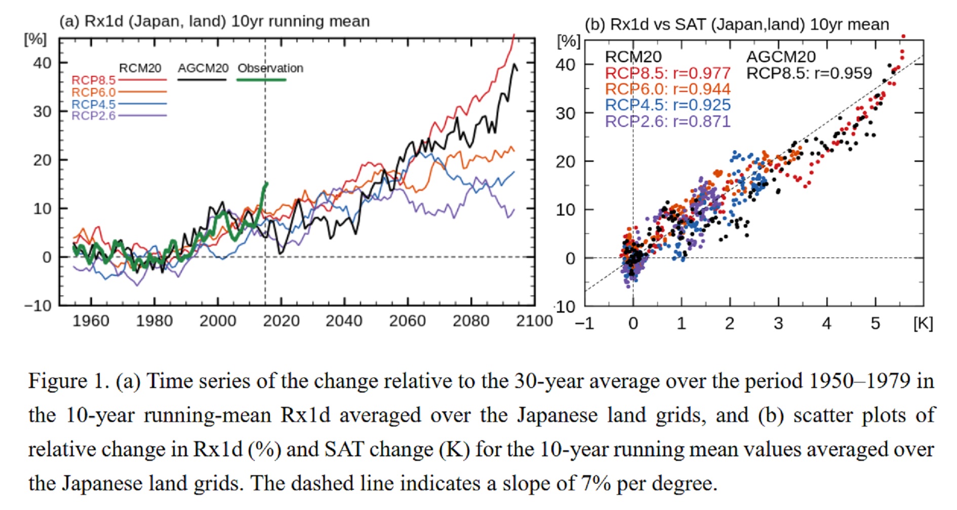
Plain Language Summary: Continuous simulations from the middle of the 20th century to the end of the 21st century were performed using a high-resolution atmospheric global climate model with dynamical downscaling using a regional climate model over the region around Japan. Regardless of the emission scenario used, the global-mean relative increase in annual maximum daily precipitation (Rx1d) was roughly proportional to the increase in the global-mean surface air temperature (SAT). A similar correlation between Rx1d and SAT was seen also in the values averaged over the Japanese land area in the 20-km simulations after applying a 10-year running mean.
Highlights:
- 150-year simulation with 20-km models allow us to analyze transitional changes caused by global warming in phenomena that require high-resolution simulations, such as extreme precipitation events.
- The models simulate the observed recent increase in Rx1d averaged over the Japanese land area.
- A clear correlation between Rx1d and SAT averaged over the Japanese land area is seen in the 20-km AGCM and the 20-km RCM future simulations.
Article
Tsuyuki and Tamura (2022)
Tsuyuki, T., and R. Tamura, 2022: Nonlinear data assimilation by deep learning embedded in an ensemble Kalman filter. J. Meteor. Soc. Japan, 100,
https://doi.org/10.2151/jmsj.2022-027
Graphical Abstract
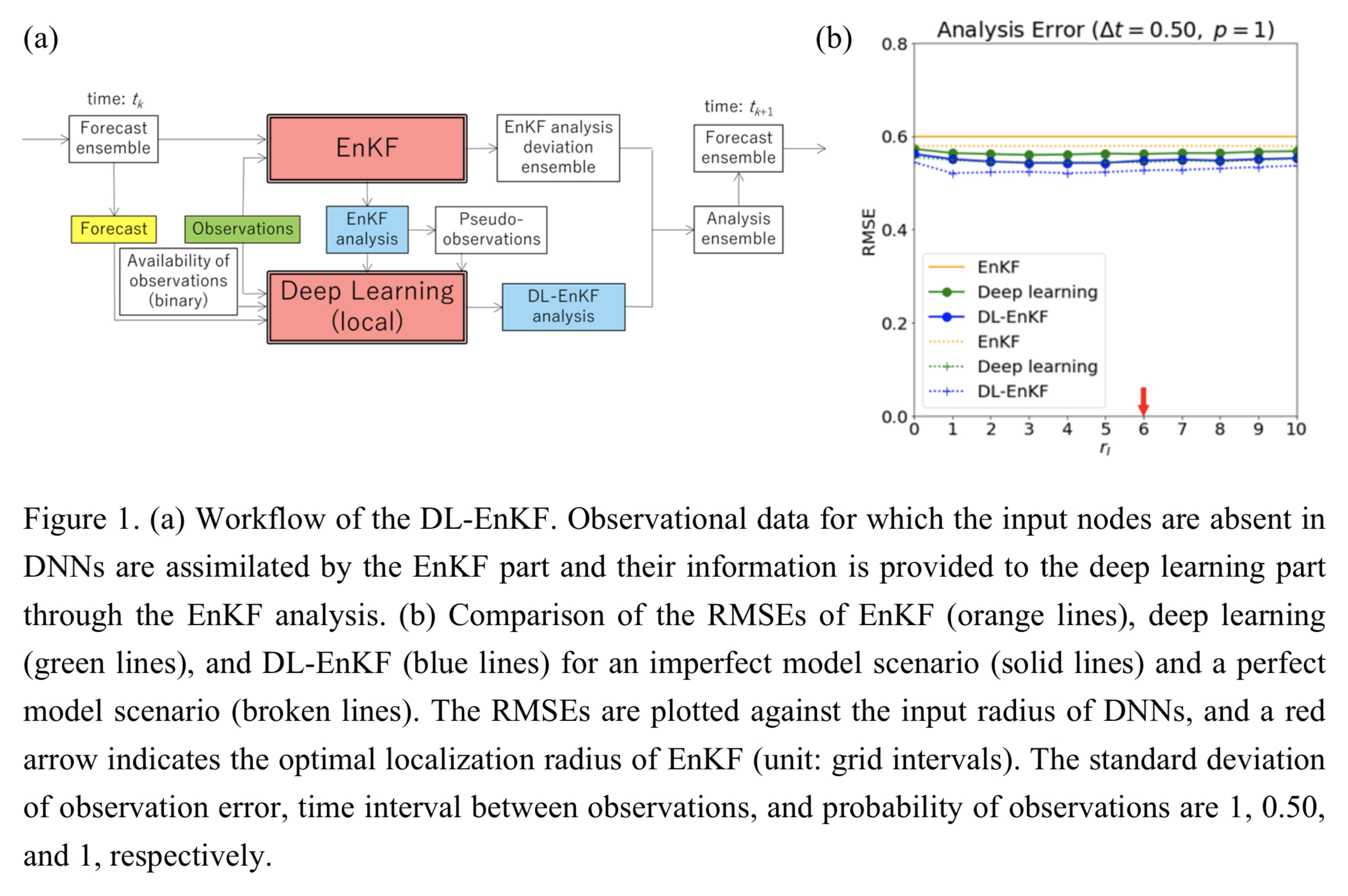
Plain Language Summary: As an alternative to the particle filter for high-dimensional systems, a nonlinear data assimilation method based on deep learning is proposed, in which deep neural networks (DNNs) are locally embedded in the ensemble Kalman filter (EnKF). This method is named the deep learning-ensemble Kalman filter (DL-EnKF). Results of data assimilation experiments using three versions of the Lorenz 96 model and an EnKF with a small ensemble show that the DL-EnKF is superior to the EnKF in terms of accuracy in strongly nonlinear regimes.
Highlights:
- The DL-EnKF analysis is more accurate than the output of deep learning because of positive feedback in assimilation cycles.
- Even if the target of training is an EnKF analysis with a large ensemble or a simulation by an imperfect model, the improvement introduced by the DL-EnKF is not very different from the case where the target of training is the true state.
- The inclusion of EnKF analysis in the inputs of DNNs not only improves the accuracy of deep learning but also reduces the optimal number of nodes per hidden layer and the dependence of the accuracy on the input radius.
Article
Hsieh et al. (2022)
Hsieh, M.-K., Y.-W. Chen, Y.-C. Chen, and C.-M. Wu, 2022: The roles of local circulation and boundary layer development in tracer transport over complex topography in central Taiwan. J. Meteor. Soc. Japan, 99, 555-573.
https://doi.org/10.2151/jmsj.2022-028
Graphical Abstract
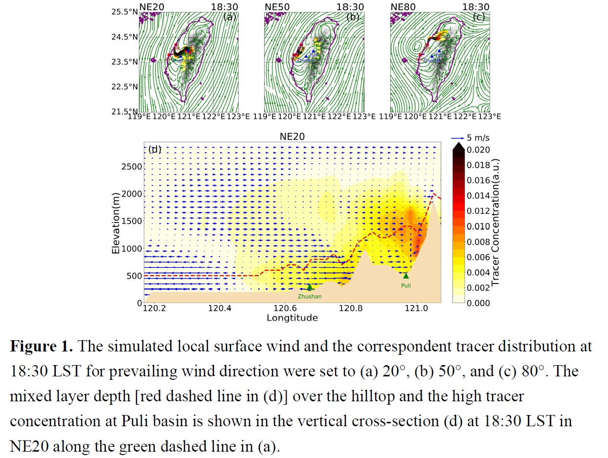
Plain Language Summary: The PM2.5 concentration tends to be high in central Taiwan under northeasterly monsoon. We examine the essential pollutant transport and accumulation mechanism in central Taiwan by conducting high-resolution idealized tracer transport TaiwanVVM simulations. We conclude that the lee vortex, which is induced by the blocking effect of the Central Mountain Range of Taiwan to the northeasterly monsoon, controls the tracer transport in the plain areas of central Taiwan. Once the pollutant is transported to the mountain areas, the diurnal variation of the boundary layer development over complex topography could further decide the nighttime local pollutant concentration in the Puli basin.
Highlights:
- Under northeasterly due east (due north) environment, the pollutant transported from the southern source (northern source) at the coastal area of central Taiwan are most likely to induce high concentrations in Puli at night.
- The slight change in the wind direction of the northeasterly monsoon (from 20° to 80°) and the emission site locations (40 km along the coastline) could result in a sharp difference in the pollutant transport scenarios.
- The thinning of mixed-layer depth in the evening prevents the pollutant from being transported across the hilltops around the Puli basin and results in a high pollutant concentration at night.
Article
Li et al. (2022)
Li, J., F. Ren, C. Ding, Z. Jia, M. Wang, Y. Chen, and T. Feng, 2022: Improvement of the ensemble methods in the dynamical–statistical–analog ensemble forecast model for landfalling typhoon precipitation. J. Meteor. Soc. Japan, 100, 575-592.
https://doi.org/10.2151/jmsj.2022-029.
Graphical Abstract
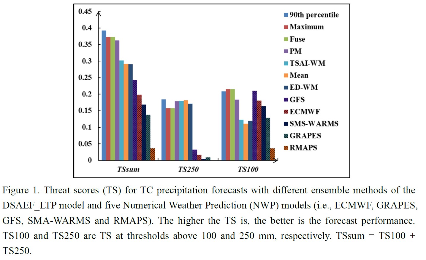
Plain Language Summary: The Dynamical–Statistical–Analog Ensemble Forecast model for landfalling typhoon precipitation (the DSAEF_LTP model) identifies tropical cyclones (TCs) similar to the target TC and then assembles the precipitation of them to get the precipitation forecast for the target TC. Two original ensemble methods in the DSAEF_LTP model, namely, mean and maximum, tend to under- and over- forecast TC precipitation, respectively. To improve the forecast performance of the DSAEF_LTP model, the following five new ensemble methods are incorporated: optimal percentile, fuse, probability-matching mean (PM), equal difference-weighted mean (ED-WM), and TC track Similarity Area Index-weighted mean (TSAI-WM). Experiments show that the overall performance of the optimal percentile (the 90th percentile) ensemble method is superior.
Highlights:
- The 90th percentile ensemble method performs best in TC precipitation forecasts of the DSAEF_LTP model.
- Compared with the five NWP models, the DSAEF_LTP model with the new ensemble methods performances better.
- The forecast performance of the DSAEF_LTP model can be further improved by applying different ensemble methods to TCs with different track types.
JMSJ, 2022, Vol. 100, No. 4 (August)
Article
Nakamura et al. (2022)
Nakamura, S., H. Kusaka, R. Sato, and T. Sato, 2022: Heatstroke risk projection in Japan under current and near future climates. J. Meteor. Soc. Japan, 100, 597-615.
https://doi.org/10.2151/jmsj.2022-030
Graphical Abstract
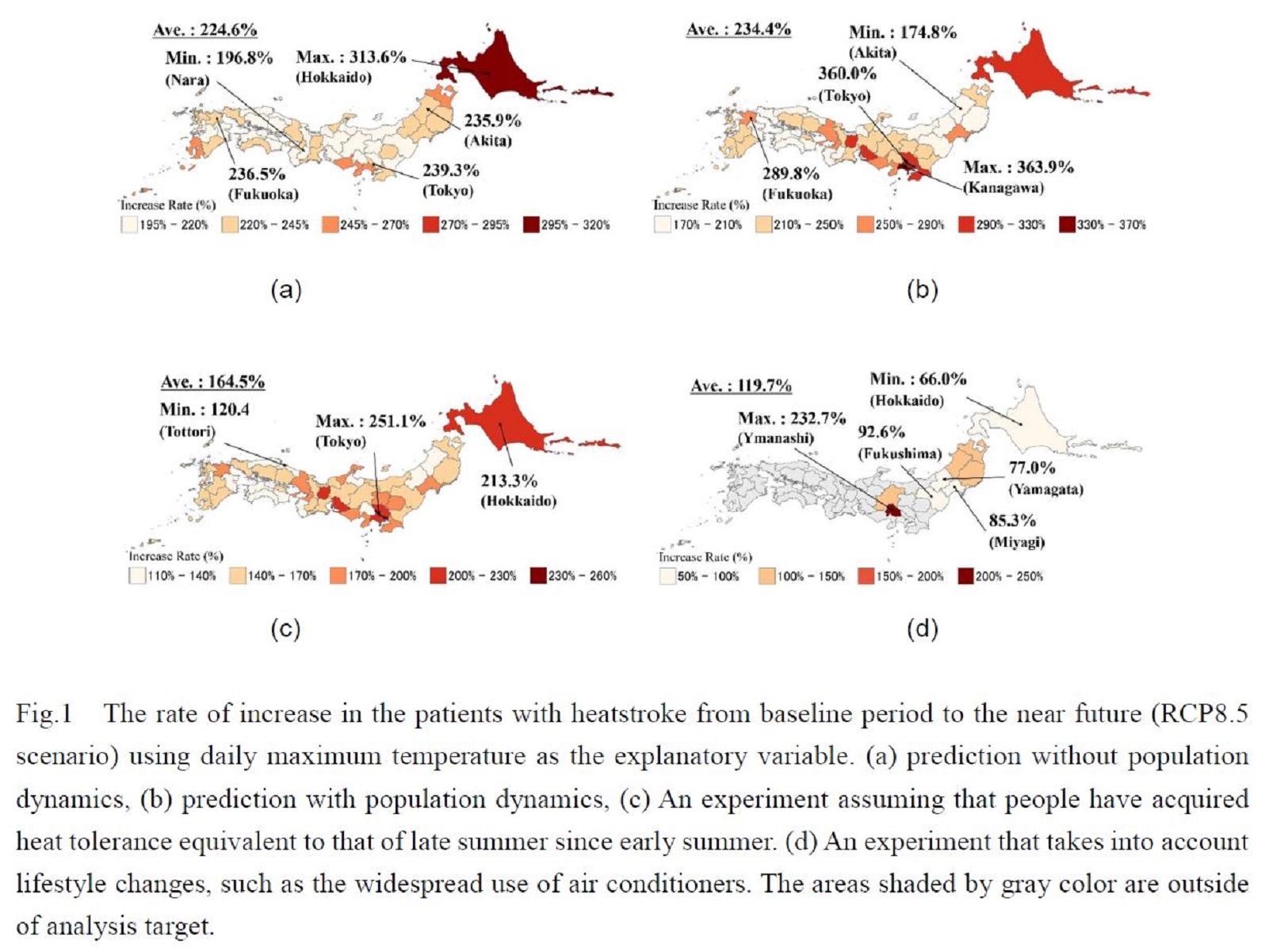
Plain Language Summary: In this study, a generalized linear model was used to predict the number of heatstroke emergencies in the near future (2031-2050). The results showed that the rate of increase in the number of heatstroke emergencies from the baseline (1981-2000) to the near future was about 2.6 times (considering climate change and population dynamics). We also examined the extent to which the number of heatstroke emergencies could be reduced by taking into account the acquisition of heat tolerance and changes in lifestyle.
Highlights:
- In this study, we used a statistical model (GLM) that takes into account heat acclimatization throughout the summer to predict the number of emergency heatstroke near future (2031-2050).
- The risk of heatstroke from the residents' perspective will increase about 2.2 times on average nationwide from the baseline (1981-2000) to near future (2031-2050).
- The risk of heatstroke from the administrative perspective will increase by a factor of 2.3 on average from the baseline to the near future.
- There is much room for risk control in cold regions by promoting the acquisition of heat tolerance and lifestyle changes.
Article: Special Edition on Typhoons in 2018-2019
Fudeyasu et al. (2022)
Fudeyasu, H., U. Shimada, Y. Oikawa, H. Eito, A. Wada, R. Yoshida, and T. Horinouchi, 2022: Contributions of the large-scale environment to the typhoon genesis of Faxai (2019). J. Meteor. Soc. Japan, 100, 617-630.
Special Edition on Typhoons in 2018-2019
https://doi.org/10.2151/jmsj.2022-031.
Graphical Abstract
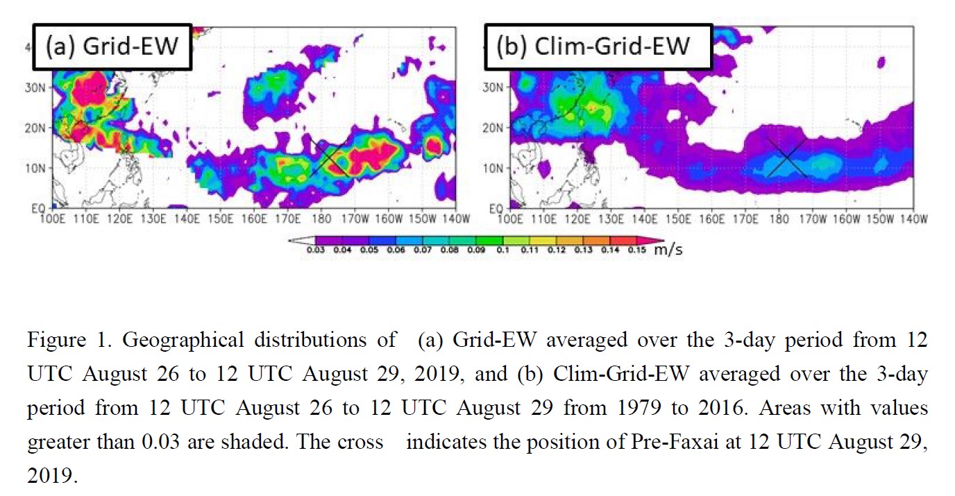
Plain Language Summary: This study investigated the atmospheric and oceanic contributions to the genesis of Typhoon Faxai in 2019. Statistical analysis, the Tropical Cyclone genesis Score (TGS) and Typhoon Intensity Forecast Scheme (TIFS) detected the tropical disturbance that developed into Faxai 10 days before the typhoon arose, an indication that monitoring environmental factors such as easterly waves and vertical wind shear are important for disaster prevention.
Highlights:
- The score evaluated by a grid version of the TGS averaged around the occurrence of Faxai was approximately twice as large as the climatological mean. It was the second largest value in the past 38 years.
- The Faxai area with high scores could be traced back to the eastern North Pacific around August 25, 2019.
- The Faxai area with high scores moved westward because of the background easterly flow over the eastern North Pacific, then entered the western North Pacific.
- The TIFS showed that the important environments for its genesis were ocean conditions and the vertical wind shear. The oceanic conditions contributed to the development of Faxai as it traveled over the western North Pacific.
Article
Ose et al. (2022)
Ose, T., H. Endo, Y. Takaya, S. Maeda, T. Nakaegawa, 2022: Robust and uncertain sea-level pressure patterns over summertime east Asia in the CMIP6 multi-model future projections. J. Meteor. Soc. Japan, 100, 631-645.
https://doi.org/10.2151/jmsj.2022-032
Graphical Abstract
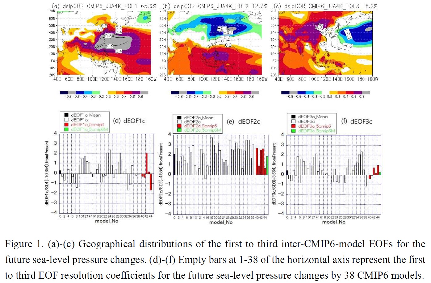
Plain Language Summary: Robust and uncertain sea-level pressure patterns over summertime East Asia in the future global warming projections and their causes are studied by applying the inter-model empirical orthogonal function (EOF) analysis in the sixth phase of the Coupled Model Intercomparison Project (CMIP6) and focusing common features with the previous CMIP5 analysis.
Highlights:
- A robust future projection pattern making positive contributions to almost all the CMIP6 future pressure changes (Fig. 1b and Fig. 1e), represents a weakened high-pressure system in northern East Asia and is understood as the result of surface warming over the northern continents.
- For two uncertain (but major) patterns in the ensemble projections (Fig. 1a and c), the signs of their contributions to the future changes are dependent on the model used (Fig.1d and f). They represent a high-pressure system in subtropical East Asia and the anomaly of the climatological pressure pattern over summertime East Asia, respectively.
- The two uncertain patterns are caused by suppressed vertical motion over the equatorial and northern Indian Ocean respectively in the vertically stabilized atmosphere under the global warming.
Article
Su et al. (2022)
Su, C.-Y., W.-T., Chen, C.-M. Wu, H.-Y. Ma, 2022: Object-based evaluation of tropical precipitation systems in DYAMOND simulations over the maritime continent. J. Meteor. Soc. Japan, 100, 647-659.
https://doi.org/10.2151/jmsj.2022-033
Graphical Abstract
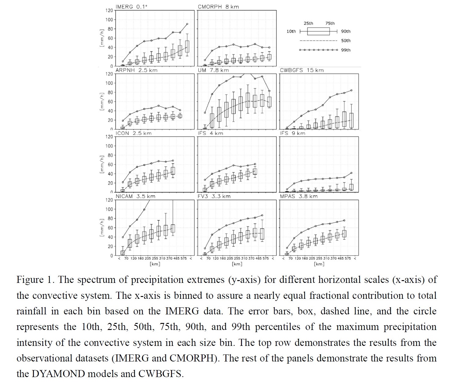
Plain Language Summary: We evaluate whether the DYAMOND models and the CWBGFS can reproduce the observed relationship between the precipitation features and the horizontal scale of convective systems. The result shows that the models with convection parameterization perform better in some of the metrics, and the models with a finer native resolution are not superior to the others.
Highlights:
- Global convection-permitting models with convection parameterization perform better in some of the system-based evaluation metrics, and the models with a finer native resolution are not superior to the others.
Article: Special Edition on Typhoons in 2018-2019
Otaki et al. (2022)
Otaki, T., H, Fudeyasu, N. Khono, T. Takemi, N. Mori, and K. Iida, 2022: Investigation of characteristics of maximum storm surges in Japanese coastal regions caused by Typhoon Jebi (2018) based on typhoon track ensemble simulations. J. Meteor. Soc. Japan, 100, 661-676.
Special Edition on Typhoons in 2018-2019
https://doi.org/10.2151/jmsj.2022-034
Graphical Abstract
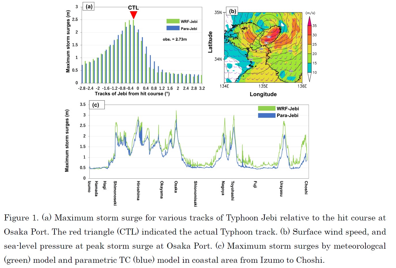
Plain Language Summary: This study estimated the maximum storm surges on the coast of Japan caused by Typhoon Jebi using the JMA storm surge model in conjunction with simulations based on the meteorological (WRF-Jebi) model and parametric TC (Para-Jebi) model. The storm surge at Osaka Port was estimated more accurately by the WRF-Jebi model than the Para-Jebi model. The typhoon track ensemble simulations demonstrated that the maximum storm surge was dependent on perturbation of the track of Typhoon Jebi along the entire coast of the Japanese Islands.
Highlights:
- In coastal areas where larger maximum storm surges were estimated, the longitudinally perturbed “worst-case course” appeared 0.4–0.8º west or east of the “hit course” (Fig. 1a), indicating that the wind setup effect was an important factor in the maximum storm surge.
- The differences between WRF-Jebi model and Para-Jebi model were due to a “wind setup effect,” where the topography enhanced surface winds over Osaka Bay (Fig. 1b).
- It is important to estimate the maximum storm surges and worst-case courses at all coastal area (Fig. 1c) because this will provide important information disaster prevention and risk management.
Article
Kusaka et al. (2022)
Kusaka, H., Y. Nakamura, and Y. Asano, 2022: UV parasol, dry-mist spraying, and street trees as tools for heat stress mitigation. . J. Meteor. Soc. Japan, 100, 677-685.
https://doi.org/10.2151/jmsj.2022-035
Graphical Abstract
Plain Language Summary:
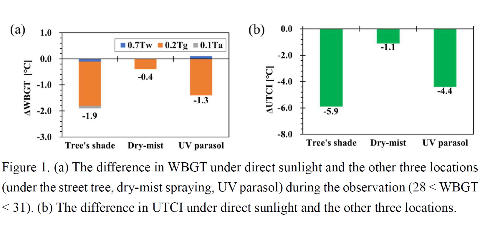
Ultraviolet (UV) parasols are a reasonable countermeasure against heat stress. We observed the UTCI and WBGT under UV parasol, street trees, dry-mist spraying, and direct sunlight. UV parasol reduced heatstroke risk by one level. The observed UTCI under the UV parasol was lower than that in direct sunlight by 4.4°C. The street trees reduced the UTCI by 5.9°C. In contrast, dry-mist spraying did not mitigate heat stress in conditions with moderate winds (≥ 2 m s−1).
Highlights:
- Street trees were the best of all the countermeasures and decreased the UTCI and WBGT by 5.9°C and 1.9°C, respectively, as compared with that in direct sunlight.
- The thermal mitigation effect of the UV parasol was equivalent to 75 % of that of street trees. The UV parasol was able to decrease the UTCI by 4.4°C and WBGT by 1.3°C.
- Street trees and UV parasol reduced heatstroke risk by one level.
- Dry-mist spraying did not mitigate heat stress in conditions with moderate winds (≥ 2 m s−1).
Article
Seo and Choi (2022)
Seo, J. and W. Choi, 2022: Stratospheric Polar Vortex Revisited: New Diagnostic for the Vortex Breakup. J. Meteor. Soc. Japan, 100, 687-705.
https://doi.org/10.2151/jmsj.2022-036
Graphical Abstract
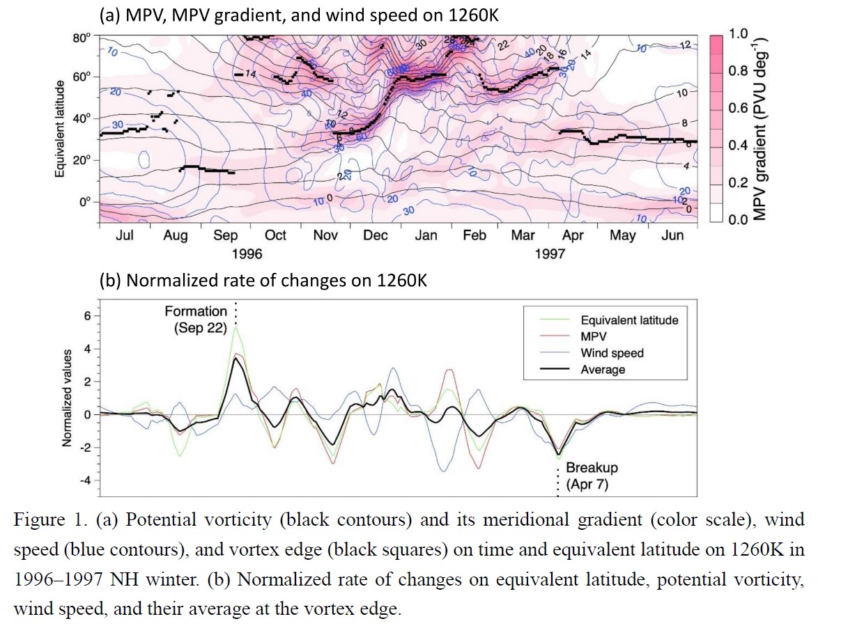
Plain Language Summary: Previous diagnostics for the breakup of stratospheric polar vortex have used prescribed key parameters based on potential vorticity and zonal wind in the lower stratosphere. This study defines a new diagnostic for the polar vortex formation and breakup by using the abrupt changes in the equivalent latitude, potential vorticity, and wind speed at the vortex edge. The new definition of the polar vortex formation and breakup can be applicable to the whole stratosphere.
Highlights:
- Polar vortex formation and breakup are newly defined by the maximum peak days in average rates of change in the equivalent latitude, potential vorticity, and wind speed at the vortex edge.
- The newly defined vortex formation and breakup dates match well the changes in concentrations of trace gases in the stratosphere.
- The new diagnostic for the vortex formation and breakup appears to be applicable to the whole stratosphere.
Article
Datt et al. (2022)
Datt, I., S. J. Camargo, A. H. Sobel, R. McTaggart-Cowan, Z. Wang, 2022: An Investigation of Tropical Cyclone Development Pathways as an Indicator of Extratropical Transition. J. Meteor. Soc. Japan, 100, 707-724.
https://doi.org/10.2151/jmsj.2022-037
Graphical Abstract
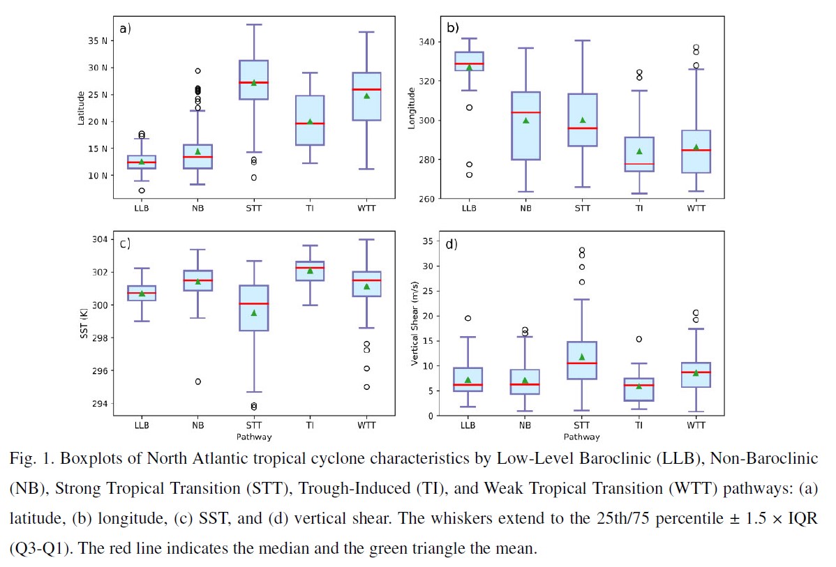
Plain Language Summary: This study investigates whether tropical cyclones that follow certain tropical cyclogenesis “pathways” in baroclinic environments are more likely to undergo extratropical transition than those that develop in non-baroclinic environments. The relationships between extratropical transition and two of the pathways investigated --- namely the strong tropical transition and trough-induced pathways --- are statistically significant in the North Atlantic and Western North Pacific, respectively. After controlling for genesis latitude and other environmental factors, the relationships remain statistically significant, implying that the specific mechanism of tropical cyclogenesis has a lasting effect on the probability of an eventual extratropical transition.
Highlights:
- In the North Atlantic basin, 79.5% of storms in the Strong Tropical Transition pathway undergo extratropical transition, while in the Western North Pacific basin, 55.3% of storms in the Trough Induced pathway undergo extratropical transition. Both are statistically significantly distinct from all other pathways at confidence levels above 95%.
- The results suggest that some tropical cyclones “remember” how they formed. However, the mechanism of such memory remains a question for future research.
JMSJ, 2022, Vol. 100, No. 5 (October)
Article
Li et al. (2022)
Li, H., X. GE, M. Peng, L. Li, 2022: The influences of Monsoon Trough on the relative motion of binary tropical cyclones. J. Meteor. Soc. Japan, 100, 729-749.
https://doi.org/10.2151/jmsj.2022-038
Graphical Abstract
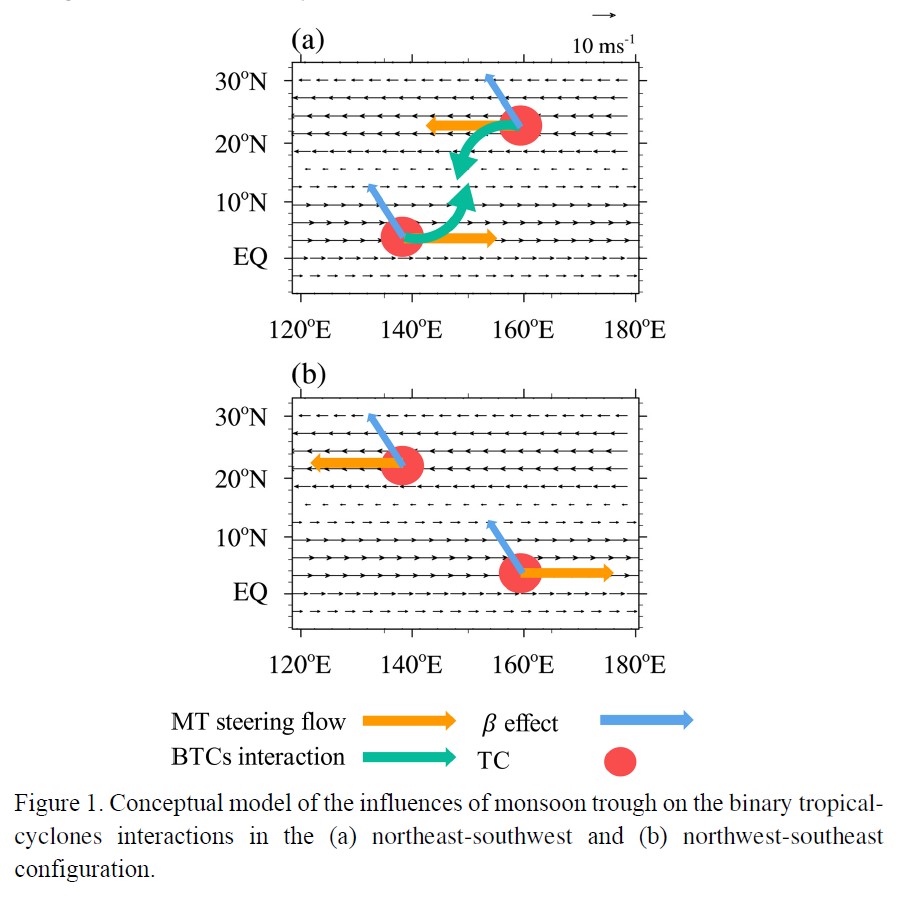
Plain Language Summary: In this study, the effect of the zonally-elongating monsoon trough (MT) on the binary tropical-cyclones (TCs) interaction is investigated by using data analysis and idealized simulations. The binary-TCs interaction is found to be sensitive to the relative orientation, intensities of the two TCs embedded in the MT, the strength of the MT, and the β-effect.
Highlights:
- The partition and reconstruction of wind field in a vortex core area of TC is applied to diagnosis the Fujiwhara interaction.
- The β-induced Rossby wave energy dispersion helps the western TC move northeastward, by which accelerates to reach the critical distance.
- The relative importance of monsoon trough and adjacent TC is assessed by using the decomposition of the steering flows.
Article
Yamada and Kusaka (2022)
Yamada, S., H. Kusaka, 2022: Spatial Structure and Formation Mechanism of Local Winds “Suzuka-oroshi” at the Foothills of Suzuka Mountains. J. Meteor. Soc. Japan, 100, 751-766.
https://doi.org/10.2151/jmsj.2022-039
Graphical Abstract
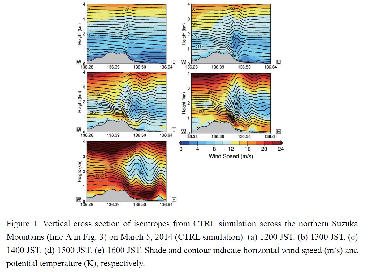
Plain Language Summary: We examined the essential features and formation mechanism of the strong local “Suzuka-oroshi” winds, which are located leeward of the Suzuka Mountains in Japan. Climatological analysis revealed when and where strong winds mainly occur. Numerical simulations supported this finding. Additionally, simulation results demonstrated that the strong Suzuka-oroshi comprised downslope windstorms with transition of flow regime.
Highlights:
- Climatological analysis revealed that Suzuka-oroshi mainly occurred after an extratropical cyclone with a cold front and passed the Sea of Japan (55 % of all occurrences) and inversion layers (1-5 km level) were observed in 74 % of cases.
- Climatological analysis using spatially dense observational data showed that the strongest winds tended to blow in the northern part of the plain on the leeward side.
- The strong Suzuka-oroshi in the northern part of the plain comprised downslope windstorms with transition of flow regime (internal Froude number was less than 1.0 at the windward of mountains and larger than 1.0 above the leeward slope).
Article
Ishiyama et al. (2022)
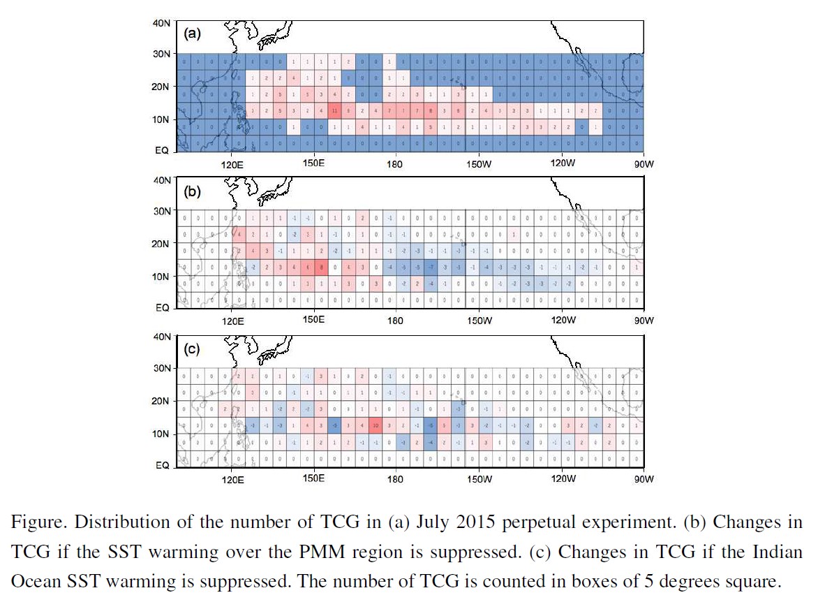
Ishiyama, T, M. Satoh and Y. Yamada, 2022: Possible roles of the sea surface temperature warming of the Pacific Meridional Mode and the Indian Ocean warming on tropical cyclone genesis over the North Pacific for the super El Niño in 2015. J. Meteor. Soc. Japan, 100, 767-782.
https://doi.org/10.2151/jmsj.2022-040
Graphical Abstract
Plain Language Summary: Focusing on the 2015 Super El Niño, this study reveals the possible role of sea surface temperature (SST) warming over the Pacific meridional mode (PMM) region and the Indian Ocean on tropical cyclogenesis (TCG) in the North Pacific. The global nonhydrostatic model results show that, under conditions of El Niño forcing, warming SSTs associated with the PMM decrease TCG in the western North Pacific and increase TCG in the eastern North Pacific. The Indian Ocean SST warming also decreases TCG in the western North Pacific.
Highlights:
- We use the global non-hydrostatic model (NICAM) to conduct perpetual experiments by integrating for 30 months to obtain a climatological condition of July 2015.
- Under the July 2015 SST condition, if the SST warming with PMM is suppressed, the monsoon trough in the western North Pacific (WNP) and vertical wind shear over the eastern North Pacific (ENP) become stronger, causing increased TCG in WNP and decreased TCG in ENP.
- Suppression of IO SST warming leads to a stronger monsoon trough and more TCG in WNP.
Article
Yanase et al. (2022)
Yanase, W., K. Araki, A. Wada, U. Shimada, M. Hayashi and T. Horinouchi, 2022: Multiple dynamics of precipitation concentrated on the north side of typhoon Hagibis (2019) during extratropical transition. J. Meteor. Soc. Japan, 100, 783-805.
https://doi.org/10.2151/jmsj.2022-041
Graphical Abstract
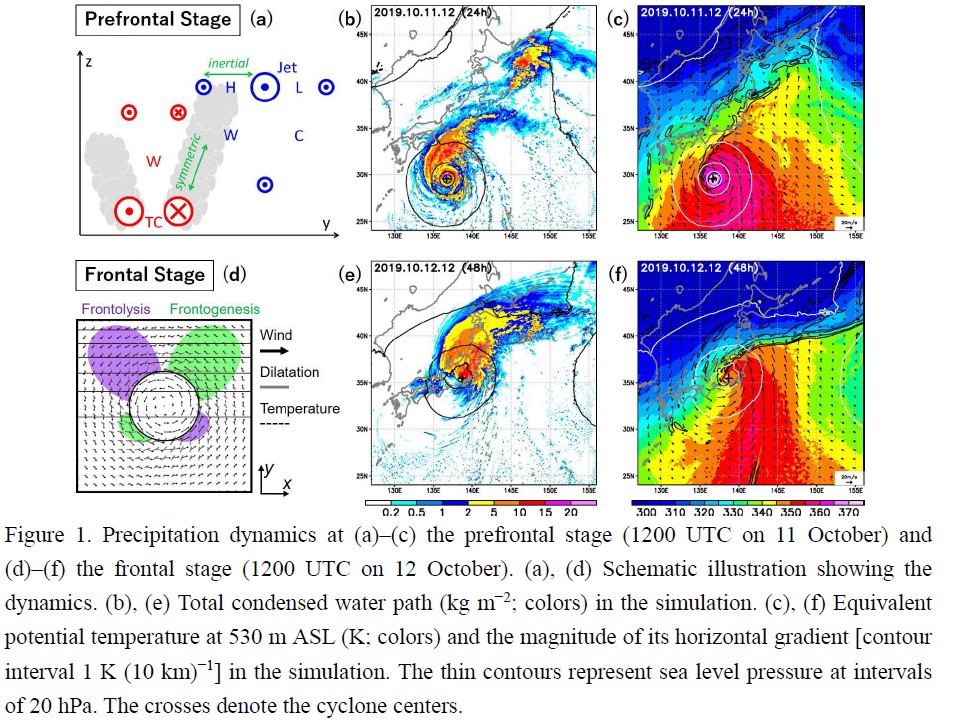
Plain Language Summary: Torrential rain in Typhoon Hagibis caused a devastating disaster in Japan in October 2019. The precipitation concentrated in the northern half of the typhoon was attributed to different dynamics depending on the stages of extratropical transition. It was enhanced by reduced moist symmetric stability between the typhoon and a westerly jet stream at the prefrontal stage, whereas it was concentrated in a warm front northeast of the typhoon at the frontal stage.
Highlights:
- The precipitation mechanism at the frontal stage (12 October) was consistent with that proposed by previous studies; the precipitation was attributed to warm frontogenesis northeast of the typhoon (Figs 1d–1f).
- In contrast, the precipitation at the prefrontal stage (11 October) occurred in a slantwise northward ascending motion enhanced by reduced moist symmetric stability between the typhoon and the westerly jet stream to the north (Figs. 1a–1c).
Article
Li and Li (2022)
Li, L., S. Li, 2022: A Comparison of two 20th century reanalysis datasets from the perspective of cross-equatorial flows. J. Meteor. Soc. Japan, 100, 807-824.
https://doi.org/10.2151/jmsj.2022-042
Graphical Abstract
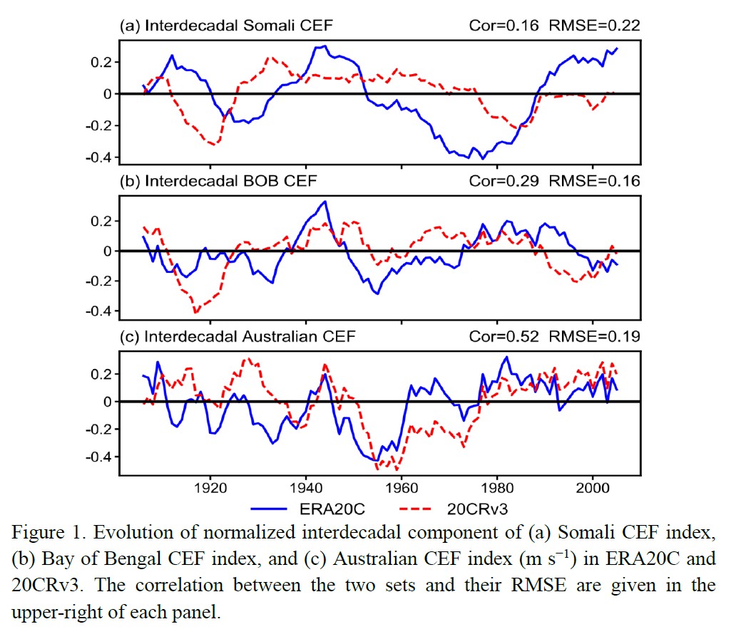
Plain Language Summary: This study compared two sets of 20th century reanalyses, ERA20C and 20CRv3, from the perspective of boreal summer low-level cross-equatorial flows (CEFs) over the Asian-Australian monsoon region. The results show a substantial gap between them in CEFs’ interdecadal variability, and ERA20C is more reliable than 20CRv3, in spite of their overall consistence in climatological mean, interannual variability and long-term trend.
Highlights:
- Cross-equatorial sea-level pressure gradient and Indian summer monsoonal rainfall are verified as two benchmarks for inspecting CEFs’ reliability.
- 20CRv3 and ERA20C have an overall consistence in CEFs’ climatological spatial structure, interannual variability and long-term trend, but a substantial gap in interdecadal variability.
- ERA20C is validated to be more suitable for investigating decadal variability associated with CEFs.
Article
Ishida et al. (2022)
Ishida, J., K. Aranami, K. Kawano, K. Matsubayashi, Y. Kitamura, C. Muroi, 2022: ASUCA: the JMA operational non-hydrostatic model. J. Meteor. Soc. Japan, 100, 825-846.
https://doi.org/10.2151/jmsj.2022-043
Graphical Abstract
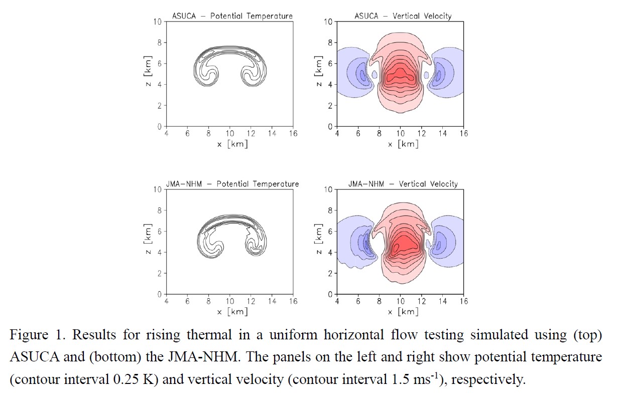
Plain Language Summary: Japan Meteorological Agency (JMA) developed the non-hydrostatic numerical weather prediction (NWP) model named ASUCA. This paper outlines specifications of ASUCA with focus on the dynamical core and its configuration/accuracy as an operational model. ASUCA exhibited better performance than the previous operational model in idealized and NWP tests.
Highlights:
- ASUCA employs the third-order advection scheme with the flux-limiter function to preserve monotonicity and time-splitting techniques for the acoustic terms to achieve high computational stability.
- The dynamical core of ASUCA satisfies total mass conservation due to employing the flux-form total density equation with finite volume method.
- ASUCA is optimized for massive parallel scalar computers and designed so that computation, communication and disk-I/O are overlapped as much as possible.
JMSJ, 2022, Vol. 100, No. 6 (December)
Article
Zeng et al. (2022)
Zeng, Y., L. Yang, Y. Zhou, Z. Tong, Y. Jiang, 2022: Statistical Characteristics of Summer Season Raindrop Size Distribution in the Western and Central Tianshan Mountains in China. J. Meteor. Soc. Japan, 100.
https://doi.org/10.2151/jmsj.2022-044
Graphical Abstract
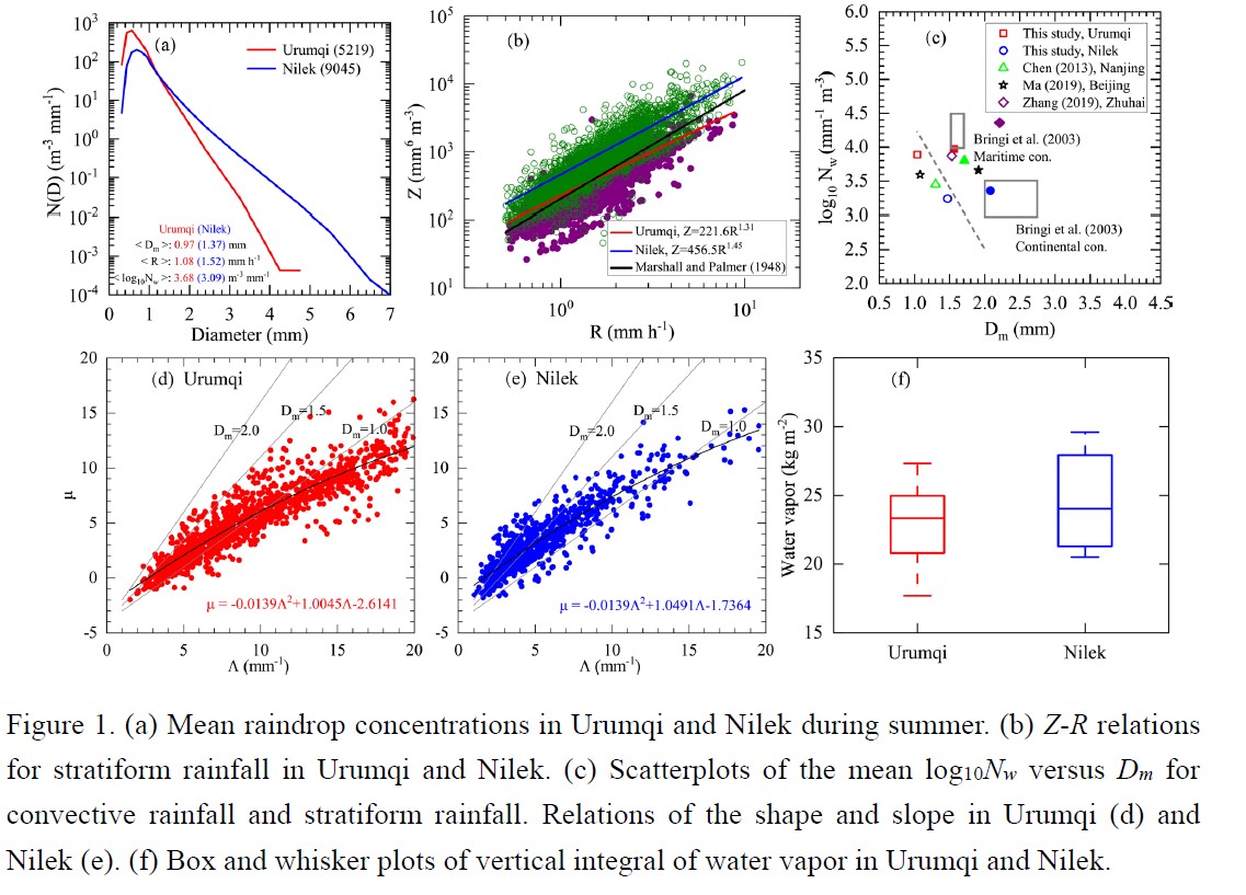
Plain Language Summary: This study focused on DSD variability in two different regions (Urumqi and Nilek) of the Tianshan Mountains in China. Parsivel2, ERA5, and FY-2G datasets were used to analyze and understand the DSD variability between Urumqi and Nilek. DSD variability was attributed to topographic difference between Urumqi and Nilek. By comparing DSDs of two different regions, we have got some interesting conclusions, such as DSDs in Nilek had larger Dm and smaller Nw as compared to that in Urumqi.
Highlights:
- Characteristics of raindrop size distribution (DSD) in summer in the western (Nilek) and central (Urumqi) regions in the Tianshan Mountains of China were studied based on three years of second-generation OTT Particle Size Velocity (Parsivel2) disdrometer data.
- The radar reflectivity, rain rate relations, and the shape and slope relations for rainfall in Urumqi and Nilek were obviously different. Convective clusters in Urumqi were similar to maritime clusters, whereas convective clusters in Nilek were more like continental clusters.
- The DSD variability in the two regions may be attributed to differences in convective intensity that are closely related to the specific terrain of the Tianshan Mountains.
Article
Sato et al. (2022)
Sato K., T. Kameda, T. Shirakawa, 2022: Heavy snowfall at Iwamizawa influenced by the Tsushima Warm Current. J. Meteor. Soc. Japan, 100.
https://doi.org/10.2151/jmsj.2022-045
Graphical Abstract
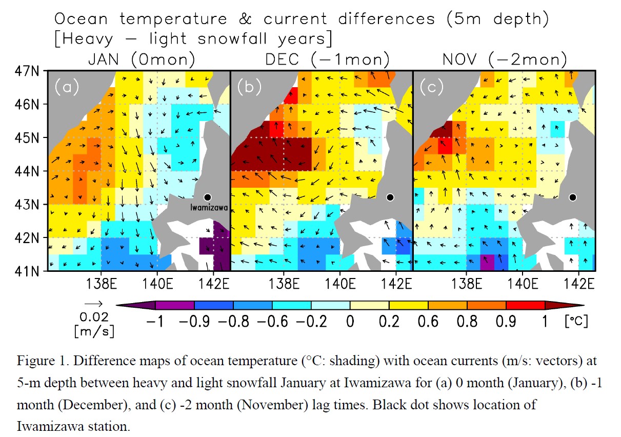
Plain Language Summary: This study used reanalysis data to investigate atmospheric and oceanic circulation anomalies associated with each anomalous heavy snowfall winter month at Iwamizawa on the Sea of Japan side of Hokkaido is one of the cities in Japan. During anomalous snowfall January, warm surface-layer ocean anomaly over the northern Sea of Japan, which preceded the heavy snowfall events at Iwamizawa by two months, has an important role in upward turbulent heat flux anomaly. This preceding warm ocean temperature anomaly was associated with a strong Tsushima Warm Current anomaly.
Highlights:
- Warm surface-layer ocean anomaly, which was seen over the northern Sea of Japan during anomalous snowfall January at Iwamizawa, causes increase in snowfall amounts in coastal regions of western Hokkaido.
- This warm surface-layer ocean anomaly preceded the heavy snowfall events at Iwamizawa by two months (i.e. December and November).
- This preceding warm ocean temperature anomaly was associated with a strong Tsushima Warm Current anomaly
Article
Kodama and Satoh (2022)
Kodama S. and M. Satoh, 2022: Statistical analysis of remote precipitation in Japan caused by typhoons in September. J. Meteor. Soc. Japan, 100.
https://doi.org/10.2151/jmsj.2022-046
Graphical Abstract
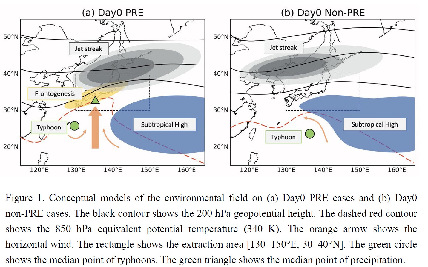
Plain Language Summary: During the autumn rainy season, typhoons located far from Japan sometimes cause significant precipitation in Japan. In this study, we characterized remote precipitation events (PRE cases) in September for 40 years from 1980 to 2019. We also analyzed cases in which remote precipitation did not occur despite approaching typhoons (non-PRE cases), as well as cases in which heavy precipitation was not affected by typhoons (non-typhoon cases). In particular, the comparison of the PRE cases and the non-PRE cases revealed differences regarding the extension of the subtropical high and the location of the jet streak.
Highlights:
- The subtropical high south of Japan was retreating for the PRE cases during the two days before PRE occurrence, while it was strengthening for the non-PRE cases.
- The jet streak entrance east of the 200 hPa trough was close to the precipitation area for the PRE cases. By contrast, for the non-PRE cases, the 200 hPa jet streak entrance was located to the west compared to the PRE cases.
- The northward water vapor inflow from the middle troposphere was larger in the PRE cases than in the non-typhoon cases.
Article
Kusunoki and Ueno (2022)
Kusunoki K. and K. Ueno, 2022: Development of a nocturnal temperature inversion in a small basin associated with leaf area ratio changes on the mountain slopes in central Japan. J. Meteor. Soc. Japan, 100.
https://doi.org/10.2151/jmsj.2022-047
Graphical Abstract
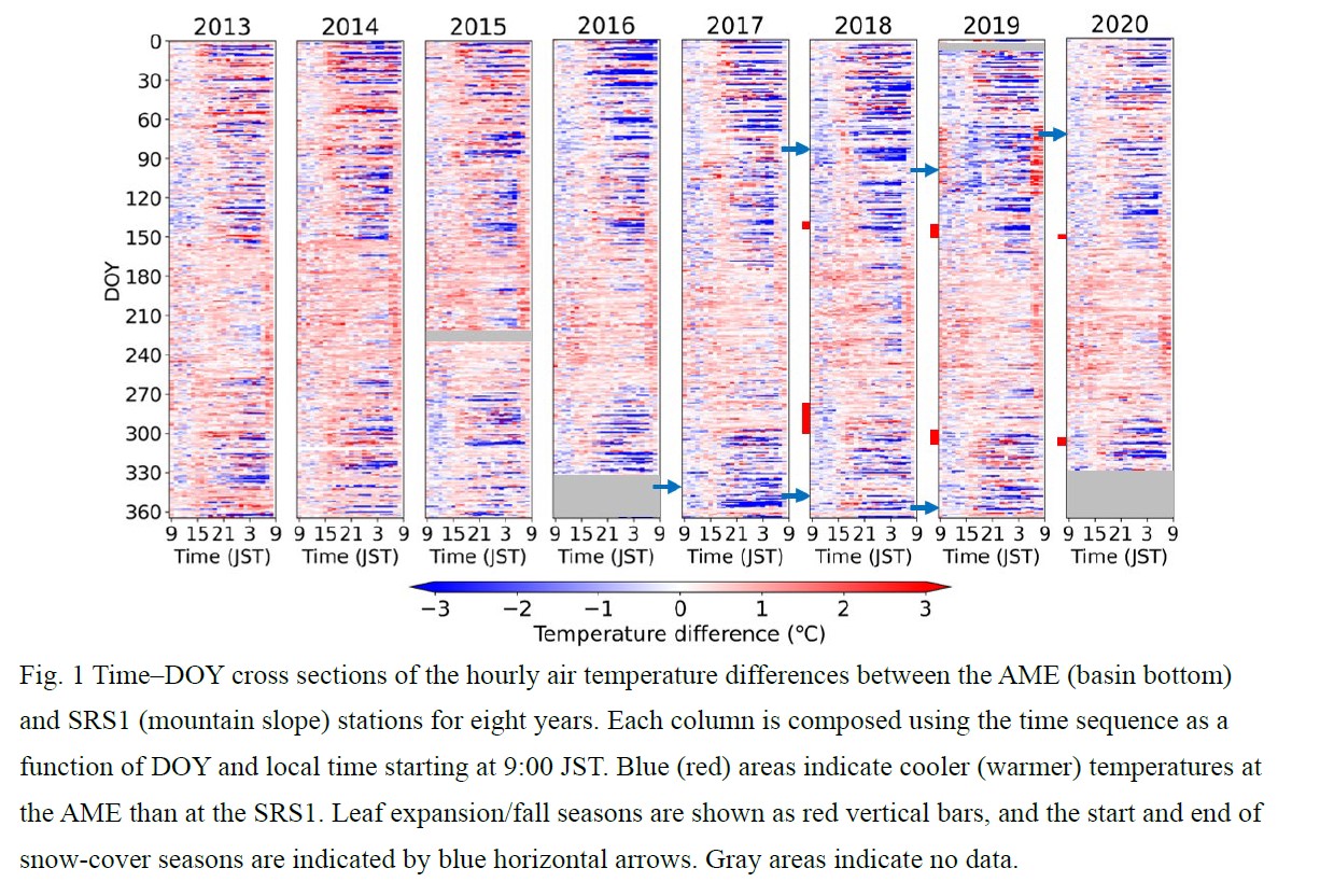
Plain Language Summary: According to a three-year leaf area index observation in the mixed forest of the Sugadaira Highland (1320 m a.s.l.), Nagano Prefecture, Japan, we identified weakening of the nocturnal temperature inversion (NTI) associated with leaf expansion and strengthening after leaf fall in a small basin. Heat-budget assessment for the cold-air pool development indicated that an increase in storage heat flux of forests with leaf expansion could cancel nocturnal radiative cooling and weaken gravity currents at the forest floor.
Highlights:
- We identified weakening of the NTI associated with leaf expansion and strengthening after leaf fall of mountain forests in a small basin of Nagano Prefecture, Japan.
- Micrometeorology observations showed that the NTI at the forest floor and downslope winds at the adjacent grassland strengthened during the dormant (leafless) season in the nighttime when the radiative cooling is strong.
- Heat-budget assessments showed that the heat loss during the cold-air pool development was 3.8 W/m2 more on average in the dormant season than the growing season, and it was less than that of storage heat flux by forests estimated in previous studies (several 10 W/m2).
Article
Lu et al. (2022)
Lu, X., W.-K. Wong, H. Yu, X. Yang, 2022: Tropical cyclone size identification over the Western North Pacific using support vector machine and general regression neural network. J. Meteor. Soc. Japan, 100.
https://doi.org/10.2151/jmsj.2022-048
Graphical Abstract
Plain Language Summary: Identification models of size for TCs in the WNP were proposed based on the infrared channel imagery of geostationary meteorological satellites. Several different machine learning algorithms were tested for different TC size parameters, including RMW, R34, R50, and R64. It is obtained that RMW and R34 can be best estimated by the support vector machine models, while R50 and R64 can be best estimated by the general regression neural network models. These models are used to set up a dataset of TC size for a nearly 40-yr period in the WNP region.
Highlights:
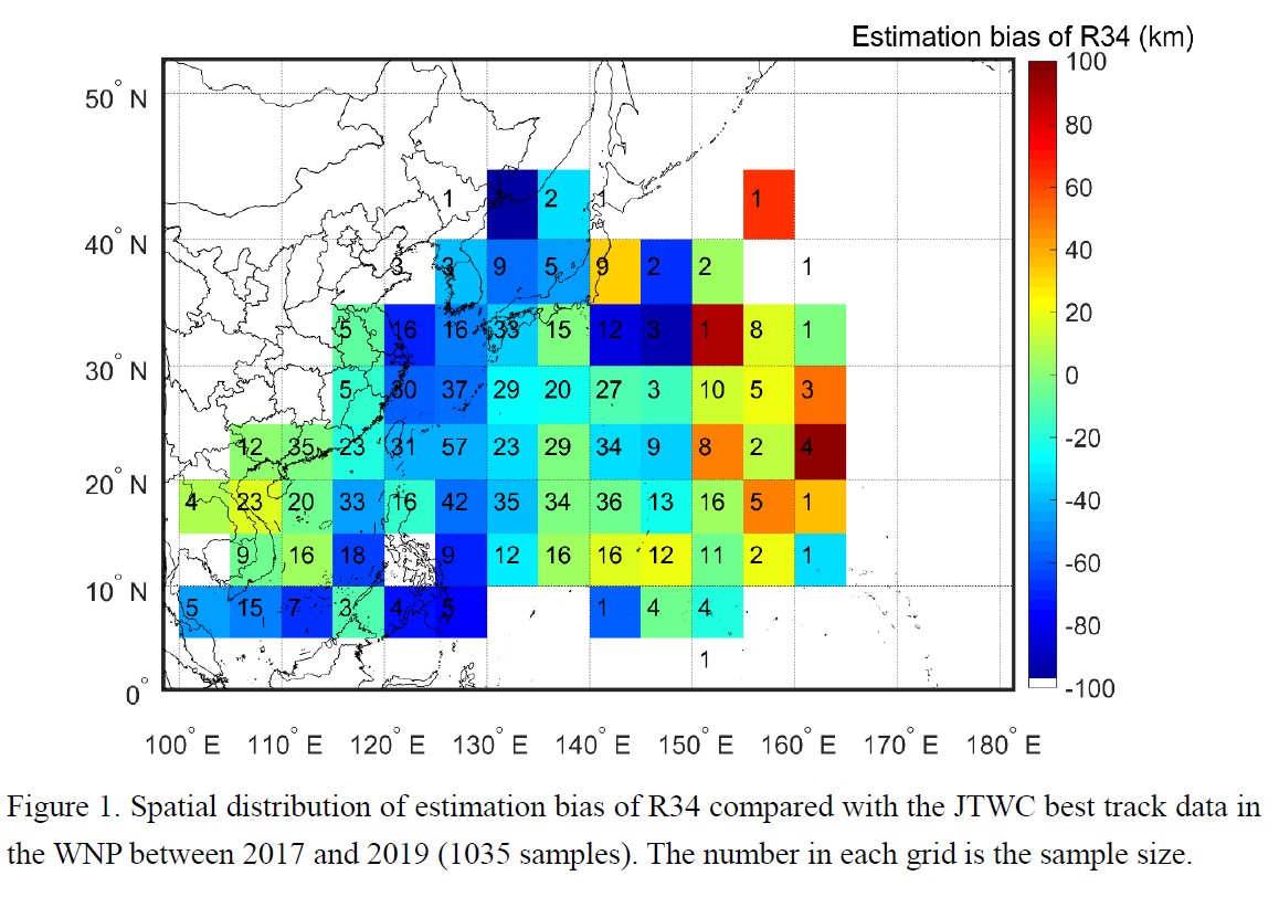
- The spatial distribution of estimation bias of R34 (Fig. 1) indicates its underestimation near land, such as the coastal areas of the Philippines, East China, and the Korean Peninsula. When a TC is close to land, friction may lead to an inclination of the TC in the vertical direction. Then the BTP across the weak convection away from the center is obtained due to the misalignment of the center of the high-level cloud top and the surface center, which results in an underestimation of R34 in the model. On the other hand, R34 is overestimated in the region where a TC has just formed. It is plausible that dense cloud clusters associated with developing TCs may provide the model with false BTP features suggesting stronger convection, leading to overestimation. Overall, the validation shows that the proposed models perform satisfactorily in providing accurate and reliable estimated wind radii, except for at certain latitude regions or for unusually large TCs.
Article: Special Edition on Typhoons in 2018-2019
Jin et al. (2022)
Jin, H., J. R. Moskaitis, Y.Jin and J. D. Doyle, 2022: Resolution impact on rapid intensification and structure change of super typhoon Hagibis (2019). J. Meteor. Soc. Japan, 100.
Special Edition on Typhoons in 2018-2019
https://doi.org/10.2151/jmsj.2022-049
Graphical Abstract
Plain Language Summary: The evolution of a heavy rainfall event occurred on 19 August 2014 in northern Taiwan is investigated with observed data and analyses from a newly-developed 4DVar data assimilation system named IBM_VDRAS. This event possesses different precipitating processes and track from those frequently observed in that region. The kinematic, thermodynamic, and microphysical fields of the convective cells are analyzed in details to explain the mechanisms which help to maintain the structure of the convective system and lead to heavy precipitation.
Highlights:
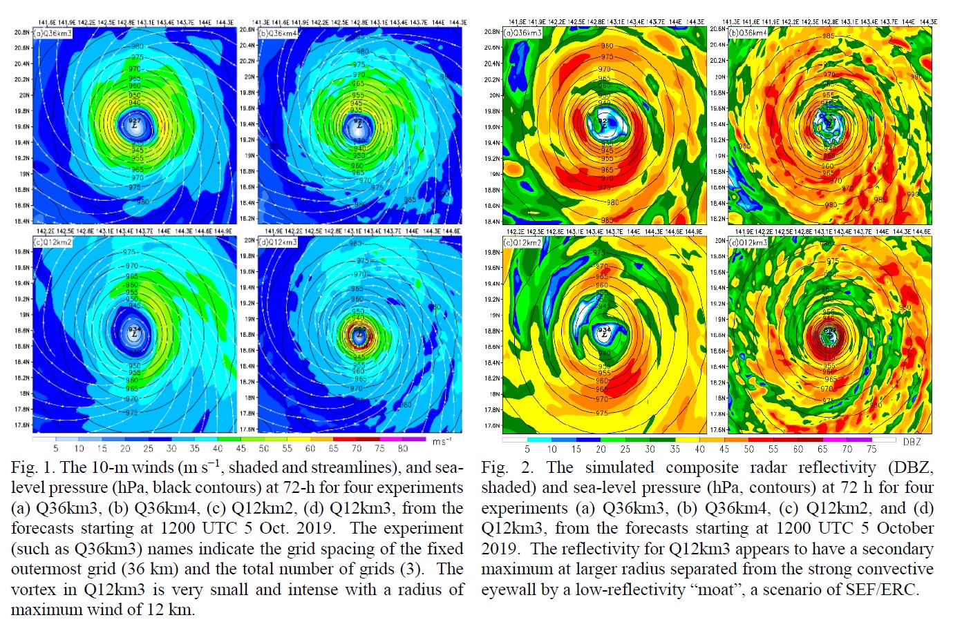
- Our sensitivity experiments indicate that realistic simulation of Hagibis’ SEF/ERC requires simulation of a very intense storm with a small inner core as a prerequisite; therefore the finest grid spacing at 1.33-km is a necessary but not sufficient condition to capture the SEF/ERC.
- The simulation of the RI and SEF/ERC is also sensitive to the resolution of the outermost grid, which has impacts on the storm’s moisture distribution by modulating the flow of moist air from the deep tropics into the TC.
- While these results have implications for the grid configuration of TC prediction models similar to COAMPS-TC, it is also important to gain systematic understanding of the physical processes associated with simulation of explosive RI and SEF/ERC, and the interactions between fine-scale aspects of the TC vortex evolution and that of the large-scale environment.
Article
Mukougawa et al. (2022)
Mukougawa, H., S. Noguchi, Y. Kuroda and R. Mizuta, 2022: On the Existence of the Predictability Barrier in the Wintertime Stratospheric Polar Vortex: Intercomparison of Two Stratospheric Sudden Warmings in 2009 and 2010 Winters. J. Meteor. Soc. Japan, 100.
https://doi.org/10.2151/jmsj.2022-050
Graphical Abstract
Plain Language Summary: This study examines the predictability of two stratospheric sudden warming (SSW) events occurring in 2009 and 2010 by conducting ensemble forecasts using an Atmospheric General Circulation Model (AGCM) combined with linear stability analysis of zonally-asymmetric ensemble mean fields using a nondivergent barotropic vorticity equation. The 2009 (2010) event has characteristics of vortex-splitting (vortex-displacement) SSW.
Highlights:
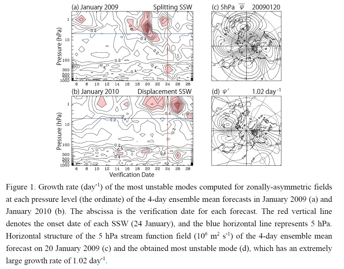
- The predictable period of the 2009 SSW is about 7 days which is much shorter than that of the 2010 SSW. The latter event is predictable more than 13 days.
- The distorted polar vortex in the upper stratosphere just before the onset of the 2009 SSW is highly unstable, whereas such unstable modes are absent in the stratosphere for the 2010 SSW.
- A predictability barrier inherent in the upper stratospheric circulation characterized by the unstable modes with large growth rates limits the predictable period of the 2009 SSW.
Article
Sakurai et al. (2022)
Sakurai, N., H. Fudeyasu, P. R. Krehbiel, R. J. Thomas, W. Rison, and D. Rodeheffer, 2022: Positive cloud-to-ground lightning characteristics in the eyewall of Typhoon Faxai (2019) observed by Tokyo lightning mapping array. J. Meteor. Soc. Japan, 100.
https://doi.org/10.2151/jmsj.2022-051
Graphical Abstract
Plain Language Summary: Typhoon Faxai (T1915) struck the Kanto region of Japan during September 8 and 9, 2019, producing many lightning discharges. This study investigated the characteristics of the lightning activity in comparison with the internal structure of precipitation in the eyewall. The storm was highly unusual in that it produced a high percentage of positive cloud-to-ground (CG) flashes, despite appearing to be normally electrified.
Highlights:
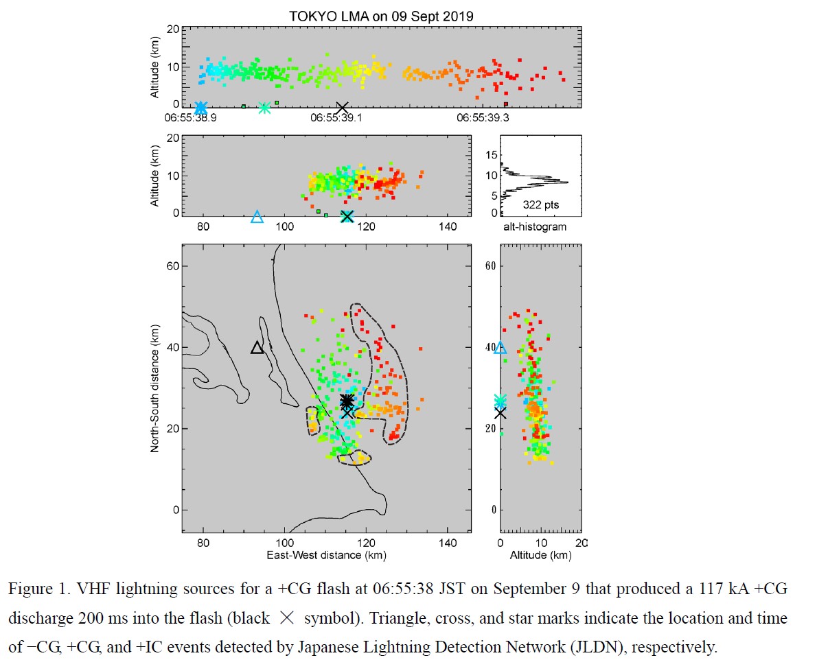
- The energetic positive strokes occurred partway through the flashes. Arrival of ground potential within the cloud initiated characteristic “blooming” of the breakdown in different directions away from the extremities of the preceding activity, including an entirely new branch to the east and north.
- That the normally-electrified storm produced positive instead of negative CG flashes indicates that the convective core of the storm had a depleted mid-level negative charge.
- The storm’s upper positive charge was advected downwind from above the convective core by strong upper level winds, giving rise to horizontally extensive flash extents.
Article
Hatsuzuka et al. (2022)
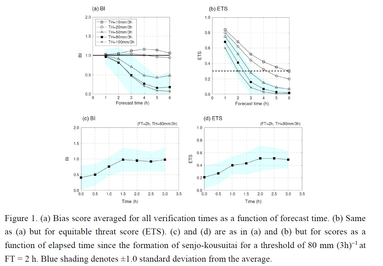
Hatsuzuka, D., R. Kato, S. Shimizu, K. Shimose, 2022: Verification of forecasted three-hour accumulated precipitation associated with “Senjo-Kousuitai” from Very-Short-Range forecasting operated by the JMA. J. Meteor. Soc. Japan, 100.
https://doi.org/10.2151/jmsj.2022-052
Graphical Abstract
Plain Language Summary: In recent years, “senjo-kousuitai”, characterized as band-shaped areas of heavy rainfall, have frequently caused river floods and landslides in Japan. A challenge for mitigating and preventing such disasters is to forecast accumulated rainfall for several hours with an adequate lead time. This study investigated the usefulness of the immediate very-short-range forecast of precipitation (VSRF), issued by the Japan Meteorological Agency, in terms of prevention of senjo-kousuitai disasters. The usefulness was assessed based on forecast accuracy of 3-h accumulated rainfall for a threshold value of 80 mm at each forecast time (FT; i.e., 1–6 h), using various verification indices.
Highlights:
- We analyzed 21 senjo-kousuitai events that occurred in Kyushu in 2019 and 2020.
- The VSRF produces useful forecasts of heavy rainfall associated with senjo-kousuitai for up to 2 h ahead (i.e., ETS ≥ 0.3 for a threshold of 80 mm (3h) –1).
- Further analysis found that the VSRF is less skillful in the formation stage of senjo-kousuitai even at short FTs, primarily because of poor performance of extrapolation forecast.


