Graphical Abstract
JMSJ, 2018, Vol. 96, No. 1 (February)
Articles
Nishimoto et al. (2018)
Nishimoto, S., and H. Kanehisa, 2018: Analytical solutions of vortex Rossby waves associated with vortex resiliency of tropical cyclones. J. Meteor. Soc. Japan, 96, 5-24.
https://doi.org/10.2151/jmsj.2018-003
Graphical Abstract
Highlights:
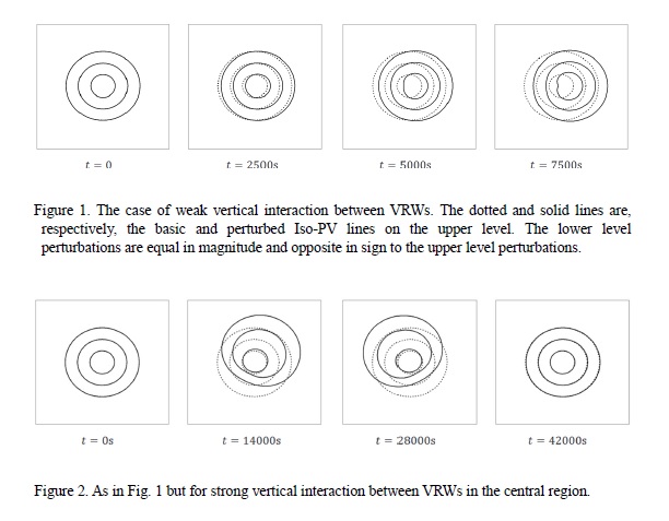
- As is well known, tropical cyclones (TCs) are resilient against destructive environmental vertical shear of moderate strength. In order to analytically investigate the resilience mechanism, we analytically examine the behaviour of vortex Rossby waves (VRWs) generated on TC-like vortices. Specifically, we consider a barotropic axisymmetric vortex in the quasigeostrophic system, whose potential vorticity (PV) is piecewise uniform in the radial direction. VRWs are excited on the basic vortex by an environmental flow which is unidirectionally (to the right in Figs. 1 and 2) vertically sheared. We obtain analytical solutions of the VRWs. The main results are shown in Fig. 1 and Fig. 2.
- Figure 1 shows the case of weak vertical interaction between VRWs. VRWs which are stationary in the azimuthal direction and linearly grow in time are selectively excited. The linear growth implies that the vortex is eventually destroyed by the environmental vertical shear.
- Figure 2 shows the case of strong and weak vertical interactions between VRWs in the central and outer regions, respectively. Because of the strong vertical interaction in the central region, the VRWs precess instead of linearly growing. The precession implies that the vortex maintains vertical coherence in spite of the environmental vertical shear.
Oizumi et al. (2018)
Oizumi, T., K. Saito, J. Ito, T. Kuroda, and L. Duc, 2018: Ultra-high-resolution numerical weather prediction with a large domain using the K Computer: A case study of the Izu Oshima heavy rainfall event on October 15-16, 2013. J. Meteor. Soc. Japan, 96, 25-54..
https://doi.org/10.2151/jmsj.2018-006
Graphical Abstract
Highlights:
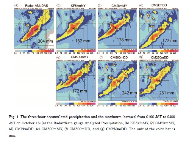
- In experiments with a large domain, the experiments with the Deardorff scheme (Exps_DD: grid spacings of 2 km, 500 m, and 250 m) showed better reproducibility of the rainband position than the ones with the Mellor–Yamada–Nakanishi–Niino scheme (Exps_MYNN: grid spacings of 5 km, 2 km, and 500 m).
- Exps_DD simulated distinct convective-scale up/downdraft pairs on the southeast/northwest sides of the front, whereas Exps_MYNN were not clear. Exps_DD yielded stronger cold pools near the surface than did Exps_MYNN. These differences in the boundary layer structures likely had a large impact on the position of the front and the associated rainband.
- An experiment with a small domain exhibited a very different appearance of the rainband to that with the large domain. However, with one-way nesting procedure, the experiment with the small domain could reproduce similar rainfall distribution to those with the large domain.
Notes and Correspondence
Roh et al. (2018)
Roh, W., and M. Satoh, 2018: Extension of a multisensor satellite radiance-based evaluation for cloud system resolving models. J. Meteor. Soc. Japan, 96, 55-63.
https://doi.org/10.2151/jmsj.2018-002
Graphical Abstract
Highlights:
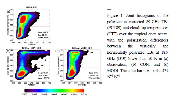
- A precipitation cloud evaluation method for cloud system resolving models are proposed using 11-μm brightness temperatures (TBs), high frequency microwave (89.0 GHz) TBs, and low frequencies (18.7 GHz) TBs over the ocean using satellite simulators (Fig. 1). This method can investigate precipitation clouds using two indexes, which represent the cloud-top height and large ice particle scattering intensity.
- The numerical results of the non-hydrostatic icosahedral atmospheric model (NICAM) with two cloud microphysics schemes were evaluated over the tropical open ocean using this method (Fig 1 b, c). The scattering intensities in both simulations at 89.0 GHz were different due to the parameterizations of the snow and graupel size distributions. A bimodal snow size distribution improved the TB underestimation at 89.0 GHz (Fig. 1 c).
- The impacts of nonspherical snow assumptions are investigated using a satellite simulator. The effect of a nonspherical snow shape in the radiative transfer model caused a small change in TBs at 89.0 GHz compared to the difference between the TBs of the two simulations without nonspherical assumptions.
JMSJ, 2018, Vol. 96, No. 2 (April)
Articles
Kato (2018)
Kato, T., 2018: Representative height of the low-level water vapor field for examining the initiation of moist convection leading to heavy rainfall in East Asia. J. Meteor. Soc. Japan, 96, 69-83.
https://doi.org/10.2151/jmsj.2018-008
Graphical Abstract
Highlights:
- Cloud base heights of moist convection with strong updrafts were simulated mainly around 500 and 300 m heights above sea level over land and over the ocean during April–August 2008, respectively. This result indicates that low-level humid air below a height of 500 m is very important for the initiation of strong moist convection.
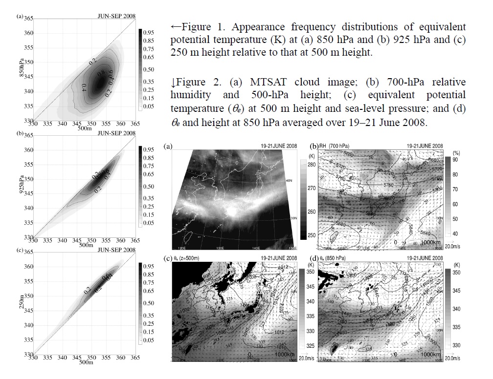
- Equivalent potential temperature θe at 500 m height from 10-km-resolution objective analysis data was statistically compared with θe at various heights and pressure levels over the ocean south of 35 °N in East Asia during June–September 2008. These comparisons (Fig. 1) showed that analyses at the 850-hPa level could not represent the low-level water vapor field. The θe field at 925 hPa also could not adequately represent the low-level water vapor field, but the difference in θe between heights of 250 and 500 m was very small.
- In the Baiu season since the 850-hPa θe distribution, but not the θe distribution at 500 m height, is close to the distribution of a humid region found at 700 hPa, produced by convective activity, it was strongly influenced by convective activity over the Baiu frontal zone (Fig. 2).
Yang et al. (2018)
Yang, C.-C., C.-C. Wu, and K. K. W. Cheung, 2018: Diagnosis of large prediction errors on recurvature of Typhoon Fengshen (2008) in the NCEP-GFS Model. J. Meteor. Soc. Japan, 96, 85-96.
https://doi.org/10.2151/jmsj.2018-009
Graphical Abstract
Highlights:
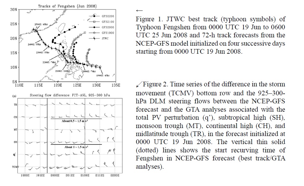
- The steering flow analysis based on potential vorticity (PV) diagnosis is used to examine the reasons why the National Centers for Environmental Prediction Global Forecast System (NCEPGFS) model showed large track forecast errors (Fig. 1) with over-recurving movement in Typhoon Fengshen (2008). In particular, two forecasts initialized at 0000 UTC 19 and 20 June 2008 are demonstrated in this study.
- The deep-layer-mean (DLM) steering flow between 925 and 300 hPa with tropical cyclone components filtered out is directed to the west or northwest in the analysis field, which can account for the continuous westward and northwestward movement in the best track. However, the DLM steering flow is shown more toward the north in the forecast fields.
- Four distinct PV features associated with the corresponding subtropical high, monsoon trough, continental high, and midlatitude trough are identified to diagnose their balanced steering flows around the storm.
- The result based on PV analysis indicates that the reduced westward steering flow in the forecast field (Fig. 2) is mainly attributed to the subtropical high which is over-predicted to extend southwestward, as well as the continental high with underestimated coverage, as characterized by the geopotential height at 500 hPa.
- The steering flow associated with the monsoon trough plays an essential role while Typhoon Fengshen (2008) experiences northward recurvature in both analysis and forecast fields. Therefore the associated reduced westward steering flow in the NCEP-GFS model leads to the over-recurvature of Fengshen.
Chen et al. (2018)
Chen, G., and K. Wang, 2018: Why is the tropical cyclone activity over the western North Pacific so distinct in 2016 and 1998 following super El Niño events? J. Meteor. Soc. Japan, 96, 97-110.
https://doi.org/10.2151/jmsj.2018-013
Graphical Abstract
Highlights:
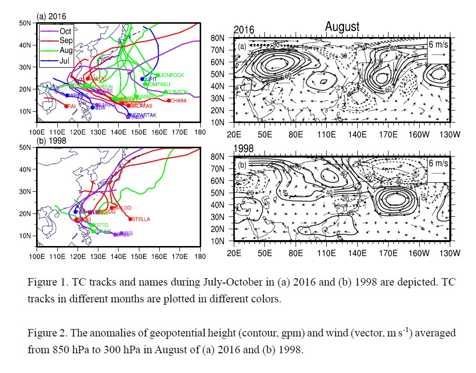
- Although both the tropical cyclone (TC) peak seasons in 2016 and 1998 are in the decaying stage of a super El Niño, TC activities over the western North Pacific (WNP) exhibit vast differences. The TCs in 2016 feature more number, greater intensity and more distinct monthly variation of TC activity in contrast to those in 1998 (Fig. 1).
- The warm sea surface temperature anomaly over the WNP in 2016 had a higher magnitude and a more eastward extension than in 1998. Especially in August coincident with the enhanced Madden-Julian oscillation westerly phase, more TCs clustered within the eastward-extending convective belt. The mean longitude of TC genesis in 2016 shifted more eastward, favorable for the longer lifetime and greater intensity of the TCs.
- In August of 2016, the WNP subtropical high was suddenly separated into the two anticyclonic components between which the cyclonic circulation was pronounced. This sandwich-like structure can be attributed to the apparent Silk Road Pattern-like wave train. In contrast, an enhanced positive geopotential height anomaly occupied over the central Northern Pacific in 1998 (Fig. 2).
Xu et al. (2018)
Xu, J., and Y. Wang, 2018: Effect of the initial vortex structure on intensification of a numerically simulated tropical cyclone. J. Meteor. Soc. Japan, 96, 111-126.
https://doi.org/10.2151/jmsj.2018-014
Graphical Abstract
Highlights:
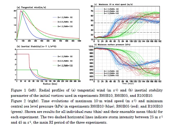
- the initial spinup period is shorter and the subsequent IR is larger for the storm with the initially smaller RMW or with the initially more rapid radial decay of tangential wind outside the RMW;
- the longevity of the initial spinup period is determined by how quickly the inner-core region becomes nearly saturated in the middle and lower troposphere and thus deep convection near the RMW is initiated and organized. Because of the larger volume and weaker Ekman pumping, the inner-core of the initially larger vortex takes longer time to become saturated and thus experiences a longer initial spinup period;
- the vortex initially with the larger RMW (with the slower radial decay of tangential wind outside the RMW) has lower inertial stability inside the RMW (higher inertial stability outside the RMW) develops more active convection in the outer-core region and weaker boundary-layer inflow in the inner-core region and thus experiences lower IR during the primary intensification stage.
The effect of the initial vortex structure, including the radius of maximum wind (RMW) and the radial decay rate of tangential wind outside the RMW, on the intensification rate (IR) of a tropical cyclone (TC) is studied based on ensemble of simulations using a nonhydrostatic axisymmetric cloud-resolving model. The results show that:
Long et al. (2018)
Long, J., Y. Wang, and S. Zhang, 2018: Intercomparison of cloud amount datasets in the Kuroshio region over the East China Sea. J. Meteor. Soc. Japan, 96, 127-145.
https://doi.org/10.2151/jmsj.2018-018
Graphical Abstract
Highlights:
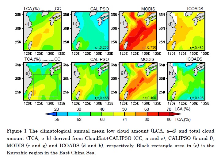
- LCA and TCA derived from MODIS and CALIPSO present considerable consistency with CC data in climatological annual mean and show similar behavior in seasonal cycle. The consistency in LCA between the three datasets and the CC is generally good in cold seasons (winter, spring and autumn) but poor in summer.
- MODIS shows the best agreement with CC in autumn with correlation coefficient of 0.77 at the confidence level over 99%.
- CALIPSO and MODIS can provide competitive description of TCA in all seasons while ICOADS is good in terms of climatological seasonal mean TCA in winter only.
- The interannual variation of LCA and TCA from all datasets is highly correlated with that from CC in winter and spring with the Matching Score (MS) ranging between 2/3 and 1. Further analysis with long-term data suggests that both LCA and TCA from ICOADS and MODIS can be good references for studies of cloud interannual variability.
The monthly low cloud amount (LCA) and total cloud amount (TCA) datasets in the Kuroshio region over the East China Sea in CALIPSO, MODIS and ICOADS are validated against the combined product of CloudSat+CALIPSO (CC) in terms of the consistency and discrepancy on climatologically mean, seasonal cycle, and interannual variation. The major findings are summarized below:
Fujibe (2018)
Fujibe, F., 2018: Climatological features of sub-hourly temperature variations in Japan. J. Meteor. Soc. Japan, 96, 147-160.
https://doi.org/10.2151/jmsj.2018-021
Graphical Abstract
Highlights:
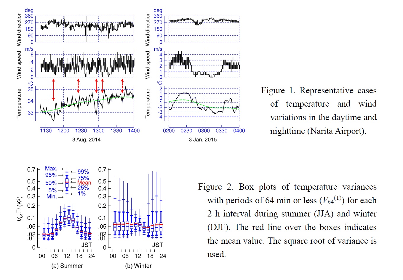
- Statistical analyses of temperature variations with periods of 64 min or less were made using 1 min data at 917 stations for four years, as the first step toward acquiring basic knowledge about the climatological features of sub-hourly temperature variations in Japan.
- Daytime temperature variation is observed throughout the country with larger amplitudes during spring and summer than during autumn and winter, and under high temperature and sunny weather than under low temperature, no sunshine, and precipitation. The variation is likely to correspond to the convective motion in the mixing layer.
- Nighttime temperature variation shows large scatter among stations, with exceptionally large variations during winter at some stations in northern and eastern Japan. Nighttime temperature variation tends to be in phase with wind speed variation, with longer periods than daytime temperature variation, and is more intense under low temperature and low wind speed than under high temperature, high wind speed, and precipitation. Stations with large winter nighttime temperature variations tend to be located on a col or a slope, where the surface inversion layer is likely to be easily disturbed by any kind of atmospheric motion.
Kawase et al. (2018)
Kawase, H., T. Sasai, T. Yamazaki, R. Ito, K. Dairaku, S. Sugimoto, H. Sasaki, A. Murata, and M. Nosaka, 2018: Characteristics of synoptic conditions for heavy snowfall in western to
northeastern Japan analyzed by the 5-km regional climate ensemble experiments. J. Meteor. Soc. Japan, 96, 161-178.
https://doi.org/10.2151/jmsj.2018-022
Graphical Abstract
Highlights:
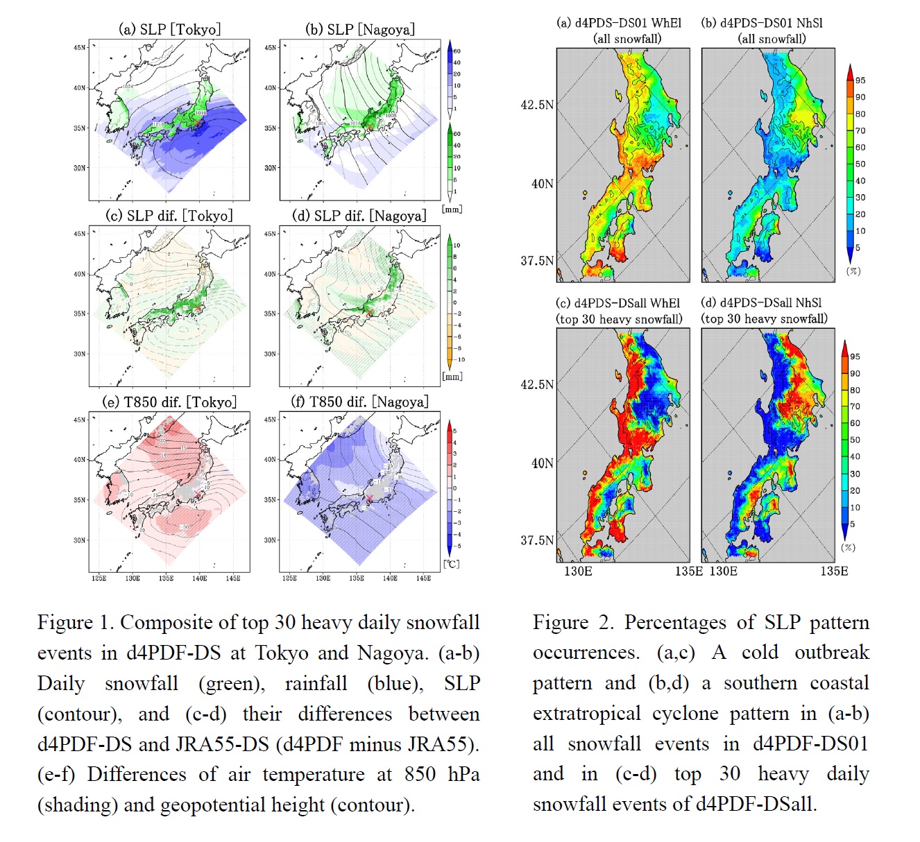
- We investigate the characteristics of synoptic conditions for heavy daily snowfall from western to northeastern Japan in the present climate, analyzing high-resolution regional climate ensemble experiments with 5-km grid spacing based on d4PDF (310 years) and JRA-55 (31 years).
- A comparison between JRA55-DS and d4PDF-DS indicates that heavier snowfall can occur due to more developed extratropical cyclones and enhanced cold air damming in Tokyo, while stronger cold air outbreaks and enhanced JPCZ can produce much heavier snowfall in Nagoya.
- Top 30 heavy snowfall events show much clearer geographical boundaries of two typical pattern, i,e., cold air outbreaks and southern coastal extratropical cyclones, than all snowfall events do.
Okamoto et al. (2018)
Okamoto, K., T. Ishibashi, S. Ishii, P. Baron, K. Gamo, T. Y. Tanaka, K. Yamashita, and T. Kubota, 2018: Feasibility study for future space-borne coherent Doppler wind lidar, Part 3: Impact assessment using sensitivity observing system simulation experiments. J. Meteor. Soc. Japan, 96, 179-199.
https://doi.org/10.2151/jmsj.2018-024
Graphical Abstract
Highlights:
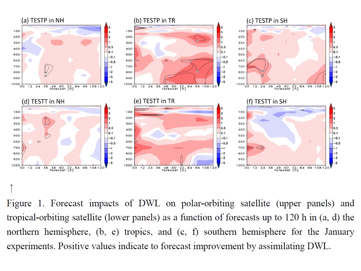
- The impact of a future space-borne Doppler wind lidar (DWL) on numerical weather prediction (NWP) was evaluated by using an observing system simulation experiment (OSSE) based on a sensitivity observing system experiment (SOSE) approach.
- DWL on either polar- or tropical-orbiting satellites was overall beneficial for forecasts (Fig 1), with greater impacts for the January experiments than for the August experiments.
- Realistic aerosols and cloud simulations and a full-scale lidar simulator were produced to simulate DWL winds and their quality information. This information allowed us to develop sophisticated quality control and observation errors assignment in data assimilation system. The significance of these procedures was demonstrated in various data assimilation experiments.
Kuji et al. (2018)
Kuji, M., A. Murasaki, M. Hori, and M. Shiobara, 2018: Cloud fractions estimated from shipboard whole-sky camera and ceilometer observations between East Asia and Antarctica. J. Meteor. Soc. Japan, 96, 201-214.
https://doi.org/10.2151/jmsj.2018-025
Graphical Abstract
Highlights:
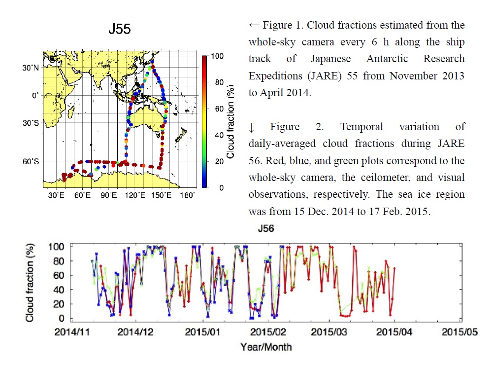
- Cloud fractions were observed during research cruises onboard the research vessel (R/V) Shirase between Japan and Antarctica using a whole-sky camera and a ceilometer. The cruises, Japanese Antarctic Research Expeditions (JARE) 55 and 56, took place from November 2013 to April 2014 and November 2014 to April 2015, respectively (Figs. 1 and 2).
- According to the comparison of daily-averaged cloud fractions from the whole-sky camera with the ceilometer observations over the open ocean between Japan and Antarctica, the correlation coefficients were 0.87 and 0.93 for JARE 55 and 56, respectively. Overall, the results from both observation methods were consistent over the open ocean.
- Furthermore, the daily-averaged cloud fractions estimated from the whole-sky camera were also consistent with the ceilometer observations over the sea ice regions where the correlation coefficients were 0.93 and 0.96 for JARE 55 and 56, respectively.
Uchiyama et al. (2018)
Uchiyama, A., B. Chen, A. Yamazaki, G. Shi, R. Kudo, C. Nishita-Hara, M. Hayashi, A. Habib, and T. Matsunaga, 2018: Aerosol optical characteristics in Fukuoka and Beijing measured by integrating nephelometer and aethalometer: Comparison of source and downstream regions. J. Meteor. Soc. Japan, 96, 215-240.
https://doi.org/10.2151/jmsj.2018-026
Graphical Abstract
Highlights:
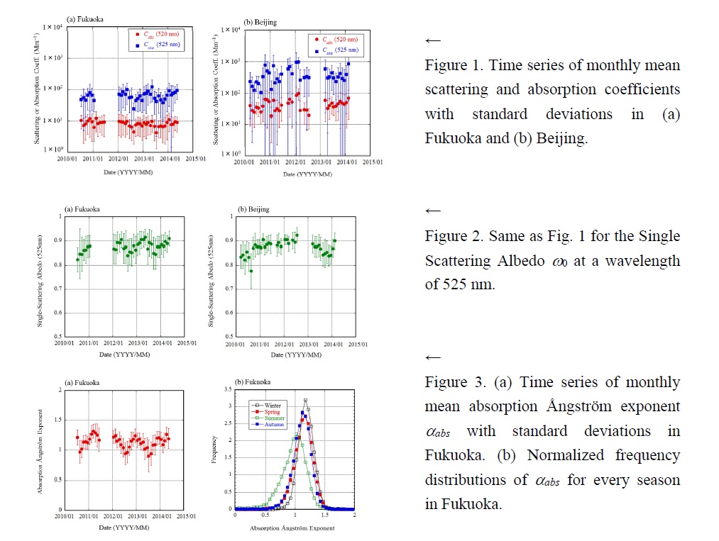
- The aerosol optical characteristics in the East Asian cities of Fukuoka and Beijing were measured from 2010 to 2014. Previously, few long-term, season-crossing observations have been reported.
- In Fukuoka, the annual means of the extinction, scattering, and absorption coefficients Cext (525 nm), Csca (525 nm), and Cabs (520 nm) were 74.6, 66.1, and 8.1 Mm−1, respectively, whereas those in Beijing were 412.1, 367.2, and 42.4 Mm−1, respectively (Fig. 1). The single-scattering albedos ω0 (525 nm) in the two cities were 0.877 and 0.868, respectively (Fig. 2). The asymmetry factors G (525 nm) in the two cities were 0.599 and 0.656, respectively. The extinction Ångström exponents αext in the two cities were 1.555 and 0.855, respectively. The absorption Ångström exponents αabs in the two cities were 1.106 and 0.977, respectively.
- Cext, Csca, and Cabs showed a seasonal variation in both cities. Some aerosol properties also showed a seasonal variation. In particular, the seasonal variation in αabs was clear in both cities; it tended to be small in summer and large in winter (Fig. 3).
JMSJ, 2018, Vol. 96, No. 3 (June)
Articles
Kawai et al. (2018)
Kawai, K., K. Kai, Y. Jin, N. Sugimoto, and D. Batdorj, 2018: Lidar network observation of dust layer development over the Gobi Desert in association with a cold frontal system on 22–23 May 2013. J. Meteor. Soc. Japan, 96, 255-268.
https://doi.org/10.2151/jmsj.2018-023
Graphical Abstract
Highlights:
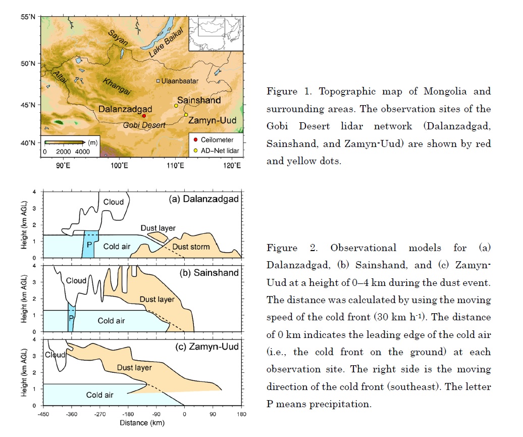
- The Gobi Desert is one of the major sources of Asian dust. In this desert, three ground-based lidars are operated in Dalanzadgad, Sainshand, and Zamyn-Uud, Mongolia (Fig. 1). This study firstly combined these lidars into a lidar network and shows the spatial development of a dust layer over the desert and the long-range transport of the dust during 22–23 May 2013.
- While the dust layer was moving across the desert with the cold frontal system, it was developing up to the free troposphere (Fig. 2). The mechanism of this development can be explained by the combination of two processes as follows: (1) the continuous emission of dust from the desert surface to the ABL by the strong wind around the cold front and (2) the continuous transport of the dust from the ABL to the free troposphere by the updraft of the warm air in the cold frontal system.
Wang et al. (2018)
Wang, Y., and X. Xu, 2018: Impact of ENSO on the thermal condition over the
Tibetan Plateau. J. Meteor. Soc. Japan, 96, 269-281.
https://doi.org/10.2151/jmsj.2018-032
Graphical Abstract
Highlights:
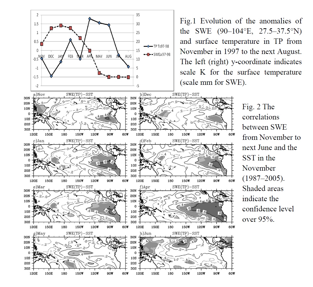
- There were significantly positive correlations between the snow water equivalent (SWE) over the Tibetan Plateau (TP) from November to next April and sea surface temperature (SST) in the Eastern Equatorial Pacific (Fig. 2).
- SST in Eastern Equatorial Pacific in November is most significantly correlated with the TP-SWE in next April, which suggests an accumulative effect of the ENSO on the TP snow cover.
- Preceding El Niño conditions tended to be associated with increasing TP surface temperature in May and there were significant positive correlations between SWE in April and TP surface temperature in May and June (e.g. Fig. 1).
- A plausible mechanism based on the relation of ENSO-TP thermal condition has been proposed. The mechanism explained the direct and indirect effects of ENSO on the TP thermal condition and role that the seasonal progress can play in this relation.
Notes and Correspondence
Takahashi et al. (2018)
Takahashi, H. G., and J. M. B. Dado, 2018: Relationship between sea surface temperature and rainfall in the Philippines during the Asian summer monsoon. J. Meteor. Soc. Japan, 96, 283-290.
https://doi.org/10.2151/jmsj.2018-031
Graphical Abstract
Highlights:
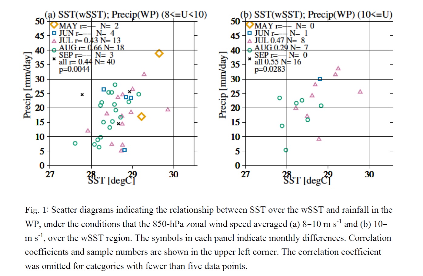
- We offer a new perspective on a relationship between sea surface temperature (SST) over the windward region of the Philippines and rainfall in the western Philippines during the Asian summer monsoon season, which has been known as the negative correlation.
- A warmer local SST results in greater rainfall over the western Philippines under similar monsoon westerlies conditions, particularly during moderate and relatively stronger monsoon regimes (Fig. 1). This result is obtained after selecting only the moderate or relatively stronger monsoon days, because the positive effect of SST on rainfall is masked by the apparent negative correlation between SST and rainfall.
- The warmer SSTs being associated with less rainfall correspond to weaker cooling by weaker monsoon westerlies and the cooler SSTs being associated with more rainfall correspond to stronger cooling by stronger monsoon westerlies. The cooler SSTs are the result of stronger monsoon cooling and are not the cause of the greater rainfall, which is the apparent statistical relationship.
JMSJ, 2018, Vol. 96, No. 4 (August)
Review Articles
Chan et al. (2018)
Chan, K. T. F., and J. C. L. Chan, 2018: The outer-core wind structure of tropical cyclones. J. Meteor. Soc. Japan, 96, 297-315.
https://doi.org/10.2151/jmsj.2018-042
Graphical Abstract
Highlights:
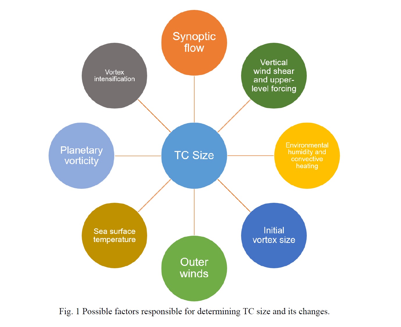
- This review summarizes the main findings of the observational and numerical studies on the climatology and possible change mechanisms on the outer-core wind structure of a tropical cyclone (TC), which has been generally referred to as size, a term also to be used in this review, from the earlier works before the satellite era to the latest ones.
- Based on the various studies, it is apparent that within a specific ocean basin, TC size has both temporal (seasonal, interannual and perhaps even interdecadal) as well as spatial (latitude and longitude) variations, which are related to the different synoptic-scale flow patterns in which the TCs are embedded and the different magnitudes of the Coriolis force.
- Both observational analyses and numerical simulations show that various factors are likely responsible for determining TC size and its changes. These include import of angular momentum in the lower troposphere, upper-level forcing, environmental humidity, initial vortex structure (size and outer winds), sea surface temperature, planetary vorticity, and vortex intensification.
Articles
Cao et al. (2018)
Cao, X., and R. Wu, 2018: Comparison of different time scale contributions to tropical cyclone genesis over the western North Pacific in 2015 and 2016. J. Meteor. Soc. Japan, 96, 317-336.
Special Edition on Tropical Cyclones in 2015–2016
https://doi.org/10.2151/jmsj.2018-038
Graphical Abstract
Highlights:
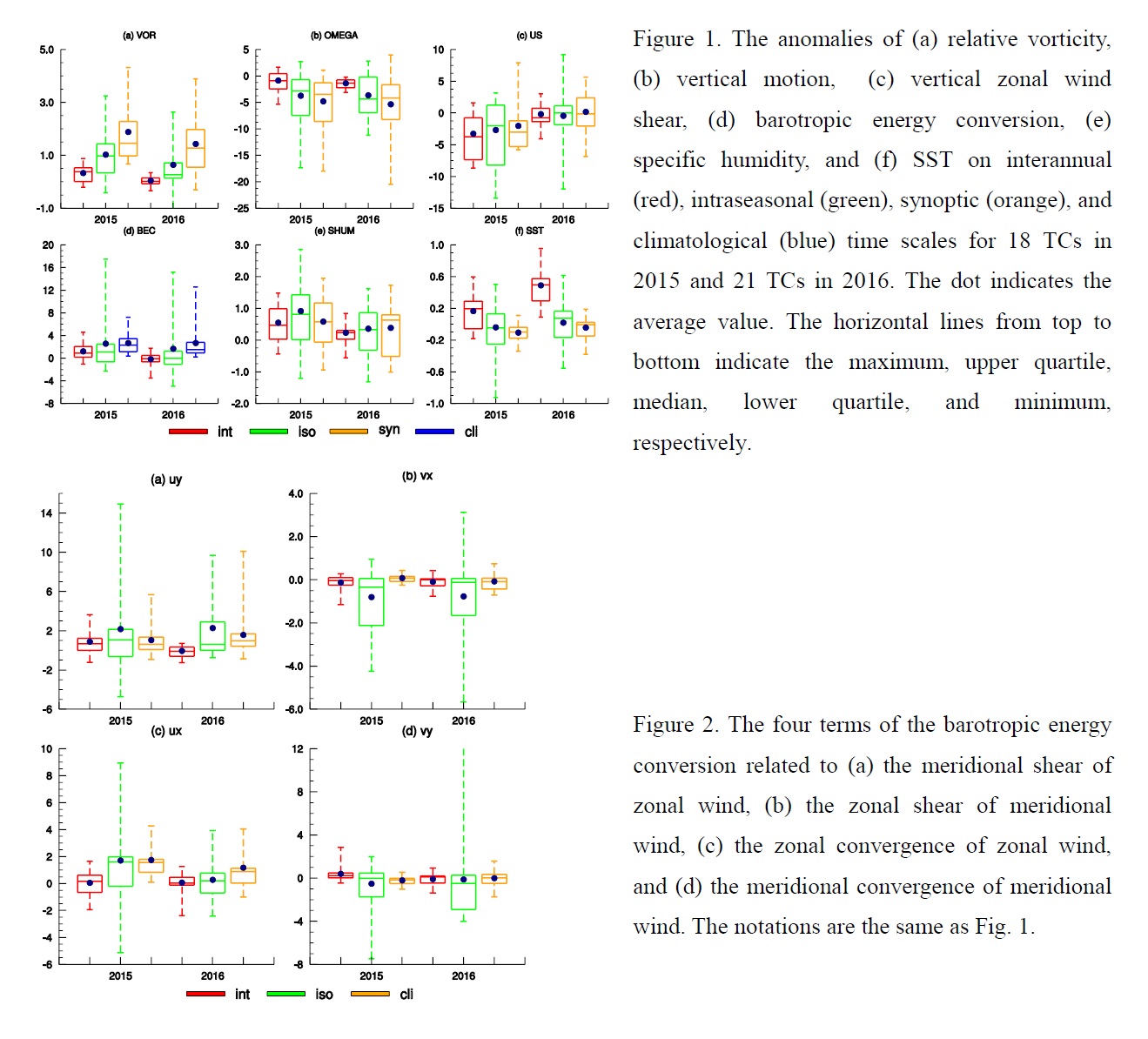
- A local instantaneous view of conditions for the TC genesis is adopted in the present study, which is distinct from previous studies of large-scale temporal averaged conditions.
- The positive contribution of lower-level vorticity and mid-level specific humidity is larger in 2015 than in 2016 on all the three time scales; the contribution of the barotropic energy conversion in relation to the meridional shear of interannual variations of zonal wind and the zonal convergence of intraseasonal variations of zonal wind are larger in 2015 than in 2016.
- The vertical wind shear on all the three time scales and sea surface temperature on the interannual time scale have a larger positive contribution to the TC genesis in 2016 than in 2015.
Zhuge et al. (2018)
Zhuge, X., and X. Zou, 2018: Summertime convective initiation nowcasting over Southeastern China based on Advanced Himawari Imager observations. J. Meteor. Soc. Japan, 96,
337-353.
https://doi.org/10.2151/jmsj.2018-041
Graphical Abstract
Highlights:
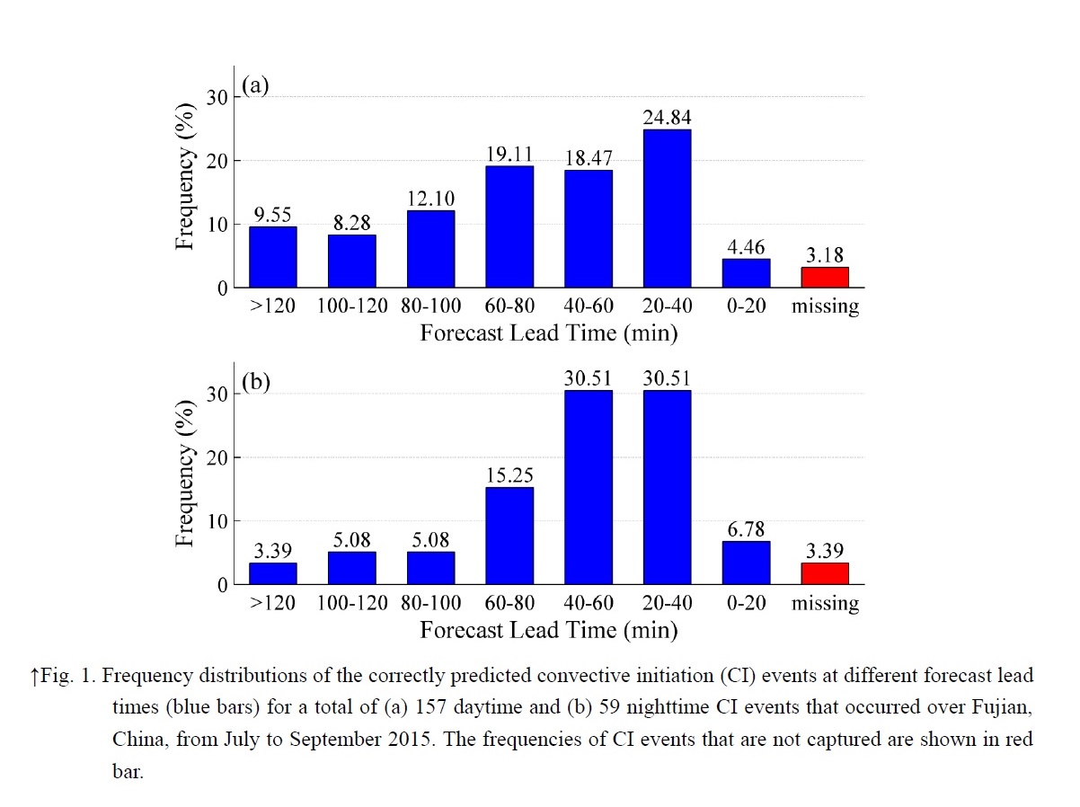
- Using high spatial and temporal resolution and multispectral data from the Advanced Himawari Imager (AHI) on board Japanese new-generation geostationary satellite Himawari-8, a standalone convective initiation (CI) nowcasting algorithm was developed in this study. The new algorithm is skillful in predicting the CI occurrences associated with warm-rain processes.
- The 216 CI events were identified from July to September 2015 by the CI nowcasting algorithm, which gives an averaged probability of detection (POD) of 96.82% and 96.61% at daytime and nighttime, respectively.
- The forecast lead time for the CI nowcasting algorithm varied from 14 to 120 minutes with a median value of 60 minutes. A cumulus object continually developed with a more rapid rate had a shorter forecast lead time. If a cumulus object grows slowly after the cloud-top temperature dropped below 10 °C, an early detection of CI is relatively easier and the forecast lead time is longer.
Tochimoto et al. (2018)
Tochimoto, E., and H. Niino, 2018: Structure and environment of tornado-spawning extratropical cyclones around Japan. J. Meteor. Soc. Japan, 96, 355-380.
https://doi.org/10.2151/jmsj.2018-043
Graphical Abstract
Highlights:
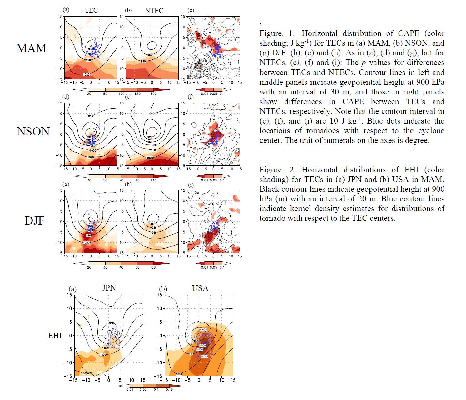
- This study used the JRA-55 reanalysis dataset to analyze the structure and environment of extratropical cyclones (ECs) that spawned tornadoes (tornadic ECs: TECs) between 1961 and 2011 in Japan.
- Our comparison of the structures and environmental parameters of TECs and non-tornadic ECs (NTECs) in each season indicates that CAPE for TECs in all seasons is larger than that for NTECs. Thus, thermodynamically more unstable environments seem to be important for tornado occurrences.
- A comparison of TECs between Japan and the United States (US) shows that SREH and CAPE are noticeably larger in the US. It is suggested that these differences occur because TECs in the US (Japan) develop over land (ocean), which exerts more (less) surface friction and diurnal heating.
Ueda et al. (2018)
Ueda, H., K. Miwa, and Y. Kamae, 2018: Seasonal modulation of tropical cyclone occurrence associated with coherent Indo-Pacific variability during decaying phase of El Niño. J. Meteor. Soc. Japan, 96, 381-390.
https://doi.org/10.2151/jmsj.2018-044
Graphical Abstract
Highlights:
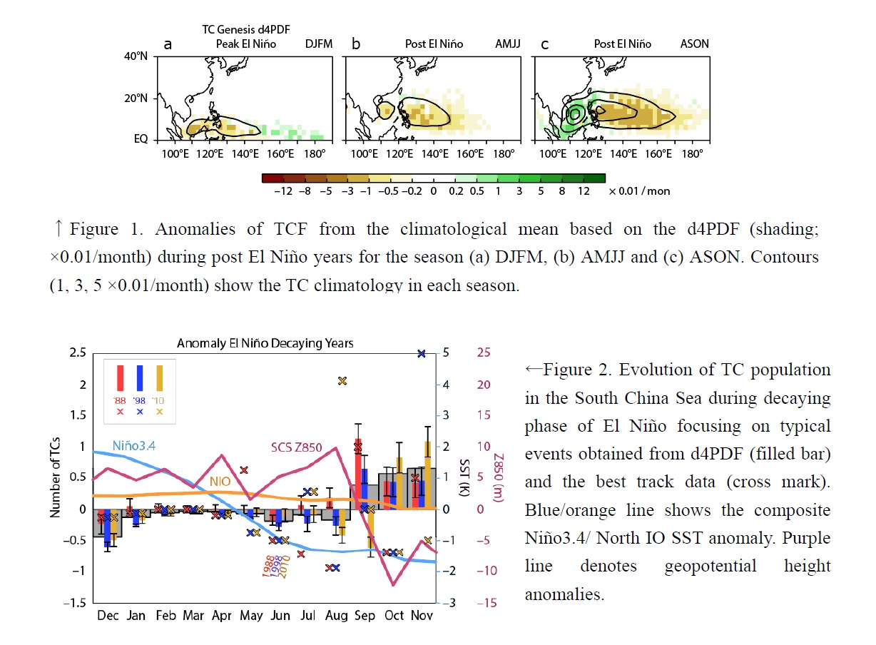
- The influence of ENSO together with the basin-wide warming in the tropical IO on TC activity are analyzed with particular focus on the decaying phase of El Niño.
- Our analysis reveals a sharp decrease in TC number in the tropical western Pacific during the post El Niño years until the early winter (Fig.1). The dominance of AAC over the western Pacific caused by the prolonged warming in the tropical IO is crucial factor rather than the local SSTA.
- In contrast, the South China Sea exhibits the opposing response during the post El Niño season from September, showing remarkable increase of the TC count. This can be ascribed to the weakening of subsidence anchored with the positive IO SST anomalies, which diminish in September (Fig. 2).
- We demonstrate that the effect of the IO warming should be taken into account when the ENSO is considered as an environmental factor for predicting TC activity.
Wang et al. (2018)
Wang, H., L. Qiu, X. Xie, Z. Wang, and X. Liu, 2018: Climate variability in monsoon and arid regions attributable to dynamic vegetation in a global climate model. J. Meteor. Soc. Japan, 96, 391-403.
https://doi.org/10.2151/jmsj.2018-047
Graphical Abstract
Highlights:
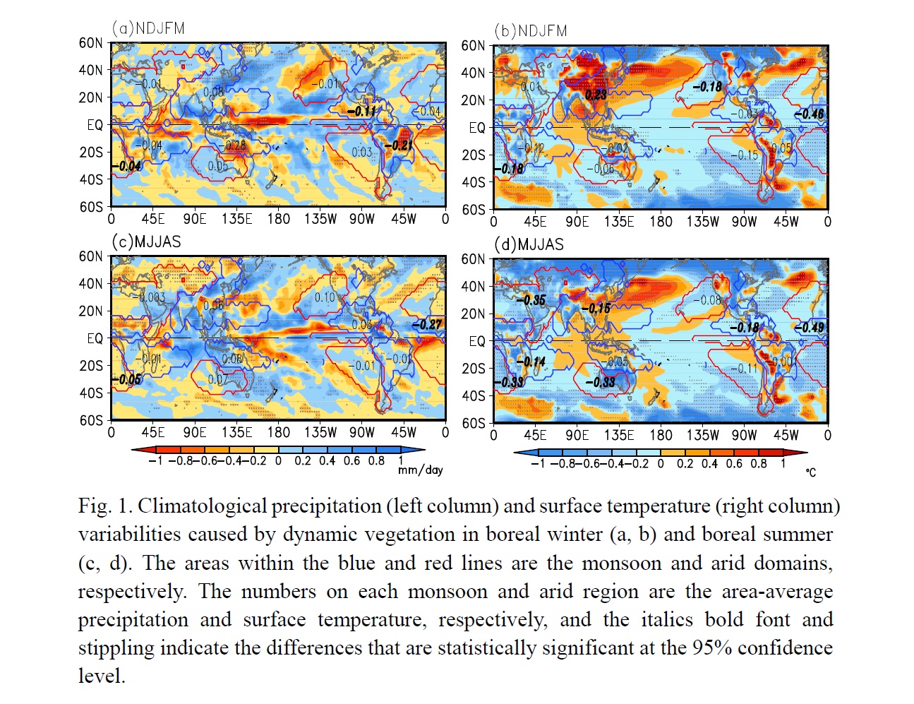
- This study investigated climate variability in global monsoon and arid regions because of dynamic vegetation by using NCAR’s Community Earth System Model with the Dynamic Global Vegetation Model.
- On the hemispheric scale, precipitation mainly increases in the Northern Hemisphere and decreases in the Southern Hemisphere in response to dynamic vegetation, while the surface temperature exhibits a consistent decrease.
- On regional scale, the response of climate variability to dynamic vegetation in the Asian monsoon region is clearly different from the other regions, and the dynamic vegetation can strengthen (weaken) the East Asian summer (winter) monsoon.
- Mechanistic analysis reveals that the difference in hemispheric and regional climate variations may be due to changes in the dynamic vegetation-induced moisture flux and net surface radiative forcing.
Notes and Correspondence
Misumi et al. (2018)
Misumi, R., Y. Uji, Y. Tobo, K. Miura, J. Uetake, Y. Iwamoto, T. Maesaka, and K. Iwanami, 2018: Characteristics of droplet size distributions in low-level stratiform clouds observed from Tokyo Skytree. J. Meteor. Soc. Japan, 96, 405-413.
https://doi.org/10.2151/jmsj.2018-040
Graphical Abstract
Highlights:
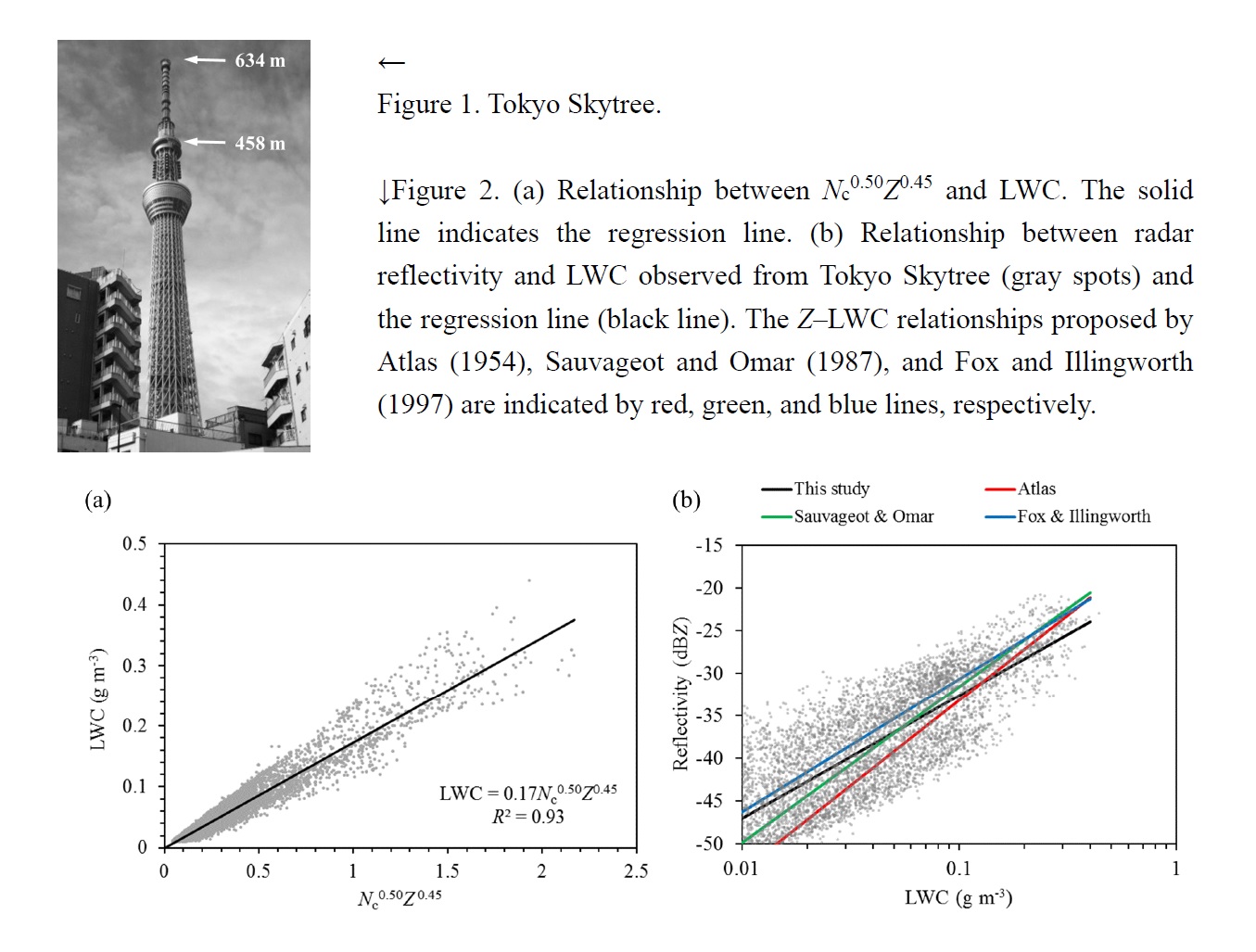
- Continuous observations of cloud droplet size distributions in low-level stratiform clouds have been conducted at a height of 458 m from Tokyo Skytree (Fig. 1; a 634-m-high broadcasting tower in Tokyo) using a cloud droplet spectrometer.
- The mean cloud droplet number concentration (Nc), average diameters, and effective diameters of cloud droplets in non-drizzling clouds were 213 cm−3, 7.3 μm, and 9.5 μm, respectively, which are close to the reported values for continental stratiform clouds.
- The relationship between liquid water content (LWC; g m−3), Nc (cm−3), and radar reflectivity (Z; mm6 m−3) was estimated as LWC = 0.17Nc0.50Z0.45, with a coefficient of determination (R2) of 0.93 (Fig. 2a).
- The Z-LWC relationship is close to those in the other studies when LWC < 0.4 g m−3 (Fig. 2b).
Takahashi (2018)
Takahashi, H. G., 2018: A systematic tropospheric dry bias in the tropics in CMIP5 models: Relationship between water vapor and rainfall characteristics. J. Meteor. Soc. Japan, 96, 415-423.
https://doi.org/10.2151/jmsj.2018-046
Graphical Abstract
Highlights:
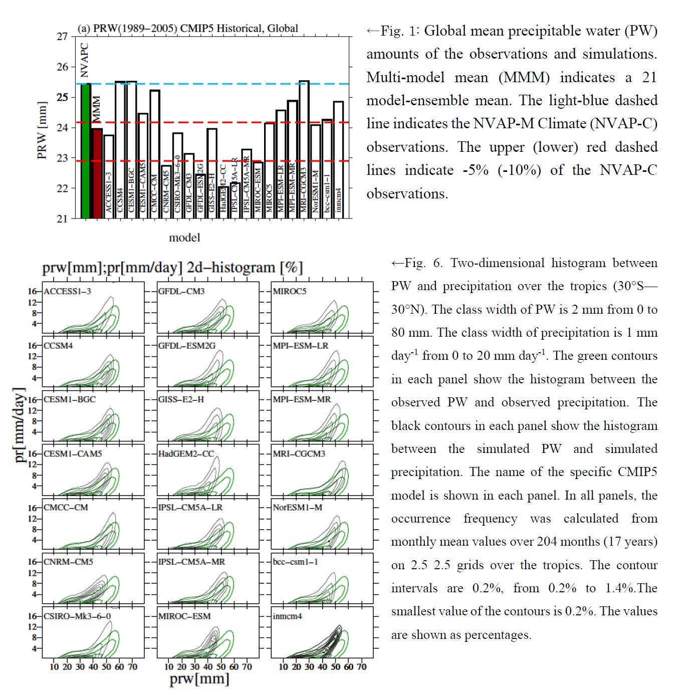
- This study investigated the absolute values of column-integrated water vapor (precipitable water; PW) in the CMIP5 climate models. We identified that global mean PW values are systematically much lower in CMIP5 models than in observations. This dry bias is most profound over the tropical ocean.
- The dry bias is partly due to biases in sea surface temperatures in the CMIP5-coupled climate models. However, the dry bias is also present in AMIP, which implies the existence of other factors.
- The relationship between PW and rainfall characteristics shows that rainfall occurs when water vapor levels are lower than in observations, particularly in models with a relatively strong dry bias, suggesting that the reproducibility of rainfall characteristics may be associated with the dry bias.
JMSJ, 2018, Vol. 96, No. 5 (October)
Articles
Chen et al. (2018)
Chen, Y., J. Wang, Y. Gao, X. Chen, H. Wang, and X.-Y. Huang, 2018: Refinement of the use of inhomogeneous background error covariance estimated from historical forecast error samples and its impact on short-term regional numerical weather prediction. J. Meteor. Soc. Japan, 96, 429-446.
https://doi.org/10.2151/jmsj.2018-048
Graphical Abstract
Highlights:
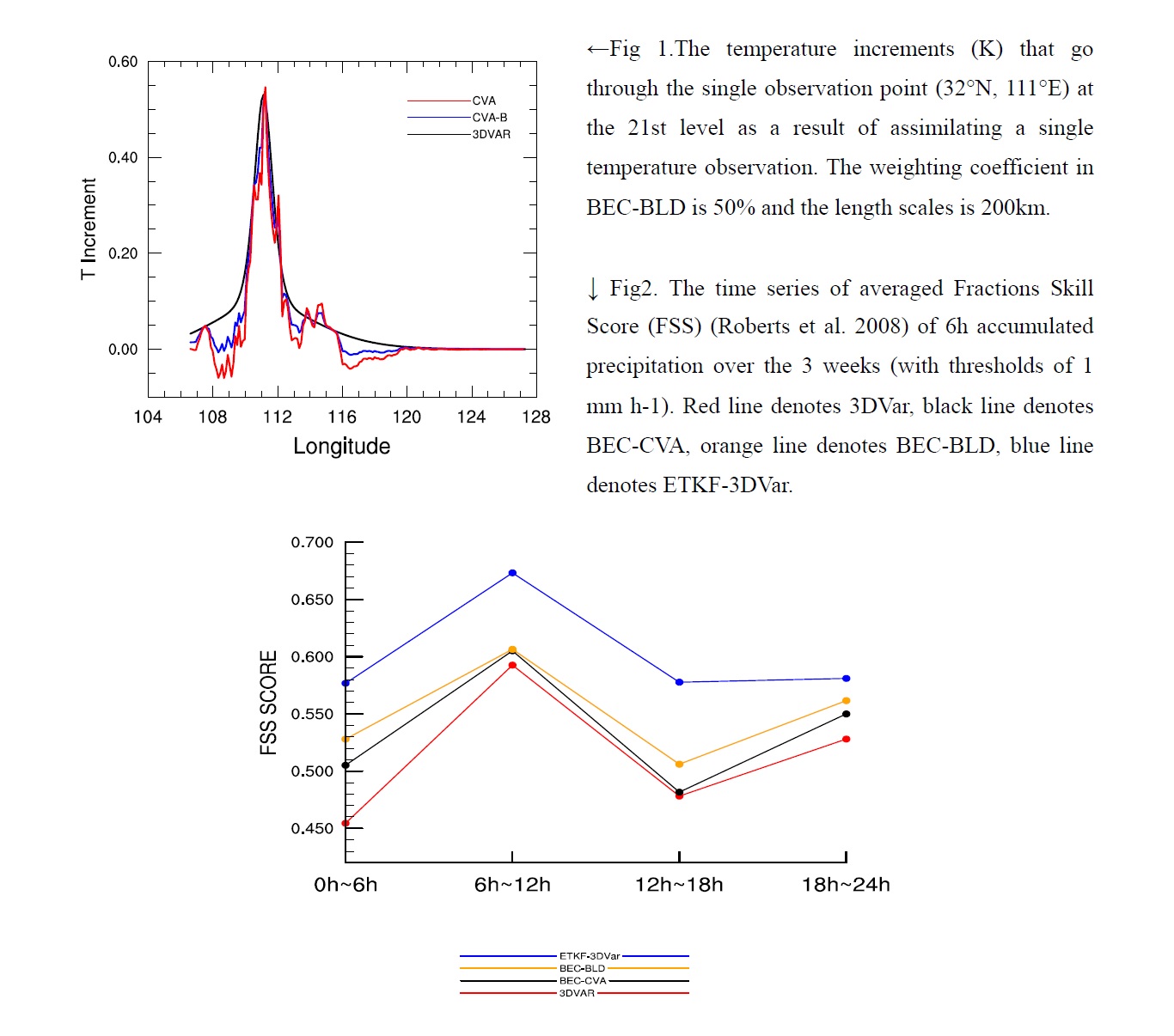
- The benefits of using a blending approach (BEC-BLD), which combines a static, homogeneous BEC and an inhomogeneous and anisotropic BEC, are assessed by conducting single observation assimilation experiments and continuous-cycling data assimilation and forecasting experiments covering a 3-week period.
- Single observation experiments indicate that the noise in the increments in the extended alpha control variable approach (BEC-CVA) can be somehow reduced by using BEC-BLD(Fig.1), while the inhomogeneous and multivariable correlations from BEC-CVA are still taken into account.
- The FSS of 6h accumulated precipitation over the 3 weeks show that BEC-CVA and BEC-BLD outperform the use of 3DVar. BEC-CVA and BEC-BLD underperform ETKF-3DVar, as expected.
Kang et al. (2018)
Kang, Y., J.-H. Jeong, C.-H. You, and D.-I. Lee, 2018: Structure and evolution of a convective system with bow echo associated with terrain on Jeju Island, Korea. J. Meteor. Soc. Japan, 96, 447-460.
https://doi.org/10.2151/jmsj.2018-050
Graphical Abstract
Special issue on Tokyo Metropolitan Area Convection Study for Extreme Weather Resilient Cities (TOMACS)
Highlights:
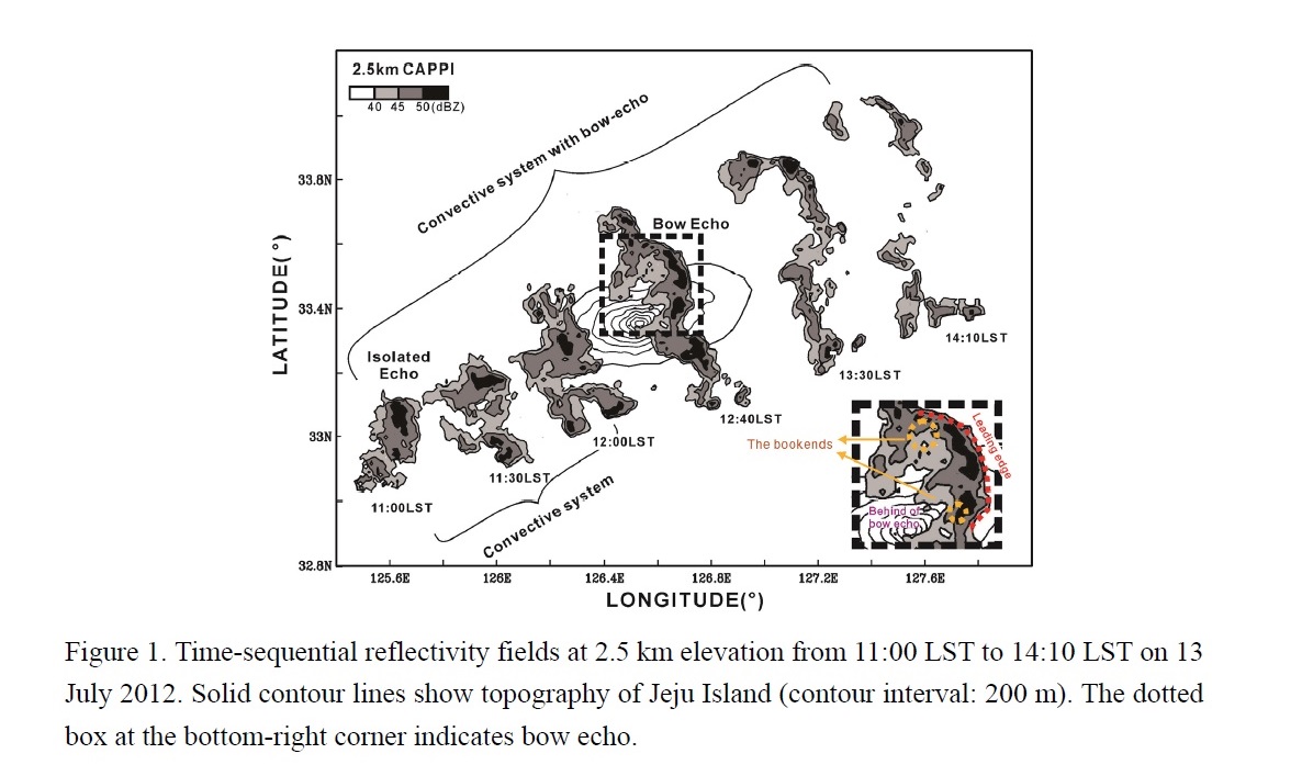
- The structure and evolution of convective system with bow echo on Jeju Island (isolated bell-shaped terrain), were investigated using dual-Doppler radar and surface observations (Fig. 1).
- The isolated bell-shaped terrain had a major indirect influence on the evolution of a convective system with bow echo. The rear-inflow jet (RIJ) in the system passing over the center of Island can get to strength on the lee side and descend with relatively dry air along the surface behind the bow echo.
- The cold pool on the lee side of mountain was generated by evaporative cooling over surface drier environment. The development of an RIJ and cold pool contributed the evolution of the convective system with bow echo in the northeastern side of Jeju Island.
Wang et al. (2018)
Wang, C.-C., G. T.-J. Chen, C.-H. Ngai, and K. Tsuboki, 2018: Case study of a morning convective rainfall event over southwestern Taiwan in the mei-yu season under weak synoptic conditions. J. Meteor. Soc. Japan, 96,Wang, C.-C., G. T.-J. Chen, C.-H. Ngai, and K. Tsuboki, 2018: Case study of a morning convective rainfall event over southwestern Taiwan in the mei-yu season under weak synoptic conditions. J. Meteor. Soc. Japan, 96, 461-484.
https://doi.org/10.2151/jmsj.2018-051
Graphical Abstract
Highlights:
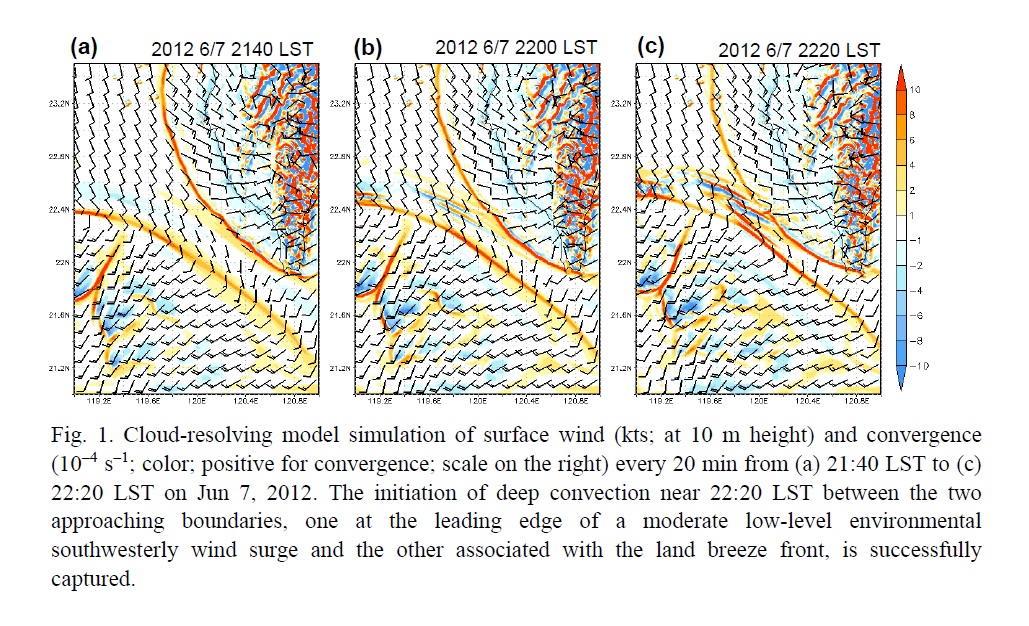
- A morning rainfall event in the coastal region over southwestern Taiwan on June 8, 2012 under weak synoptic conditions in the mei-yu season was investigated, with focus on its detailed initiation mechanism by means of mesoscale analysis and model simulations.
- Consistent with the observations, the model simulation successfully reproduced the initiation of deep convection offshore from Taiwan when two arc-shaped boundaries with convergence, one located at the leading edge of a moderate low-level southwesterly wind surge and the other associated with the westward-moving land breeze front, approach each other to about 40 km apart, between the two boundaries rather than along either one of them (Fig. 1).
- Both the above-mentioned approaching boundaries are required for a successful simulation of convective initiation, since neither the test with late arrival of the surge nor the one without Taiwan terrain can reproduce the convection responsible for the coastal morning rainfall.
- The offshore flow behind the land breeze front is a combination of land and mountain breezes and the steep topography of Taiwan is found to be crucial in its formation, as it becomes very weak in the test with the terrain removed.
JMSJ, 2018, Vol. 96, No. 6 (December)
Articles
Wada et al. (2018)
Wada, A., and R. Oyama, 2018: Relation of convective bursts to changes in the intensity of Typhoon Lionrock (2016) during the decay phase simulated by an atmosphere-wave-ocean coupled model. J. Meteor. Soc. Japan, 96, 489-509.
https://doi.org/10.2151/jmsj.2018-052
Graphical Abstract
Special Edition on Tropical Cyclones in 2015–2016
Highlights:
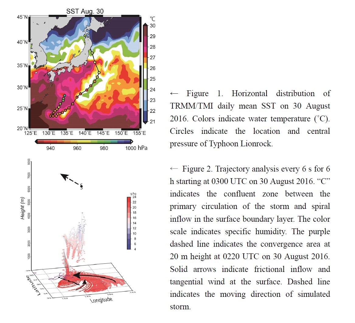
- The 3-km-mesh coupled atmosphere-wave-ocean model could simulate the occurrence of convective bursts of Typhoon Lionrock (2016) during the decay phase.
- Although SSC was induced by Lionrock (Fig. 1), the decrease in maximum wind speeds was paused due to high horizontal moisture fluxes around the frictional convergence area ahead of the storm, locally occurrences of upward moisture fluxes and CBs in the mid-to-upper troposphere (Fig. 2).
- An asymmetric storm with a relatively fast translation in mid-latitude is expected to rapidly increase maximum surface wind speeds on the upstream side under a favorable oceanic condition because vertical moisture fluxes and the number of CBs could increase around a surface frictional convergence area ahead of the storm.
- The number and distribution of CBs are sensitive to oceanic conditions and are considered to affect the storm-track simulation as well as maximum surface winds.
Ito et al. (2018)
Ito, R., T. Aoyagi, N. Hori, M. Oh’izumi, H. Kawase, K. Dairaku, N. Seino, and H. Sasaki, 2018: Improvement of snow depth reproduction in Japanese urban areas by the inclusion of a snowpack scheme in the SPUC model. J. Meteor. Soc. Japan, 96, 511-534.
https://doi.org/10.2151/jmsj.2018-053
Graphical Abstract
Highlights:
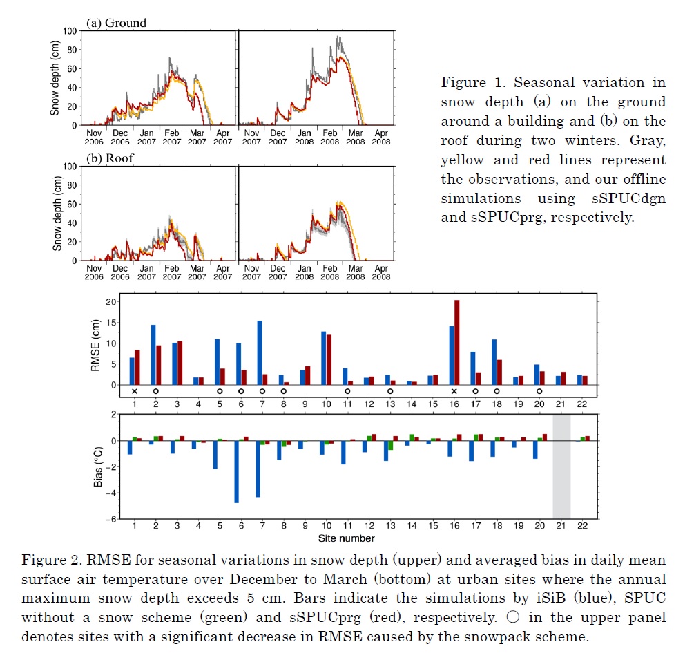
- To represent seasonal variations in urban snow cover, we enhanced a square prism urban canopy (SPUC) model by introducing two new snowpack schemes: one based on a diagnostic approach (sSPUCdgn) and the other on a prognostic approach (sSPUCprg).
- Our offline experiments indicated that both schemes are useful for the reproduction of a seasonal variation in snow depth and its peak on the ground around a building and on the building roof (Fig. 1), but sSPUCprg is needed when we wish to consider the processes in the snow layer.
- Compared with iSiB, the new scheme enabled SPUC to reduce the error of seasonal variations in snow depth significantly at urban sites with a cold bias above 1°C in iSiB (Fig. 2), by a different calculation method for the snow surface temperature from the method in iSiB and the inclusion of building walls without snow.
Kadoya et al. (2018)
Kadoya, T., and H. Masunaga, 2018: New observational metrics of convective self -aggregation: Methodology and a case study. J. Meteor. Soc. Japan, 96, 535-548.
https://doi.org/10.2151/jmsj.2018-054
Graphical Abstract
Highlights:
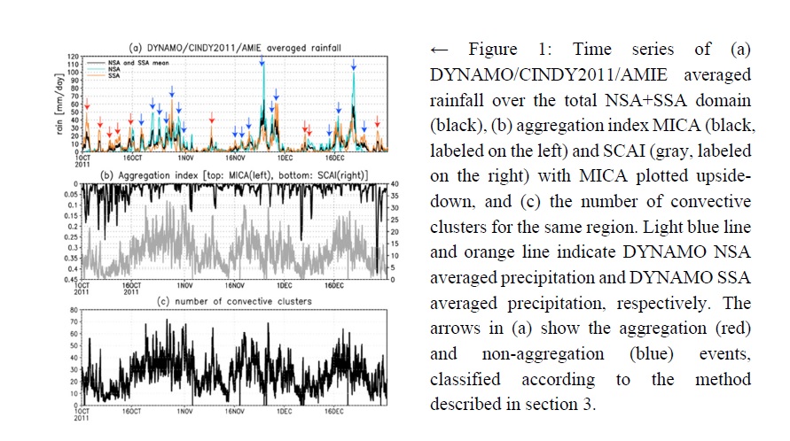
- A new observational measure, or the morphological index for convective self-aggregation (MICA), is developed to objectively detect the signs of convective self-aggregation on the basis of a simple morphological diagnosis of convective clouds in the satellite imagery. The proposed index is applied to infrared imagery from the Meteosat-7 satellite and is assessed with the sounding-array measurements in the tropics from CINDY2011/DYNAMO field campaign data in comparison with SCAI, an existing similar index (Fig. 1).
- The composite time series show that a drying proceeds over 6-12 hours as precipitation intensifies in the aggregation events. Such a drying is unclear in the non-aggregation events.
- The moisture budget balance is maintained in very different manners between the two adjacent sounding arrays for the aggregation events, in contrast to the non-aggregation events which lack such apparent asymmetry. These results imply the potential utility of the proposed metrics for future studies in search of convective self-aggregation in the real atmosphere.
Ito et al. (2018)
Ito, T., S. Nishimoto, and H. Kanehisa, 2018: Growing vortex Rossby waves with
azimuthal wavenumber one in quasigeostrophic system. J. Meteor. Soc. Japan, 96, 549-564.
https://doi.org/10.2151/jmsj.2018-055
Graphical Abstract
Highlights:
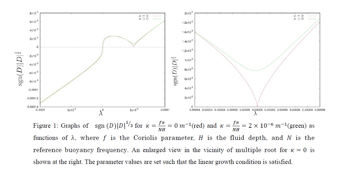
- Analytically solving the disturbance potential vorticity (PV) equation linearized about an axisymmetric vortex with radially piecewise uniform basic PV, we show that the vortex Rossby waves (VRWs) with azimuthal wavenumber one can grow exponentially in a quasi-geostrophic system (with disturbances projected on the first baroclinic mode) although they cannot do so in a barotropic system.
- The exponential growth of the VRWs, whose temporal dependence is expressed as ei λ t, is possible when the eigenequation D(λ) = 0 has non-real roots.
- For example, in the case of three regions of uniform basic PV, D(λ) is a cubic function whose graph is shown in Figure 1. The red line shows D(λ) in the absence of vertical interaction. Since the graph has two λ-intercepts one of which is degenerate, all the three roots are real. Hence, the VRWs cannot grow exponentially although they grow linearly because of the degenerate two roots. On the other hand, in the presence of vertical interaction which is possible in the quasi-geostrophic system, the graph of D(λ) shown by the green line in Figure 1 has only one λ -intercept, and the degenerate two roots become a complex conjugate pair. Hence, the VRWs can grow exponentially. Also in the case of more regions than three, it is shown in the same way that the VRWs can grow exponentially in the presence of vertical interaction.
Fukui et al. (2018)
Fukui, S., T. Iwasaki, K. Saito, H. Seko, and M. Kunii, 2018: A feasibility study on the high-resolution regional reanalysis over Japan assimilating only conventional observations as an alternative to the dynamical downscaling. J. Meteor. Soc. Japan, 96, 565-585.
https://doi.org/10.2151/jmsj.2018-056
Graphical Abstract
Highlights:
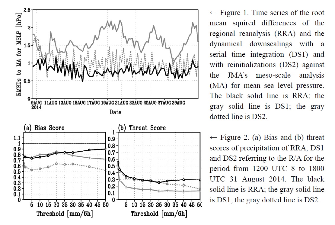
- The feasibility of regional reanalysis assimilating only conventional observations was investigated through a one-month regional reanalysis experiment. The system was designed to assimilate surface pressure observations and radiosonde upper-air observations into the Japan Meteorological Agency's nonhydrostatic model (NHM) that was nested in the Japanese 55-year reanalysis, by using the local ensemble transform Kalman filter (LETKF).
- The regional reanalysis overcame the problems of dynamical downscaling approaches with a serial long-term time integration and with frequent reinitializations. It reproduced actual synoptic-scale systems (Fig.1) and precipitation intensity (Fig.2a) and patterns (Fig.2b) better than the downscalings.
- The higher-resolution regional reanalysis (dx = 5 km) reproduced frequency of heavy precipitation and anomalous local fields affected by the topography, such as near-surface circulations and solar radiation associated with low-level clouds, better than the coarser reanalyses.
- The NHM-LETKF was optimized for long-term reanalysis by sensitivity experiments in terms of first guess, lateral boundary perturbations and ensemble size.
Yamashita et al. (2018)
Yamashita, Y., H. Naoe, M. Inoue, and M. Takahashi, 2018: Response of the Southern Hemisphere atmosphere to the stratospheric equatorial quasi-biennial oscillation (QBO) from winter to early summer. J. Meteor. Soc. Japan, 96, 587-600.
https://doi.org/10.2151/jmsj.2018-057
Graphical Abstract
Highlights:
- The mechanism by which the QBO modulates extratropical circulation over the Southern Hemisphere (SH) is poorly understood, as the various studies employed different height levels and metrics to define the phase of the QBO. Previous studies employed composite analysis that possibly includes signals other than the response to the stratospheric QBO.
- In this study, we examined the response of atmospheric circulation over the SH to the stratospheric QBO, defined by the equatorial zonal wind phases at middle- and lower-stratospheric levels.
- Regression coefficients associated with both middle- and lower-stratospheric QBO suggest an influence on the SH polar vortex from SH winter (June–August) through early summer (December) in the seasonal evolution.
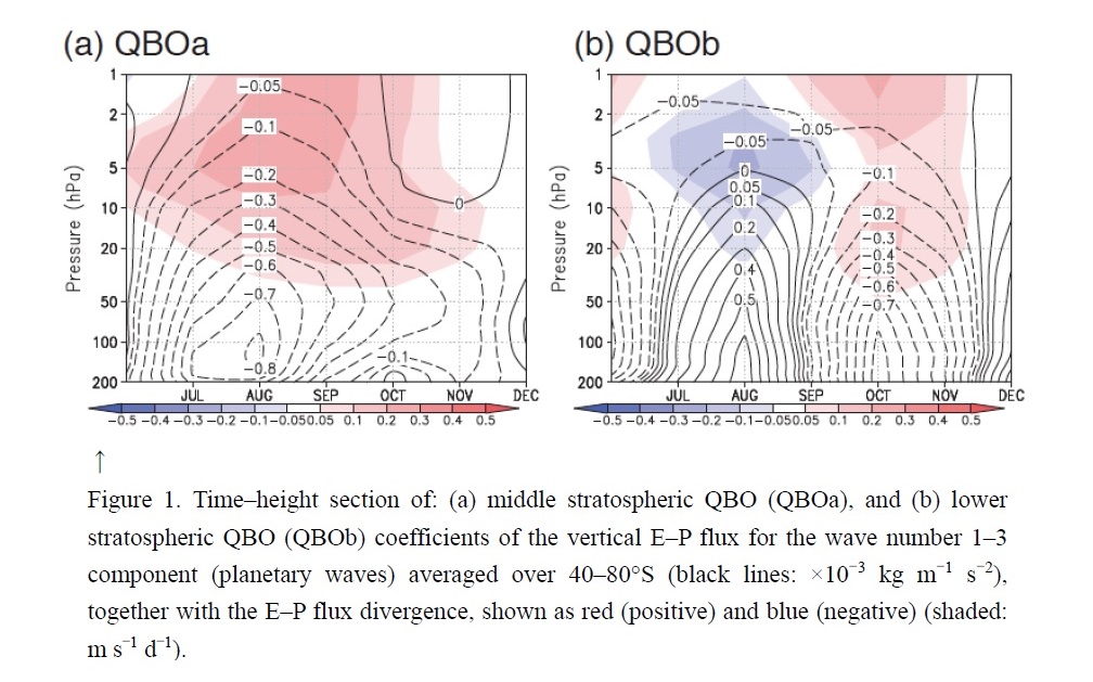
- One possible pathway is that the middle-stratospheric QBO results in the SH low-latitudes stratospheric response through the QBO-induced mean meridional circulation, leading to a high-latitude response from late winter (August) to spring (September–November). This corresponds to the delay in the shift-down of the strong polar vortex, leading to the suppression of planetary wave propagation from the extratropical troposphere into the stratosphere (Fig. 1a).
- The other possible pathway involves the response to lower-stratospheric QBO that induces the SH late winter increase in upward propagation of planetary waves from the extratropical troposphere to stratosphere (Fig. 1b).


