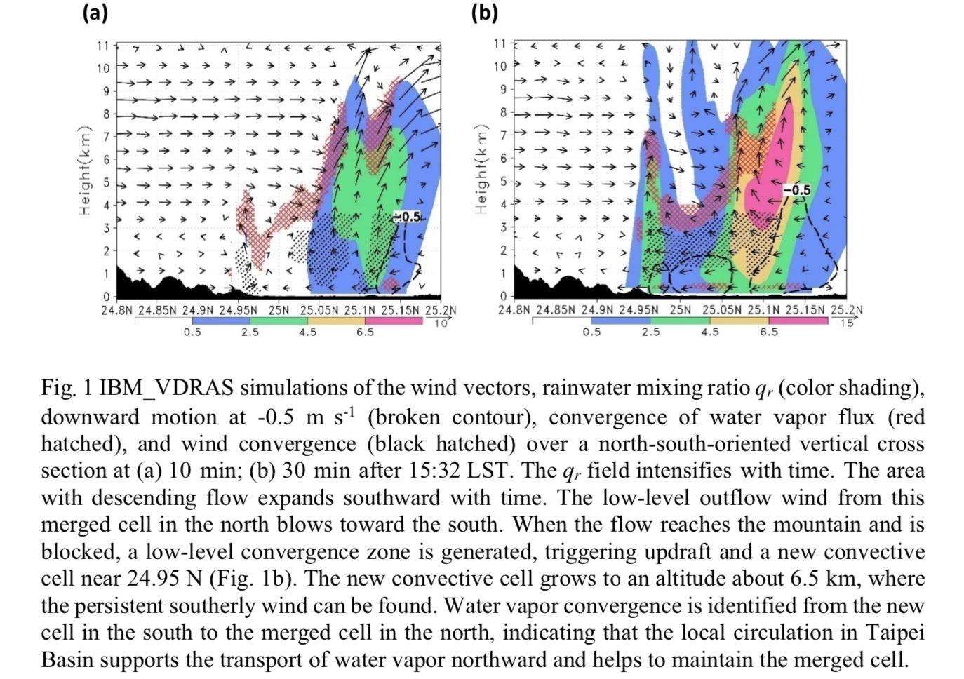
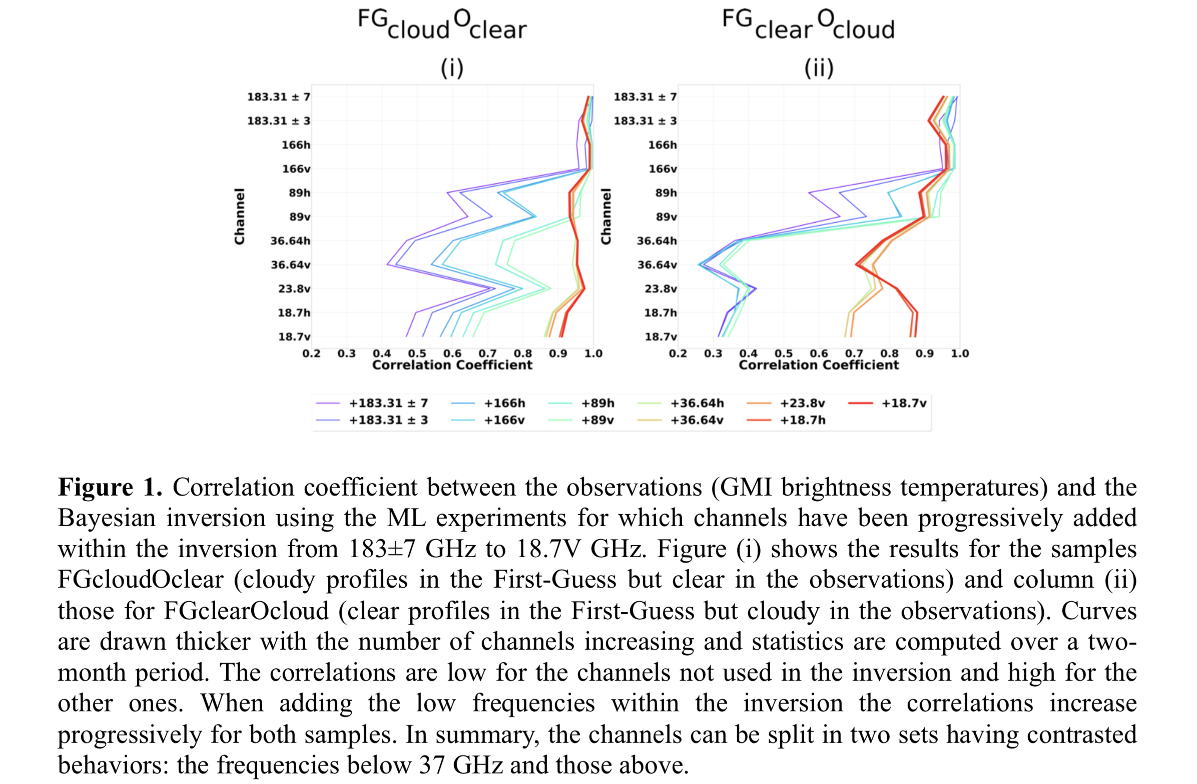
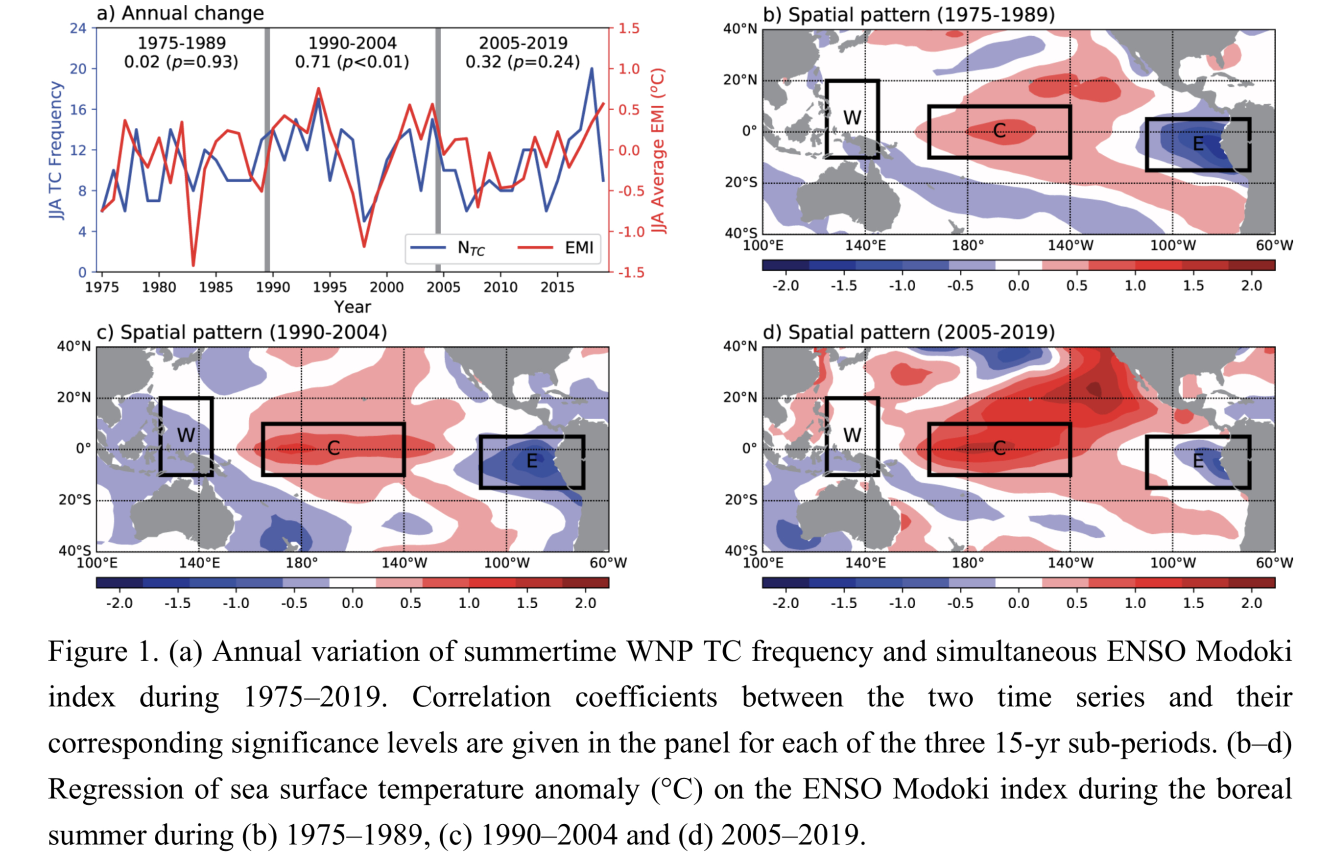
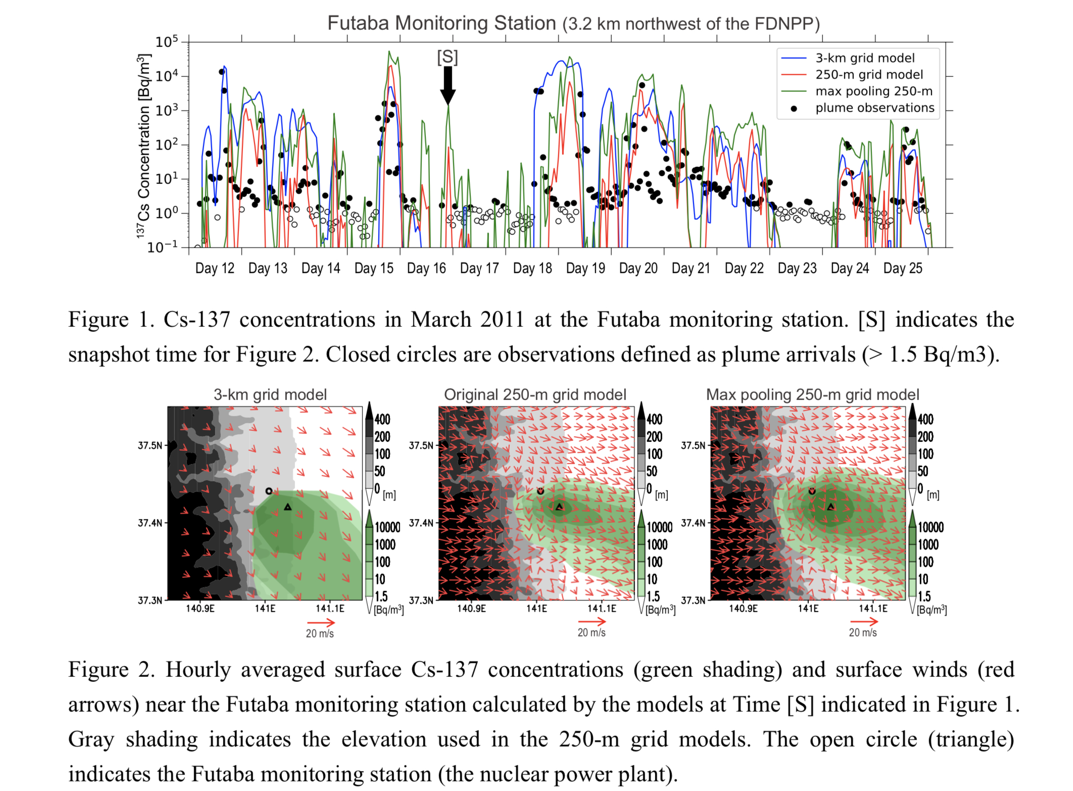
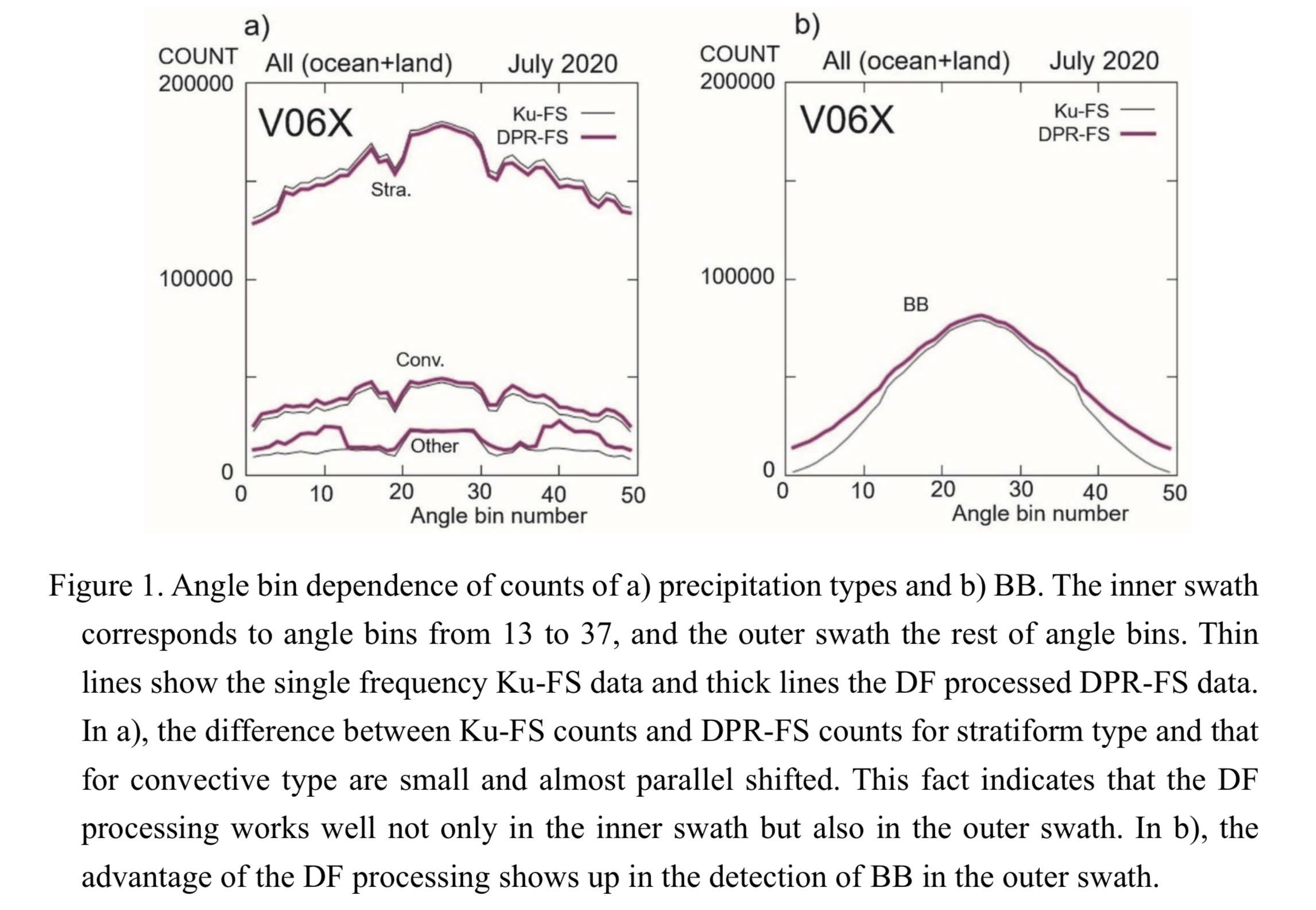
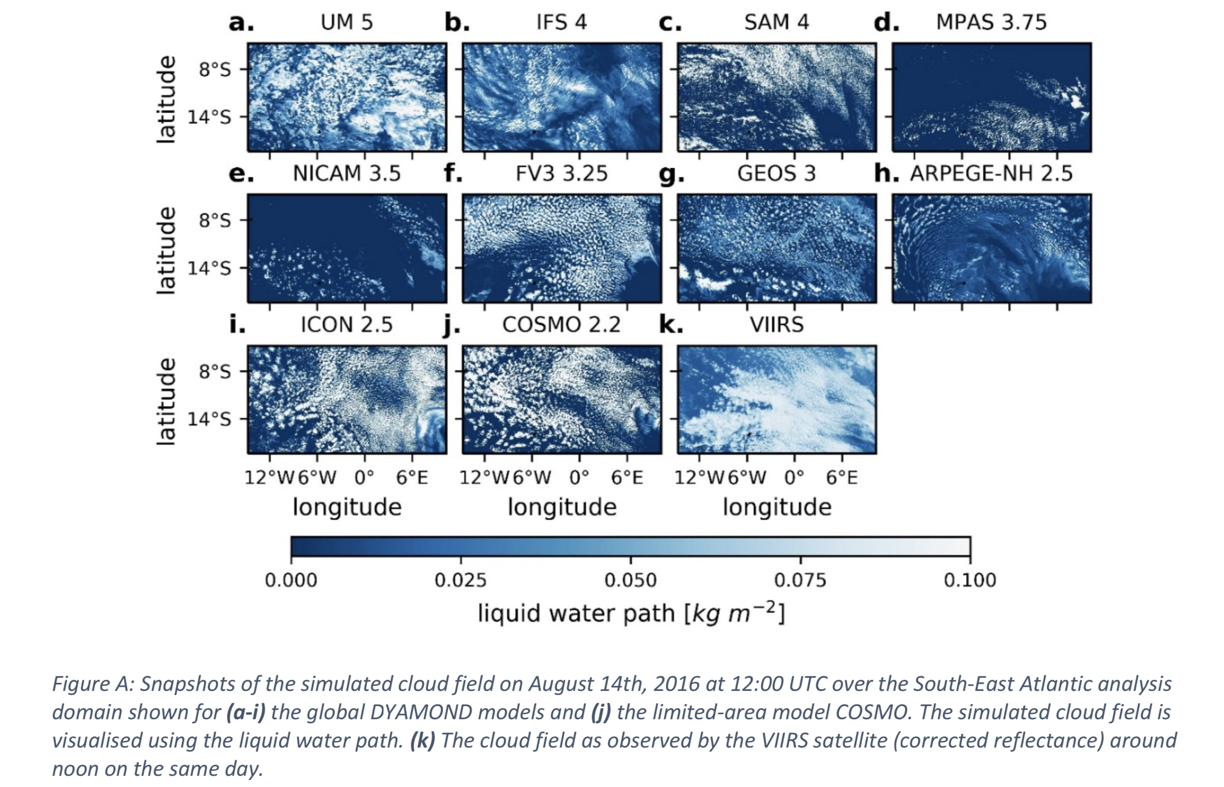
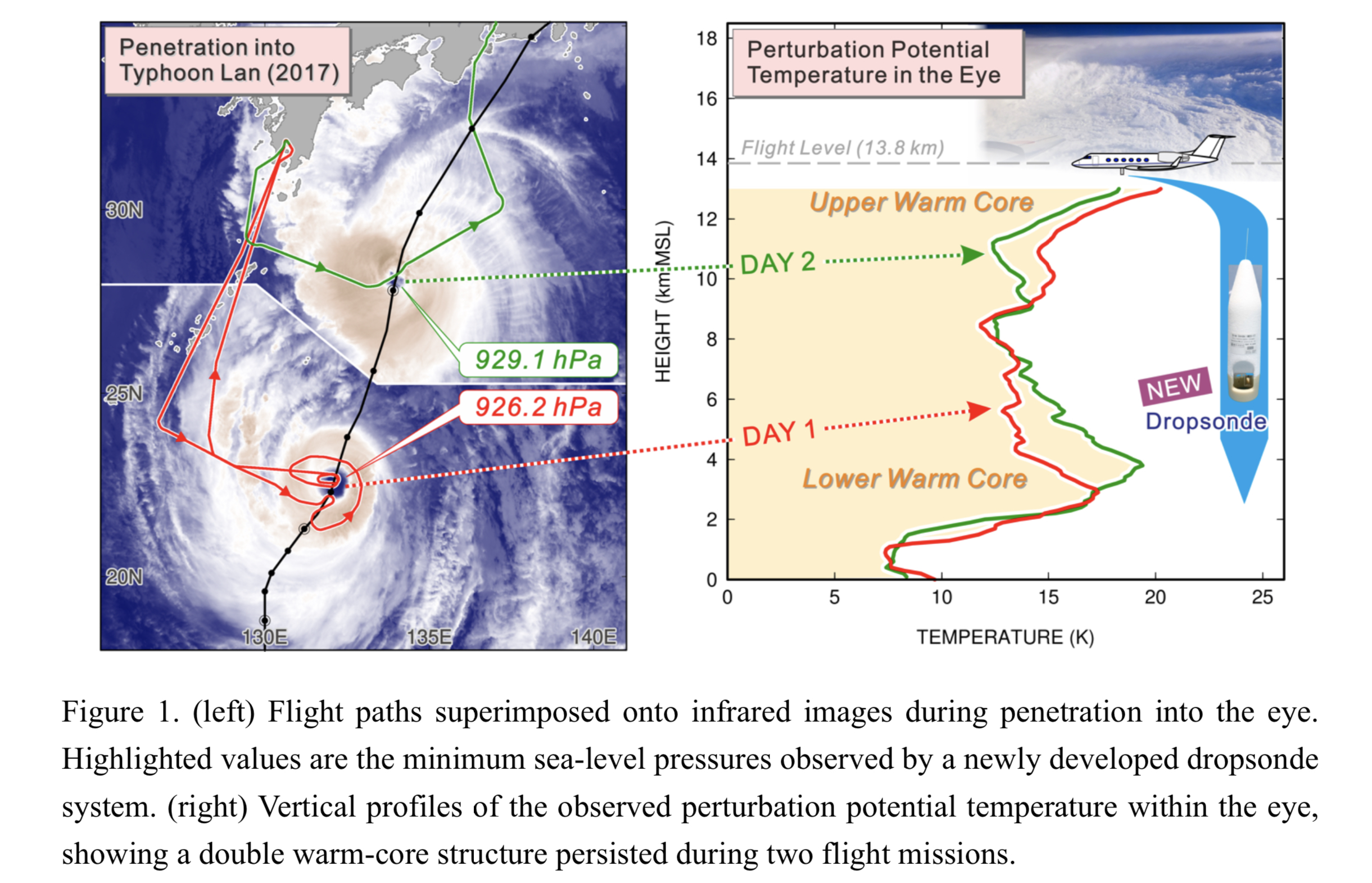
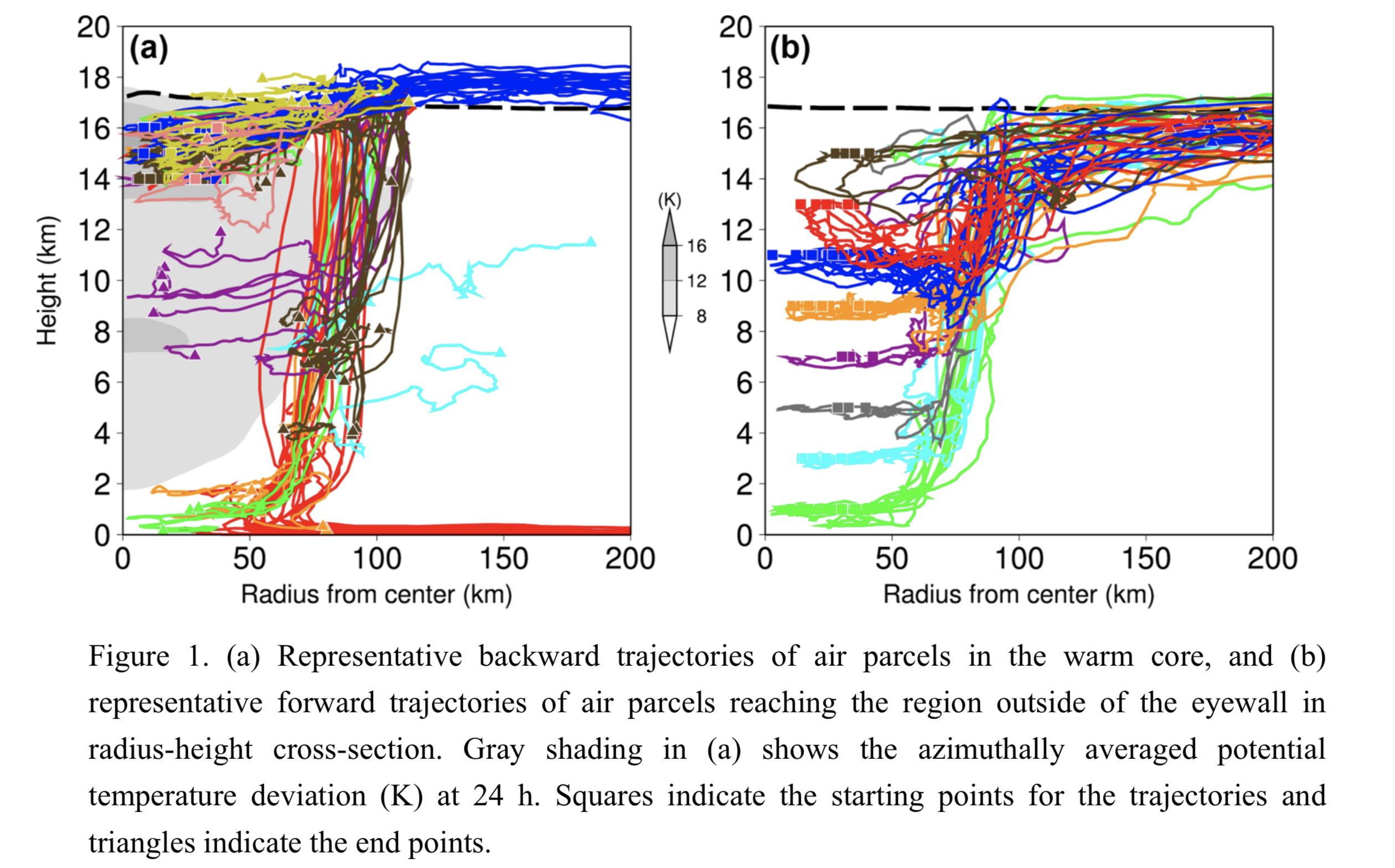
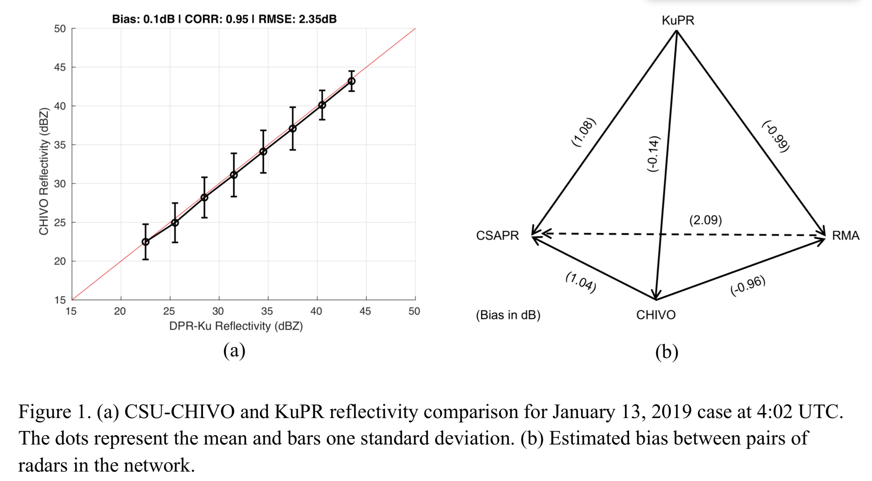
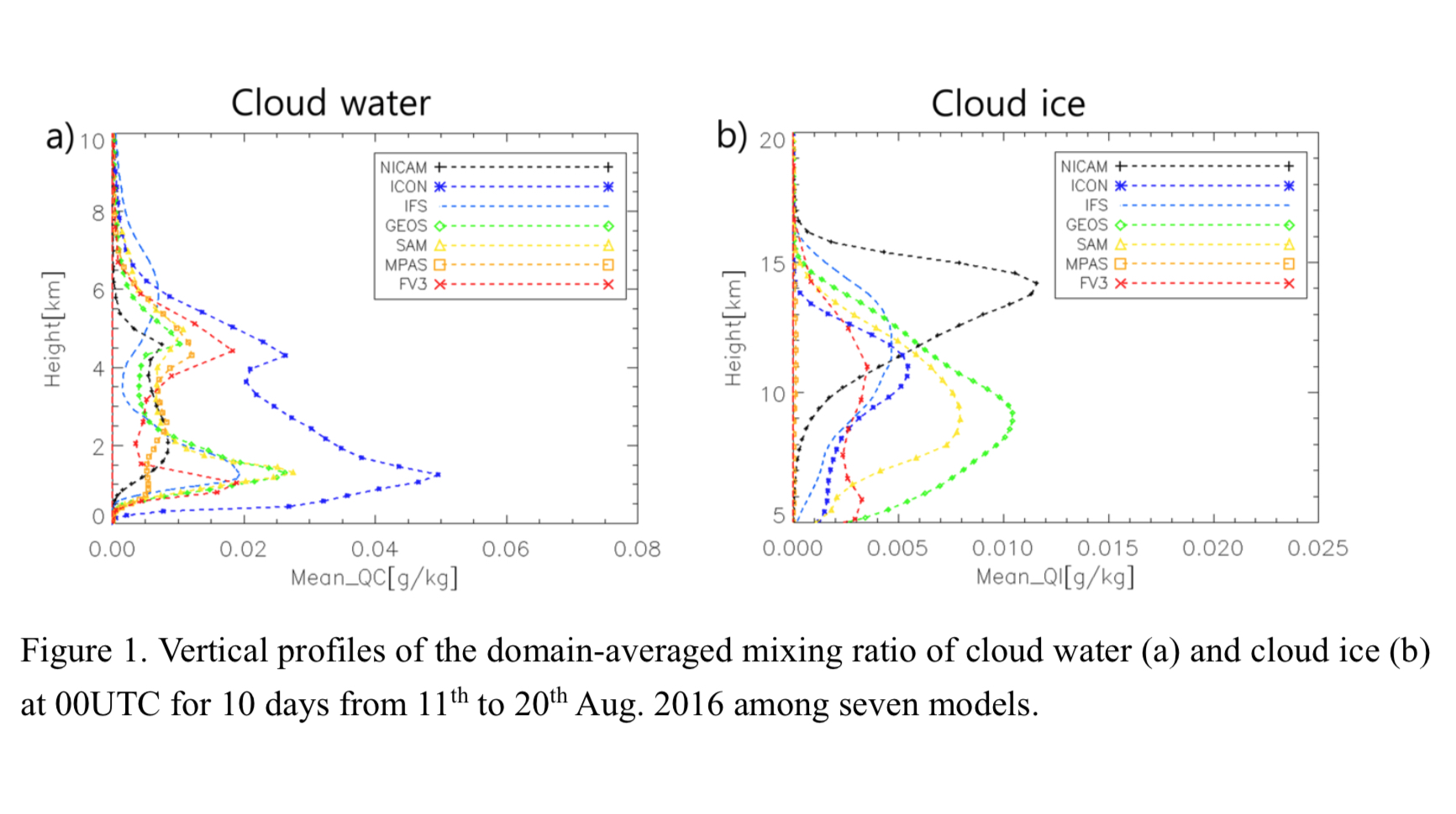
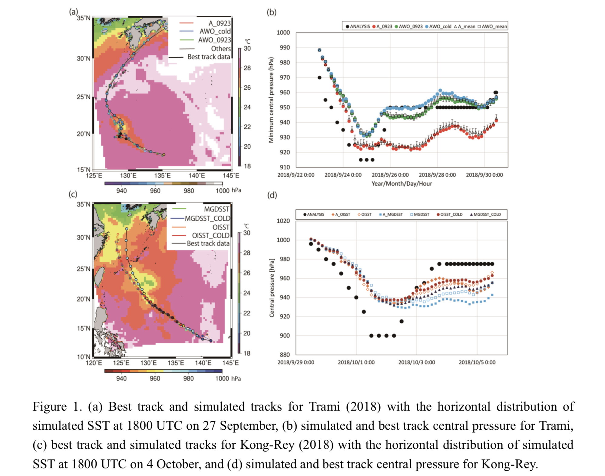
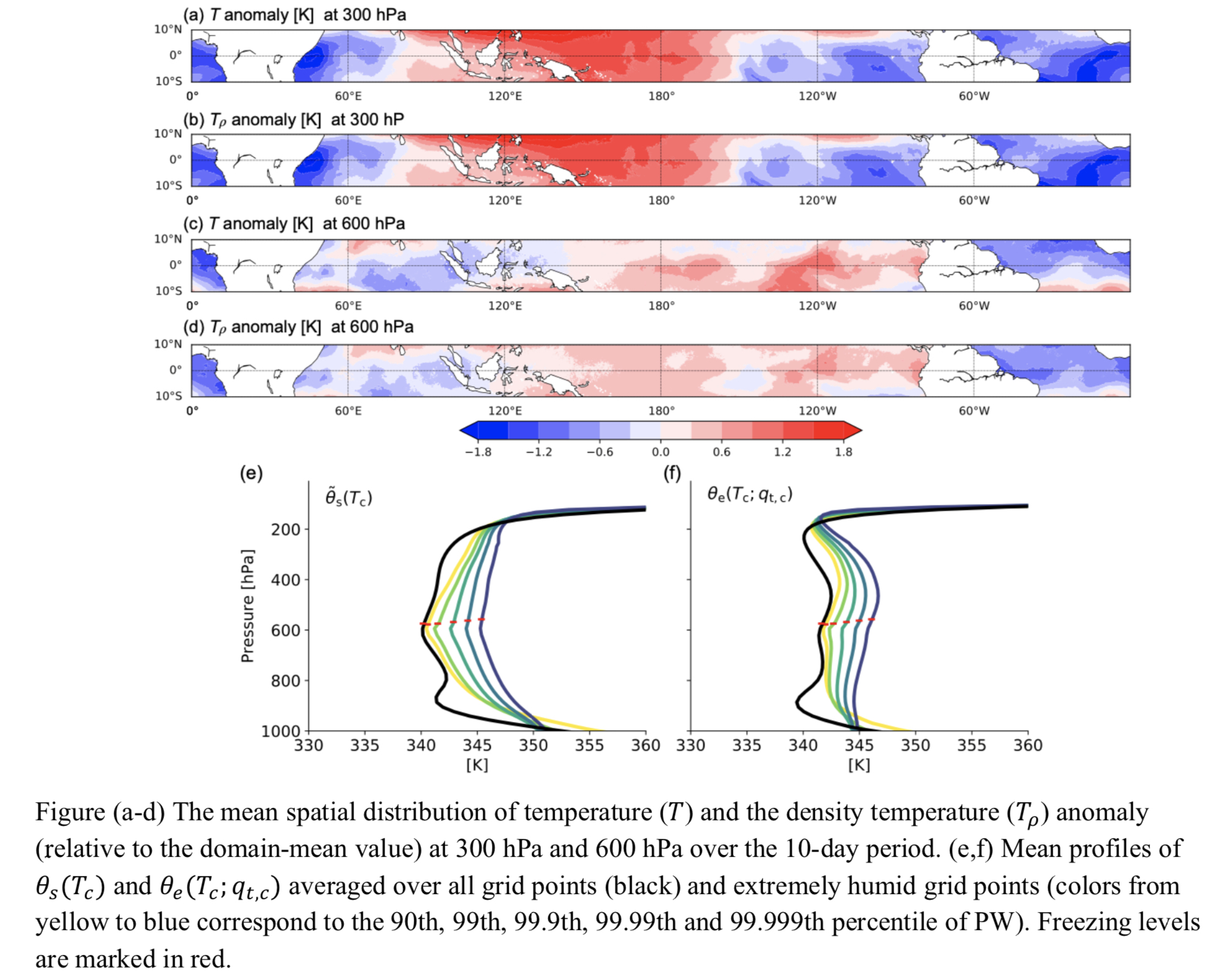
Graphical Abstract
JMSJ, 2021, Vol. 99, No. 1 (February)
Article: Special Edition on Global Precipitation Measurement (GPM): 5th Anniversary
Aoki and Shige (2021)
Aoki, S., and S. Shige, 2021: Large precipitation gradients along the south coast of Alaska revealed by spaceborne radars. J. Meteor. Soc. Japan, 99, 5-25.
Special Edition on Global Precipitation Measurement (GPM): 5th Anniversary
https://doi.org/10.2151/jmsj.2021-001
Graphical Abstract
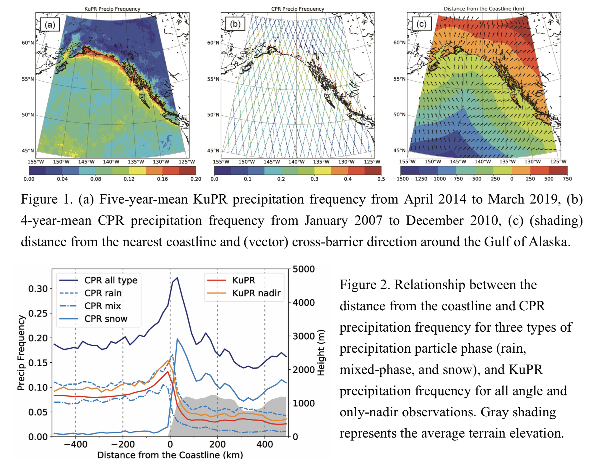
Plain Language Summary: At high latitudes, discriminating the phase of precipitation, as well as amount, is crucial in grasping the hydrological cycle. This study investigates the horizontal and vertical distribution of precipitation along the south coast of Alaska, using two spaceborne radars: the Dual-frequency Precipitation Radar (DPR) KuPR onboard the Global Precipitation Measurement (GPM) Core Observatory and the Cloud Profiling Radar (CPR) onboard CloudSat. It reveals that the precipitation phase and amount considerably change with the distance from the coastline.
Highlights:
- Precipitation frequencies evaluated by the two spaceborne radars have their maximum values in different region: the KuPR-detected frequency has over the coastal waters (−20–0 km), and the CPR-detected frequency has over the coastal mountains (20–40 km).
- The difference arises because light-to-moderate snowfall frequently occur over the mountains, whereas rainfall and mixed-phase precipitation are dominant over the ocean.
- Moisture flows associated with extratropical cyclones from the Gulf of Alaska are blocked by terrain and delayed around the coast, leading to long-lasting precipitation along the coastline.
Article
Suzuki et al. (2021)
Suzuki, K., T. Iwasaki, and T. Yamazaki, 2021: Analysis of systematic error in numerical weather prediction of coastal fronts in Japan’s Kanto Plain. J. Meteor. Soc. Japan, 99, 27-47.
https://doi.org/10.2151/jmsj.2021-002
Graphical Abstract
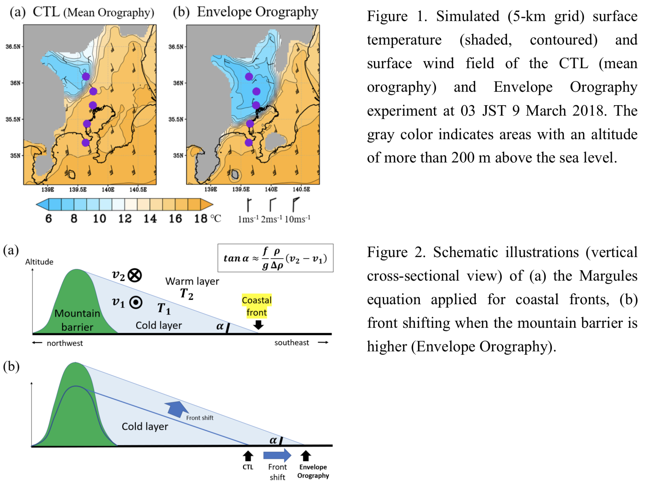
Plain Language Summary: Coastal fronts tend to be forecast on the inland side of their actual positions by the operational Numerical Weather Prediction (NWP with a horizontal grid spacing of 5 km) model at the Japan Meteorological Agency. This study confirms a systematic NWP error through statistical validations of coastal fronts, and the numerical experiments reveal that the systematic error may be caused primarily by an underestimation of the mountain barrier surrounding the Kanto Plain in the model.
Highlights:
- The operational NWP model with a 5-km grid spacing has a systematic error, with coastal fronts being shifted consistently to the inland side of their actual positions when the forecast period exceeds 5 hours.
- The numerical experiments suggest that the northwestward distance error of coastal fronts can be eliminated almost entirely by using the envelope orography (Fig. 1). The front shifting can be reasonably explained by the Margules equation (Fig. 2).
- The northwestward distance error, averaged over the three illustrative cases, was reduced by 27% and 37% by increasing the horizontal resolution from 5 km to 2 km and 1 km, respectively.
Article: Special Edition on Global Precipitation Measurement (GPM): 5th Anniversary
Le and Chandrasekar (2021)
Le, M. and V. Chandrasekar, 2021: Graupel and hail identification algorithm for the Dual-Frequency Precipitation Radar (DPR) on the GPM core satellite. J. Meteor. Soc. Japan, 99, 49-65.
Special Edition on Global Precipitation Measurement (GPM): 5th Anniversary
https://doi.org/10.2151/jmsj.2021-003
Graphical Abstract
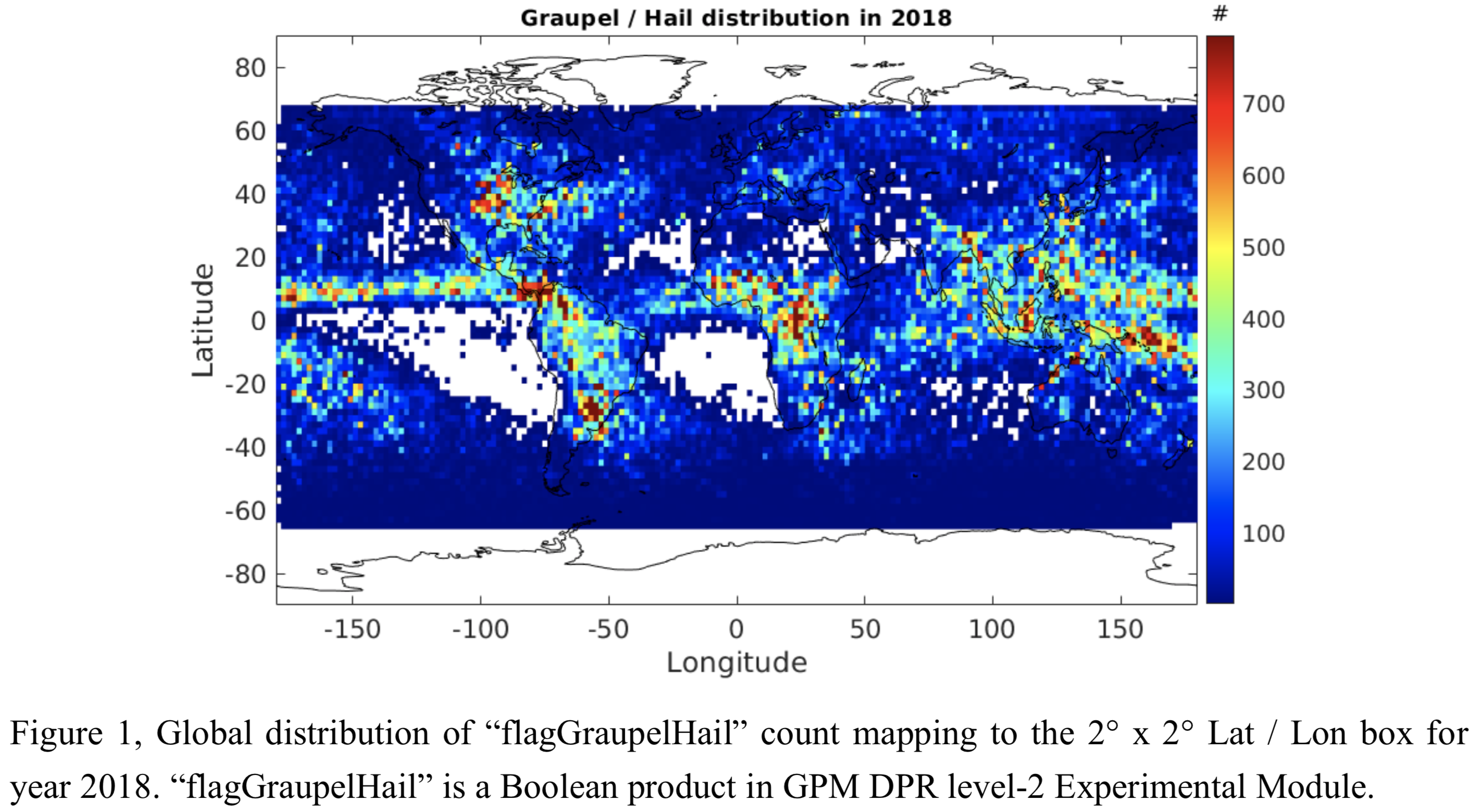
Plain Language Summary: This paper aims to develop a graupel and hail identification algorithm for GPM DPR. This algorithm is constructed using a precipitation type index (PTI) defined for DPR. The PTI is effective in separating hydrometeor types and is calculated using measurements of reflectivity, dual-frequency ratio, and storm top height data. The output of the algorithm is a Boolean product representing the existence of graupel or hail along with the vertical profile for each Ku- and Ka-band matched footprint. Cross validation is performed with the Weather Service Radar (WSR-88D) network over continental United States as well as during the Remote sensing of Electrification, Lightning, and Mesoscale/Microscale Processes with Adaptive Ground Observations (RELAMPAGO) experiment. Evaluation of this identification algorithm is performed on a global basis, which illustrates promising comparisons with the global lightning and hail precipitation maps generated using radar and radiometer.
Highlights:
- Graupel and hail identification algorithm is developed for GPM DPR in this paper. The Boolean output is available at each Ku- and Ka- matched footprint.
- Successful ground validations have been performed in both continental United States and RELAMPAGO campaign in South America.
- Figure 1 illustrates the global distribution of “flagGraupelHail” count mapping to the 2° x 2° Lat / Lon box for year 2018. Promising comparisons are found between this product and the global lightning and hail precipitation maps.
Article: Special Edition on Global Precipitation Measurement (GPM): 5th Anniversary
Yu et al. (2021)
Yu, T., V. Chandrasekar, H. Xiao, and S. S. Joshil, 2021: Snowfall estimation using dual-wavelength radar during the PyeongChang 2018 Olympics and Paralympic winter games. J. Meteor. Soc. Japan, 99, 67-77.
https://doi.org/10.2151/jmsj.2021-004
Graphical Abstract
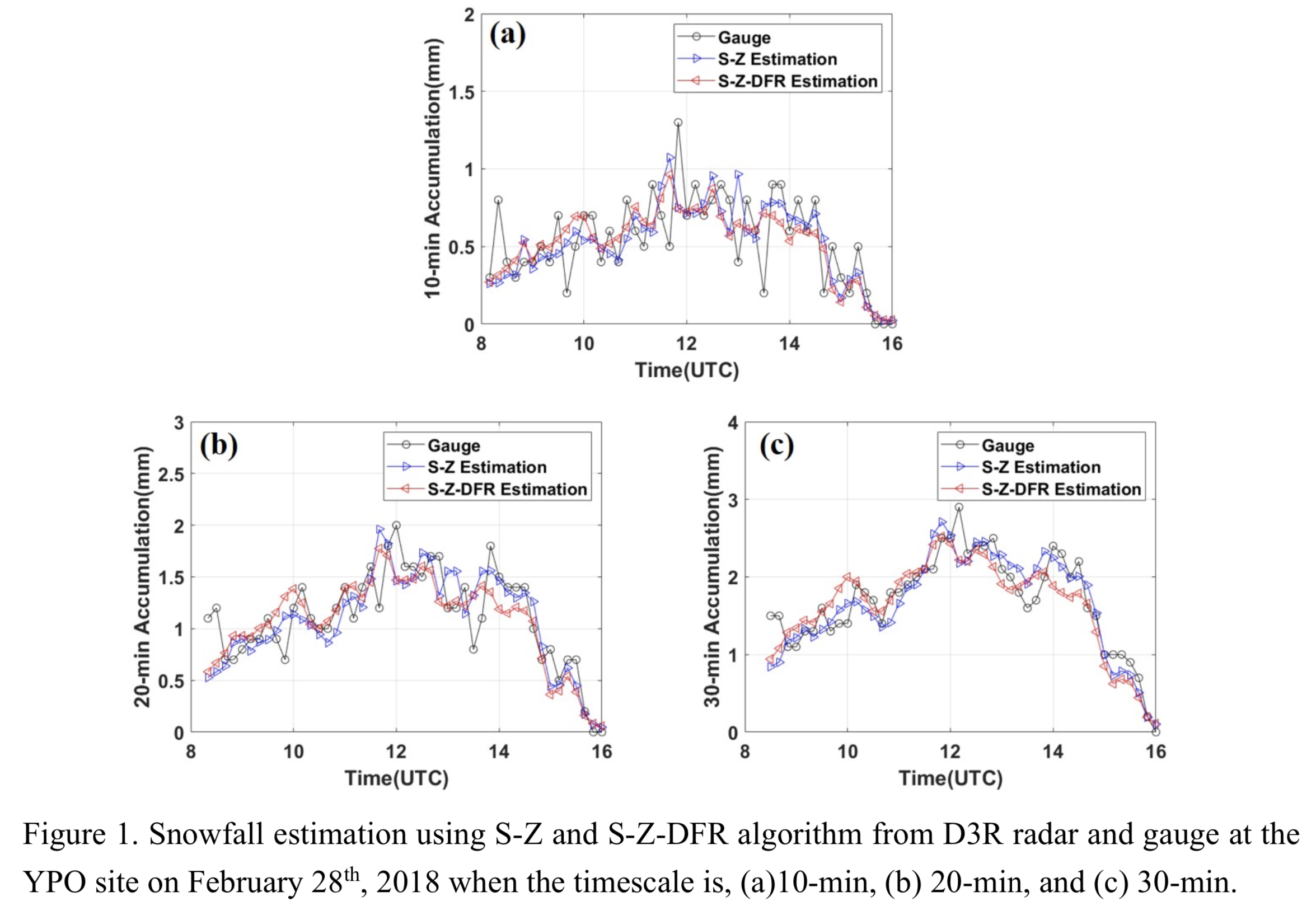
Plain Language Summary: This paper aims to develop S-Z and S-Z-DFR relationships for snow estimation using D3R radar in a coastal area. The velocity and diameter measured by the disdrometer is used to derive the snow density directly. Evaluation of the two snow estimation methods is performed at three sites (YPO, CPO, and DGW), and the results show that the radar snowfall estimation agrees well with the ground observations at the three sites and S-Z-DFR algorithm performs better compared with S-Z algorithm.
Highlights:
- Snowfall estimations using S-Z and S-Z-DFR algorithms for D3R radar are developed in this paper.
- Using the velocity and diameter measured by the disdrometer to derive the snow density directly is more accurate than using conventional power-law relationships between density and diameter.
- Snowfall estimation agrees well with the ground observations at the three sites and S-Z-DFR algorithm performs better compared with S-Z algorithm.
Article
Kusunoki and Mizuta (2021)
Kusunoki, S. and R. Mizuta, 2021: Future changes in rainy season over East Asia projected by massive ensemble simulations with a high-resolution global atmospheric model. J. Meteor. Soc. Japan, 99, 79-100.
https://doi.org/10.2151/jmsj.2021-005
Graphical Abstract
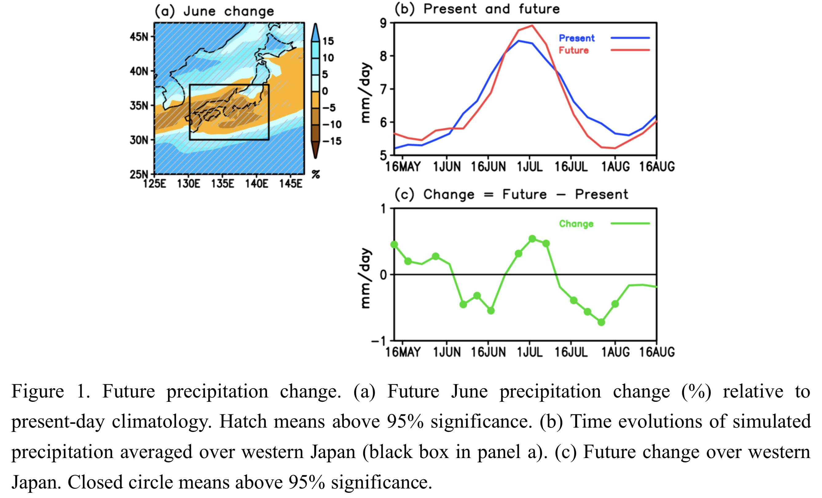
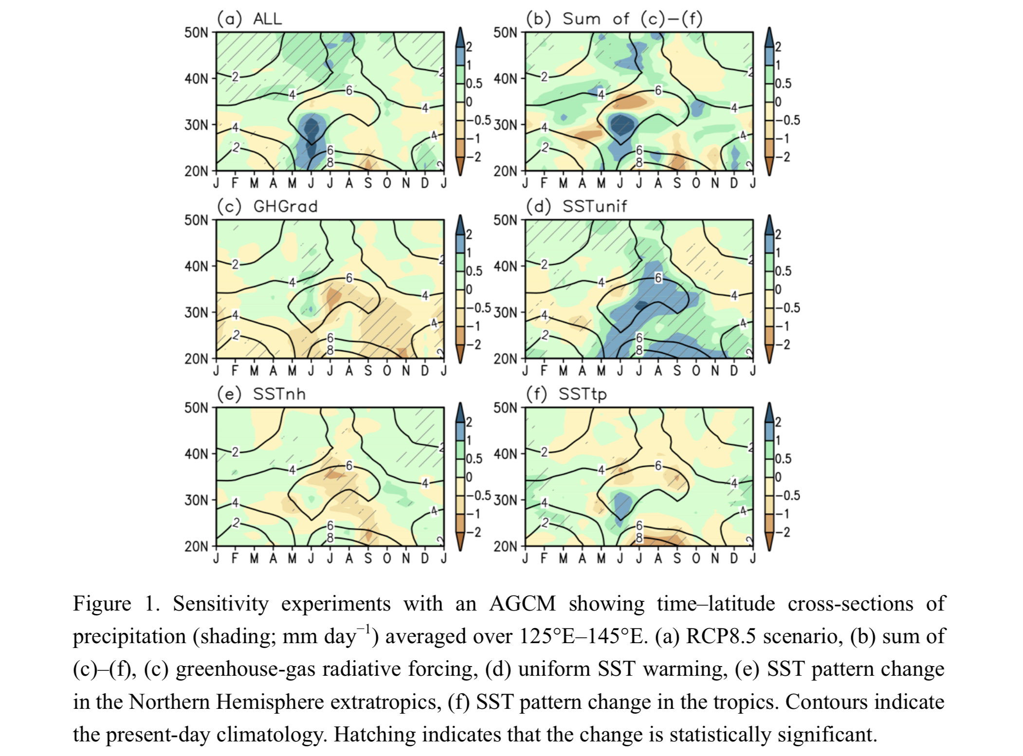
Plain Language Summary: Future changes in the rainy season in East Asia are projected based on massive ensemble simulations of about 100 members with a 60-km mesh global atmospheric model called the “Database for Policy Decision-Making for Future Climate Change (d4PDF)”. Summer precipitation will generally increase in most regions of East Asia, but will decrease over western Japan, where the onset of rainy season will delay and the retreat will occur earlier, resulting in a shorter rainy season.
Highlights:
- The performance of the 60-km mesh model used in this study was much higher than other institute's atmospheric models for simulating summer precipitation in East Asia.
- Precipitation will decrease in June around 30-35°N in China, Korea, and Japan.
- The decrease in precipitation in June in western Japan can be attributed to the counter-effect of the convergence of moisture to the south of Japan, originating in the southward shift of the West North Pacific Subtropical High.
- Frequency distribution directly derived from massive ensemble simulations at each grid point in June revealed that the most intense precipitation increases in some regions where moderate precipitation decreased in terms of simple ensemble averages.
Notes and Correspondence
Ohigashi et al. (2021)
Ohigashi, T., T. Maesaka, S. Suzuki, Y. Shusse, N. Sakurai, and K. Iwanami, 2021: Clear-air echoes observed by Ka-band polarimetric cloud radar: A case study on insect echoes in the Tokyo metropolitan area, Japan. J. Meteor. Soc. Japan, 99, 101-112.
https://doi.org/10.2151/jmsj.2021-006
Graphical Abstract
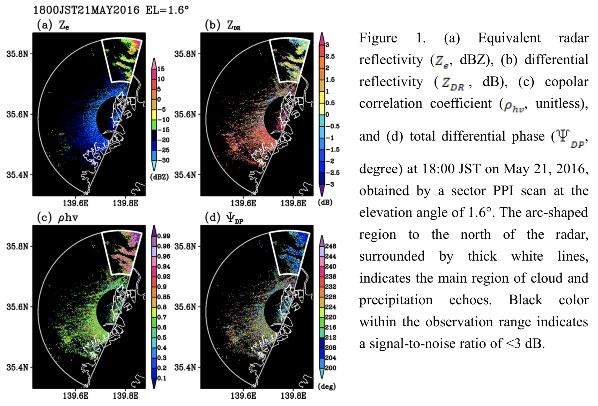
Plain Language Summary: The clear-air echoes (CAEs), that appeared on May 21, 2016 in the Tokyo metropolitan area, Japan, were investigated to establish the potential for distinguishing CAEs and hydrometeor echoes in the initial stage of cloud formation using Ka-band polarimetric cloud radar. The polarimetric variables obtained by Ka-band polarimetric cloud radar are useful in distinguishing between clear-air echoes and hydrometeor echoes.
Highlights:
- The upper limit of the equivalent radar reflectivity ( Ze ) and the distributions of the differential reflectivity ( ZDR ) and the copolar correlation coefficient ( ρhν ) were inconsistent with the characteristics of Bragg scattering observed by S-band (10-cm-wavelength) radar in previous studies.
- The larger , smaller , and larger variability of the total differential phase ( ΨDP ) in the range direction, associated with the horizontally widespread echoes, were consistent with the characteristics of insect echoes.
- TThe depolarization ratio, defined using ZDR and ρhν , could be effective in distinguishing this type of CAE and hydrometeor echoes observed by Ka-band polarimetric cloud radar.
Article: Special Edition on Years of the Maritime Continent (YMC)
Seiki et al. (2021)
Seiki, A., S. Yokoi, and M. Katsumata, 2021: The impact of diurnal precipitation over Sumatra Island, Indonesia, on synoptic disturbances and its relation to the Madden-Julian Oscillation. J. Meteor. Soc. Japan, 99, 113-137.
Special Edition on Years of the Maritime Continent (YMC)
https://doi.org/10.2151/jmsj.2021-007
Graphical Abstract
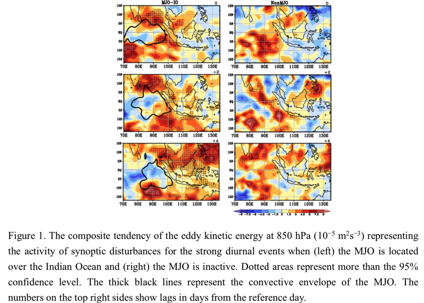
Plain Language Summary: Summary: Upscale effects of diurnal precipitation over Sumatra on synoptic disturbances are examined. The strong diurnal cycle is followed by the development of synoptic disturbances over the eastern Indian Ocean for several days, and apparent twin synoptic disturbances straddling the equator develop only when the convective center of the Madden–Julian Oscillation (MJO) lies over the Indian Ocean. Furthermore, the MJO events with the strong diurnal cycle tend to have continuing eastward propagation of active convection across the Maritime Continent, suggesting that the strong diurnal cycle facilitate the smooth eastward propagation of the MJO.
Highlights:
- Synoptic disturbances develop over the Indian Ocean after the strong diurnal cycle over Sumatra, suggesting that the diurnal cycle excites seed disturbances.
- Apparent twin synoptic disturbances straddling the equator develop only when the convective center of the MJO lies over the Indian Ocean.
- The strong diurnal cycle over Sumatra might facilitate the smooth eastward propagation of the MJO across the Maritime Continent.
Article
Huang et al. (2021)
Huang, X.-G., X.-D. Peng, J.-F. Fei, X.-P. Cheng, J.-L. Ding, and D.-D. Yu, 2021: Evaluation and error analysis of official tropical cyclone intensity forecasts during 2005-2008 for the western North Pacific. J. Meteor. Soc. Japan, 99, 139-163.
https://doi.org/10.2151/jmsj.2021-008
Graphical Abstract
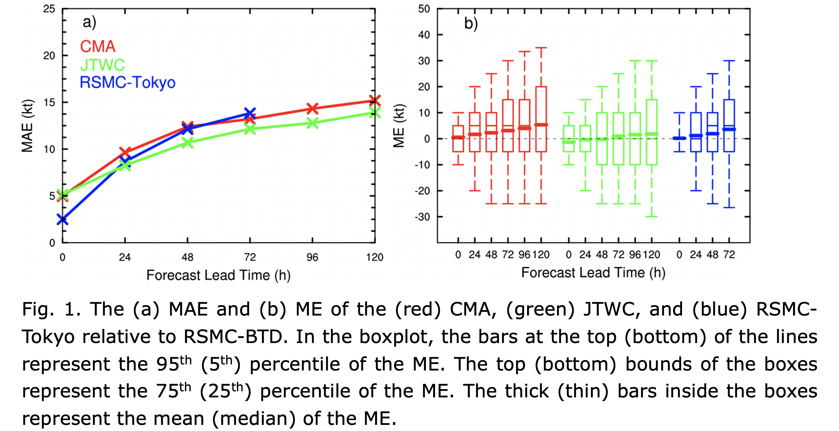
Plain Language Summary: This study systematically evaluates the accuracy, trends, and error sources of three centers as the China Meteorological Administration (CMA), Joint Typhoon Warning Center (JTWC), and Regional Specialized Meteorological Center Tokyo-Typhoon Center (RSMC-Tokyo) for western North Pacific tropical cyclone (TCs) intensity forecasts between 2005 and 2018. The results of the study confirm the steady progress of the intensity forecast in the three centers in recent years. Meanwhile, the intensity forecast skill still needs to be greatly improved for the rapidly intensification (RI) TCs.
Highlights:
- The TC intensity forecast accuracy performances are as follows: 24–48 h, JTWC > RSMC-Tokyo > CMA; 72 h, JTWC > CMA > RSMC-Tokyo; and 96–120 h, JTWC > CMA.
- The improvements in TC intensity forecasting are marginal but steady for all three centers. The 24–72 h improvement rate is approximately 1%–2% yr−1.
- The three centers generally have higher skill scores associated with forecasting of rapid weakening (RW) events than rapid intensification (RI) events. Overall, the three centers are not skillful in forecasting RI events more than three days in advance.
Article: Special Edition on Extreme Rainfall Events in 2017 and 2018
Unuma and Takemi (2021)
Unuma, T., and T. Takemi, 2021: Rainfall characteristics and their environmental conditions during the heavy rainfall events over Japan in July of 2017 and 2018. J. Meteor. Soc. Japan, 99, 165-180.
Special Edition on Extreme Rainfall Events in 2017 and 2018
https://doi.org/10.2151/jmsj.2021-009
Graphical Abstract
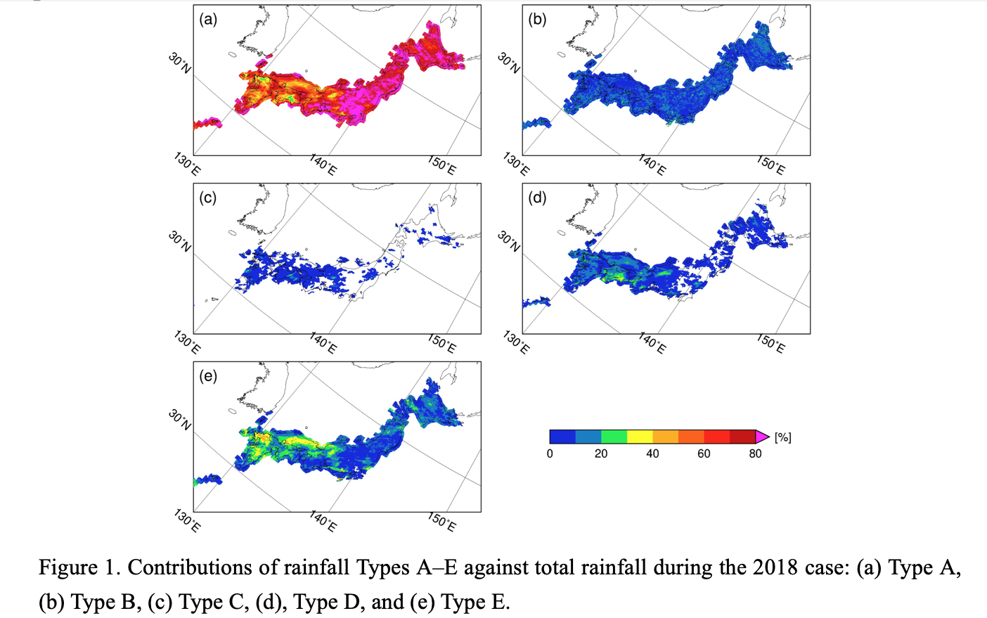
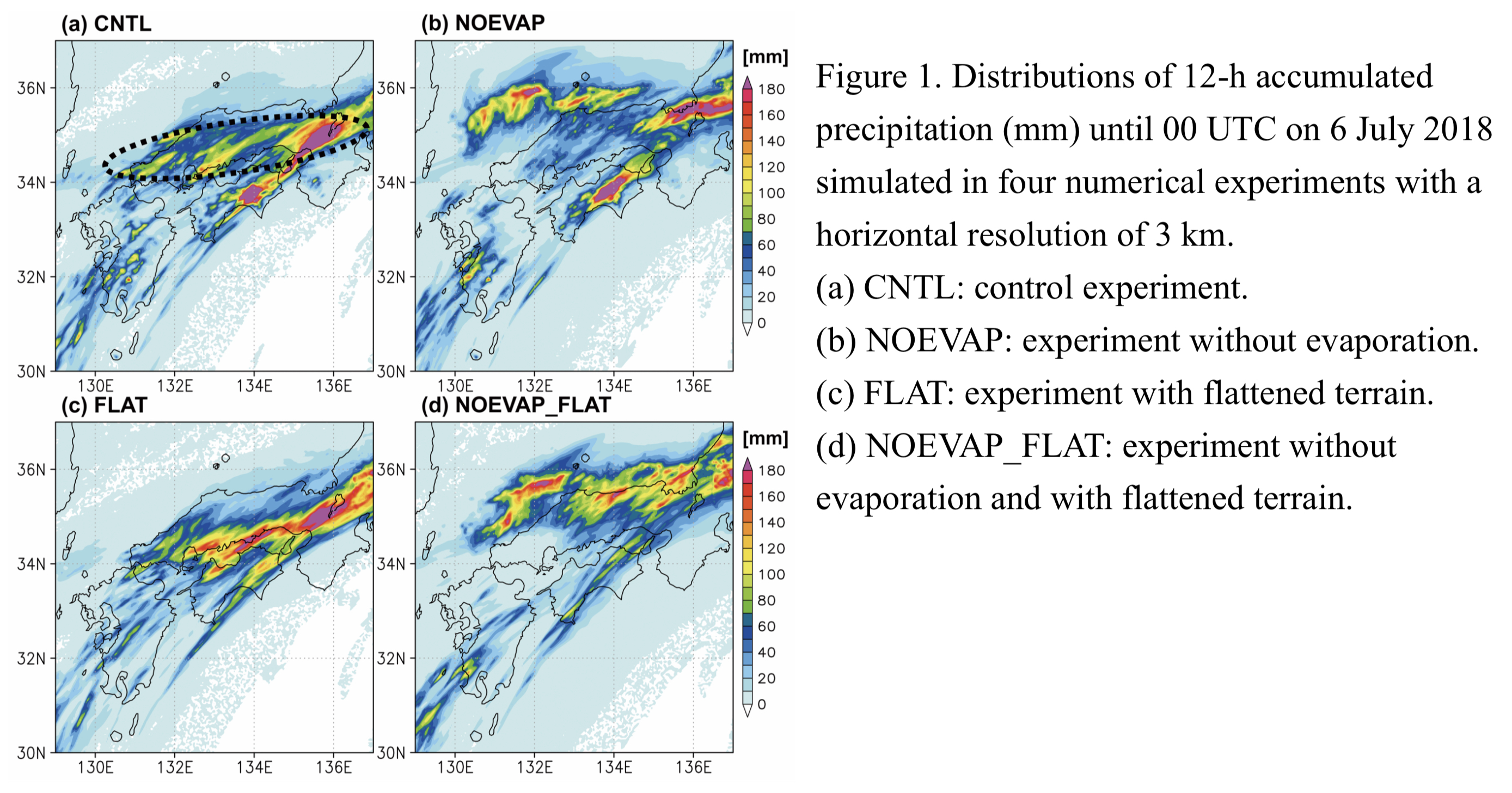
Plain Language Summary: Precipitating cloud systems during the heavy rainfall events in July of 2017 and 2018 were categorized into five types, based on the intensity, area, and lifetime of rainfall. Organized convective systems having larger rainfall areas and longer lifetimes play a major role in generating the heavy rainfalls. Column moisture content and tropospheric relative humidity characterize the environmental conditions for the occurrence of the present heavy rainfall events.
Highlights:
- This study examined rainfall contributions from five-type precipitating cloud systems, one with weaker rainfall (less than 10 mm h−1) (Type A) and four with stronger rainfall (greater than or equal to 10 mm h−1), i.e., short-live convective clusters (SLCC) (Type B), quasi-stationary convective clusters (QSCCs) (Type C), propagating convective clusters (PCCs) (Type D), and other convective but unorganized rainfall (Type E).
- The contribution from stronger rains due to organized systems with areas of 200 km2 plays a major role in regions with significant amounts of rainfall during the heavy rainfall events
- The column moisture content and the middle-to-upper-level relative humidity characterize the environmental conditions for the occurrence of the heavy rainfall events in July of 2017 and 2018.
Article: Special Edition on Global Precipitation Measurement (GPM): 5th Anniversary
Meneghini et al. (2021)
Meneghini, R., H. Kim, L. Liao, J. Kwiatkowski, and T. Iguchi, 2021: Path attenuation estimates for the GPM Dual-Frequency Precipitation Radar (DPR). J. Meteor. Soc. Japan, 99, 181-200.
Special Edition on Global Precipitation Measurement (GPM): 5th Anniversary
https://doi.org/10.2151/jmsj.2021-010
Graphical Abstract
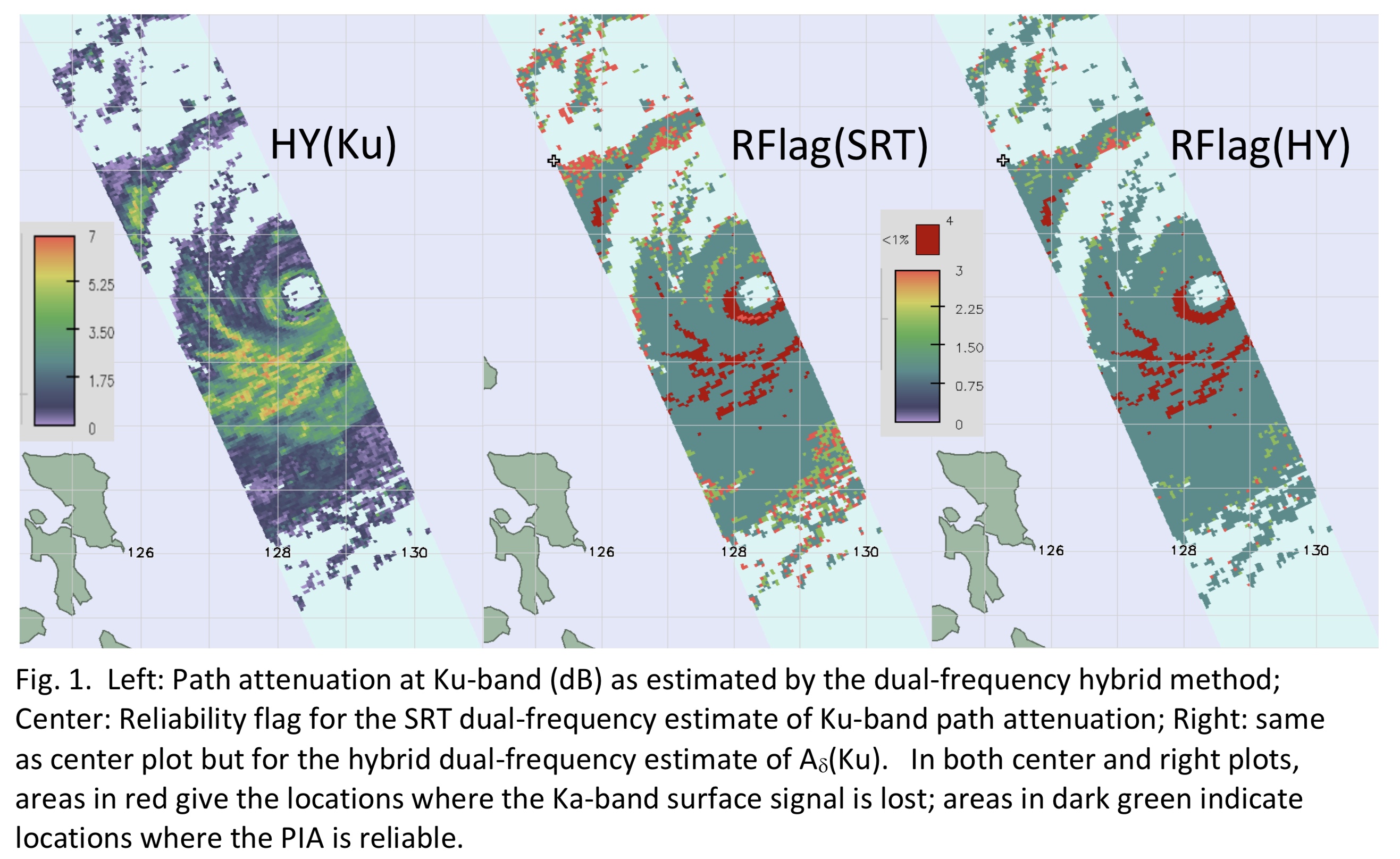
Plain Language Summary: Estimation of the path-integrated attenuation (PIA) is a critical part of retrieving precipitation parameters using measurements from the Dual-Frequency Precipitation Radar (DPR) on board the Global Precipitation Measurement Mission (GPM) satellite. In this paper, we describe and evaluate different techniques used to estimate the PIA using both single- and dual-frequency DPR radar data. The resulting algorithm forms part of the present operational system used to process the DPR data.
Highlights:
- The surface reference technique (SRT) has been applied both to the PR (TRMM) and DPR (GPM) radar data to estimate the path-integrated attenuation (PIA).
- To improve the performance of the estimate at light rain rates, the SRT has been combined with the Hitschfeld-Bordan (HB) method to produce a hybrid estimate of PIA (HY).
- A similar procedure can be used with dual-frequency estimates of PIA by combining the SRT, HB, and a traditional dual-frequency PIA estimate (DW) to produce a dual-frequency hybrid estimate, an example of which is shown in the left-hand panel of the above figure.
- Although the dual-frequency estimate of PIA is generally more accurate than the single- frequency estimate, a shortcoming is that, in areas of high rain rate, the Ka-band surface signal is often lost. Examples of this are shown by the red areas in the center and right panels above.
- In these cases, the single-frequency Ku-band data are used to estimate the path attenuation at Ku-band.
JMSJ, 2021, Vol. 99, No. 2 (April)
Article: Special Edition on Global Precipitation Measurement (GPM): 5th Anniversary
Seto et al. (2021)
Seto, S., T. Iguchi, R. Meneghini, J. Awaka, T. Kubota, T. Masaki, and N. Takahashi, 2021: The Precipitation rate retrieval algorithms for the GPM Dual-frequency Precipitation Radar. J. Meteor. Soc. Japan, 99, 205-237.
Special Edition on Global Precipitation Measurement (GPM): 5th Anniversary
https://doi.org/10.2151/jmsj.2021-011
Graphical Abstract
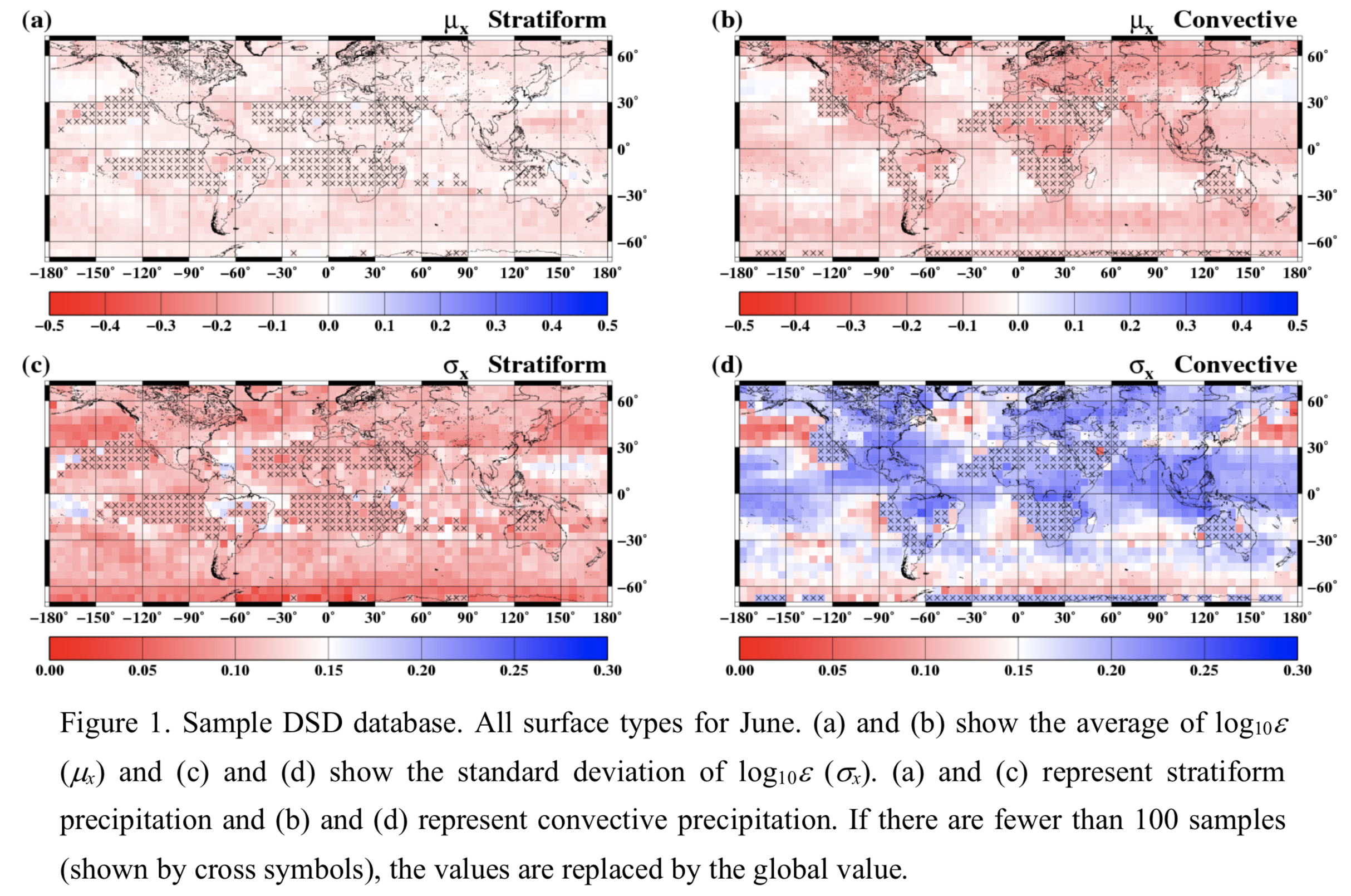
Plain Language Summary: New precipitation rate retrieval algorithms (version 06A) for the GPM Dual-frequency Precipitation Radar are developed. Major changes from the previous algorithms (version 03B) include the introduction of the relation between precipitation rate and mass-weighted mean diameter (R−Dm relation), non-uniform beam filling correction, DSD database (single-frequency algorithms only), and the ZfKa method (dual-frequency algorithm only).
Highlights:
- The R−Dm relation is used instead of the k−Ze relation for KuPR algorithm and also for the KaPR algorithm and the dual-frequency algorithm, meaning that the three algorithms share a common constraint on the DSD.
- The DSD database includes the statistics of the adjustment factor for the R−Dm relation (ε) and has been introduced to convert information obtained from the dual-frequency algorithm for application to the single-frequency algorithms.
- The dual-frequency algorithm has the advantages that it can select KuPR or KaPR for the precipitation echoes and use additional evaluation criteria such as the ZfKa method and Dual-frequency Surface Reference Technique (DSRT). For more than 90% of the precipitation pixels, either the ZfKa method or DSRT is used.
Review Article
Hitchman et al. (2021)
Hitchman, M. H., S. Yoden, P. H. Haynes, V. Kumar, and S. Tegtmeier, 2021: An observational history of the direct influence of the stratospheric Quasi-biennial Oscillation on the tropical and subtropical upper troposphere and lower stratosphere. J. Meteor. Soc. Japan, 99, 239-267.
https://doi.org/10.2151/jmsj.2021-012
Graphical Abstract
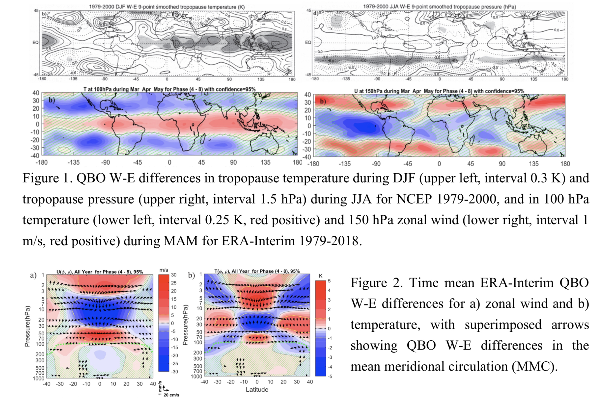
Plain Language Summary: The history of observational studies regarding the influence of the quasi-biennial oscillation (QBO) on the tropical and subtropical upper troposphere and lower stratosphere (UTLS) is described. The seasonal and geographical variation of QBO westerly (W) minus easterly (E) differences in UTLS temperature, pressure, and zonal wind is presented. Results from the periods 1958-1978 and 1978-2000 using National Centers for Environmental Prediction (NCEP) reanalyses are compared with modern updates using Modern-Era Retrospective analysis for Research and Applications, Version 2 (MERRA2) data for 1980-2017, and European Centre for Medium Range Weather Forecasting Reanalysis – Interim (ERA-Interim) data for 1979-2018.
Highlights:
- QBO W in lower stratosphere favors warmer tropical UTLS and colder subtropical UTLS
- Agreement among data sets, with larger temperature signal near seasonal convective centers
- Subtropical signal enhanced during MAM in both hemispheres, JJA in SH, and DJF in NH
- Subtropical westerly jets enhanced during QBO W, especially during MAM
- Annual and seasonal depictions of QBO structure in temperature, zonal wind, and MMC
Article: Special Edition on Global Precipitation Measurement (GPM): 5th Anniversary
Jian et al. (2021)
Jian, H.-W., W.-T. Chen, P.-J. Chen, C.-M. Wu, and K. I. Rasmussen, 2021: The synoptically- influenced extreme precipitation systems over Asian-Australian monsoon region observed by TRMM Precipitation Radar. J. Meteor. Soc. Japan, 99, 269-285.
Special Edition on Global Precipitation Measurement (GPM): 5th Anniversary
https://doi.org/10.2151/jmsj.2021-013
Graphical Abstract
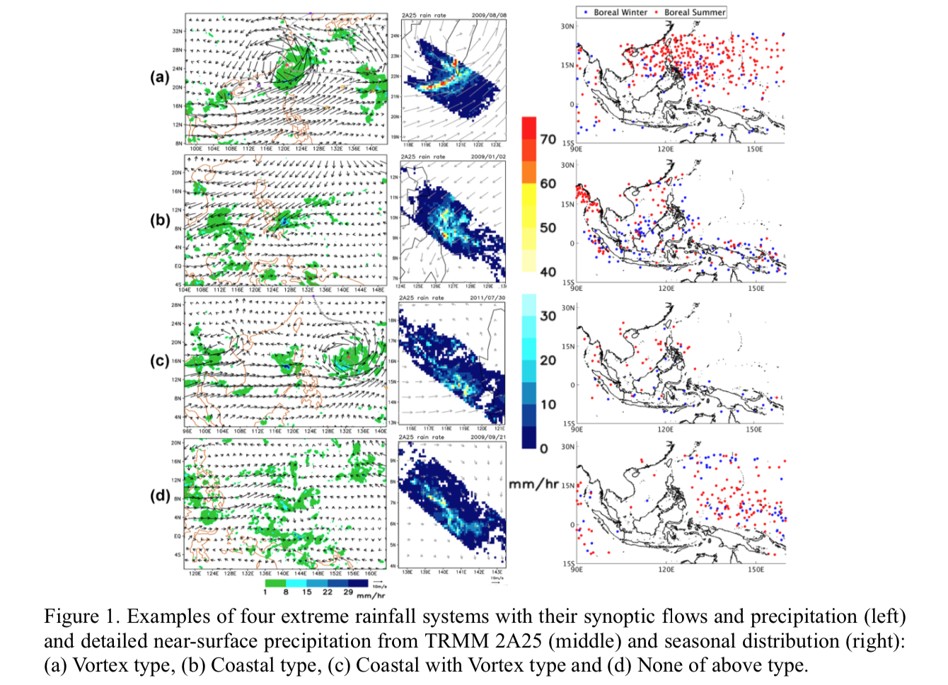
Plain Language Summary: This study investigates the synoptic-scale flows associated with extreme rainfall systems over the Asian-Australian monsoon region observed by precipitation radar onboard TRMM satellite. The extreme rainfall systems are classified into four categories based on the synoptic flow patterns and the vicinity to coastlines. The spatial-temporal variation of the four categories and their internal structures are examined.
Highlights:
- Areas with high total column water vapor and low-level vertical wind shear are consistent with the hotspots of Coastal and Coastal with Vortex types of extreme precipitation systems.
- Despite the different synoptic environments, these extremes show a similar internal structure, with broad stratiform and wide convective core rain.
- The maximum rain rate in the extreme systems occurs at the boundary of convective and stratiform regions.
Article
Yamashita et al. (2021)
Yamashita, Y., M. Takigawa, D. Goto, H. Yashiro, M. Satoh, Y. Kanaya, F. Taketani, and T. Miyakawa, 2021: Effect of model resolution on black Carbon transport from Siberia to the Arctic associated with the well-developed low-pressure systems in September. J. Meteor. Soc. Japan, 99, 287-308.
https://doi.org/10.2151/jmsj.2021-014
Graphical Abstract
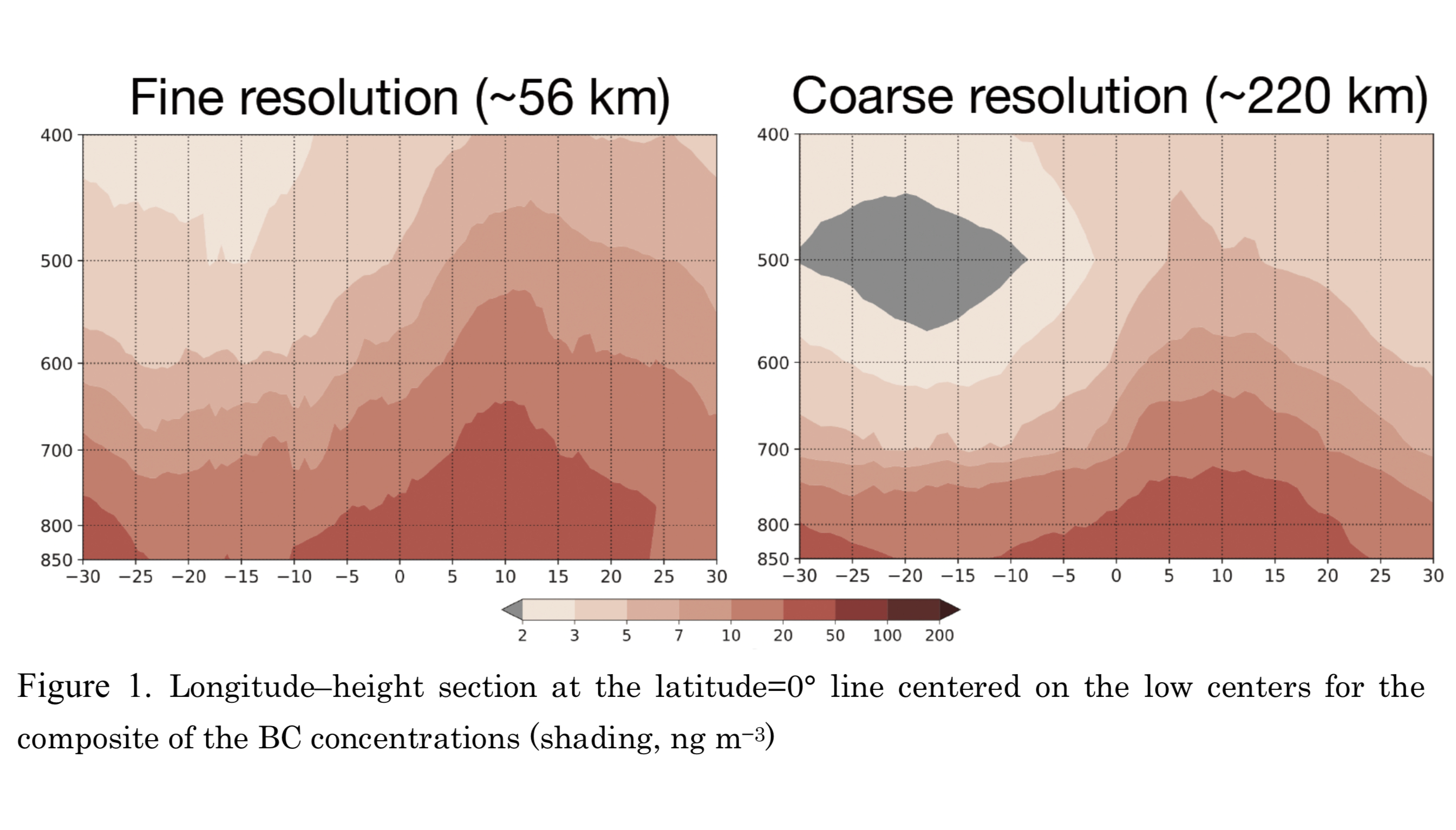
Plain Language Summary: Atmospheric transport of black carbon (BC) affects the absorption/scattering of solar radiation, precipitation, and snow/ice cover, especially in areas of low human activity such as the Arctic. The resolution dependency of simulated BC transport from Siberia to the Arctic, related to the well-developed low-pressure systems in September, was evaluated using the Nonhydrostatic Icosahedral Atmospheric Model–Spectral Radiation Transport Model for Aerosol Species (NICAM-SPRINTARS) with fine (∼ 56 km) and coarse (∼ 220 km) horizontal resolutions.
Highlights:
- The transport of the BC to the Arctic is evaluated with the composite analysis for the developed low-pressure events in September from 2015–2018.
- The high-BC area is located eastwards of the low’s center in relation to the ascending motion over the low’s center and northward/eastward area.
- This study indicates that the material transport processes to the Arctic by the well-developed low-pressure systems are enhanced in the fine horizontal resolution (~56 km) relative to the coarse horizontal resolution (~220 km) models, since the area of the maximum ascending motion has a small horizontal scale.
- This implies that the fine horizontal resolution (~56 km) will be desirable for the precise treatment of transport processes in the future chemistry transport models.
Article
Chandra et al. (2021)
Chandra, N., P. K. Patra, J. S. H. Bisht, A. Ito, T. Umezawa, N. Saigusa, S. Morimoto, S. Aoki, G. Janssens-Menhout, and R. Fujita, M. Takigawa, S. Watanabe, N. Saitoh, and J. G. Canadell, 2021: Emissions from the oil and gas sectors, coal mining and ruminant farming drive methane growth over the past three decades. J. Meteor. Soc. Japan, 99, 309-337.
https://doi.org/10.2151/jmsj.2021-015
Graphical Abstract
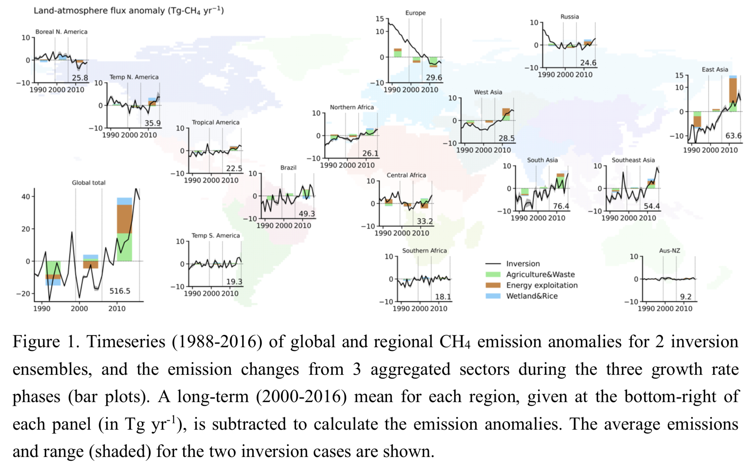
Plain Language Summary: Methane (CH4) is an important greenhouse gas and plays a significant role in tropospheric and stratospheric chemistry. CH4 growth rate (i.e., year to year change) in atmosphere varied in three distinct phases in the past three decades (1988-2016); namely, the periods of slowed (1988-1998), quasi-stationary (1999-2006) and renewed (2007-2016) growth phases. These distinct growth rate phases are explained by the anomalies in global and regional emissions that are estimated with an atmospheric chemistry-transport model (ACTM) based inverse modelling framework and observations from 19 sites worldwide. The anomalies in global and regional emissions are further attributed into different sectorial categories with the help of emission inventory.
Highlights:
- We proposed that CH4 growth anomalies can be explained mainly by the changes in anthropogenic emissions, from the oil and gas exploitation, coal mining and livestock farming.
- The natural phenomena, such as the Mt. Pinatubo eruption and more frequent El Niño in the 1990s, have also helped to slow down the growth and achieve the quasi-stationary growth rate.
- Estimated CH4 emission anomalies are evaluated against independent aircraft observations, 13C-CH4 isotopic signature, and other inventory/inverse modelling results.
Article
Takemura et al. (2021)
Takemura, K., T. Enomoto, and H. Mukougawa, 2021: Predictability of enhanced monsoon trough related to the meandered Asian jet and consequent Rossby wave breaking in late August 2016. J. Meteor. Soc. Japan, 99, 339-356.
https://doi.org/10.2151/jmsj.2021-016
Graphical Abstract
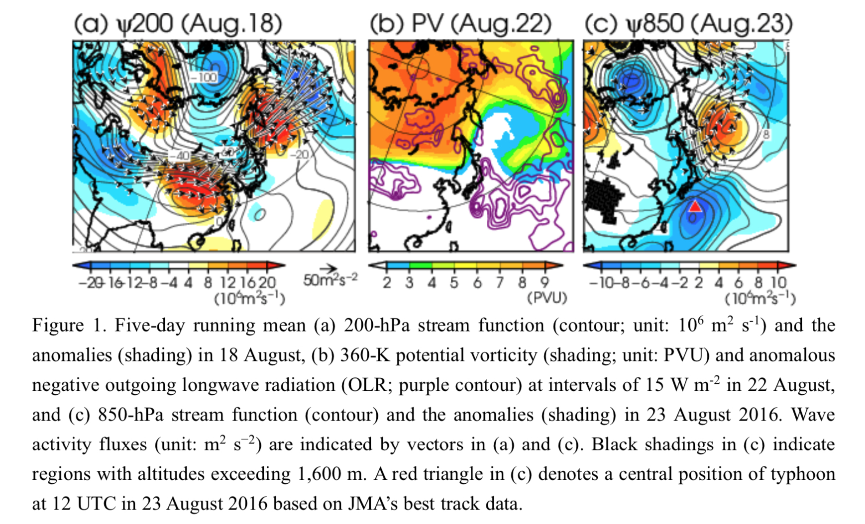
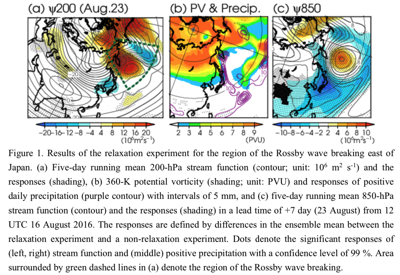
Plain Language Summary: Predictability of an enhanced monsoon trough south of Japan seen in late August 2016 is diagnosed. The monsoon trough is found to be enhanced by a meandering of the Asian jet and by a subsequent Rossby wave breaking east of Japan (Fig. 1). Japan Meteorological Agency (JMA)’s operational one-month ensemble forecast from 12 UTC 16 August 2016 fails to predict the enhanced monsoon trough. The main findings obtained from the predictability assessment are summarized as follows.
Highlights:
- A simple sensitivity analysis based on ensemble singular vectors indicates that initial perturbations over the Bering sea and near the Asian jet entrance region can efficiently grow and propagate toward the region to the south of Japan, affecting the predictability of the enhanced monsoon trough.
- The monsoon trough in perturbed hindcast experiments with the initial perturbations obtained from the simple sensitivity analysis is significantly enhanced compared with that in an unperturbed one, supporting the simple sensitivity analysis.
Article
Chandra et al. (2021)
Chandra, N., P. K. Patra, J. S. H. Bisht, A. Ito, T. Umezawa, N. Saigusa, S. Morimoto, S. Aoki, G. Janssens-Menhout, and R. Fujita, M. Takigawa, S. Watanabe, N. Saitoh, and J. G. Canadell, 2021: Emissions from the oil and gas sectors, coal mining and ruminant farming drive methane growth over the past three decades. J. Meteor. Soc. Japan, 99, 357-377.
https://doi.org/10.2151/jmsj.2021-017
Graphical Abstract
Plain Language Summary: Methane (CH4) is an important greenhouse gas and plays a significant role in tropospheric and stratospheric chemistry. CH4 growth rate (i.e., year to year change) in atmosphere varied in three distinct phases in the past three decades (1988-2016); namely, the periods of slowed (1988-1998), quasi-stationary (1999-2006) and renewed (2007-2016) growth phases. These distinct growth rate phases are explained by the anomalies in global and regional emissions that are estimated with an atmospheric chemistry-transport model (ACTM) based inverse modelling framework and observations from 19 sites worldwide. The anomalies in global and regional emissions are further attributed into different sectorial categories with the help of emission inventory.
Highlights:
- We proposed that CH4 growth anomalies can be explained mainly by the changes in anthropogenic emissions, from the oil and gas exploitation, coal mining and livestock farming.
- The natural phenomena, such as the Mt. Pinatubo eruption and more frequent El Niño in the 1990s, have also helped to slow down the growth and achieve the quasi-stationary growth rate.
- Estimated CH4 emission anomalies are evaluated against independent aircraft observations, 13C-CH4 isotopic signature, and other inventory/inverse modelling results.
Article: Special Edition on Global Precipitation Measurement (GPM): 5th Anniversary
Seiki (2021)
Seiki, T., 2021: Near-global three-dimensional hail signals detected by using GPM-DPR observations. J. Meteor. Soc. Japan, 99, 379-402.
Special Edition on Global Precipitation Measurement (GPM): 5th Anniversary
https://doi.org/10.2151/jmsj.2021-018
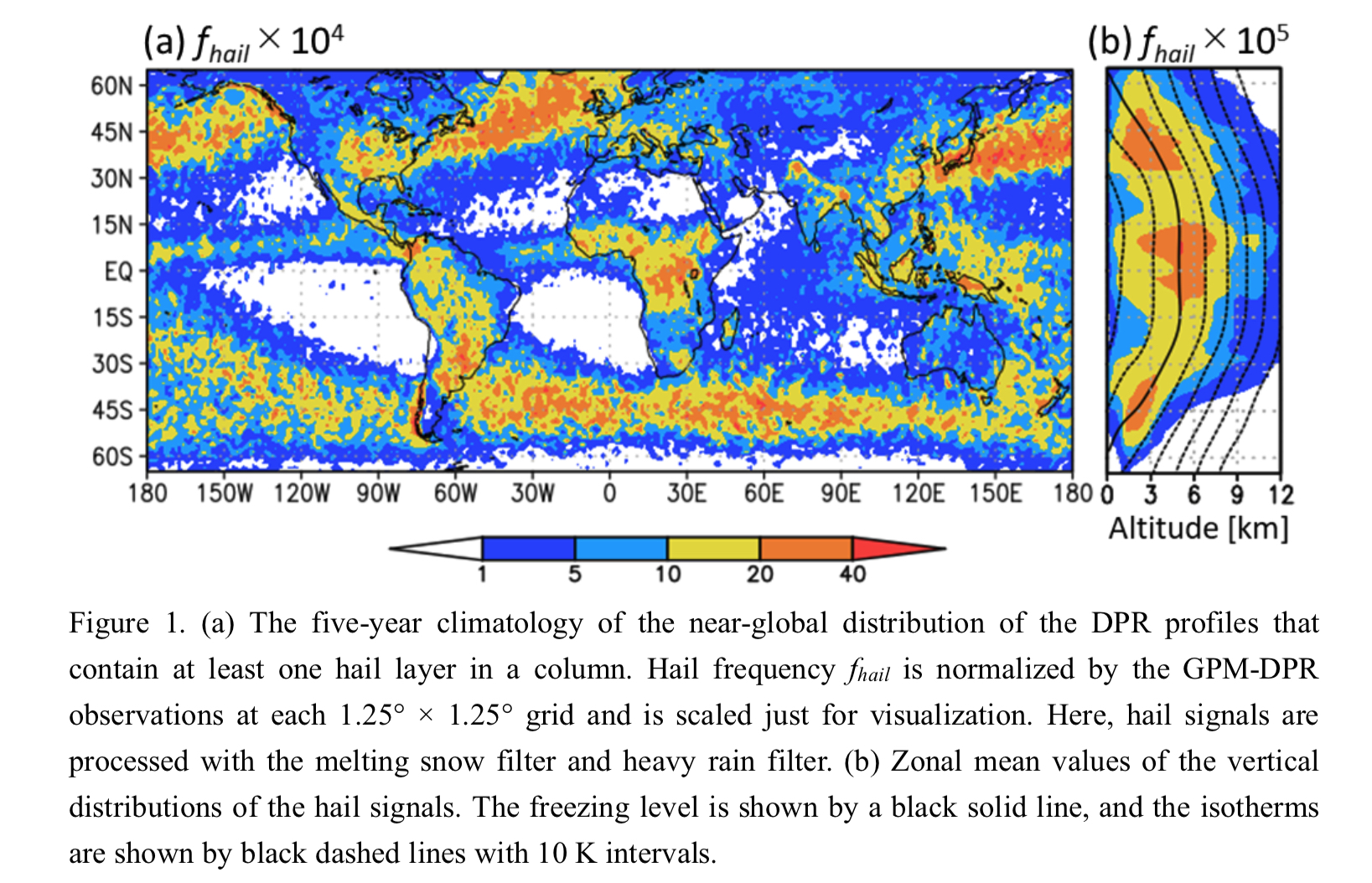
Graphical Abstract
Plain Language Summary: Hail is a large dense ice particle and its particle size often reaches more than 1 cm. Hail is known to be associated with intense storms and causes severe damage to cars, buildings, and croplands. In general, hail has been observed by weather radar systems or reported from visual check on the ground. Such the observations are limited to developed countries and populated regions and, hence, global three-dimensional structure of hail has not been analyzed yet. This study proposed a method to detect hail signals using space-borne radar observations and successfully illustrated a near-global three-dimensional hail map. This new dataset for hail is to be utilized for improving weather forecasting and risk management of hail disasters in the global scale.
Highlights:
- Near-global three-dimensional distribution of hail is obtained by using a dual-frequency precipitation radar.
- Hail signals lie along collisional growth curves on the scatter diagram of the radar reflectivity factors.
- Hail is widely distributed over the ocean and is frequently observed near the freezing level.
Article
Shibata and Sai (2021)
Shibata, K., and A. Sai, 2021: Long-term trends and variations in surface humidity and temperature in the Japanese archipelago over 100 years from 1880s. J. Meteor. Soc. Japan, 99, 403-422.
https://doi.org/10.2151/jmsj.2021-019
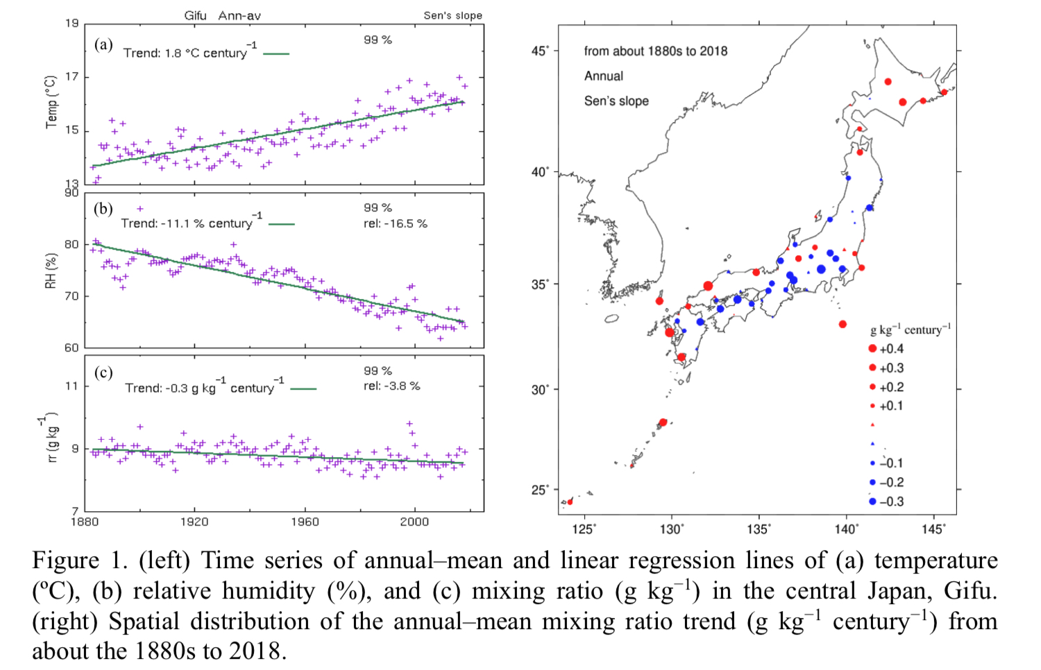
Graphical Abstract
Plain Language Summary: The surface observation data in Japan, beginning around the 1880s, are analyzed focusing on the long–term trends and variations in humidity and temperature. It is found that the annual–mean temperature trend exhibits statistically significant warming of 1.0°C–2.5°C century-1, while the annual–mean relative humidity shows significantly decreasing trend of −2% to −12% century-1. On the other hand, the annual–mean mixing ratio trend displays a different spatial distribution compared to the temperature or relative humidity trend. In this study, three types of trends exist: significantly positive and negative values, and virtually zero. Significantly negative trends of about −0.2 to −0.3 g kg-1 century-1 are located approximately in the Pacific side of Honshu from the middle Tohoku through Shikoku to the eastern Kyushu. Significantly positive trends of about 0.2 to 0.4 g kg-1 century-1 are observed over Hokkaido, the western Japan along Sea of Japan, the western Kyushu, and the remote islands including Okinawa.
Highlights:
- Empirical orthogonal function (EOF) analysis indicates that the linear trends in the annual–mean temperature and relative humidity can be almost explained by the nearly uniform persistent warming and drying of EOF–1 components.
- For the annual–mean mixing ratio, EOF–2 is almost identical with the linear trend component, although the fraction of EOF–2 (14%) is much smaller than that of EOF–1 (49%).
- In recent years from 1960 to 2018 the mixing ratio and temperature trends are very different from those in the longer period from the 1880s. The mixing ratio trend and the temperature trend increase on average from 0.0 to 0.5 g kg-1 century-1 and from 1.5°C to 2.5°C century-1, respectively.
Article: Special Edition on Global Precipitation Measurement (GPM): 5th Anniversary
De Meyer and Roca (2021)
De Meyer, V., and R. Roca, 2021: Thermodynamic scaling of extreme daily precipitation over the tropical ocean from satellite observations. J. Meteor. Soc. Japan, 99, 423-436.
Special Edition on Global Precipitation Measurement (GPM): 5th Anniversary
https://doi.org/10.2151/jmsj.2021-020
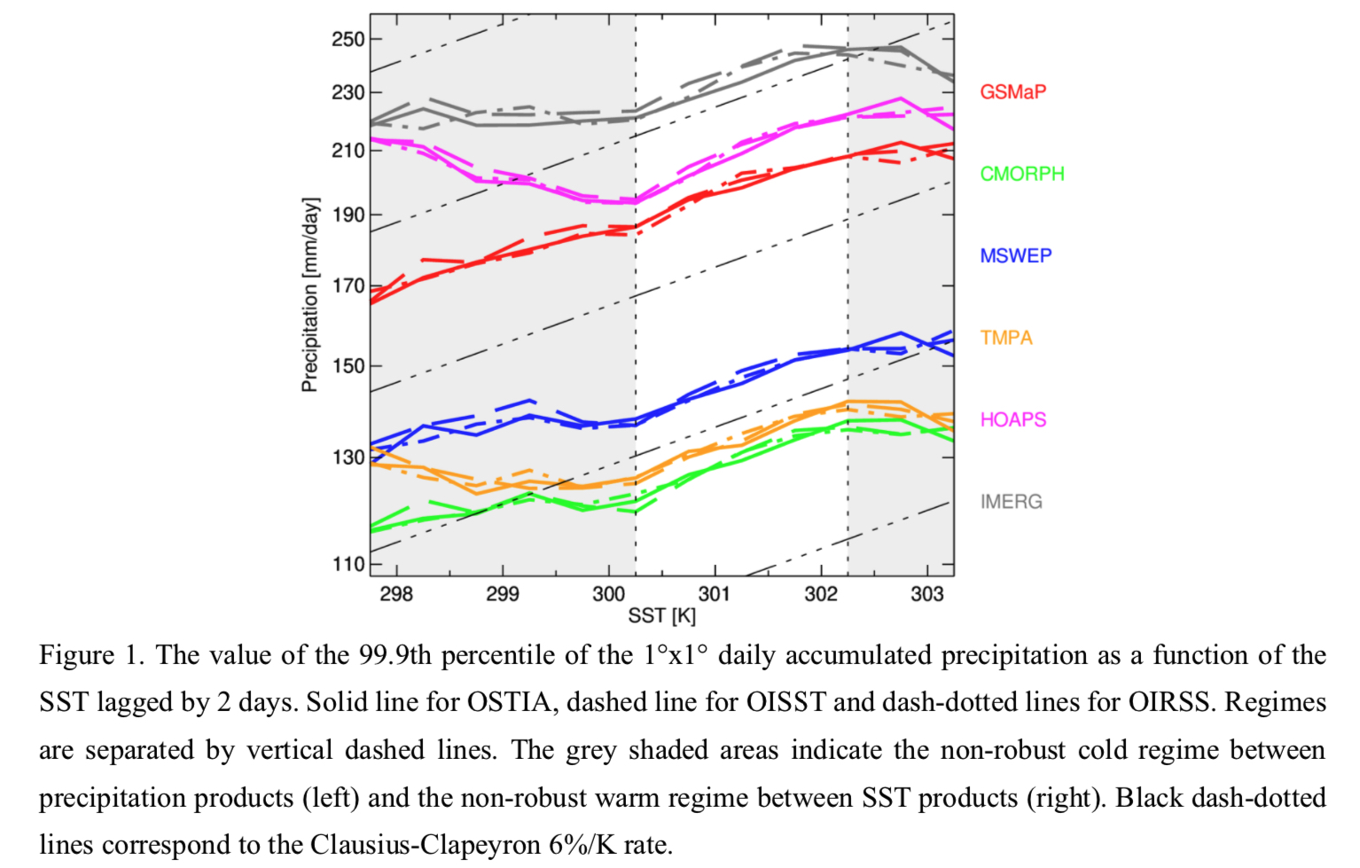
Graphical Abstract
Plain Language Summary: Extreme precipitation is expected to increase in a warmer climate at the same rate of the surface humidity, that is the Clausius-Clapeyron rate (~6%/K in the tropics). This study investigates the scaling of the extreme precipitation over the tropical ocean using an ensemble of satellite-based precipitation products and SST analysis. The microwave constellation-based products show a very robust positive scaling range between 300K to 302.5K, with an ensemble mean very close to the 6%/K theoretical expectation.
Highlights:
- The extreme precipitation theory is confirmed using 1°-1day resolution satellite-based precipitation and SST products within a specific SST temperature range.
- The analysis conducted with a 5-, 11- and 17-years long period and with 3 different SST products shows no major discrepancies, as long as the SST is lagged by 2 days prior to the precipitation event.
- The robustness of the results confirms the fitness of the current generation of constellation-based precipitation products for extreme precipitation analysis.
Article
Jain et al. (2021)
Jain, S., R. Chhin, R. M. Doherty, S. K. Mishra, and S. Yoden, 2021: A new graphical method to diagnose the impacts of model changes on climate sensitivity. J. Meteor. Soc. Japan, 99, 437-448.
https://doi.org/10.2151/jmsj.2021-021
Graphical Abstract
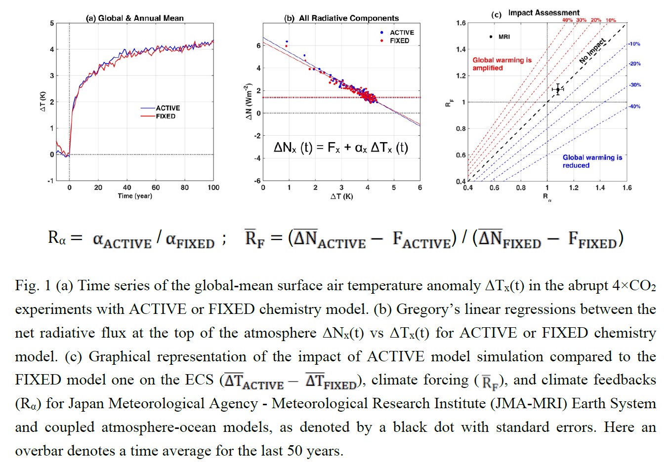
Plain Language Summary: Equilibrium climate sensitivity (ECS) is defined as the change in global-mean surface air temperature (ΔT) due to the quadrupling of CO2 in a climate model simulation (Fig.1a). In this paper, we propose a new graphical method, which is based on Gregory’s linear regressions (Fig.1b), to visualize the impact of a model change on ECS, climate forcing (RF), and feedbacks (Rα) in a single diagram (Fig.1c), and demonstrate its usefulness with an example of climate sensitivity simulations with interactive (ACTIVE) and prescribed (FIXED) chemistry model.
Highlights:
- Using this visualization method, one can quantify (a) whether the model-change amplifies, or reduces the global warming, and evaluate (b) the percentage changes in ECS (ΔT), climate forcing (RF), and climate feedbacks (Rα), and (c) ranges of the uncertainties in the estimated changes.
- This method can also be used to examine the spread in ECS, climate forcing, and climate feedbacks with respect to the multi-model mean (or one benchmark model) for multi-model frameworks like Coupled Model Intercomparison Project Phase 5/6 (CMIP5/6).
Notes and Correspondence
Maeda et al. (2021)
Maeda, S., K. Takemura and C. Kobayashi, 2021: Planetary wave modulations associated with the Eurasian teleconnection pattern. J. Meteor. Soc. Japan, 99, 449-458.
https://doi.org/10.2151/jmsj.2021-022
Graphical Abstract
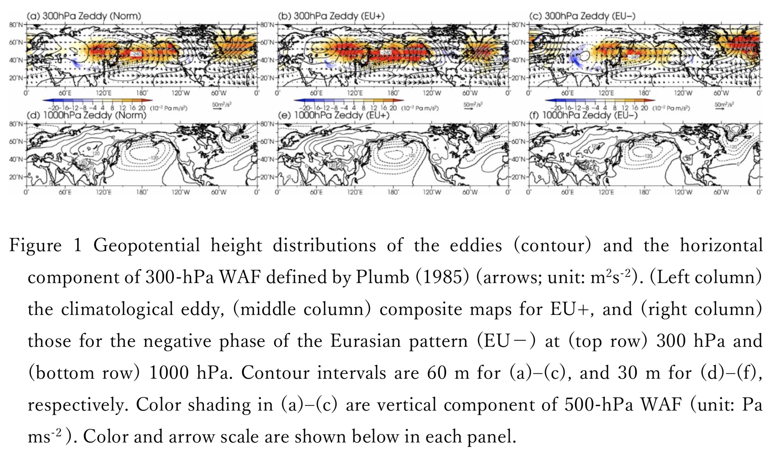
Plain Language Summary: This study analyzes the modulation of planetary waves associated with the Eurasian pattern through composite analyses to reveal its dynamic mechanism, including wave-mean flow interaction. In the positive phase of the Eurasian pattern (EU+), corresponding to the enhanced Asian monsoon, the upward and eastward propagation of the planetary wave from the Central Eurasia to the North Pacific in the troposphere is enhanced. The enhanced upward and eastward propagating planetary wave converges in the upper troposphere, thereby causing anomalous extratropical direct circulation and cold outflow toward the mid-latitude lower troposphere.
Highlights:
- In the EU+, the upward and eastward propagation of the planetary wave from the Central Eurasia to the North Pacific in the troposphere is enhanced.
- The baroclinic energy conversion from the zonal mean to the deviation from that over East Asia contributes to the amplified planetary wave.
- The enhanced upward and eastward propagating planetary wave converges in the upper troposphere, thereby causing anomalous extratropical direct circulation.
Article
Takemura and Mukougawa (2021)
Takemura, K., and H. Mukougawa, 2021: Relaxation experiments for predictability assessment of enhanced monsoon trough in late August 2016. J. Meteor. Soc. Japan, 99, 459-472.
https://doi.org/10.2151/jmsj.2021-023
Graphical Abstract
Plain Language Summary: Predictability of an enhanced monsoon trough south of Japan seen in late August 2016 is diagnosed using an atmospheric general circulation model. The trough is found to be enhanced by a Rossby wave propagation over Eurasia and the subsequent Rossby wave breaking east of Japan. Three types of relaxation experiments are conducted, with nudging the model forecast toward reanalysis, for regions of the Rossby wave breaking, Rossby wave propagation, and both the regions. The main findings obtained from the experiments are summarized as follows.
Highlights:
- Compared to a non-relaxation experiment, the relaxation experiments show enhancements of the Rossby wave propagation and Rossby wave breaking, as seen in the reanalysis. The upper-level wave amplification contributes to the improved reproducibility of the enhanced monsoon trough, through the well reproduced southwestward intrusion of upper-level high potential vorticity airmass.
- The relaxation experiments show that the Rossby wave breaking plays a primary role in predicting the monsoon trough, while the Rossby wave propagation plays a secondary role.
Article: Special Edition on Global Precipitation Measurement (GPM): 5th Anniversary
Sawada and Ueno (2021)
Sawada, M., and K. Ueno, 2021: Heavy winter precipitation events with extratropical cyclone diagnosed by GPM products and trajectory analysis. J. Meteor. Soc. Japan, 99, 473-496.
Special Edition on Global Precipitation Measurement (GPM): 5th Anniversary
https://doi.org/10.2151/jmsj.2021-024
Graphical Abstract
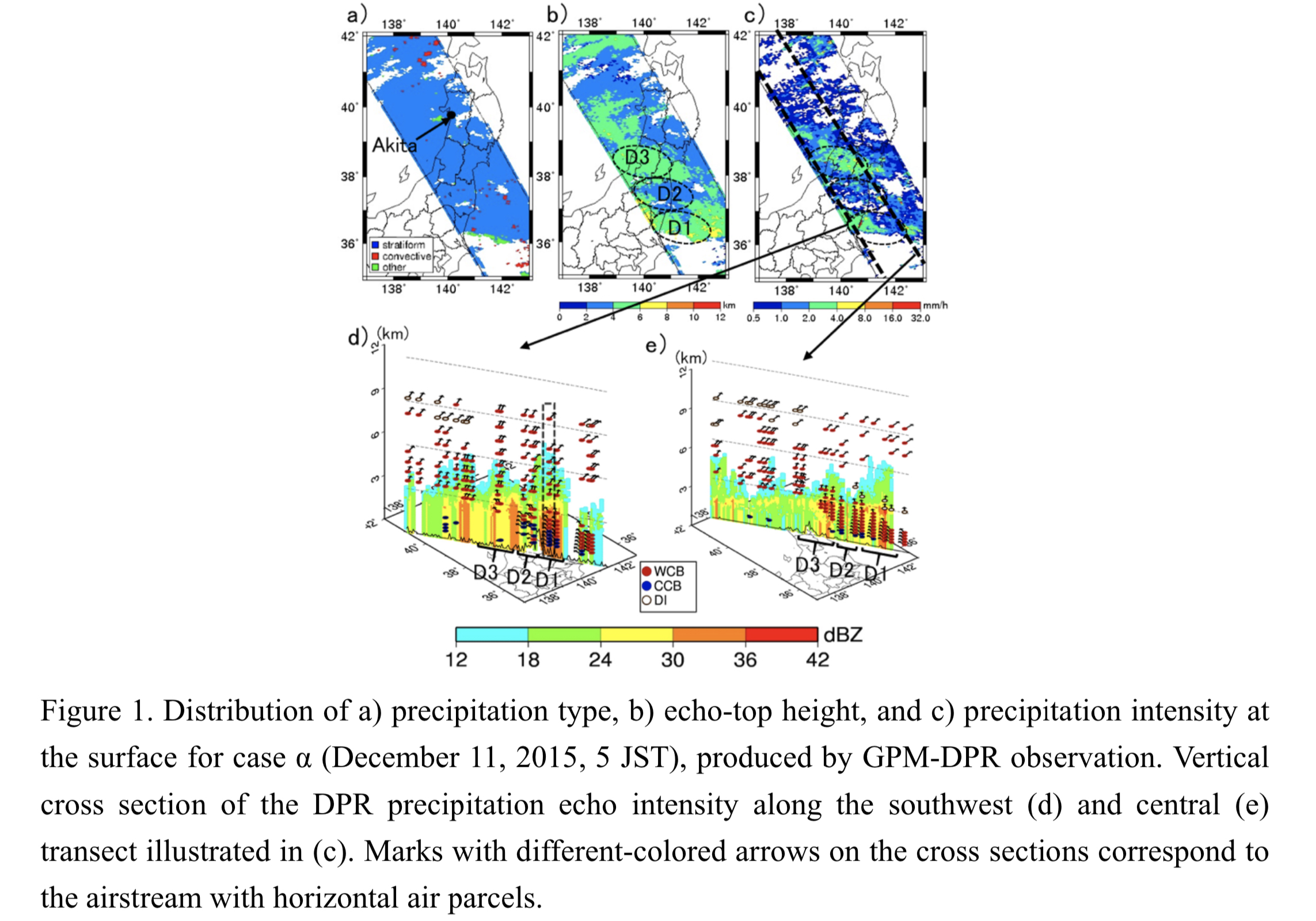
Plain Language Summary: The mechanisms for producing heavy precipitation regarding the structure of an occluding extratropical cyclone during the cold seasons were analyzed using the products of the Dual-frequency Precipitation Radar (DPR) onboard the Global Precipitation Measurement (GPM) core satellite and trajectory analysis on the European Centre for Medium-range Weather Forecasts atmospheric reanalysis data.
Highlights:
- Hourly precipitation changes at stations that recorded heavy precipitation were primarily affected by a combination of the warm conveyor belt (WCB), cold conveyor belt (CCB), and dry intrusion (DI).
- Wide-ranging stratiform precipitation east of the cyclone center was composed of low-level WCB over the CCB and upper WCB, and convective clouds around the cyclone center were associated with the upper DI over the WCB that provided an extreme precipitation rate at the surface.
- DPR products also identified deep stratiform precipitation in the cloud-head area behind the cyclone center with mid-level (near-surface) latent heat release (absorption) with increased potential vorticity along the CCB, making feedback intensification of the cyclone possible.
Article
Voelger and Dalin (2021)
Voelger, P and P. Dalin, 2021: A case study of a quasi-stationary, very long polar stratospheric cloud layer edge. J. Meteor. Soc. Japan, 98, 497-504.
https://doi.org/10.2151/jmsj.2021-025
Graphical Abstract
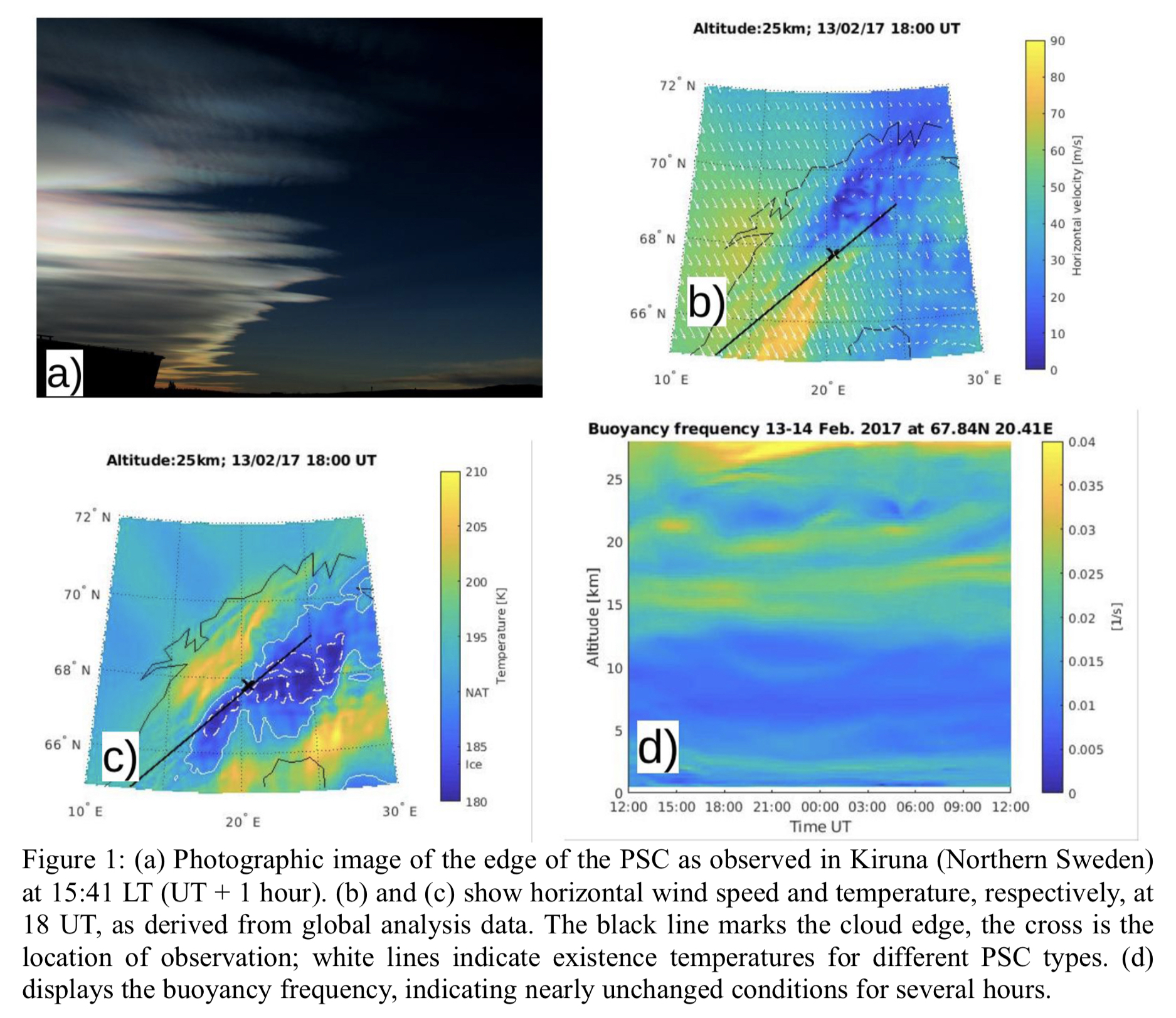
Plain Language Summary: A very long (more 600 km) straight edge of a Polar Stratospheric Cloud (PSC), located at 24-26 km altitude, was observed east of the Scandinavian Mountain Range both by an optical camera and by lidar. The cloud edge remained unchanged for several hours. We investigated the atmospheric conditions during observation which led to the unusual feature.
Highlights:
- We found that, during the period of observation, strong homogeneous winds were blowing across the mountain range. This triggered the formation of lee waves behind the mountains. The waves propagated from the lower troposphere up to the stratosphere where they resulted in a temperature modulation that caused the long cloud edge to form along the mountain range.
- For the observed quasi-stationary cloud edge a standing wave is required which needs horizontal winds with 40 m/s wind speed. Such wind speeds were present in the lower troposphere at about 3 km altitude.
Article: Special Edition on Years of the Maritime Continent (YMC)
Feng et al. (2021)
Feng, L., T. Zhang, T.-Y. Koh, and E. M. Hill, 2021: Selected years of monsoon variations and extratropical dry-air intrusions compared with the Sumatran GPS array observations in Indonesia. J. Meteor. Soc. Japan, 99, 505-536.
Special Edition on Years of the Maritime Continent (YMC)
https://doi.org/10.2151/jmsj.2021-026
Graphical Abstract
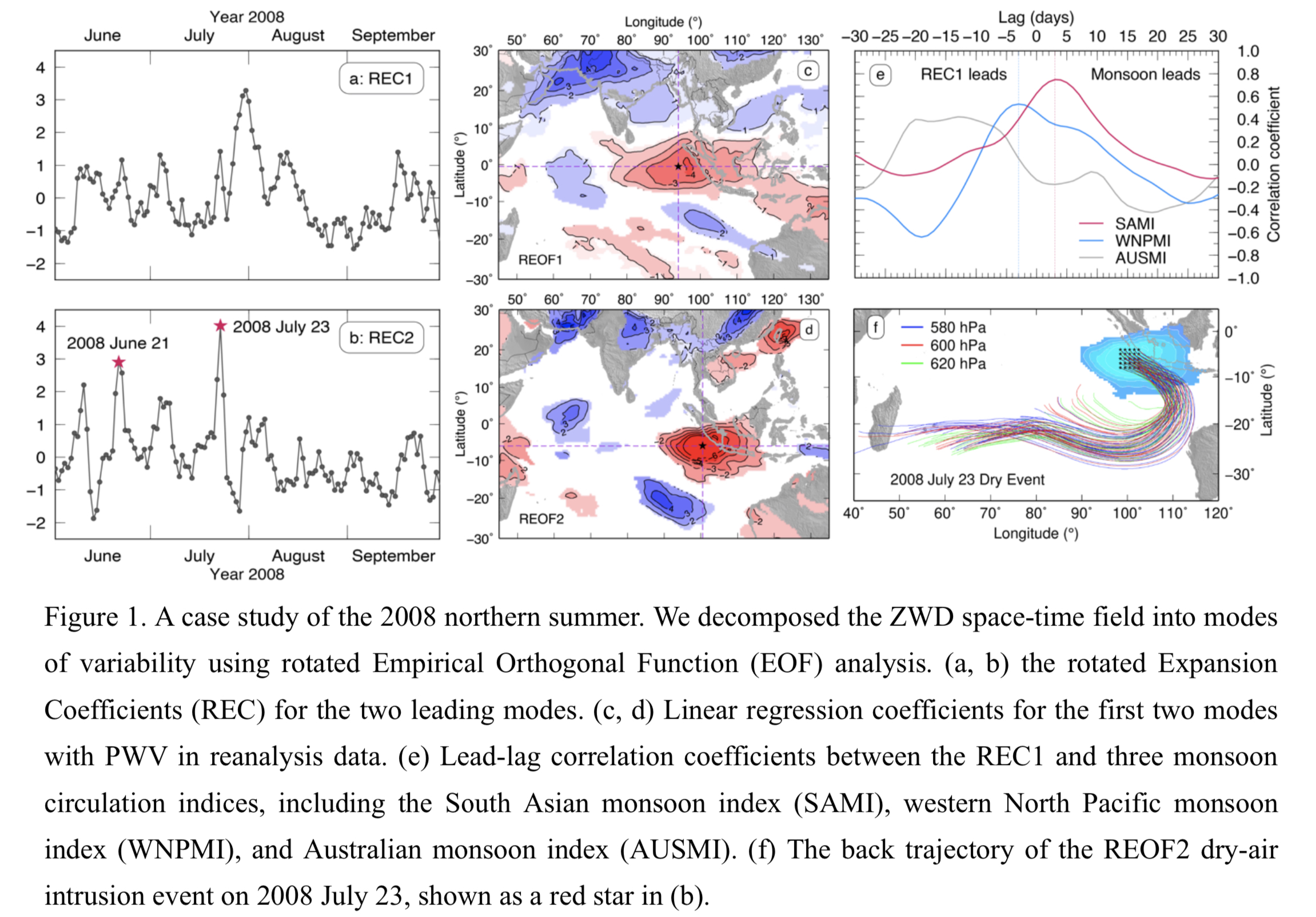
Plain Language Summary: Although the Global Positioning System (GPS) has been widely used to study long-term trends or diurnal and subdiurnal cycles of precipitable water vapor (PWV), it has been rarely used for the intra-seasonal scale. We used the zenith wet delay (ZWD) data from the Sumatran GPS Array (SuGAr) in Indonesia, with help from reanalysis data, to study the summer intra-seasonal variability of PWV over Sumatra in years without strong inter-annual variability, and to probe the underlying atmospheric processes that control the variability.
Highlights:
- The summer intra-seasonal variability of daily ZWD over Sumatra in 2008, 2016, and 2017 is dominated by the South Asian Summer Monsoon, and further influenced by dry-air intrusions associated with eastward-propagating Rossby waves in the Southern Hemisphere midlatitudes.
- As the first ground-based GPS data used for studying dry-air intrusions, the SuGAr data provide new in-situ evidence that extratropical dry-air intrusions reach the deep tropics within 5° south of the equator over the Maritime Continent.
Article
Li and Wang (2021)
Li, T.-H., and Y. Wang, 2021: The role of boundary layer dynamics in tropical cyclone intensification. Part I: Sensitivity to surface drag coefficient. J. Meteor. Soc. Japan, 99, 537-554.
https://doi.org/10.2151/jmsj.2021-027
Graphical Abstract
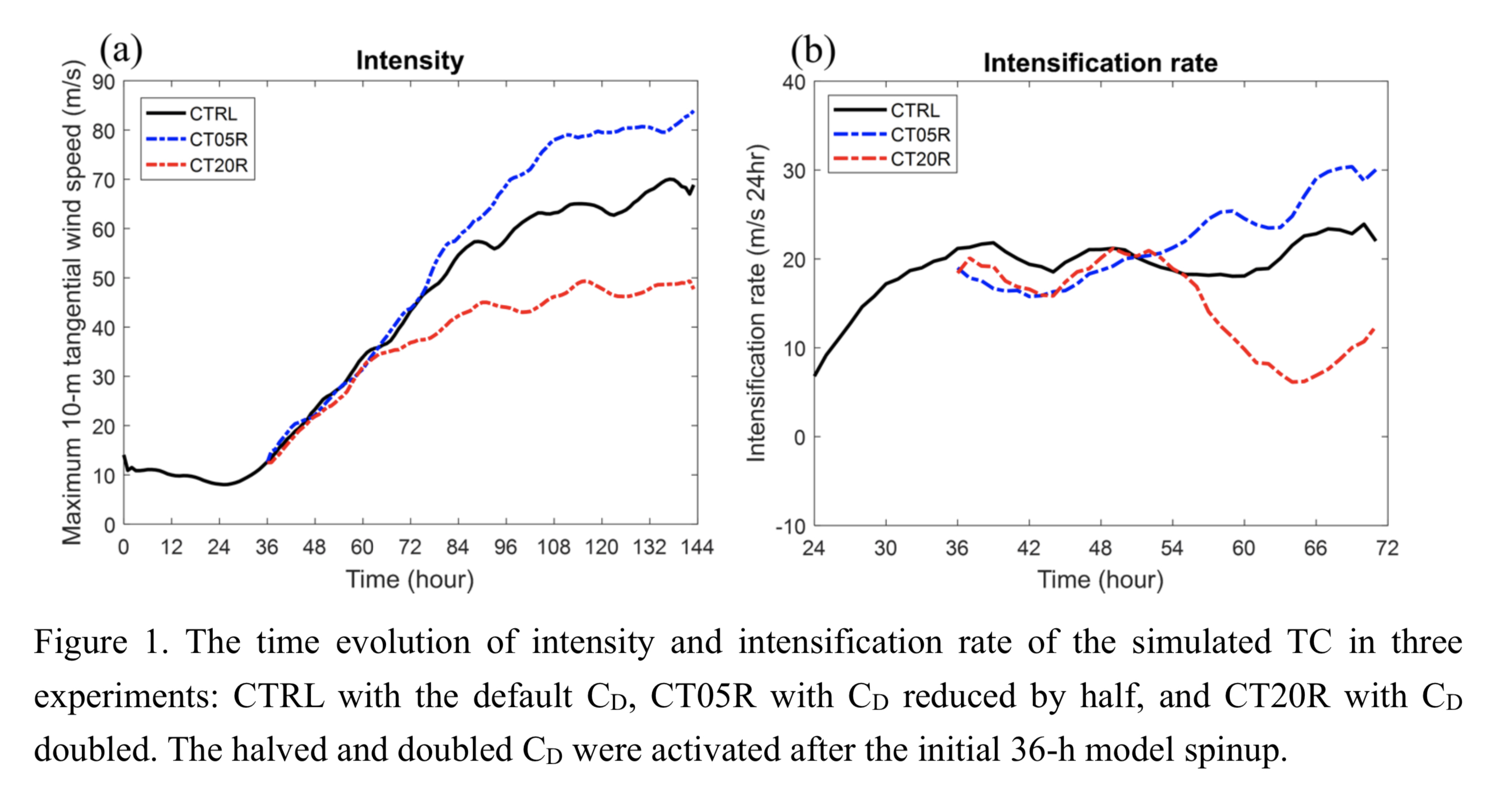
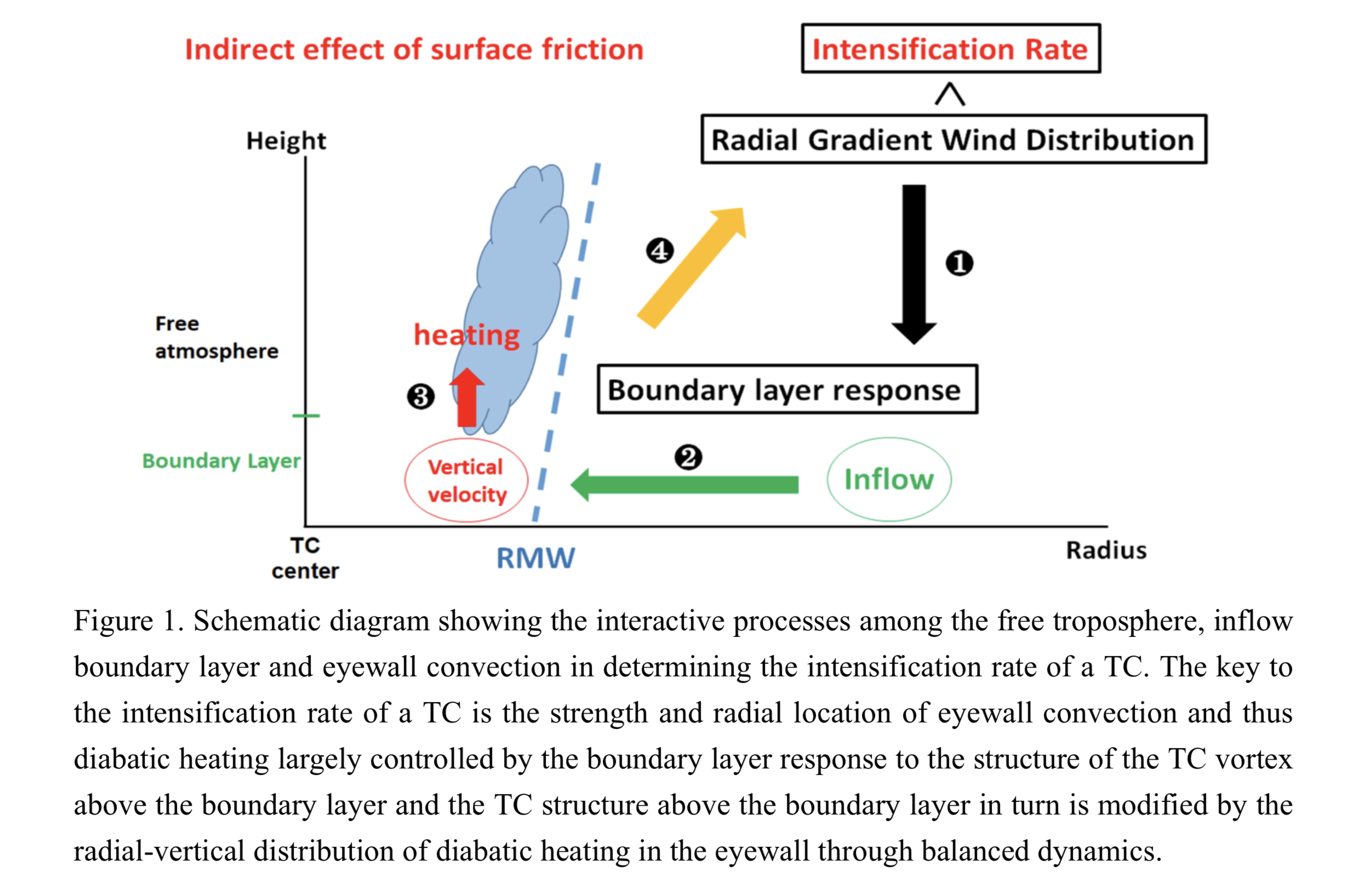
Plain Language Summary: Most previous studies have found that the intensification rate of a tropical cyclone (TC) simulated in high resolution numerical models is often insensitive to surface drag coefficient (CD) or surface friction. A new explanation to this finding has been provided in this study based on the hypothesis that although surface friction has dual opposite effects: negative direct frictional dissipation effect and indirect positive effect by strengthening and inwardly shifting eyewall updrafts/convection. We have demonstrated that the increased/reduced positive indirect effect of surface friction is roughly offset by the increased/reduced negative direct dissipation effect due to increased/reduced CD. As result, the intensification rate of the simulated TC is insensitive to CD (Figure 1). However, increased CD can result in earlier onset of the intensification stage through increasing frictional moisture convergence and Ekman pumping and thus moistening of the inner-core column of the TC vortex, but would lead to a weaker storm in the mature stage.
Highlights:
- Although surface friction has a dissipation effect on kinetic energy of the TC system, it can strengthen and inwardly shift the eyewall updrafts and contributes positively to TC intensification.
- The increased/reduced dual (positive and negative) effects above due to increased/reduced CD are nearly offset each other, leading to an insensitivity of the simulated TC intensification rate to CD.
- Increased CD can lead to increased frictional moisture convergence and Ekman pumping and thus moistening of the inner-core column of the TC vortex and earlier onset of the intensification stage, but would lead to a weaker storm in the mature stage.
Article: Special Edition on DYAMOND: The DYnamics of the Atmospheric general circulation Modeled On Non-hydrostatic Domains
Li and Wang (2021)
Li, T.-H., and Y. Wang, 2021: The role of boundary layer dynamics in tropical cyclone intensification. Part II: Sensitivity to initial vortex structure. J. Meteor. Soc. Japan, 99, 555-573.
Special Edition on DYAMOND: The DYnamics of the Atmospheric general circulation Modeled On Non-hydrostatic Domains
https://doi.org/10.2151/jmsj.2021-028
Graphical Abstract
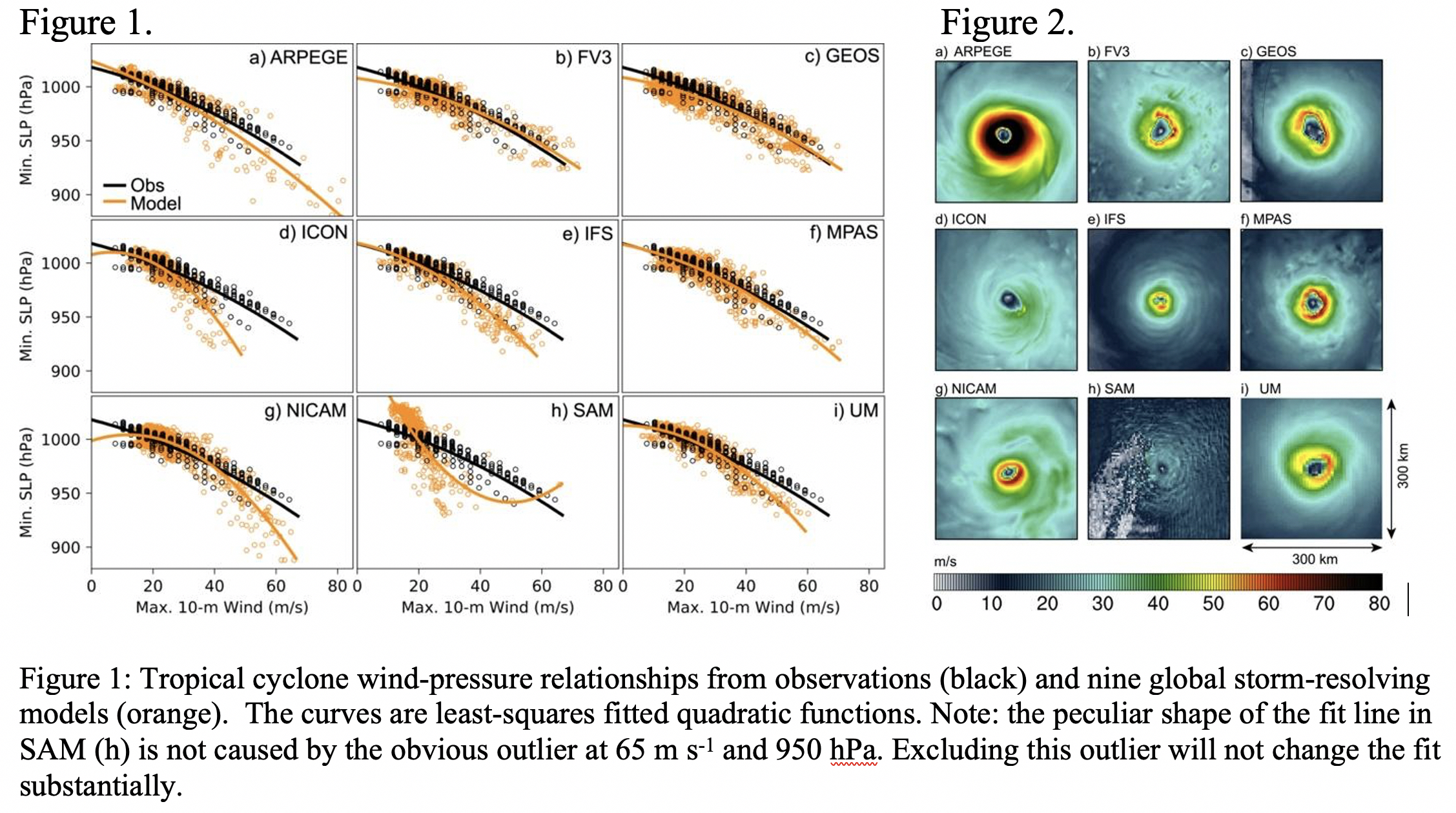
Plain Language Summary: Typhoons and hurricanes (collectively known as tropical cyclones) are one of the most destructive natural phenomena, and their prediction is an important task of weather and climate models. In this study, we evaluated nine global storm-resolving models, that is, models with high enough resolution to explicitly simulate the thunderstorms that make up the cyclone power engine, in their ability to simulate tropical cyclones. We found that the models are able to simulate cyclones more realistically than previous generations of global models. For example, unlike current-generation global models, the tested models are able to capture the cyclone eyewall and its extreme winds. But the models are not perfect, and continued work in improving the models is needed to exploit their full potential in tropical cyclone prediction.
Highlights:
- Global storm-resolving models produce realistic tropical cyclones and remove long standing issues known from global models such as the deficiency to accurately simulate tropical cyclone intensity.
- Tropical cyclones are strongly affected by model formulation, and all models suffer from unique biases regarding the number of cyclones, intensity, size, and structure.
- Some of the nine models investigated here simulated tropical cyclones better than others, but no single model was the “best” in every way.
JMSJ, 2021, Vol. 99, No. 3 (June)
Article: Special Edition on DYAMOND: The DYnamics of the Atmospheric general circulation Modeled On Non-hydrostatic Domains
Judt et al. (2021)
Judt, F., D. Klocke, R. Rios-Berrios, B. Vanniere, F. Ziemen, L. Auger, J. Biercamp, C. Bretherton, X. Chen, P. Düben, C. Hohenegger, M. Khairoutdinov, C. Kodama, L. Kornblueh, S.-J. Lin, M. Nakano, P. Neumann, W. Putman, N. Röber, M. Roberts, M. Satoh, R. Shibuya, B. Stevens, P. L. Vidale, N. Wedi, and L. Zhou, 2021: Tropical cyclones in global storm-resolving models. J. Meteor. Soc. Japan, 99,
Special Edition on DYAMOND: The DYnamics of the Atmospheric general circulation Modeled On Non-hydrostatic Domains
https://doi.org/10.2151/jmsj.2021-029.
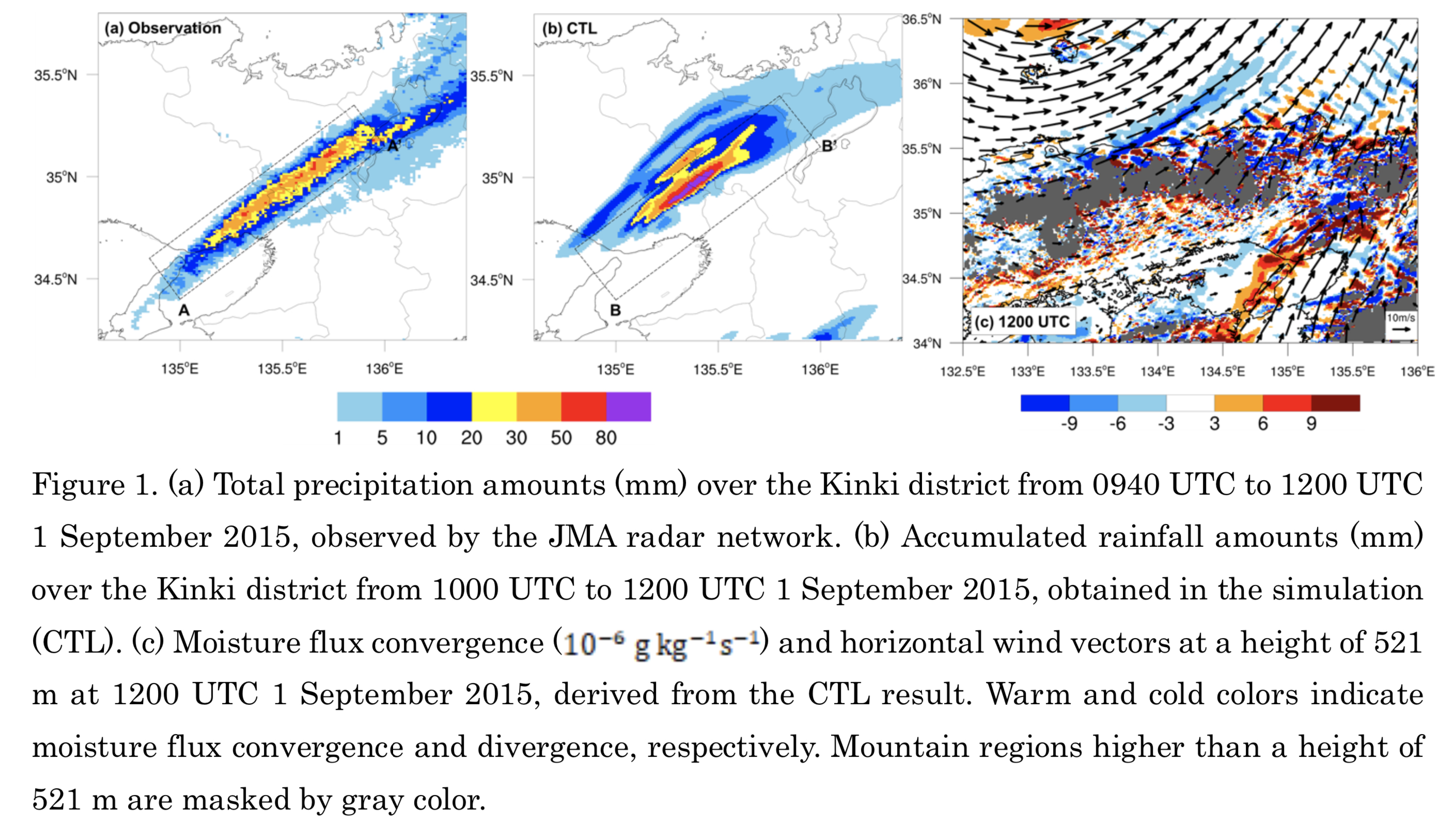
Graphical Abstract
Plain Language Summary: Localized heavy rainfall events with 3-houly accumulated precipitation amounts larger than 200 mm are often observed in Japan. Such events are majorly brought from quasi-stationary band-shaped precipitation systems, named as “senjo-kousuitai” in Japanese. Senjo-kousuitai is defined as a band-shaped heavy rainfall area with the length of 50-300 km and the width of 20-50 km, produced by successively formed and developed convective cells, lining up to organize multi-cell clusters, and passing or stagnating at almost the same place for a few hours.
Highlights:
- This study reviewed previous studies of band-shaped precipitation systems, and also examined the numerical reproducibility of senjo-kousuitai events.
- Characteristics of senjo-kousuitai events are statistically studied based on distributions of 3-hourly accumulated precipitation amounts.
- Six favorable occurrence conditions of senjo-kousuitai events for their diagnostic forecasts were statistically constructed from environmental atmospheric fields in previous events.
Article: Special Edition on Global Precipitation Measurement (GPM): 5th Anniversary
Kobayashi et al. (2021)
Kobayashi T., M. Nomura, A. Adachi, S. Sugimoto, N. Takahashi, and H. Hirakuchi, 2021: Retrieval of attenuation profiles from the GPM dual-frequency radar observations. J. Meteor. Soc. Japan, 99, 603-620.
Special Edition on Global Precipitation Measurement (GPM): 5th Anniversary
https://doi.org/10.2151/jmsj.2021-030
Graphical Abstract
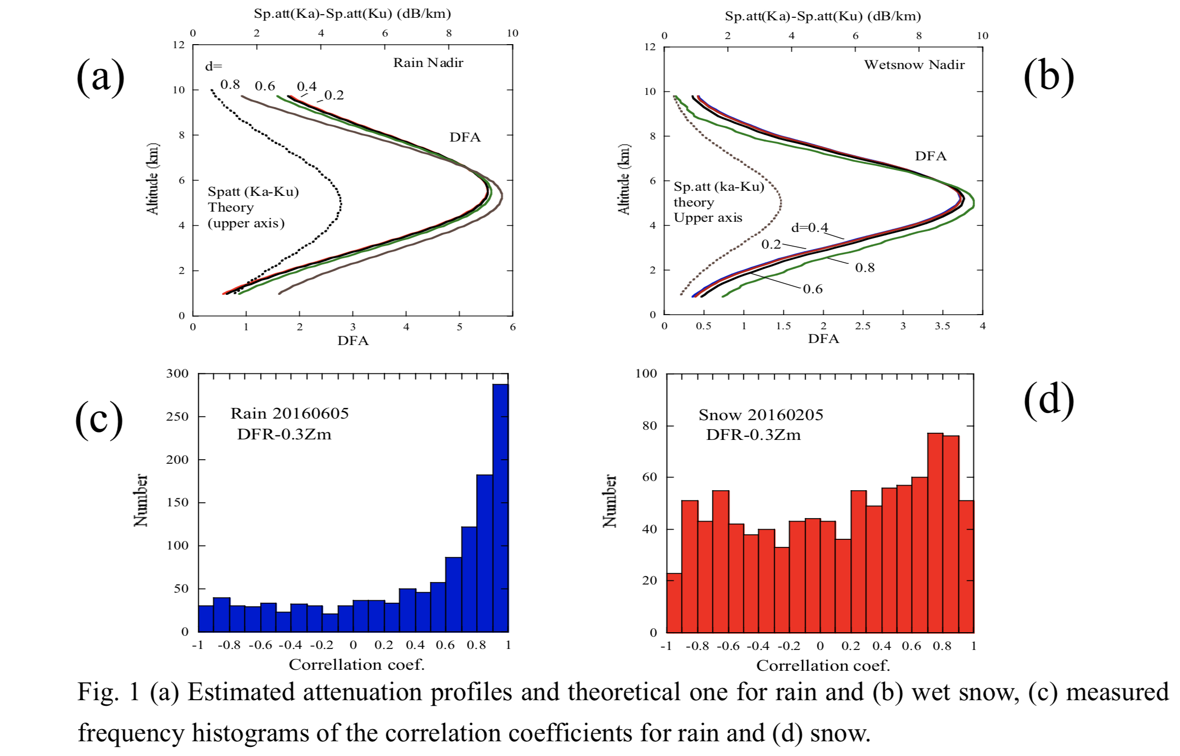
Plain Language Summary: A new method retrieving attenuation profiles using a Dual-Frequency Precipitation Radar equipped on the Global Precipitation Mission (GPM) is proposed. The method utilizes the differential frequency ratio (DFR), which is the difference in the measured reflectivity in the log scale between Ka and Ku bands. The range variations of relative values of differential attenuation between two frequencies are estimated and can be used for identifying hydrometeor types. Simulations indicate that estimated attenuation profiles agree with the shape of theoretical ones for rain, melted snow. The method was applied to identify rain and dry snow regions in the GPM measurements. High and low correlation coefficients between attenuated part of DFR and radar range were observed for rain and dry snow, respectively.
Highlights:
- A new method retrieving attenuation profiles using a Dual-Frequency Precipitation Radar equipped on the GPM is proposed and applied to identify precipitation type.
- The method was evaluated using numerical simulations and measurements.
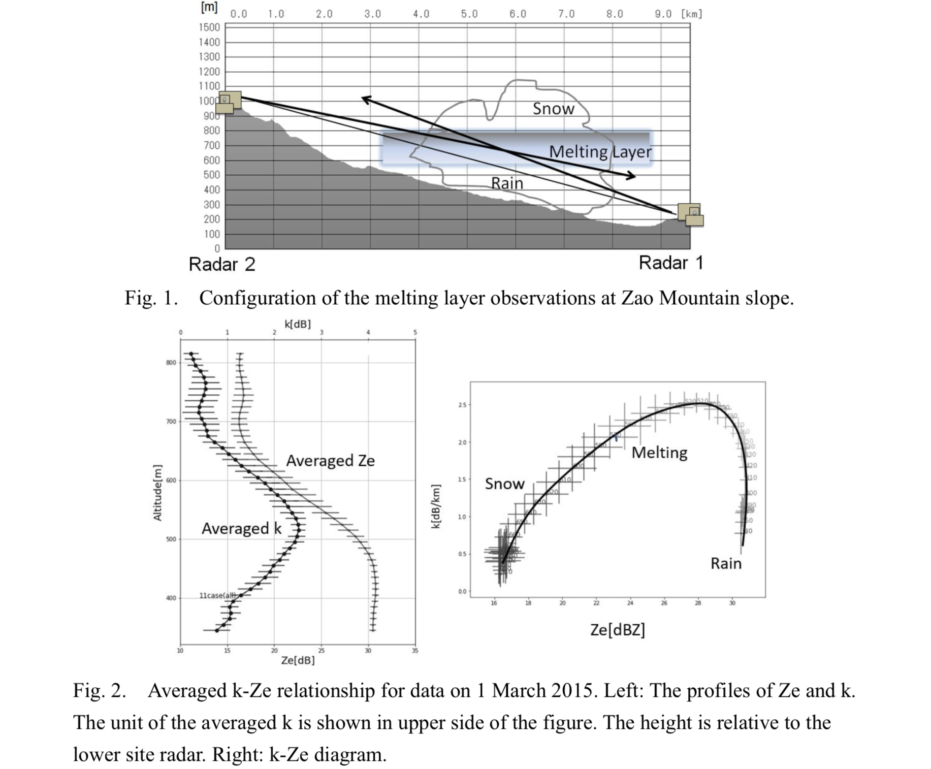
- A technique to estimate the ratio of total attenuations of the melting layer to attenuation below the melting layer is also presented.
Article
Cheng and Suzuki (2021)
Cheng, C. T., and K. Suzuki, 2021: Size-resolved aerosol microphysics in a global nonhydrostatic atmospheric model: Model description and validation. J. Meteor. Soc. Japan, 99,
https://doi.org/10.2151/jmsj.2021-031.
Graphical Abstract
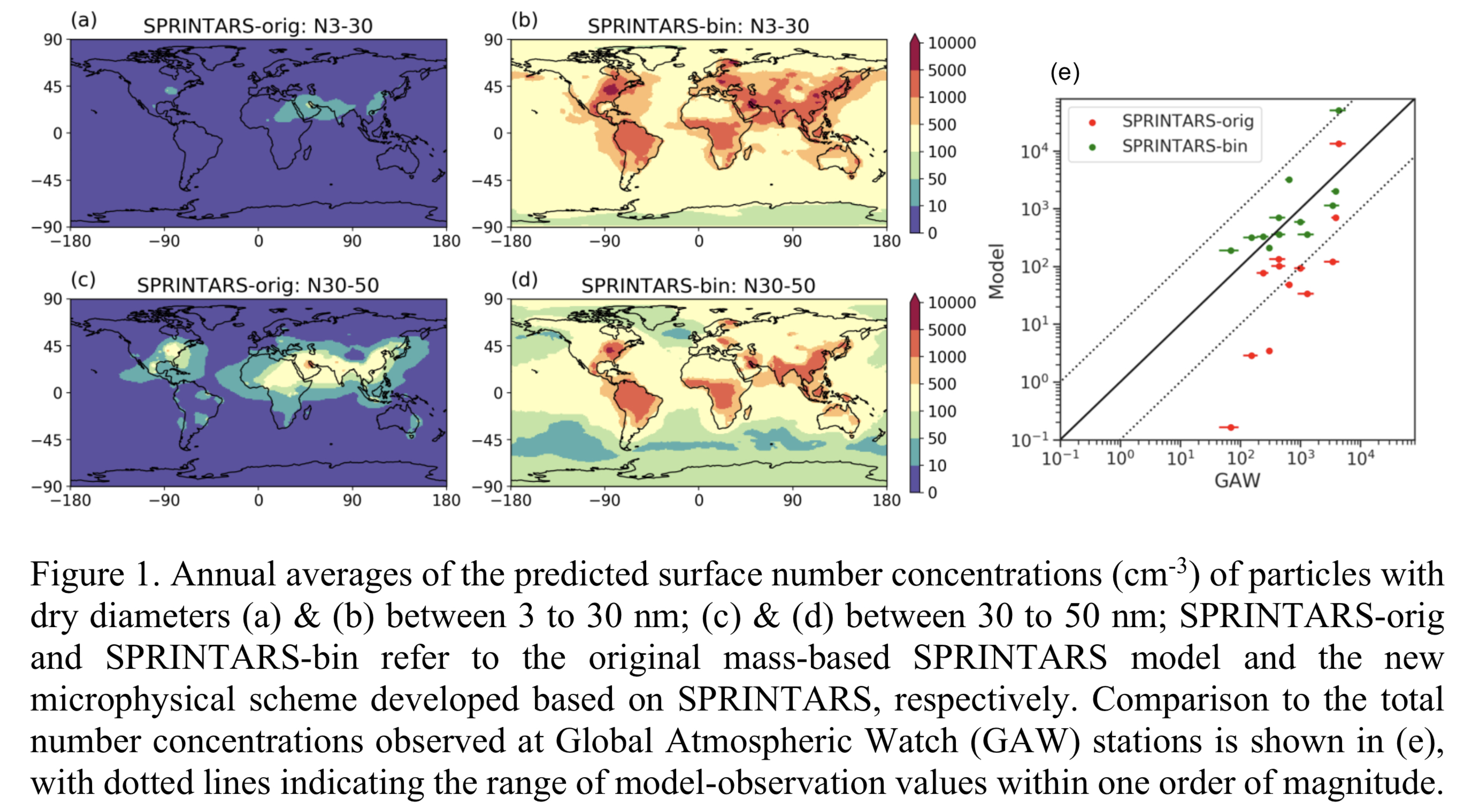
Plain Language Summary: Particle size determines the aerosol transport and removal processes, as well as how aerosol interacts with clouds and climate. In this study, we develop a sectional aerosol scheme for Spectral Radiation-Transport Model for Aerosol Species (SPRINTARS-bin) which explicitly simulates the variations in size distributions due to microphysical processes. SPRINTARS-bin is implemented in NICAM (Nonhydrostatic ICosahedral Atmospheric Model) as an alternative to the original mass-based SPRINTARS-orig aerosol module. Both schemes are evaluated by comparing year-long simulation results to ground-based measurements and satellite observations to find that the sectional scheme with better representations of ultra-fine particles largely alleviates underestimates of the aerosol number concentration in the original scheme.
Highlights:
- NICAM-SPRINTARS-bin demonstrates the long-range transport of ultra-fine particles to high latitudes, as found in surface number concentrations.
- The differences can be explained by the new capability of NICAM-SPRINTARS-bin to resolve microphysical processes that determine the particle concentrations of ultra-fine aerosol particles, in contrast to the prescribed size distributions in NICAM-SPRINTARS-orig.
- The sectional scheme predicts higher Angstrom Exponent and total number concentrations, and better agrees with ground-based measurements in terms of annual averages. Seasonal variations are also reproduced at several sites.
Article
Cui et al. (2021)
Cui, Y., Z. Ruan, M. Wei, F. Li, R. Ge, and Y. Huang, 2021: Vertical evolution of microphysical properties during snow events in middle latitudes of China observed by a C-band vertically pointing radar. J. Meteor. Soc. Japan, 99, 649-671.
https://doi.org/10.2151/jmsj.2021-032
Graphical Abstract
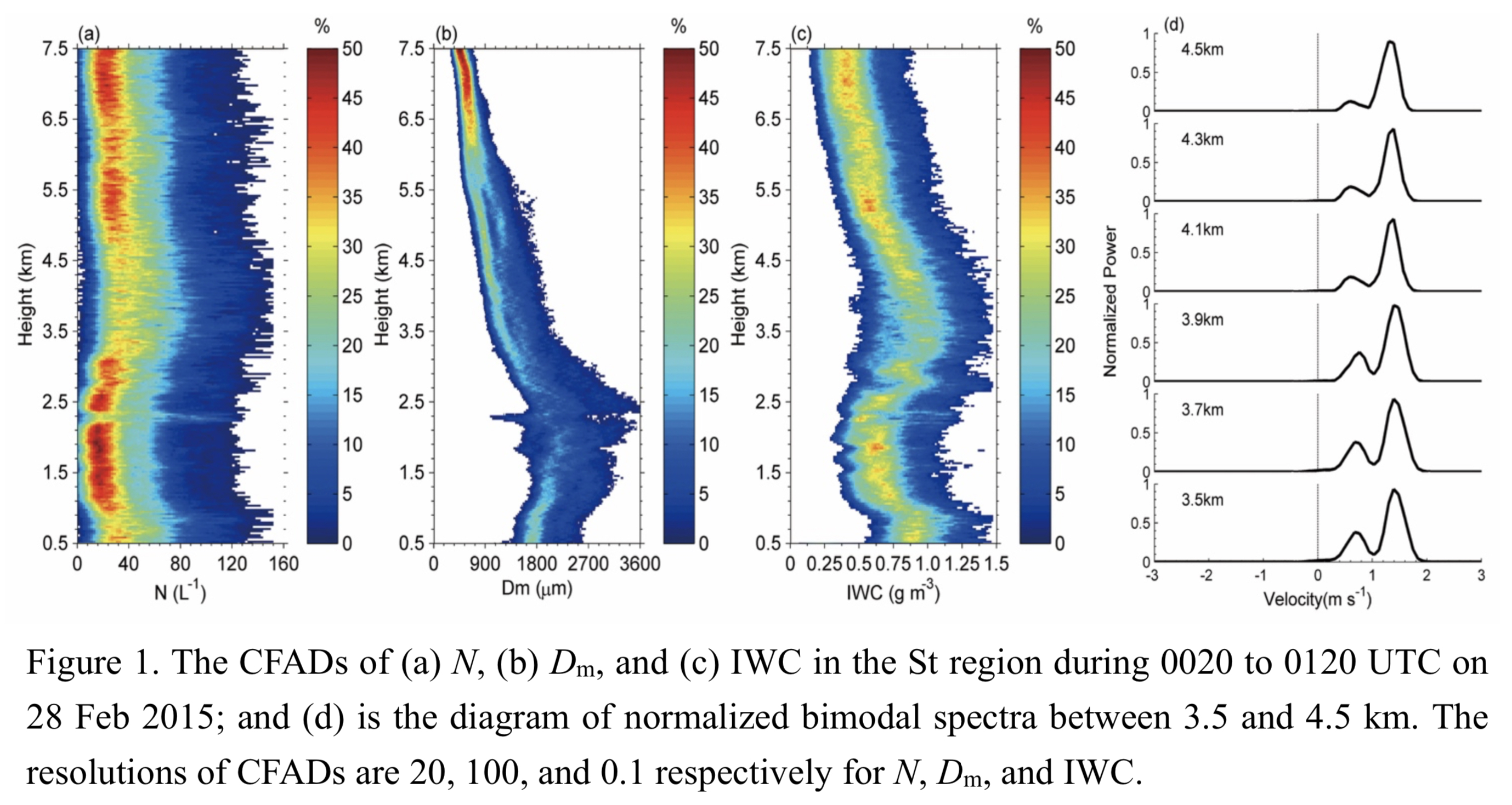
Plain Language Summary: The snow clouds were divided into upper generating cell (GC) and lower stratiform (St) regions according to their vertical structure. The growth of particle size and mass mainly occurred in the St regions. The increases of ice particle number concentration (N) were usually observed near −5°C accompanied by bimodal Doppler spectra, which might be caused by ice multiplication. The average ratios of the median N, median mass diameter (Dm), and ice water content (IWC) inside GCs to those outside GCs are 2, 1.3, and 2.5 respectively for shallow events, with 1.7, 1.2, and 2.3 respectively for deep events. These values were basically the same as those for the fall streaks (FSs), implying the importance of GCs to the enhanced ice growth subsequently found in FSs. The larger values of N, Dm, and IWC inside GCs could be related to the upward air motions inside GCs. The first Ze–IWC relationship suitable for snow clouds in the midlatitudes of China was also established.
Highlights:
- In this study, the N, Dm and IWC values were retrieved more precisely by using Doppler spectra from CVPR-FMCW.
- The differences in N, Dm, and IWC between the inside and outside of GCs and FSs were discussed associated with the dynamical properties.
- The first Ze–IWC relationship suitable for snow clouds in the midlatitudes of China was established, and the possibility of studying IWC in snow clouds through Ze observed by ground-based radar was discovered.
Notes and Correspondence: Special Edition on Global Precipitation Measurement (GPM): 5th Anniversary
Yamaji et al. (2021)
Yamaji, M., T. Kubota, and M. K. Yamamoto, 2021: An approach to reliability characterization of GSMaP near-real-time precipitation product. J. Meteor. Soc. Japan, 99, 673-684.
Special Edition on Global Precipitation Measurement (GPM): 5th Anniversary
https://doi.org/10.2151/jmsj.2021-033
Graphical Abstract
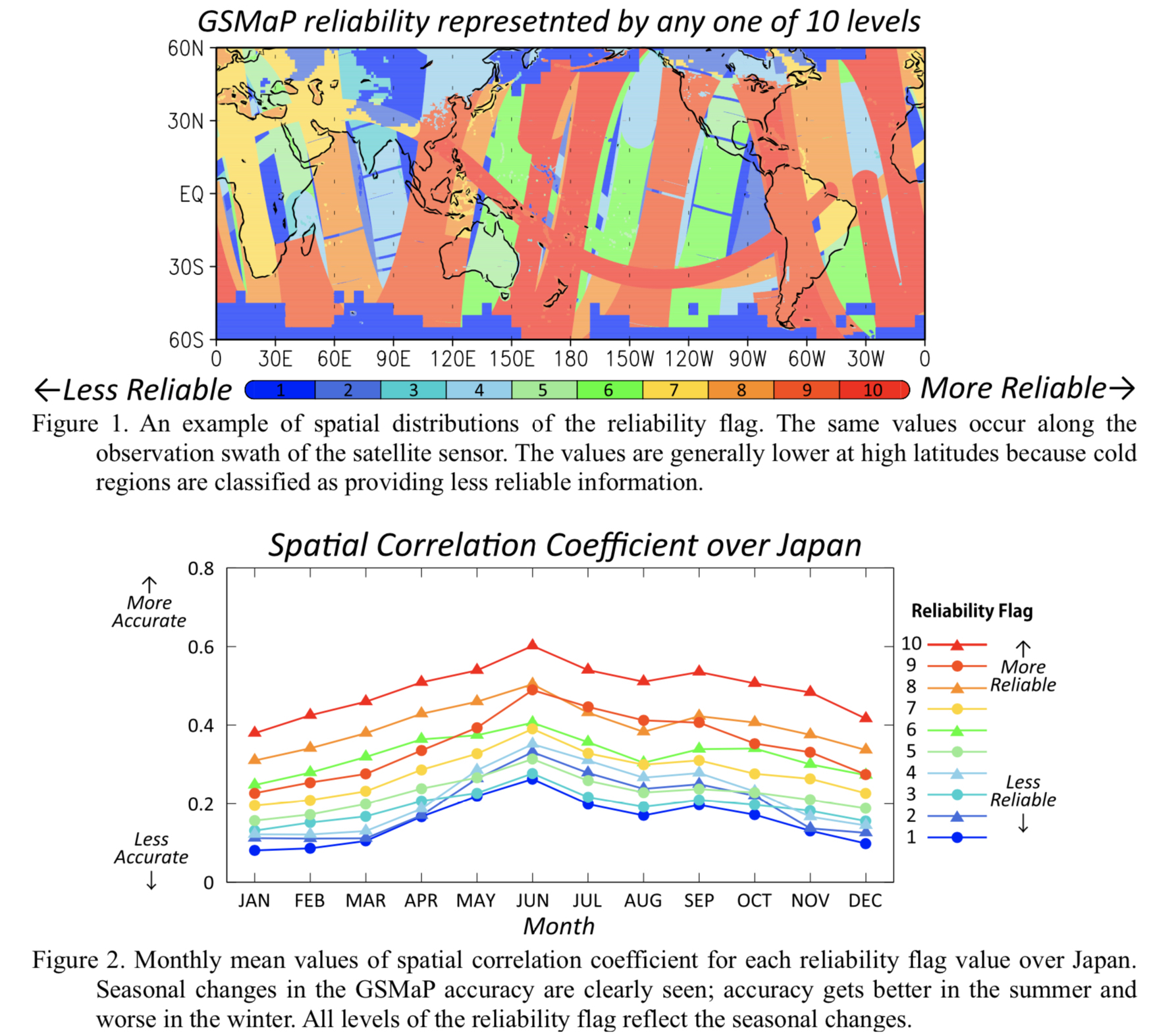
Plain Language Summary: Reliability information of satellite precipitation products is required for various applications, such as agricultural monitoring, public health, and education, as well as weather monitoring and disaster prevention. This study confirms effectiveness for a reliability flag of the Global Satellite Mapping of Precipitation Near-Real-Time precipitation product (GSMaP_NRT), which is developed to characterize the reliability of GSMaP_NRT data “simply” and “qualitatively”.
Highlights:
- We described the algorithm of the GSMaP_NRT reliability flag (Fig. 1), considering three major factors, and found that the flag represents the differences in GSMaP accuracy.
- Seasonal changes in the GSMaP errors were well represented by the reliability flag (Fig.2).
- This study also raises the possibility of improving the reliability flag by using information related to heavy orographic rainfall by showing how the error features of heavy orographic rainfall differ from those of the total rainfall.
Notes and Correspondence
Takata and Hanasaki (2021)
Takata, K., and N. Hanasaki, 2021: Investigating runoff sensitivity in the land-surface model MATSIRO to reduce low runoff bias. J. Meteor. Soc. Japan, 99, 685-695.
https://doi.org/10.2151/jmsj.2021-034
Graphical Abstract
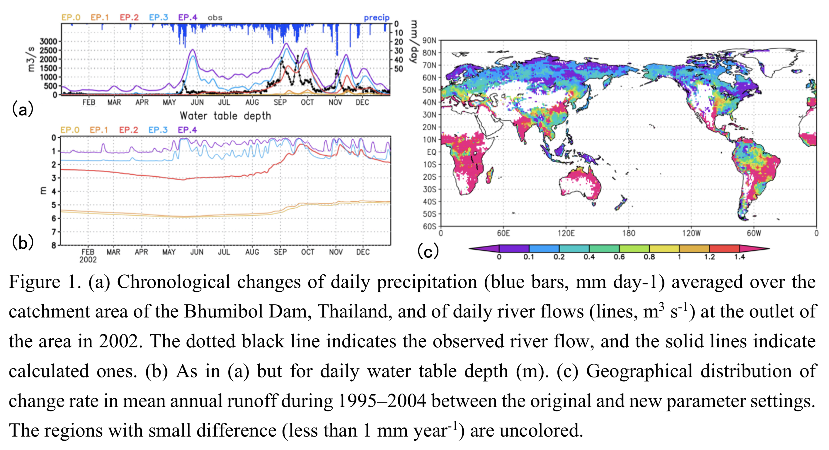
Plain Language Summary: Runoff calculated with the Minimal Advanced Treatments of Surface Interaction and RunOff (MATSIRO) on the basis of TOPography-base MODEL (TOPMODEL) tends to be too low and its response to precipitation be too low, compared to observation for instance in Thailand. We conjectured that those biases could be attributed to the water table's excessive depth, which was diagnosed from grid-mean soil moisture using a saturation parameter. The results of Sensitivity for the parameter were then investigated aiming to make the response more active at a catchment in Thailand. The results presented marked increases in runoff accompanying reduction in water table depth. The preliminary global sensitivity experiments indicated spatial variations of the sensitivity with climate zones.
Highlights:
- Sensitivity of runoff with MATSIRO was investigated with regard to a parameter that relate grid- mean soil moisture with water table depth, aiming to reduce low runoff biases and to enhance its responses to precipitation.
- The parameter was changed from the original value (experiment EP.0), with which saturation judgement in diagnosing water table depth has been strict to grid-mean soil moisture, to the relaxed values (experiments EP.1, EP.2, EP.3 and EP.4).
- The simulation results for the catchment area of the Bhumibol Dam, Thailand, presented marked increase in runoff accompanying reduction in water table depth.
- The preliminary global sensitivity experiments where the parameter values are same as EP.0 and EP.2 indicated spatial variations of the sensitivity with climate zones.
Review Article: Special Edition on Global Precipitation Measurement (GPM): 5th Anniversary
Nakamura, K. (2021)
Nakamura, K., 2021: Progress from TRMM to GPM. J. Meteor. Soc. Japan, 99, 697-729.
Special Edition on Global Precipitation Measurement (GPM): 5th Anniversary
https://doi.org/10.2151/jmsj.2021-035
Graphical Abstract
Plain Language Summary:
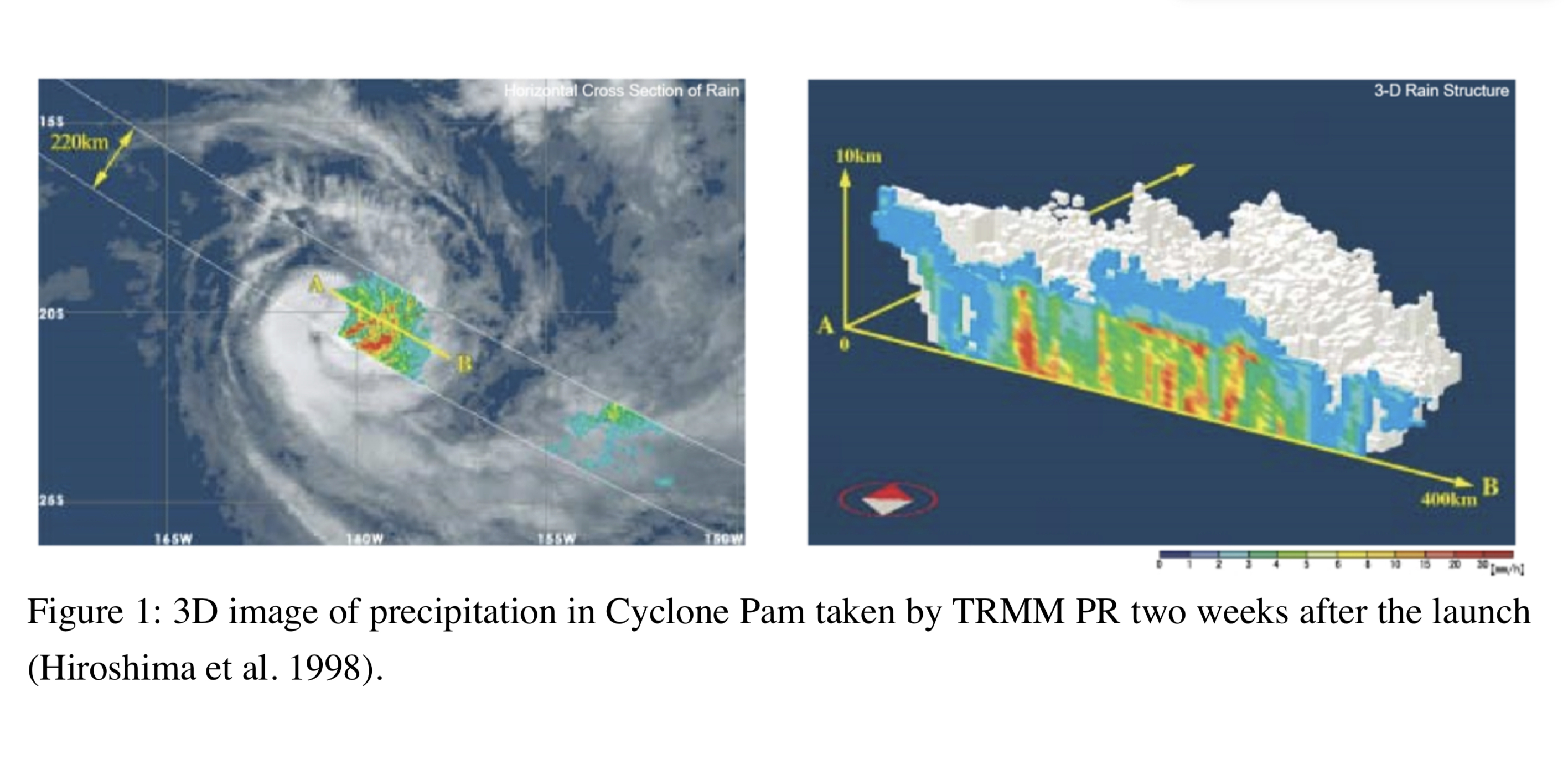
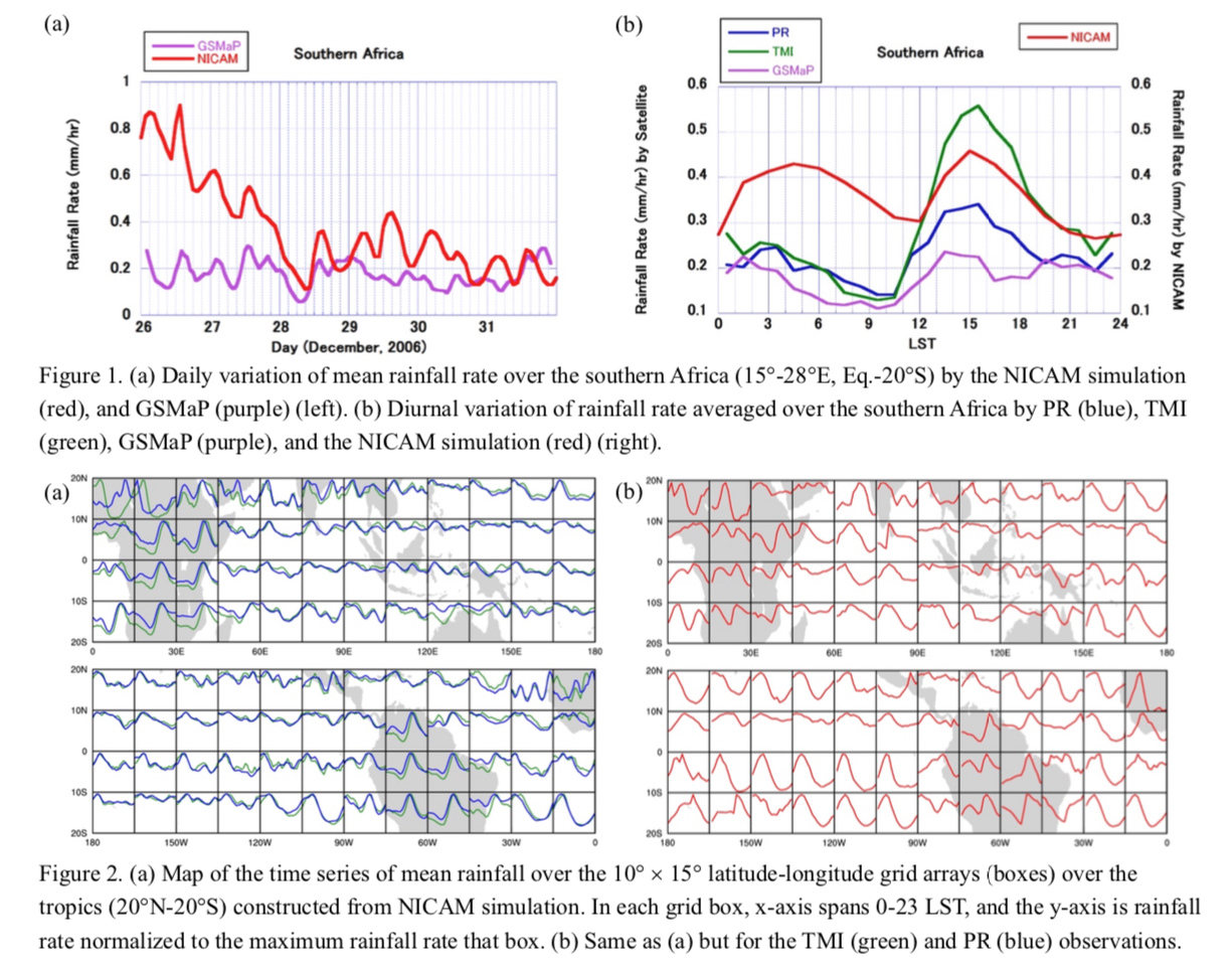
The Tropical Rainfall Measuring Mission (TRMM) satellite was launched in 1997, and the observations continued for more than 17 years. The features of TRMM observation were as follows:
- It followed a non-sun synchronized orbit that enabled the diurnal variation of precipitation to be investigated.
- It carried a precipitation radar (PR) and microwave and infrared radiometers along with a lighting sensor and a radiation budget sensor, which enabled the study of the global characteristics of precipitation systems, as an example shown in Fig. 1.
- It worked as a standard reference for precipitation measurements for other spaceborne microwave radiometers, which enabled global rain maps to be developed.
Highlights:
-
The paper describes the progress from the Tropical Rainfall Measuring Mission (TRMM) to the Global Precipitation Measurements (GPM) highlighting Japan’s contributions.
- TRMM’s main feature is that it carried the first space-borne precipitation radar which enabled the three-dimensional structure of precipitation globally.
- GPM extended the coverage of TRMM to mid- and high-latitude regions.
- The utilizations of the global precipitation maps have widely expanded.
Notes and Correspondence
Yamada (2021)
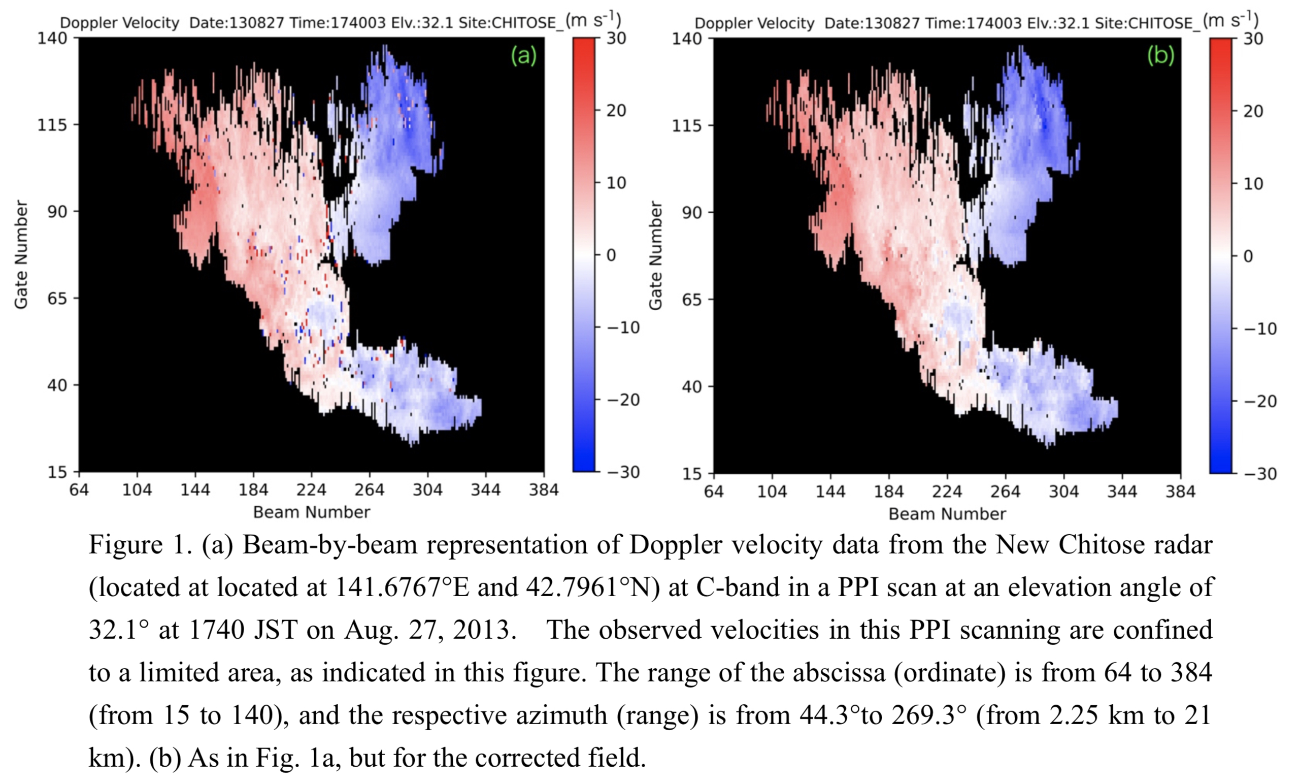
Yamada, Y., 2021: An efficient practical post-processing algorithm for the quality control of dual-PRF Doppler velocity data. J. Meteor. Soc. Japan, 98, 707-733.
https://doi.org/10.2151/jmsj.2021-036
Graphical Abstract
Plain Language Summary: In this study, the impacts of Typhoon Morakot’s (2009) vortex structure on the extreme rainfall in Taiwan are investigated through modeling with an application of piecewise potential vorticity (PV) inversion. The control experiment (C0), starting at 0000 UTC 7 August or 15 h before landfall, reproduces the event realistically and is validated against the observations. By altering the PV perturbation inside 750 km from its center, we conduct sensitivity experiments in which the size and/or circulation strength of Morakot is reduced/weakened in the initial field in several different ways.
Highlights:
- Taiwan receives an overall rainfall amount either comparable to, or even more than (up to +12%), C0 in all tests. This result shows the strong southwesterly flow and its moisture supply were bigger factors than the vortex structure.
- In the southern Central Mountain Range on 8 August, the rainfall tended to decrease by up to 40% with the contraction and a weaker outer circulation, indicating that the vortex structure plays an important role in the rainfall of this region.
Article: Special Edition on Global Precipitation Measurement (GPM): 5th Anniversary
Kumar et al. (2021)
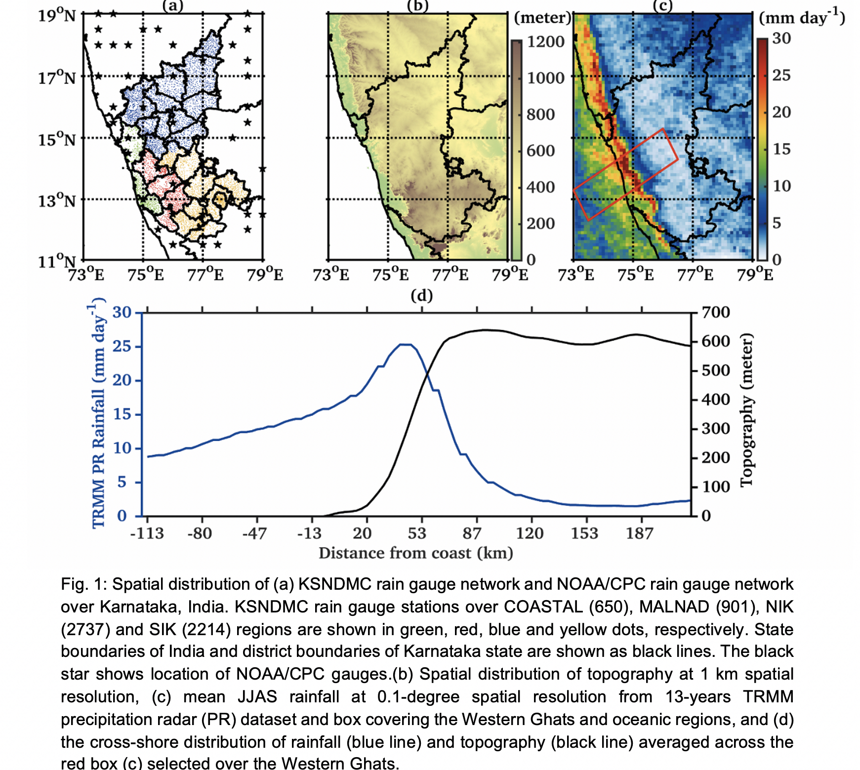
Kumar, P., R. M. Gairola, T. Kubota, and C. M. Kishtawal, 2021: Hybrid assimilation of satellite rainfall product with high density gauge network to improve daily estimation: a case of Karnataka, India. J. Meteor. Soc. Japan, 99, 741-763.
Special Edition on Global Precipitation Measurement (GPM): 5th Anniversary
https://doi.org/10.2151/jmsj.2021-037
Graphical Abstract
Plain Language Summary: After initial verification of GSMaP rainfall product against dense rain gauge network over a southwestern state of India, a hybrid assimilation method is developed in this study to prepare merge rainfall product. The hybrid assimilation method, a combination of variational method and Kalman filter, demonstrated importance of advance data assimilation over objective analysis and optimal interpolation methods, widely used for generating merge rainfall product. Moreover, study suggested that both assimilation technique and density of rain gauges are crucial for preparing final rainfall product.
Highlights:
- Verification of GSMaP rainfall product against dense rain gauge network over a southwestern state of India suggested large errors over the orographic heavy rainfall region of the Western Ghats. The hybrid assimilation method improved GSMaP rainfall product majorly over orographic heavy rainfall regions.
- This study recognized that both assimilation technique and density of rain gauges are crucial to generate final merge rainfall product.
Article
Moroda et al. (2021)
Moroda, Y., K. Tsuboki, S. Satoh, K. Nakagawa, T. Ushio, and S. Shimizu, 2021: Structure and evolution of precipitation cores in an isolated convective storm observed by phased array weather radar. J. Meteor. Soc. Japan, 99, 765-784.
https://doi.org/10.2151/jmsj.2021-038
Graphical Abstract
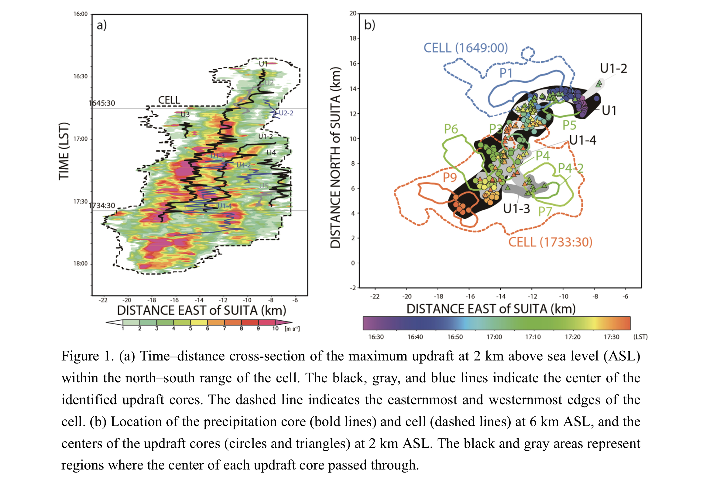
Plain Language Summary: An isolated convective storm was observed by two phased array weather radars (PAWRs) that can perform one volume scan in just 30 seconds. The storm caused localized heavy rainfall on 7 August 2015 in the Kinki District, western Japan. We described the evolution of the storm in terms of precipitation cores and updraft cores that were clearly defined using threshold values of radar reflectivity and vertical velocity. We found that the isolated storm exhibited structures of multi-precipitation cores and multi-updraft cores.
Highlights:
- The observations of two PAWRs enable us to perform dual-Doppler analysis every 30 seconds.
- The storm had nine precipitation cores and five updraft cores. All the precipitation cores were observed along the trajectory of a major updraft core and its branches.
- The evolutions of the precipitation cores and updraft cores were different, although they influenced each other.
JMSJ, 2021, Vol. 99, No. 4 (August)
Article
Bui and Yu (2021)
Bui, H. X., and J.-Y. Yu, 2021: Impacts of model spatial resolution on the simulation of convective spectrum and the associated cloud radiative effect in the tropics. J. Meteor. Soc. Japan, 99, 789-802.
https://doi.org/10.2151/jmsj.2021-039
Graphical Abstract
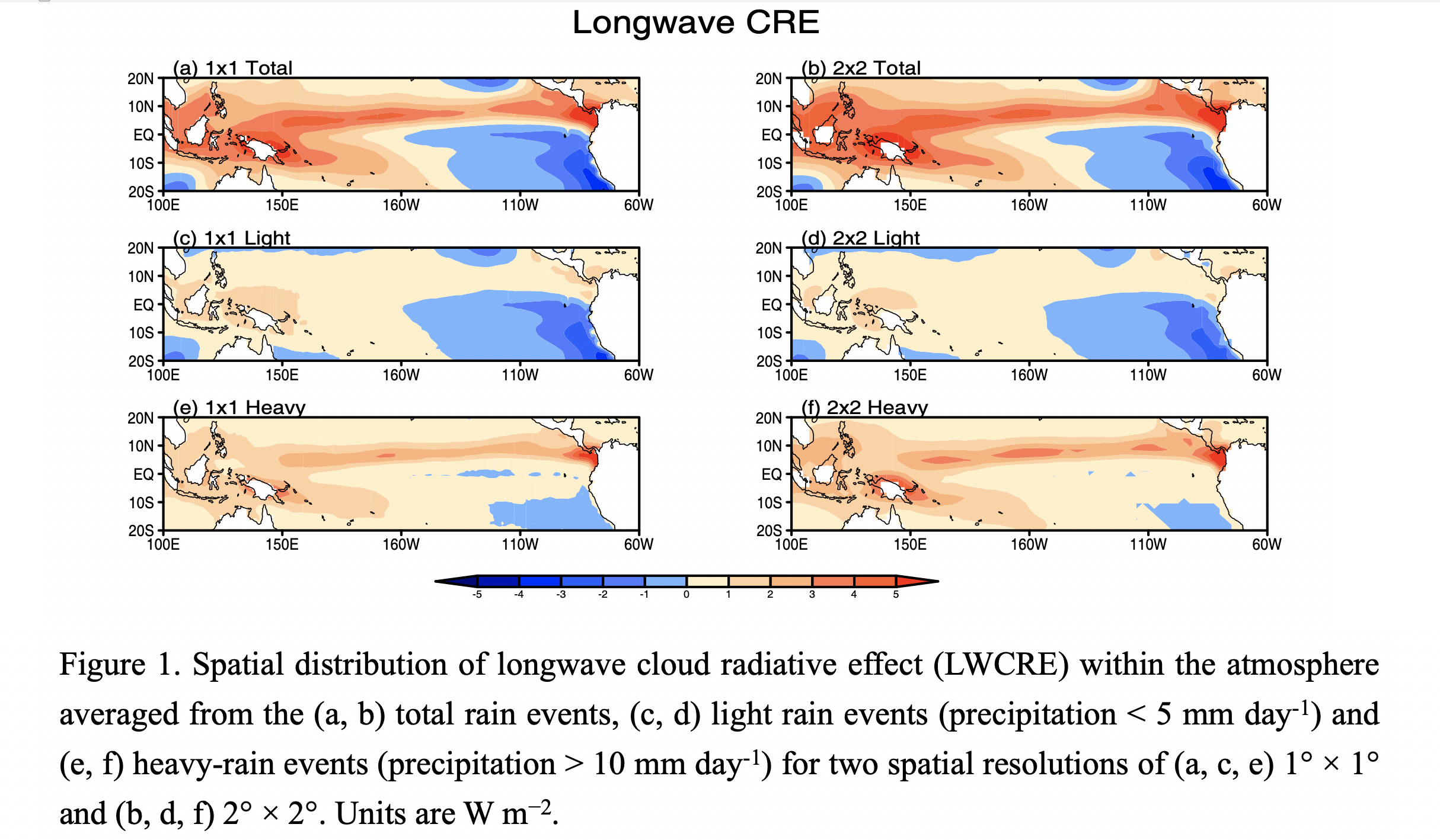
Plain Language Summary: In this study, we examine the resolution dependence of convective spectrum in CAM5 (Community Atmospheric Model version 5) simulations, focusing on the transition from shallow to deep convection and the associated cloud radiative effect (CRE) change. We find that the convective spectrum is sensitive to model spatial resolution, with more deep convection in the coarser resolution runs. Moreover, the longwave component of CRE (LWCRE) is more sensitive to the change of model resolution compared to the shortwave component of CRE (SWCRE), characterized by a stronger response in the coarser resolution runs over the heavy-rain regime. The resolution dependence of convective spectrum and CRE changes highlights the importance of scale-aware cumulus parameterization design in climate models, which is not yet implemented in CAM5.
Highlights:
- The resolution dependence of convective spectrum in the tropics is examined based on CAM5 simulations at four different spatial resolutions.
- The critical bins marking the transition from shallow to deep convection increase as the model resolutions increase and LWCRE is more sensitive to model resolution compared to SWCRE.
- The resolution dependence of convective spectrum and CRE changes highlights the importance of scale-aware cumulus parameterization design in climate models.
Review Article
Haynes et al. (2021)
Haynes, P., P. Hitchcock, M. Hitchman, S. Yoden, H. Hendon, G. Kiladis, K. Kodera, and I. Simpson, 2021: The influence of the stratosphere on the tropical troposphere. J. Meteor. Soc. Japan, 99, 803-845.
https://doi.org/10.2151/jmsj.2021-040
Graphical Abstract
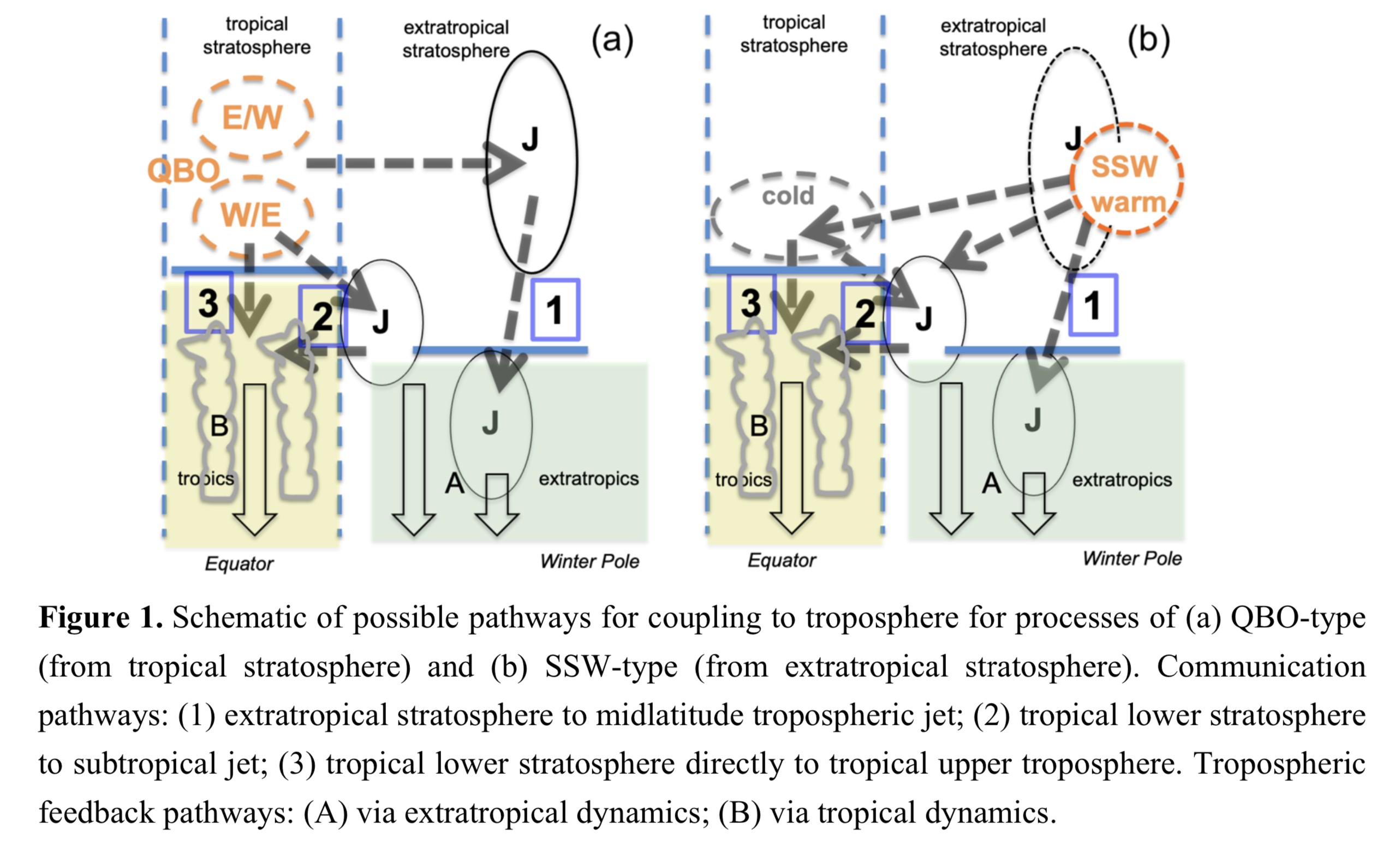
Plain Language Summary: Observational and model studies suggest that the stratosphere exerts a significant influence on the tropical troposphere. Such influence requires both communication of dynamical effects from stratosphere to troposphere and feedbacks within the troposphere which enhance the tropospheric response. This review summarises the current observational and modelling evidence for stratospheric influence on the tropical troposphere, on timescales ranging from diurnal to centennial, identifies outstanding scientific questions and discusses implications for weather and climate prediction.
Highlights:
- Potentially important pathways and feedbacks are identified.
- The recently identified connection between the Quasi-Biennial Oscillation (QBO) and the Madden-Julian Oscillation is highlighted as an opportunity to test many different aspects of scientific understanding of the tropical atmosphere.
- The use of different models, including free-running climate models, seasonal forecast models and convection resolving models, is discussed and examples are described from model investigations of the influence of stratospheric sudden warmings (SSW), the stratospheric QBO, stratospheric geoengineering and ozone-climate interactions.
- The connection to ongoing discussions in the tropospheric climate community on future changes in tropical convection and precipitation is emphasised.
Review Article
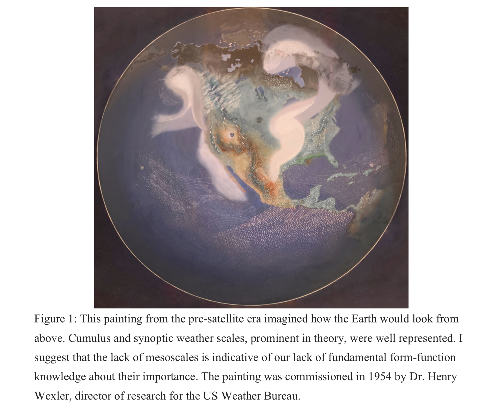
Mapes (2021)
Mapes, B., 2021: Toward form-function relationships for mesoscale structure in convection. J. Meteor. Soc. Japan, 99, 847-878.
https://doi.org/10.2151/jmsj.2021-041
Graphical Abstract
Plain Language Summary: Mesoscale patterns are always observed in convective cloud fields. But there is a gap in theory and understanding about whether and how these patterns matter to the larger-scale weather in its entirety. This review essay spotlights that gap, and offers a formal framework for research to address it. Could patterns and textures detected by imagery artificial intelligence, become a tangible and useful new form of semi-quantitative data? Perhaps, but only if we can better understand what the patterns signify.
Highlights:
- Form and function are defined, and form-function relationships are reviewed, with older science disciplines as models.
- Hypotheses from the literature about how mesoscale patterns affect convection’s impacts and interactions are reviewed.
- A framework for categorizing research approaches is staked out, and scientific gaps and opportunities are highlighted.
Article
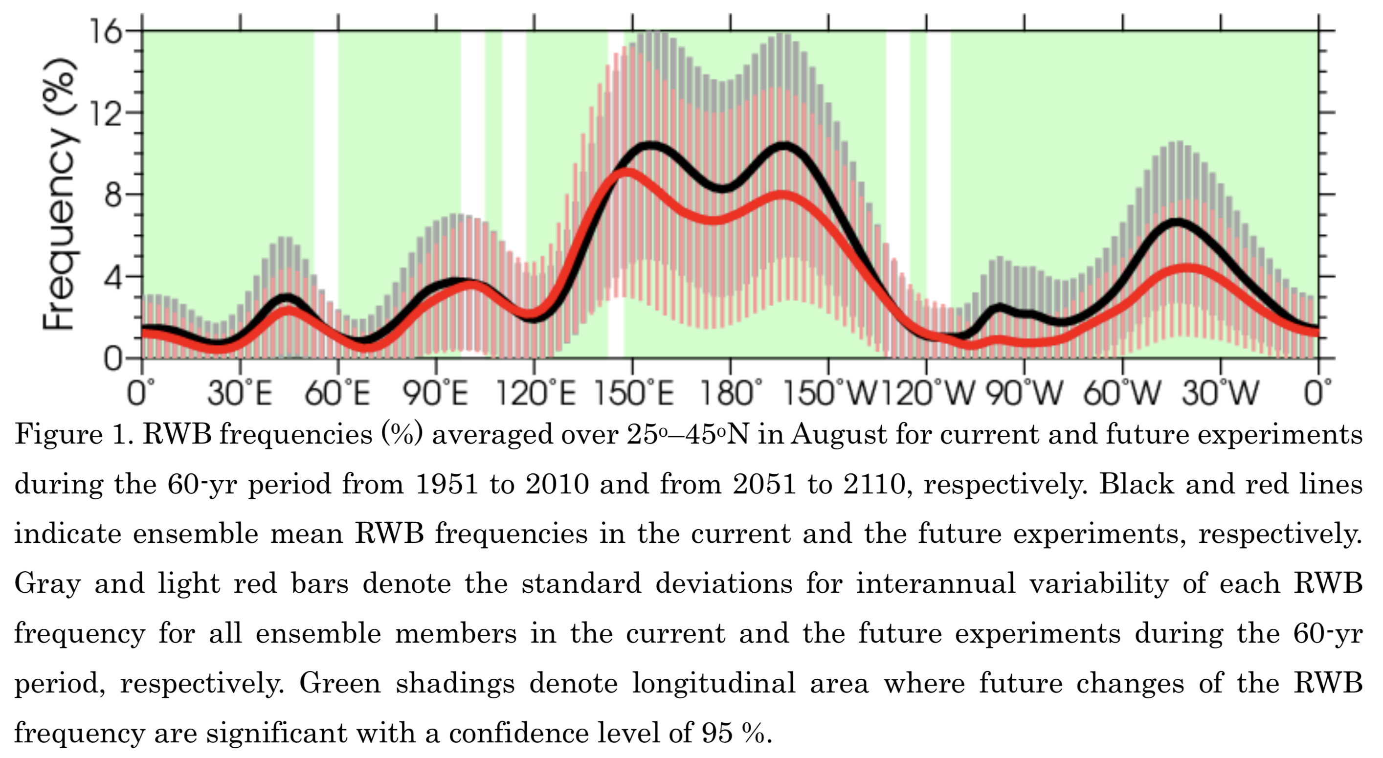
Takemura et al. (2021)
Takemura, K., H. Mukougawa, and S. Maeda, 2021: Decrease of Rossby wave breaking frequency over the middle North Pacific in boreal summer under global warming in large-ensemble climate simulations. J. Meteor. Soc. Japan, 99, 879-897.
https://doi.org/10.2151/jmsj.2021-042
Graphical Abstract
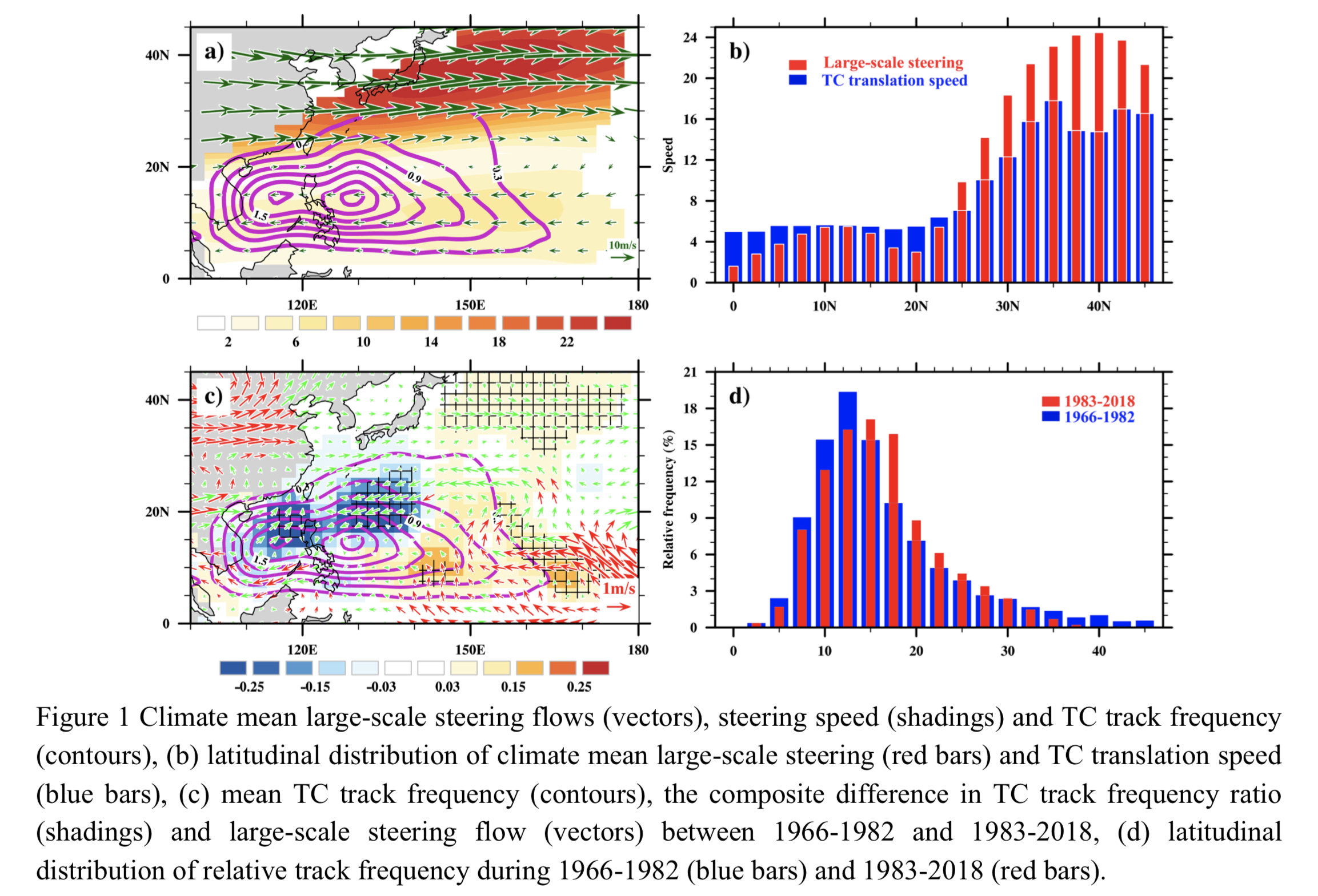
Plain Language Summary: Future change of Rossby wave breaking (RWB) frequency over the middle North Pacific (MNP) in August under global warming and related features of large-scale atmospheric circulation are examined using large-ensemble simulations of current and future climates with a global circulation model. The main findings are summarized as follows.
Highlights:
- The RWB frequency in the future climate shows significant decreases over the MNP, compared to that in the current climate.
- The large-scale atmospheric circulation in the upper troposphere in the future climate indicates a significant weakening of the Asian summer monsoon circulation and the consequent southward shifted Asian jet, resulting in the decreased RWB frequency over the MNP through reduced diffluence and deceleration of the jet over the region.
- Rossby wave propagation over Eurasia and the North Pacific in mid-latitudes is also clearly reduced in the future climate, consistent with the decreased RWB frequency over the MNP.
- Correlation analysis and quasi-geostrophic diagnosis further indicate that the decreased RWB frequency over the MNP has a dynamical impact on suppressed convective activities east of the Philippines in the future climate, through the weakened extension of the Mid-Pacific trough and the consequent weakening of dynamically induced ascent east of the Philippines.
Article
Hirata et al. (2021)
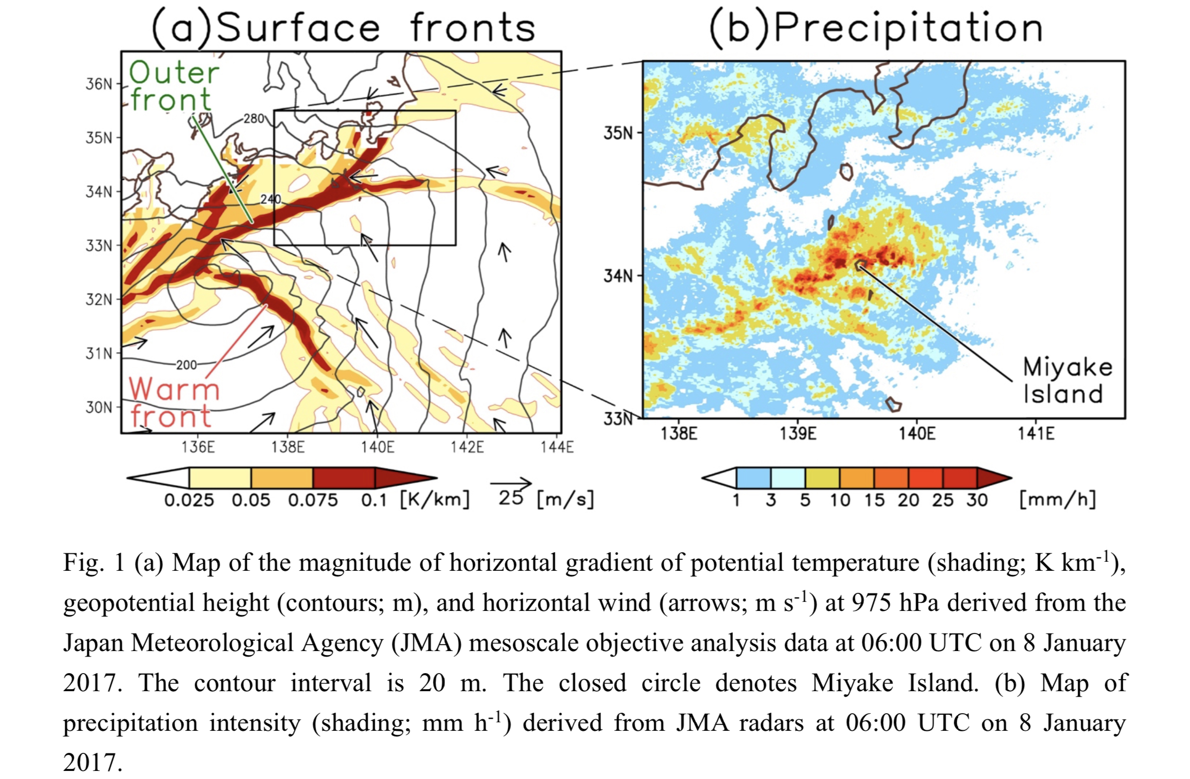
Hirata, H., R. Kawamura, M. Nonaka, and K. Tsuboki, 2021: Kuroshio-enhanced convective rainband associated with an extratropical cyclone in the cold season. J. Meteor. Soc. Japan, 99, 899-912.
https://doi.org/10.2151/jmsj.2021-043
Graphical Abstract
Plain Language Summary: A convective rainband developed along a non-classic front (outer front), which formed to the north of a warm front, associated with an extratropical cyclone. The rainband produced record-breaking heavy rainfall to Miyake Island, Japan, on 8 January 2017. This study examined roles of surface latent and sensible heat fluxes from the Kuroshio Current in the intensification of the rainband using cloud-resolving numerical experiments. Results derived from the numerical experiments indicated that the heat fluxes, especially the latent heat fluxes, enhanced the rainband by increasing the moisture content and convective instability.
Highlights:
- A convective rainband associated an extratropical cyclone caused heavy precipitation to Miyake Island in January 2017.
- Cloud-resolving numerical experiments showed that surface sensible and latent heat fluxes from the Kuroshio Current had roles in the intensification of the rainband.
- The heat fluxes, especially the latent heat fluxes, intensified the rainband via increases in the moisture content and convective instability.
Article
Chien et al. (2021)
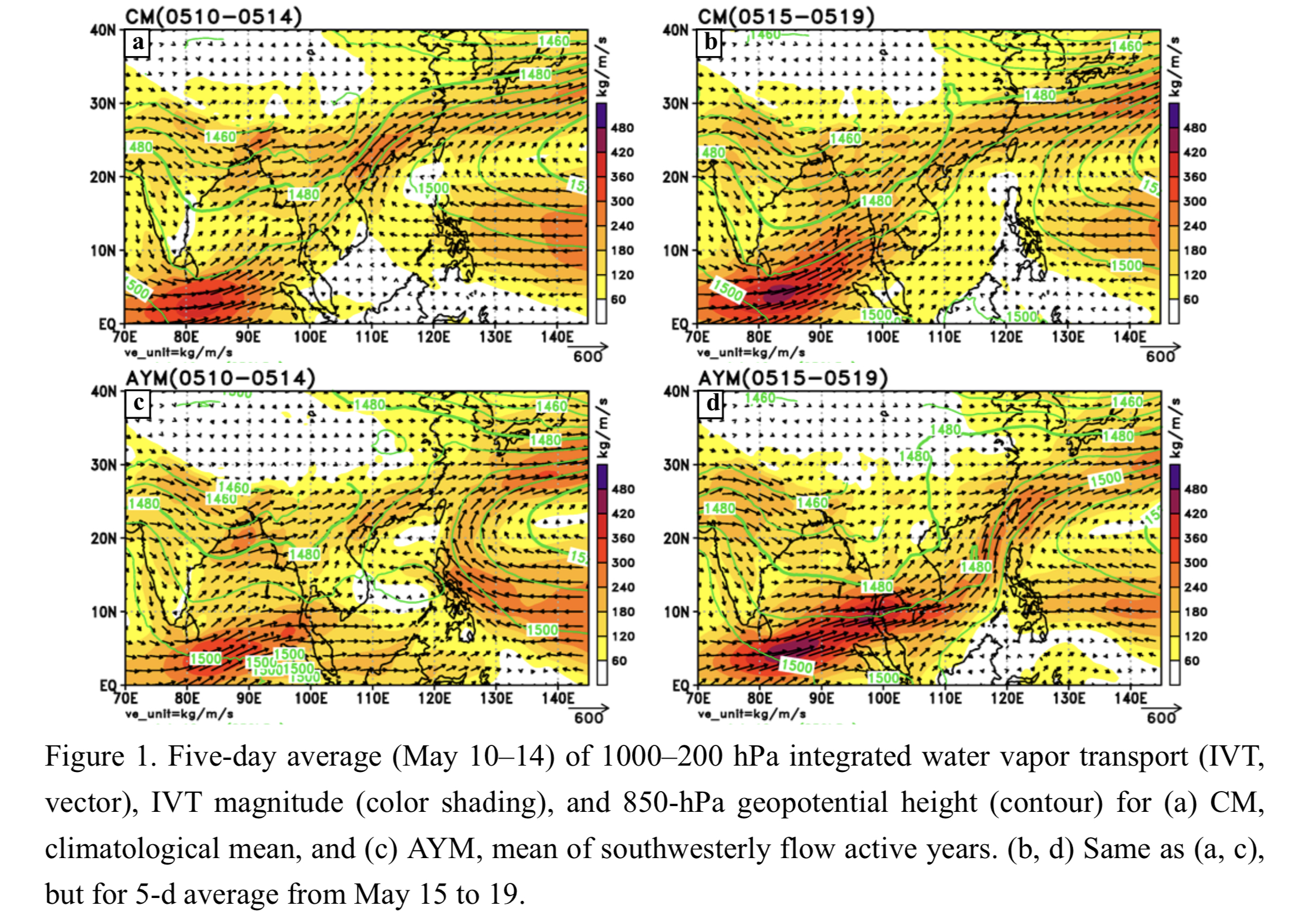
Chien, F.-C., Y.-C. Chiu, and C.-H. Tsou, 2021: A Climatological study of southwesterly flows and heavy precipitation in Taiwan during Mei-yu seasons from 1979 to 2018. J. Meteor. Soc. Japan, 99, 913-931.
https://doi.org/10.2151/jmsj.2021-044
Graphical Abstract
Plain Language Summary: During active years of southwesterly flow events, the Pacific high weakens and moisture is transported from the South China Sea to the Taiwan area in the early mei-yu season. The moisture-laden air results in a large equivalent potential temperature gradient to the north of Taiwan, favoring the formation of mei-yu fronts and low pressure systems. The pressure gradient thus increases and southwesterly flows develop. More moisture is transported toward Taiwan, resulting in heavy rainfall as well as a further increase of equivalent potential temperature.
Highlights:
- In southwesterly flow active years, the Pacific high weakens and moisture is transported to Taiwan from the Bay of Bengal and from the south of the Pacific high in the early mei-yu season.
- A positive feedback of moisture transport and southwesterly flow produces more fronts, stronger southwesterly flows, and heavier rainfall during the mei-yu season.
- The meridional component of vertically integrated water vapor transport (IVT) over the South China Sea and the Philippines in the early mei-yu season can be used to predict the occurrence of southwesterly flows and heavy rain for the entire mei-yu season.
Review Article
Kikuchi (2021)
Kikuchi, K., 2021: The Boreal summer intraseasonal oscillation: A review. J. Meteor. Soc. Japan, 99, 933-972.
https://doi.org/10.2151/jmsj.2021-045
Graphical Abstract
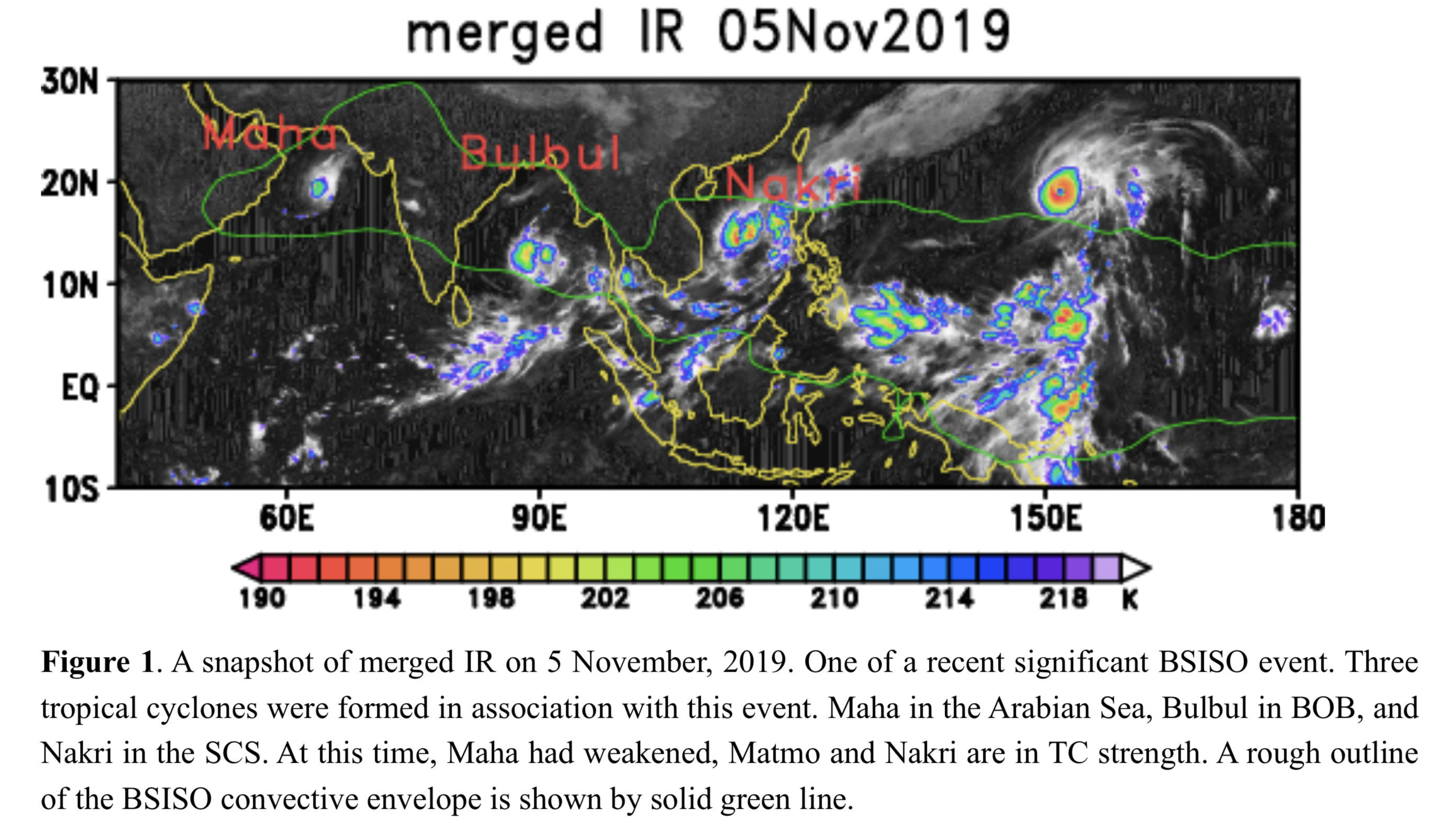
Plain Language Summary: The tropical intraseasonal oscillation (ISO) is one of the most pronounced atmospheric variability in the tropics. The ISO is characterized by a slowly eastward moving convective envelope along the equator from the Indian Ocean to the western Pacific that tends to recur with an interval of 30-90 days. Within the envelope, a variety of organized mesoscale convective systems develop. Although the ISO is pronounced throughout the year, it exhibits a significant seasonal cycle. The ISO during boreal winter, often referred to as the Madden-Julian oscillation, displays the simple eastward propagating feature mentioned above. In contrast, the ISO during boreal summer, referred to here as the boreal summer ISO (BSISO), displays more complicated propagation features: in addition to the eastward propagation, northward propagation of the convective envelope over the Northern Indian Ocean and the western North Pacific is pronounced. It exerts a strong influence on a broad range of tropical weather and climate phenomena such as tropical cyclogenesis, monsoon onset and active/break cycles, among others. There are many review articles on the MJO, whereas there are few, if any, review articles on the BSISO to the author’s knowledge. This paper attempts to provide an up-to-date review on some of the fundamental aspects of the BSISO from the viewpoint of observation, theory, and modeling.
Highlights:
- This paper provides an up-to-date review on some of the fundamental aspects of the BSISO from the viewpoint of observation, theory, and modeling.
- Observational aspects of the BSISO are described in a consistent manner based on the BSISO index of the bimodal ISO index (Kikuchi et al., 2012; Kikuchi 2020).
Article: Special Edition on DYAMOND: The DYnamics of the Atmospheric general circulation Modeled On Non-hydrostatic Domains
Shibuya et al. (2021)
Shibuya, R., M. Nakano, C. Kodama, T. Nasuno, K. Kikuchi, M. Satoh, H. Miura, and T. Miyakawa, 2021: Prediction skill of the boreal summer intra-seasonal oscillation in global non-hydrostatic atmospheric model simulations with explicit cloud microphysics. J. Meteor. Soc. Japan, 99, 973-992.
Special Edition on DYAMOND: The DYnamics of the Atmospheric general circulation Modeled On Non-hydrostatic Domains
https://doi.org/10.2151/jmsj.2021-046
Graphical Abstract
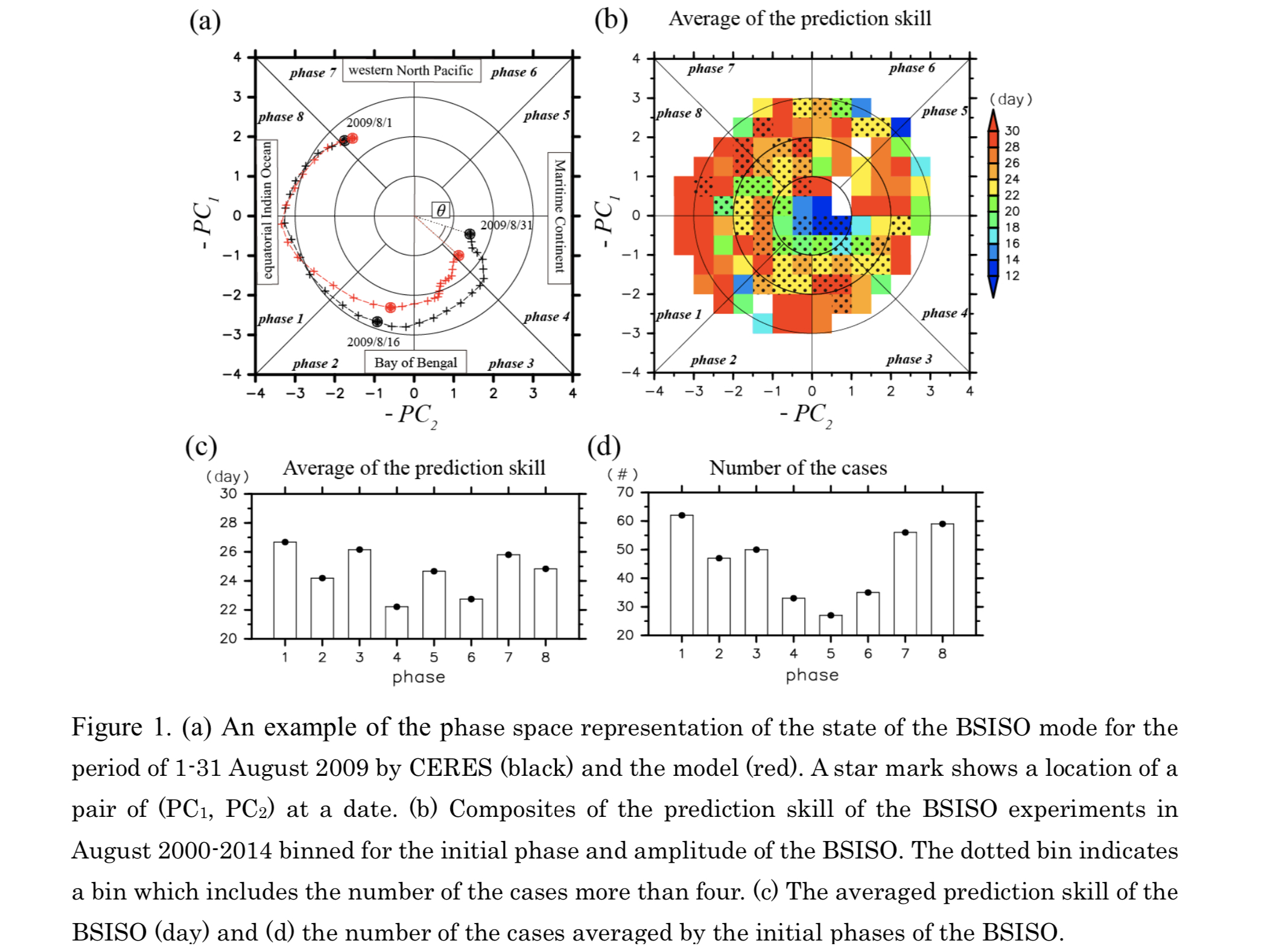
Plain Language Summary: This study assessed a prediction skill of the Boreal Summer Intra-Seasonal Oscillation (BSISO) mode using one-month simulations by a global non-hydrostatic atmospheric model. It was found that the model showed an BSISO prediction skill of approximately 24 days, while the prediction skill tended to be higher (~2 days) when the BSISO events began in the initial phases where a major convective center was located over the Philippine Sea.
Highlights:
- The initial phase-dependency of the prediction skill was associated with a stagnant behavior of the convective cells over the Philippines sea in the model.
- Based on a regression coefficient analysis, the stagnation of the propagation over the Philippines could be attributed to biases of the background monsoonal circulation in the model.
Notes and Correspondence
Sato & Kusaka (2021)
Sato, T., and H. Kusaka, 2021: Statistical intercomparison of similarity metrics in sea level pressure pattern classification. J. Meteor. Soc. Japan, 99, 993-1001.
https://doi.org/10.2151/jmsj.2021-047
Graphical Abstract
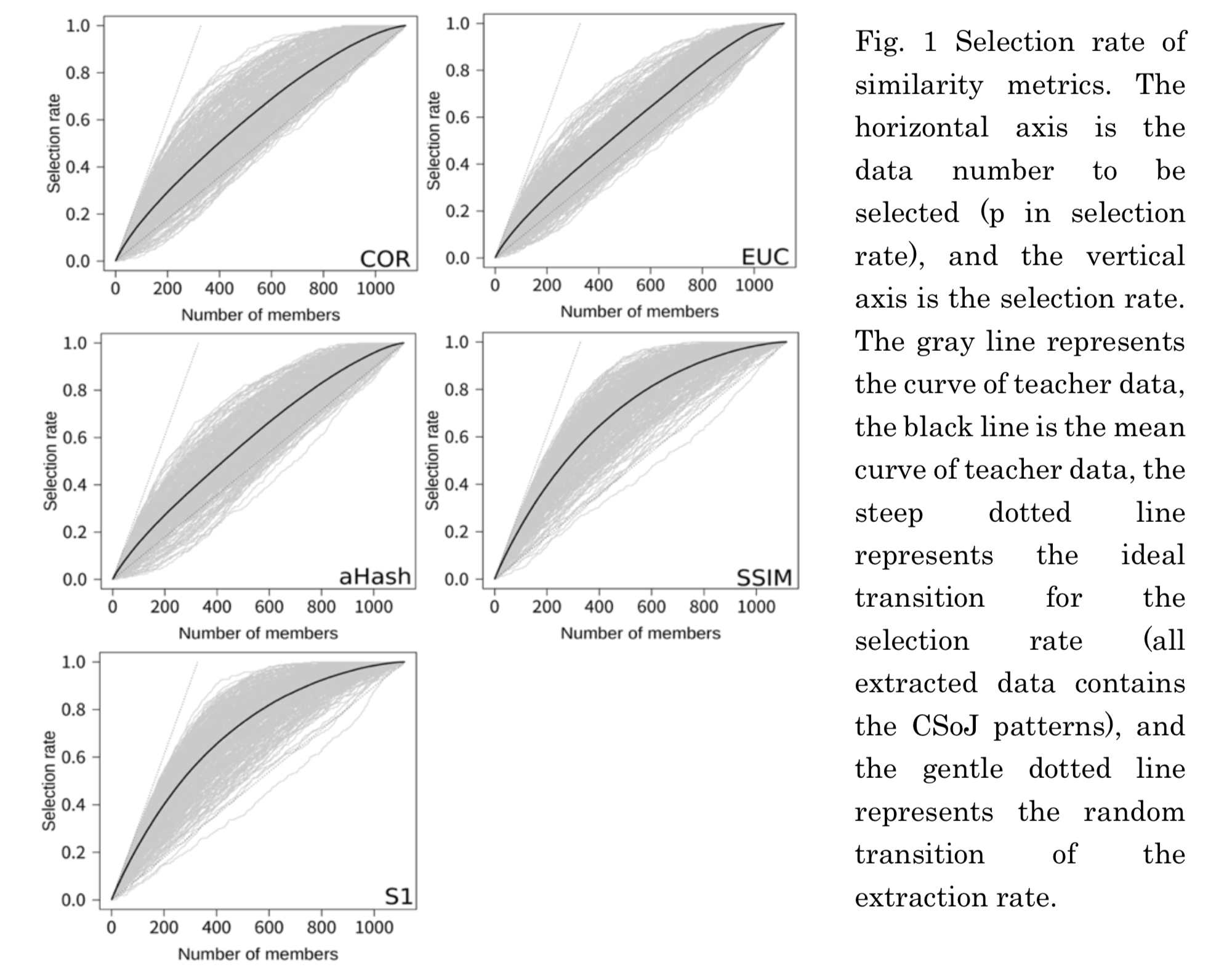
Plain Language Summary: We compare the accuracy of five representative similarity metrics in extracting sea level pressure (SLP) patterns for accurate weather chart classification. We use a large amount of teacher data to statistically evaluate the accuracy of each metric. The evaluation results reveal that S1 and SSIM have the highest accuracy in terms of both average and maximum scores. Their accuracy does not change even when non-ideal data are used as the teacher data.
Highlights:
- The accuracy of five representative similarity metrics is compared in extracting sea level pressure (SLP) patterns using a large amount of teacher data.
- S1-score and SSIM have the highest accuracy and their accuracy does not change even when non- ideal teacher data are used.
- This study can serve as a reference for identifying the most useful similarity metric for the classification of SLP patterns, especially when using non-ideal teacher data.
Article: Special Edition on Global Precipitation Measurement (GPM): 5th Anniversary
Komatsu et al. (2021)
Komatsu, K. K., Y. Iijima, Y. Kaneko, and D. Oyunbaatar, 2021: Validation of GSMaP products for a heavy rainfall event over complex terrain in Mongolia captured by the GPM core observatory. J. Meteor. Soc. Japan, 99, 1003-1022.
Special Edition on Global Precipitation Measurement (GPM): 5th Anniversary
https://doi.org/10.2151/jmsj.2021-048
Graphical Abstract
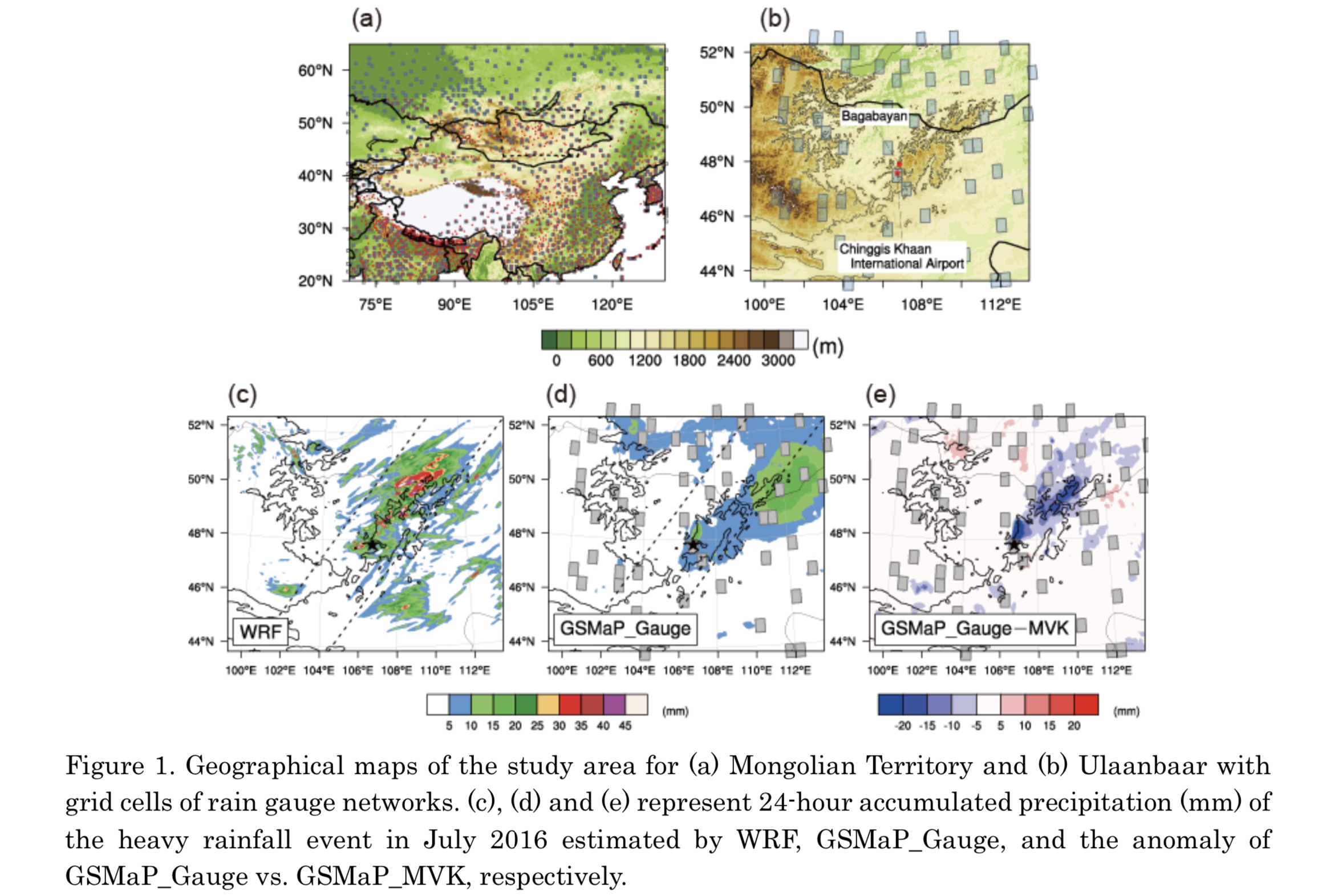
Plain Language Summary:Detailed comparisons with rainfall products by Global Satellite Mapping of Precipitation (GSMaP) were conducted using summer precipitation over Mongolia and a heavy rainfall event near Ulaanbaatar. The measurement by the core-satellite of the Global Precipitation Measurement mission (GPM) and the regional atmospheric modeling also cooperated the comparison for the rainfall event. As a result, the gauge-calibrated GSMaP effectively moderates the enormous error of the ungauged ones. However, the gauge-calibrated GSMaP over mountainous areas may be affected by a potential underestimation of gauge analysis due to the missing localized precipitation occurring in the significant gaps of the routine observation network.
Highlights:
- For national scale precipitation, the use of rain gauge calibration can effectively correct the tendency of satellite-only GSMaP products to overestimate precipitation.
- As for the case study, the GSMaP_Gauge may overcorrect rainfall over a mountain region with a far less surface observation station.
- As Mongolia has a complex terrain with a sparse observation network, the uncertainty of rain-gauge-based analysis resulting from the sparse network is likely to limit the accuracy of satellite-based precipitation estimates.
Article
Wu et al. (2021)
Wu, Y.-J., Y.-C. Liou, Y.-C. Lo, S.-L. Tai, S.-F. Chang, and J. Sun, 2021: Precipitation processes of a thunderstorm occurred on 19 August 2014 in northern Taiwan documented by using a high resolution 4DVar data assimilation system. J. Meteor. Soc. Japan, 99, 1023-1044.
https://doi.org/10.2151/jmsj.2021-049
Graphical Abstract
Plain Language Summary: The evolution of a heavy rainfall event occurred on 19 August 2014 in northern Taiwan is investigated with observed data and analyses from a newly-developed 4DVar data assimilation system named IBM_VDRAS. This event possesses different precipitating processes and track from those frequently observed in that region. The kinematic, thermodynamic, and microphysical fields of the convective cells are analyzed in details to explain the mechanisms which help to maintain the structure of the convective system and lead to heavy precipitation.
Highlights:
- The mechanisms leading to this event and its maintenance involve the interaction samong sea breeze, cold air outflow, cell merging, and terrain. A correct description of the interactions among these factors in a numerical model is a key to the improvement of the forecast.
- Sensitivity experiments of quantitative precipitation forecast (QPF) show that the terrains prevent the location of major rainfall from shifting outside of Taipei Basin.
- By assimilating surface data, the model can better predict the position of the rainfall.
Article: Special Edition on Global Precipitation Measurement (GPM): 5th Anniversary
Barreyat et al. (2021)
Barreyat, M., P. Chambon, J.-F. Mahfouf, G. Faure, and Y. Ikuta, 2021: A 1D Bayesian inversion applied to GPM Microwave Imager observations: Sensitivity studies. J. Meteor. Soc. Japan, 99, 1045-1070.
Special Edition on Global Precipitation Measurement (GPM): 5th Anniversary
https://doi.org/10.2151/jmsj.2021-050
Graphical Abstract
Plain Language Summary: The assimilation of cloudy and rainy microwave observations is under investigation at Météo- France with a method called ’1D-Bay+3D/4D-Var’. This method consists of two steps: (i) a Bayesian inversion of microwave observations and (ii) the assimilation of the retrieved relative humidity profiles in a 3D/4D-Var framework. In this paper, two estimators for the Bayesian inversion are used: either a weighted average (WA) or the maximum likelihood (ML) of a kernel density function. Sensitivity studies over the first step of the method are conducted for different degrees of freedom: the observation error, the channel selection and the scattering properties of frozen hydrometeors in the observation operator. Observations over a two-month period of the Global Precipitation Measurement (GPM) Microwave Imager (GMI) on-board the GPM-Core satellite and forecasts of the convective scale model Application of Research to Operations at Mesoscale (AROME) have been chosen to conduct these studies.
Highlights:
- Low observational errors tend to be associated with the retrieved profiles with the highest consistency with the observations.
- The validity of the retrieved profiles varies vertically with the set of channels used.
- The radiative properties of hydrometeors used in the radiative transfer simulations have a strong influence on the retrieved atmospheric profiles.
- The ML estimator provide retrievals which do not depend on the observation error but which are less constrained than the WA estimator when only few frequencies are considered in the inversion.
Article
Song et al. (2021)
Song, J., P. J. Klotzbach, and Y. Duan, 2021: Recent weakening of the interannual relationship between ENSO Modoki and boreal summer tropical cyclone frequency over the western North Pacific. J. Meteor. Soc. Japan, 99, 1071-1088.
https://doi.org/10.2151/jmsj.2021-051
Graphical Abstract
Plain Language Summary: Early studies reported that there was a significant relationship between the summertime ENSO Modoki and the simultaneous tropical cyclone (TC) frequency over the western North Pacific. However, this study show that the impact of ENSO Modoki on WNP TC formation has experienced decadal changes during the past few decades. The correlation between the ENSO Modoki index and WNP TC frequency is weak during 1975–1989, becomes strong and significant during 1990–2004, and becomes weak again during 2005–2019. This change results from the different ENSO Modoki sea surface temperature patterns among the aforementioned three sub-periods. The typical tripolar feature is only observed in 1990–2004, whereas it is not obvious in other two sub-periods.
Highlights:
- The relationship between ENSO Modoki and WNP TC frequency exhibits a decadal change in the past decades.
- The typical tripolar feature of sea surface temperature anomalies modulated by ENSO Modoki is only observed in 1990–2004, whereas a coupling pattern of ENSO Modoki and Pacific Meridional Mode is represented in 1975–1989 and 2005–2019.
Article
Sekiyama (2021)
Sekiyama, T. T., 2021: Sekiyama, T. T. and M. Kajino, 2021: Performance of a 250-m grid Eulerian dispersion simulation evaluated at two coastal monitoring stations in the vicinity of the Fukushima Daiichi Nuclear Power Plant. J. Meteor. Soc. Japan, 99, 1089-1098.
https://doi.org/10.2151/jmsj.2021-052
Graphical Abstract
Plain Language Summary: A super-high-resolution Eulerian dispersion model is sometimes defeated by a lower-resolution model in the vicinity of emission sources; in that case, a plume augmentation (max pooling) process is effective for the higher-resolution model to improve the statistical scores.
Highlights:
- We examined the performance of Eulerian dispersion models in the vicinity of a pollutant source (3.2 and 17.5 km distant) comparing 250-m and 3-km grid simulations.
- A disadvantage of Eulerian dispersion models is expected to be the artificial numerical diffusion near emission sources, but occasionally the artificial diffusion decreases the undetected error rate.
- Plume augmentation is advantageous to super-high-resolution models to improve statistical scores, which is beneficial for environmental emergency response systems.
Article: Special Edition on Global Precipitation Measurement (GPM): 5th Anniversary
Nakamura et al. (2021)
Nakamura, K., Y. Kaneko, K. Nakagawa, and H. Hanado, 2021: Radiowave scattering characteristics of melting layer measured by a dual Ka-band radar system. J. Meteor. Soc. Japan, 99, 1099-1114.
Special Edition on Global Precipitation Measurement (GPM): 5th Anniversary
https://doi.org/10.2151/jmsj.2021-053
Graphical Abstract
Plain Language Summary: Specific attenuation and equivalent radar reflectivity in a melting layer were measured using a dual Ka-band radar system. When the two radars are arranged to face each other and a precipitation system comes between the two radars, they observe the system from opposite directions. The radar echoes suffer from rain attenuation, which appears symmetrically in both radar echo profiles. By differentiating measured radar reflectivity with range, the specific attenuation (k) can be estimated. After obtaining the specific attenuation, the equivalent radar reflectivity (Ze) is estimated. Melting layer observations were conducted on a slope of Mt. Zao, Japan. The relationship between k and Ze showed interesting characteristic which appears in a loop-shape on a k-Ze diagram. A simple theoretical study explained this characteristic.
Highlights:
- Ka-band radiowave scattering characteristics in a melting layer was investigated using a dual Ka- band radar system.
- Specific attenuation (k) and equivalent radar reflectivity (Ze) were measured simultaneously.
- A loop-shape in the k-Ze diagram appeared for melting layer.
- The loop-shape was found to be due to permittivity and size change with Mie scattering effect.
Notes and Correspondence: Special Edition on Years of the Maritime Continent (YMC)
Yoneyama et al. (2021)
Yoneyama, K., M. Fujita, A. Seiki, R. Shirooka, S. Yokoi, E. O. Cayanan, C. O. Iglesia, and O. C. Cabrera, 2021: Evaluation of LMS6 and RS41 radiosonde humidity data obtained during YMC-Boreal Summer Monsoon study in 2018 and 2020. J. Meteor. Soc. Japan, 99, 1115-1125.
Special Edition on Years of the Maritime Continent (YMC)
https://doi.org/10.2151/jmsj.2021-054
Graphical Abstract
Plain Language Summary: Quality control of radiosonde humidity data was performed for the data obtained in the international field campaign called the Years of the Maritime Continent (YMC) - Boreal Summer Monsoon study in 2018. This was done based on the intercomparison between two radiosonde types. We also used precipitable water vapor data derived from Global Navigation Satellite System signals for assessment. In addition, we proposed a method to determine whether our correction procedures can be applied to other data or not.
Highlights:
- Intercomparison between the Lockheed Martin LMS6 and Vaisala RS41-SGP radiosonde data obtained in Laoag, Philippines in July - August 2018 as well as precipitable water vapor comparison with that derived from GNSS-signal demonstrated that LMS6 data were drier than that of RS41 only during daytime clear sky condition.
- We developed a look-up table, which adjusts LMS6 relative humidity values to that of RS41.
- Comparison of specific humidity at the surface and averaged over 300m in the boundary layer can be used to judge whether the same look-up table can be applied to other LMS6 data or not.
Article
Kodera et al. (2021)
Kodera, K., N. Eguchi, R. Ueyama, B. M. Funatsu, M. Gaetani, and C. M. Taylor, 2021: The impact of tropical tropopause cooling on Sahelian extreme deep convection. J. Meteor. Soc. Japan, 99, 1127-1139.
https://doi.org/10.2151/jmsj.2021-055
Graphical Abstract
Plain Language Summary: There has been a recent increase in heavy precipitation over Sahel in West Africa following decades of severe drought. This study shows that West Africa exhibited a cooling trend in the tropical lower stratosphere and tropopause layer since the 1980s, combined with a warming in the troposphere. These temperature changes destabilized the atmosphere and induced extreme deep convection over the Sahel where penetrating convection is frequent. In contrast, tropospheric warming suppressed the shallower convection over the neighboring Guinea Coast. This feature is similar to that which might result from increased greenhouse gas levels.
Highlights:
- Increasing trend in surface precipitation over Sahel contrasts a decreasing trend over Guinea Coast in West Africa.
- Precipitation increase over Sahel is due to an increase in extreme deep convection penetrating the tropical tropopause layer (TTL).
- Recent decadal change in convective activity occurred in association with a cooling (warming) in the tropical stratosphere (troposphere) indicative of a destabilization of the TTL.
JMSJ, 2021, Vol. 99, No. 5 (October)
Article
Nguyen et al. (2021)
Nguyen, T. H., K. Ishijima, S. Sugawara, and F. Hasebe, (2021): Application of a nudge general circulation model to the interpretation of the mean age of air derived from stratospheric samples in the tropics. J. Meteor. Soc. Japan, 99, 1149-1167.
https://doi.org/10.2151/jmsj.2021-056
Graphical Abstract
Plain Language Summary: The age of air is a transport characteristic of the stratospheric general circulation. Vertical profile of the age of air estimated from cryogenic air samples taken over Biak, Indonesia is investigated by applying the boundary impulse evolving response (BIER) method and Lagrangian backward trajectories to the transport field simulated by a general circulation model nudged to reanalysis.
Highlights:
- The profile of CO2 age is reproduced reasonably well by the Lagrangian method, whereas the BIER method overestimates the CO2 age above 25 km altitude possibly due to high diffusivity in the transport model.
- SF6 age is only reproducible in the lower stratosphere, and far exceeds the estimates from the Lagrangian method above 25 km altitude due to mesospheric SF6 loss.
Article
Uda et al. (2021)
Uda, T., T. Sakajo, M. Inatsu, and K. Koga, 2021: Identification of atmospheric blocking with morphological type by topological flow data analysis. J. Meteor. Soc. Japan, 99, 1169−1183.
https://doi.org/10.2151/jmsj.2021-057
Graphical Abstract
Plain Language Summary: We propose an algorithm detecting atmospheric blockings by extracting topological features of geo-potential height data at 500 hPa. The method is based on Topological Flow Data Analysis (TFDA), providing a unique symbolic representation (COT representation) and a discrete graph structure (Reeb graph) to every structurally stable Hamiltonian vector field. The algorithm objectively detects not only the period of blocking events but also the morphological types such as an Omega shape and a dipole pattern.
Highlights:
- An objective algorithm of Topological Flow Data Analysis, detecting atmospheric blockings from a dataset of the geo-potential height at 500 hPa, is proposed.
- The algorithm extracts all characteristic isopleth patterns in terms of topology, which are converted into discrete expressions in terms of COT representations and Reeb graphs.
- The detected blocking events and their morphological types agree with subjective judgements made by synopticians, while the algorithm requires fewer parameters than conventional methods.
Article
Si et al. (2021)
Si, D., Y. Ding, and D. Jiang, 2021: A low-frequency downstream development process leading to the outbreak of a mega-cold wave event in East Asia. J. Meteor. Soc. Japan, 99, 1185-1200.
https://doi.org/10.2151/jmsj.2021-058
Graphical Abstract
Plain Language Summary: An unprecedented cold wave swept through most parts of East Asia in January 2016, leading to record–breaking low temperatures and widespread snowfall in several regions. Our analysis indicated that this East Asian cold wave was triggered by a low-frequency downstream development process in the Northern Hemisphere from late 2015 to early 2016.
Highlights:
- In late 2015, a severe Atlantic storm entered the Arctic Circle, transported enormous warm and moist air masses, which led to an extraordinary Arctic warming event in late 2015.
- The Arctic warming event resulted in a distinct Arctic dipole pattern and an inverted omega–shaped circulation pattern (IOCP) over the Siberia–North Pacific region in early–mid–January 2016.
- The IOCP distinctly modulated the meridional circulation cell along the East Asia–Siberia regions, which intensified the Siberian high, eventually induced the outbreak of a mega-cold wave in East Asia on 21–25 January 2016.
Article: Special Edition on Global Precipitation Measurement (GPM): 5th Anniversary
Aonashi et al. (2021)
Aonashi K., T. Tashima, T. Kubota, and K. Okamoto, 2021: Introduction of a mixed lognormal probability distribution function and a new displacement correction method for precipitation to the ensemble-based variational assimilation of the all-sky microwave imager brightness temperatures. J. Meteor. Soc. Japan, 99, 1201-1230.
Special Edition on Global Precipitation Measurement (GPM): 5th Anniversary
https://doi.org/10.2151/jmsj.2021-059
Graphical Abstract
Plain Language Summary:
The brightness temperatures (TBs) obtained from the satellite microwave imager (MWI) provide global information about water substances. To achieve improved assimilation of all-sky MWI TBs into a cloud-resolving model (CRM), this study introduced a mixed lognormal distribution for the precipitation probability distribution function (PDF) model and a new displacement correction method using PDF pseudo-regimes for precipitation to an ensemble-based variational assimilation scheme.
Highlights:
- The mixed lognormal PDF strengthened the precipitation analysis of heavy-rain areas.
- The pseudo-regimes reduced the precipitation displacement error of the analysis.
- The assimilation of TBs improved the CRM forecasts for precipitation distribution up to 12 h and the typhoon position and central surface pressure for >24 h.
Article: Special Edition on Global Precipitation Measurement (GPM): 5th Anniversary
Hirose et al. (2021)
Hirose, M., S. Shige, T. Kubota, F. A. Furuzawa, H. Minda, and H. Masunaga, 2021: Refinement of surface precipitation estimates for the Dual-frequency Precipitation Radar on the GPM Core Observatory using near-nadir measurements. J. Meteor. Soc. Japan, 99, 1231-1252.
Special Edition on Global Precipitation Measurement (GPM): 5th Anniversary
https://doi.org/10.2151/jmsj.2021-060
Graphical Abstract
Plain Language Summary: This study attempts to improve surface precipitation estimates from GPM Core Observatory Dual-Frequency Precipitation Radar (DPR). We updated the low-level precipitation rate profiles (LPPs) using an a priori near-nadir database. The angle-bin difference in the detectability of shallow storms was examined to estimate the effect of missing shallow storms. We constructed a priori lookup tables constrained by the clutter-free bottom level and spatially averaged shallow precipitation fractions for the shallow precipitation deficiency (SPD) correction. Overall, these two corrections increase precipitation by 8% over land and 11% over ocean. These corrections mitigate approximately half of the incidence angle dependency over land and reduce the discrepancies from other global precipitation datasets.
Highlights:
- GPM DPR KuPR Version 06A data contain precipitation anomalies of −7% over land and −2% over ocean.
- The LPP correction increases precipitation, in particular, at high altitudes and at middle and high latitudes. The LPP correction results in a 5% global increase in precipitation.
- The SPD correction enhances precipitation by 6%. The impact reaches 50% over specific low-rainfall oceans in the sub-tropics and at high latitudes.
- The difference of KuPR precipitation compared to satellite-gauge blended products is reduced from ‒17% to ‒9%.
Article: Special Edition on Global Precipitation Measurement (GPM): 5th Anniversary
Awaka et al. (2021)
Awaka, J., M. Le, S. Brodzik, T. Kubota, T. Masaki, V. Chandrasekar, and T. Iguchi, 2021: Development of precipitation type classification algorithms for a full scan mode of GPM Dual-Frequency Precipitation Radar. J. Meteor. Soc. Japan, 99, 1253-1270.
Special Edition on Global Precipitation Measurement (GPM): 5th Anniversary
https://doi.org/10.2151/jmsj.2021-061
Graphical Abstract
Plain Language Summary: The Global Precipitation Measurement (GPM) Dual-Frequency (DF) Precipitation Radar (DPR) has operated in full scan (FS) mode in both the Ku-band and Ka-band since May 2018. For the first time in the DPR level 2 (L2) version V06X experimental algorithms, the DF processing has been made on the 245 km wide full swath data. In previous versions up to V06A, the DF processing is limited to the 125 km wide inner swath data only. This paper describes the V06X precipitation type classification algorithm that detects bright-band (BB) and classifies precipitation as stratiform, convective, and other.
Highlights:
-
The Global Precipitation Measurement (GPM) Dual-Frequency (DF) Precipitation Radar (DPR) has operated in full scan (FS) mode in both the Ku-band and Ka-band since May 2018. For the first time in the DPR level 2 (L2) version V06X experimental algorithms, the DF processing has been made on the 245 km wide full swath data. In previous versions up to V06A, the DF processing is limited to the 125 km wide inner swath data only. This paper describes the V06X precipitation type classification algorithm that detects bright-band (BB) and classifies precipitation as stratiform, convective, and other.
Article: Special Edition on DYAMOND: The DYnamics of the Atmospheric general circulation Modeled On Non-hydrostatic Domains
Heim et al. (2021)
Heim, C., L. Hentgen, N. Ban, and C. Schär, 2021: Inter-model variability in convection- resolving simulations of subtropical marine low clouds. J. Meteor. Soc. Japan, 99, 1271-1295.
Special Edition on DYAMOND: The DYnamics of the Atmospheric general circulation Modeled On Non-hydrostatic Domains
https://doi.org/10.2151/jmsj.2021-062.
Graphical Abstract
Plain Language Summary: We analyse the set of 40-day-long kilometre-resolution global atmospheric simulations of the DYAMOND model intercomparison project over the South-East Atlantic to study how this new family of models simulate subtropical marine low clouds. Such clouds represent a critical uncertainty in climate-change projections. The simulations produce low cloud fields that look in general realistic in comparison to satellite images, but there are considerable inter-model differences. Detailed analyses show that the relevant dynamical and physical processes of the marine boundary layer are consistently represented by the analysed models, indicating that there is a potential to improve the simulated low cloud cover through model calibration.
Highlights:
- Most models realistically simulate the low cloud field and the sharp gradients in atmospheric fields across the inversion but underestimate the albedo.
- All models overestimate outgoing longwave radiation due to underestimated free-tropospheric humidity.
- The average depth of the MBL differs considerably among the analysed models partly due to different entrainment rates. In models with stronger entrainment, the MBL grows deeper along the trade winds, leading to a higher average MBL depth. These models also tend to simulate more vigorous MBL dynamics, an increased surface latent heat flux, and an enhanced low cloud cover.
- Sensitivity experiments with the limited-area model COSMO for horizontal grid spacings between 12 km and 500 m indicate that the sensitivity with respect to resolution decreases for grid spacing below 4km. Such resolutions are thus attractive for climate studies.
Article
Yamada et al. (2021)
Yamada, H., K. Ito, K. Tsuboki, T. Shinoda, T. Ohigashi, M. Yamaguchi, T. Nakazawa, N. Nagahama, and K. Shimizu, 2021: The double warm-core structure of Typhoon Lan (2017) as observed through the first Japanese eyewall-penetrating aircraft reconnaissance. J. Meteor. Soc. Japan, 99, 1297-1327.
https://doi.org/10.2151/jmsj.2021-063
Graphical Abstract
Plain Language Summary: Eyewall-penetrating upper-tropospheric aircraft reconnaissance was carried out for Typhoon Lan (2017). This was the first case of a Japanese research group observing the inner core of an intense typhoon using dropsondes. We captured a double warm-core structure persisted in an environment with a strengthening vertical wind shear. Based on analyses of thermodynamics, we hypothesize the contribution of a high enthalpy air transported from the eye boundary layer into the upper warm core via the eyewall for the continuous eye warming.
Highlights:
- The two warm cores show a difference in the equivalent potential temperature (θe) of more than 10 K, suggesting different air origins.
- The thermodynamic pathway of high-θe air into the upper warm core from the eye boundary layer was characterized by temperatures almost fitted to a single moist adiabatic line.
- This study demonstrates the significance of eye-penetrating upper-tropospheric reconnaissance for understanding thermodynamic processes related to typhoon intensity.
Article
Hioki and Tsuboki (2021)
Hioki, T., and K. Tsuboki, 2021: Trajectory Analyses on the warm core development and pressure falls of a developing typhoon as simulated by a cloud-resolving model. J. Meteor. Soc. Japan, 99, 1329-1350.
https://doi.org/10.2151/jmsj.2021-064
Graphical Abstract
Plain Language Summary: The central pressure fall of a typhoon is associated with the development of the warm core in the eye and mass divergence of the eye. The purpose of this study is to examine (i) the origins and paths of the air comprising the warm core, and (ii) the paths followed by air leaving the eye in the troposphere. We performed trajectory analyses based on a high-resolution (2-km) numerical simulation of a developing typhoon Wipha (2007) using the cloud-resolving model CReSS.
Highlights:
- The results of backward trajectories calculated from the eye show that the air parcels comprising the upper-level warm core originated from the lower troposphere and the lower stratosphere.
- The results of forward trajectories calculated from the eye that air parcels leave the eye through the eyewall throughout the troposphere, particularly at heights below 2 km and between 9 and 12 km, which ultimately results in a central pressure fall.
Article: Special Edition on Extreme Rainfall Events in 2017 and 2018
Ohara et al. (2021)
Ohara, R., T. Iwasaki, and T. Yamazaki, 2021: Impacts of evaporative cooling from raindrops on the frontal heavy rainfall formation over western Japan on 5-8 July 2018. J. Meteor. Soc. Japan, 99, 1351-1369.
Special Edition on Extreme Rainfall Events in 2017 and 2018
https://doi.org/10.2151/jmsj.2021-065
Graphical Abstract
Plain Language Summary: This study examines impacts of evaporative cooling in the heavy rainfall event in early July 2018 to deepen our knowledge about when and how evaporative cooling affects Baiu frontal precipitation systems. Results of sensitivity experiments reveal that the raindrop evaporation maintains the position of the heavy front-induced precipitation by suppressing the northward retreat of the frontal surface.
Highlights:
- AheavyprecipitationareaextendingfromtheChugokuregiontocentralKinki(seedottedellipses in Fig. 1a) is displaced northward by more than 100 km when raindrop evaporation was turned off (confirmed by comparing Figs. 1a, c with Fig. 1b, d).
- The precipitation mentioned above is not mainly formed by updrafts along mountain slopes, but by updrafts above a frontal surface at a potential temperature of 300 K.
- Methods of the cold airmass analysis are used to examine impacts of evaporative cooling on the position of the frontal surface by quantifying the cold air below the frontal surface.
- The exclusion of raindrop evaporation in the numerical experiment considerably reduces the cold airmass amounts over western Japan and results in the northward retreat of the frontal surface.
Article: Special Edition on DYAMOND: The DYnamics of the Atmospheric general circulation Modeled On Non-hydrostatic Domains
Inoue et al. (2021)
Inoue, T., K. Rajendran, M. Satoh, and H. Miura, 2021: On the semidiurnal variation in surface rainfall rate over the tropics in a global cloud-resolving model simulation and satellite observations. J. Meteor. Soc. Japan, 99, 1371-1388.
Special Edition on DYAMOND: The DYnamics of the Atmospheric general circulation Modeled On Non-hydrostatic Domains
https://doi.org/10.2151/jmsj.2021-066
Graphical Abstract
Plain Language Summary: A 3.5-km mesh Non-hydrostatic Icosahedral Atmospheric Model (NICAM) for 26–31 December 2006 simulates the dual peak semidiurnal variation in surface rainfall rate over the tropics. We confirmed this semidiurnal variation of surface rainfall rate from 17-year winter precipitation climatology of Tropical Rainfall Measuring Mission (TRMM) TMI (TRMM Microwave Imager), Precipitation Radar (PR), and the same 6-day data of Global Satellite Mapping of Precipitation (GSMaP), as well as infrared data from geostationary satellites.
Highlights:
- Over southern Africa and the Amazon, the NICAM simulation captures the primary peak in the afternoon and the secondary peak in the early morning, at similar times to those captured by TRMM data.
- In the PR observation, the primary peak of rainfall is mainly due to convective rain, whereas the secondary peak is due to stratiform rain. In the NICAM simulation, if a simple method is used for classification of convective/stratiform rain, convective rain is dominant all day long and the rainfall rate is generally higher than the PR observation.
- In the NICAM simulation, the relative magnitudes of the two peaks are not represented well, and the contribution of the stratiform rain is underestimated.
JMSJ, 2021, Vol. 99, No. 6 (December)
Article
Ikeda & Kusaka (2021)
Ikeda T., and H. Kusaka, 2021: Development of models for predicting the number of patients with heatstroke on the next day considering heat acclimatization. J. Meteor. Soc. Japan, 99, 1395-1412.
https://doi.org/10.2151/jmsj.2021-067
Graphical Abstract
Plain Language Summary: Some models for predicting the number of ambulance transport due to heatstroke cause underestimation in early summer. This study’s model reduces underestimation in early summer, using the number of days since June 1 and the number of ambulance transport due to heatstroke on the previous day.
Highlights:
- We developed models for prediction the number of ambulance transport due to heatstroke using different combination of explanatory variables and modeling methods.
- The best model was developed by combining six explanatory variables (temperature, relative humidity, wind speed, solar radiation, the number of days since June 1, and the number of ambulance transport due to heatstroke on the previous day) and the generalized additive model.
- The contribution of changing the modeling methods to the prediction accuracy was smaller than that of changing the explanatory variables.
Article
Wang et al. (2021)
Wang, C., L. Wu, H. Zhao, Q. Liu, and J. Wang, 2021: An abrupt slowdown of late season tropical cyclone over the western North Pacific in the early 1980s. J. Meteor. Soc. Japan, 99, 1413-1422.
https://doi.org/10.2151/jmsj.2021-068
Graphical Abstract
Plain Language Summary: Tropical cyclones (TCs) induced disasters are largely controlled by their translation speed, which was previously supposed to be linked to their surrounding steering flows. Here we find that, for the western North Pacific, variations in translation speed are not consistent with that of individual TCs controlled by steering flow. In contrast, changes in the subtropical TC track ratio play a foremost role due to the much higher translation speed of TCs influencing the subtropical region than that of TCs traveling across the tropical region. Thus, changes in TC translation speed should be examined in regions where the magnitude of translation speed is generally uniform distributed. The result highlights the important role of TC track in the global/regional change of TC translation speed and is important to understand the current change in TC translation speed.
Highlights:
- Basin-wide tropical cyclone (TC) translation speed over the western North Pacific (WNP) in the late season (October-December) experienced an abrupt decrease in the early 1980s.
- The decrease in the subtropical TC track ratio contributes to the slowdown in TC motion over the WNP due to the much higher TC translation speed in the subtropical WNP.
- The decrease in the subtropical TC track ratio mainly attributes to an anti-cyclonic circulation over the WNP that appears to be driven by the Atlantic Multi-decadal Oscillation.
Article: Special Edition on Global Precipitation Measurement (GPM): 5th Anniversary
Arias and Chandrasekar (2021)
Arias, I., and V. Chandrasekar, 2021: Cross validation of the network of ground-based radar with GPM during the Remote sensing of Electrification, Lightning, And Mesoscale/microscale Processes with Adaptive Ground Observations (RELAMPAGO) field campaign. J. Meteor. Soc. Japan, 99,
Special Edition on Global Precipitation Measurement (GPM): 5th Anniversary,
https://doi.org/10.2151/jmsj.2021-069.
Early Online Release
Graphical Abstract
Plain Language Summary: We present an intercomparison between three C-band radars deployed during RELAMPAGO with the spaceborne radar KuPR on board GPM. We also compare these C- band radars with each other. Each radar is compared pairwise with one another, including KuPR. Evaluating the network consistency is the unique aspect of this paper, in addition to the comparison with the space borne radar. The attenuation correction coefficient was tuned to the local microphysical environment to achieve improved accuracy of reflectivity.
Highlights:
- The bias between KuPR and the C-band radars reduces when the locally tuned attenuation correction algorithm is used.
- The residual bias between three of the radars is used to have a sense of the bias consistency in the network.
- The bias between each pair of radars is recalculated using the information from the other radars in the network.
- The consistency of the biases in the network is brought to less than 0.2 dB after recomputing the bias for each pair of radar.
Article: Special Edition on DYAMOND: The DYnamics of the Atmospheric general circulation Modeled On Non-hydrostatic Domains
Roh et al. (2021)
Roh, W., M. Satoh, and C. Hohenegger, 2021: Intercomparison of cloud properties in DYAMOND simulations over the Atlantic Ocean. J. Meteor. Soc. Japan, 99, 1439-1451.
Special Edition on DYAMOND: The DYnamics of the Atmospheric general circulation Modeled On Non-hydrostatic Domains
https://doi.org/10.2151/jmsj.2021-070.
Graphical Abstract
Plain Language Summary: We intercompared the cloud properties of the seven atmospheric general circulation models with a grid spacing of less than about 5 km over the Atlantic Ocean. The domain averaged outgoing longwave radiation was found to be similar across the models. The vertical structure of cloud water, cloud ice and cloud fraction exhibited large variations across models.
Highlights:
- The domain averaged outgoing long-wave radiation (OLR) is relatively similar across the models, but the net shortwave radiation at the top of the atmosphere (NSR) shows large differences among the models.
- The models capture the triple modes of cloud systems corresponding to shallow, congestus, and high clouds, even though their partition in these three categories is strongly model dependent.
- The averaged mixing ratio of ice clouds consistently increased with finer grid spacing in three models, but such a consistent signal is not apparent for the mixing ratio of liquid clouds for shallow and congestus clouds.
Article: Special Edition on Typhoons in 2018–2019
Wada (2021)
Wada, A., 2021: Roles of oceanic mesoscale eddy in rapid weakening of Typhoons Trami and Kong-Rey in 2018 simulated with a 2-km-mesh atmosphere-wave-ocean coupled model. J. Meteor. Soc. Japan, 99, 1453-1482.
Special Edition on Typhoons in 2018–2019
https://doi.org/10.2151/jmsj.2021-071
Graphical Abstract
Plain Language Summary: To understand the role of a cold-core eddy in the intensity change of Typhoons Trami and Kong-Rey (2018), numerical simulations were performed with a 2-km-mesh nonhydrostatic atmosphere model and an atmospheric-wave-ocean coupled model. The ocean’s role in the simulated rapid weakening of two typhoons was related to the low upper-ocean heat content caused by typhoon-induced sea surface cooling. The reductions in downward motion in the center of two typhoons and the associated adiabatic heating were closely related to the weakening. The difference of ocean’s role between the two typhoons were discussed.
Highlights:
- The difference of the role of mesoscale cold eddy in the simulations of Typhoons Trami and Kong-Rey (2018) was discussed.
- Embedding an artificial cold-core eddy of which magnitude is not based on in situ observations into the oceanic initial condition helped promote sea surface cooling induced by Trami and suppress the overdevelopment.
- A reasonable simulated track of Kong-Rey would have spent more time traveling over the Trami-induced sea surface cooling area, which enhanced the weakening.
Article: Special Edition on DYAMOND: The DYnamics of the Atmospheric general circulation Modeled On Non-hydrostatic Domains
Bao and Stevens (2021)
Bao, J. and B. Stevens, 2021: The elements of the thermodynamic structure of the tropical atmosphere. J. Meteor. Soc. Japan, 99,
Special Edition on Typhoons in 2018–2019,
https://doi.org/10.2151/jmsj.2021-072
Early Online Release
Graphical Abstract
Plain Language Summary: The two foundations of the tropical atmosphere are that the horizontal temperature in the free troposphere is homogeneous, and the vertical structure follows a moist-adiabatic lapse rate. This study uses simulations from global storm-resolving models to investigate the accuracy of these ideas. Our results show that horizontally the density temperature appears to be homogeneous, but only in the mid- and lower troposphere. Vertically, the tropical atmosphere in saturated convective regions tends to be isentropic (condensed water remaining in the updraft) below the freezing level and pseudo-adiabatic (condensed water/rain falling immediately upon formation) above. However, the tropical mean temperature is substantially colder than that in saturated convective regions because of the impact of entrainment, a process that the saturated air mixes with dry environment, in the lower troposphere.
Highlights:
- Horizontally the density temperature appears to be homogeneous, but only in the mid- and lower troposphere (between 400 hPa and 800 hPa). Therefore, water vapor plays an important role in the horizontal absolute temperature distribution.
- The tropical atmosphere in saturated convective regions tends to adopt a thermal structure that is isentropic below the zero-degree isotherm and pseudo-adiabatic above.
- The tropical mean temperature is substantially colder, and is set by the bulk of convection which is affected by entrainment in the lower troposphere.
Article
Endo et al. (2021)
Endo, H., A. Kitoh, R. Mizuta, and T. Ose, 2021: Different future changes between early and late summer monsoon precipitation in East Asia. J. Meteor. Soc. Japan, 99,
https://doi.org/10.2151/jmsj.2021-073.
Early Online Release
Graphical Abstract
Plain Language Summary: Future changes in East Asian summer monsoon (EASM) precipitation and the associated atmospheric circulation changes are investigated with a 60-km-mesh atmospheric general circulation model (AGCM). The results highlight a distinct difference between early and late summer in future changes of EASM precipitation (Fig. 1a). Sensitivity experiments with the AGCM reveal that the precipitation changes in early summer are dominated by the effects of sea surface temperature (SST) warming, resulting in an intensification and a southward shift of the Baiu rainband (Figs. 1d and 1f), whereas the influence of land warming and successive large SST warming in the extratropics is evident in late summer (Figs 1c and 1e).
Highlights:
- The Meiyu–Baiu rainband is projected to strengthen, with its eastern part (i.e., the Baiu rainband) shifted southward relative to its present-day position in June, while there is a lack of consensus on the projection of the rainband in July.
- The competition between the opposing factors makes the signal of the Meiyu–Baiu rainband response smaller in July than in June, and thus there tends to be a larger spread among simulations regarding the future tendency of the rainband in July.
Article
Yang et al. (2021)
Yang, W.-T., S.-M. Fu, J.-H. Sun, F. Zheng, J. Wei, and Z. Ma, 2021: Comparative evaluation of the performances of TRMM-3B42 and CMORPH precipitation estimates over Thailand. J. Meteor. Soc. Japan, 99,
https://doi.org/10.2151/jmsj.2021-074.
Early Online Release
Graphical Abstract
Plain Language Summary: Thailand plays an important role in ensuring the global food security. To understand precipitation features over Thailand is of great importance to agriculture in Thailand. This study conducted a detailed comparative evaluation between the TRMM-3B42v7 and CMORPH precipitation products, and showed the relative performances quantitatively. We found that, overall, the TRMM-3B42v7 displayed a better performance than that of CMORPH.
Highlights:
- Based on a total of 35 factors, TRMM-3B42v7 and CMORPH precipitation products were compared quantitatively for the entire Thailand and its five regions.
- The TRMM-3B42v7 displayed an oveall better performance than that of CMORPH.
- In terms of daily precipitation intensity and monthly variation of precipitation, Central Thailand was the only region where CMORPH displayed a similar performance to TRMM-3B42v7.
Article
Takamura & Khatri (2021)
Takamura, T. and P. Khatri, 2021: Uncertainties in radiation measurement using a rotating shadow- band spectroradiometer. J. Meteor. Soc. Japan, 99,
https://doi.org/10.2151/jmsj.2021-075.
Early Online Release
Graphical Abstract
Plain Language Summary: A spectral radiometer with a shadow-band system can give two components simultaneously, direct (spDNI) and diffuse (spDHI), of solar radiation by using a combination of different band positions. These components estimated by a current analysis method have some errors due to imperfect correction of radiation shadowed by band. We discuss the errors using typical aerosol models under a realistic operational condition of the instrument. As a fundamental system error, it is clear that the valid range of the band angle is less than 72 deg within 2 % error in correction for a common setting of the instrument. And errors of optical depth ( τ ) as well as spDNI and spDHI are estimated, depending on their aerosol optical thickness (AOD).
Highlights:
- A correction coefficient Cfwd for forward scattering shadowed by band is introduced and discussed under realistic atmospheric and instrumental conditions.
- Errors on spDNI, spDHI and τ are estimated as a function of AOD using typical four aerosol models, Troposphere, Rural, Urban and Ocean. For example, one of simulated results shows that each error of these has about 5 %, -4 % and -5 %, respectively with AOD of 0.5 for Oceanic aerosol type.
Article
Ikuta et al. (2021)
Ikuta, Y., T. Fujita, Y. Ota, and Y. Honda, 2021: Variational data assimilation system for operational regional models at Japan Meteorological Agency. J. Meteor. Soc. Japan, 99,
https://doi.org/10.2151/jmsj.2021-076
Early Online Release
Graphical Abstract
Plain Language Summary: The regional data assimilation system at the Japan Meteorological Agency employs a variational data assimilation system on the basis of the non-hydrostatic model ASUCA (named ASUCA-Var). As a system for operational use, ASUCA-Var is designed for sustainable development. This paper reviews configurations, workflow of operational systems, and performances of ASUCA-Var.
Highlights:
- The control variables of ASUCA-Var include soil variables and basic atmospheric variables.
- The background-error covariance is defined every three hours for land and sea grid, taking into account diurnal variation and differences in error structure on land and sea.
- The cost function is designed to be a perfect quadratic form, and the basic field update method in the optimization process allows the nonlinearity of observation and model operators to be incorporated into the solution of optimization problem in the incremental four-dimensional variational method.
- Variational quality control and variational bias correction are introduced for advanced observation handling within the variational system.
Article
Steppeler et al. (2021)
Steppeler, J., J. Li, F. Fang, and J. Zhu, 2021: The o2o3 Local Galerkin method using a differentiable flux representation. J. Meteor. Soc. Japan, 99,
https://doi.org/10.2151/jmsj.2021-077
Early Online Release
Graphical Abstract
Plain Language Summary: Local Galerkin methods, in particular the spectral elements (SE) solve the difficulty in classic Galekin methods for applying to multiprocessor system and have been found to be scalable up to millions of processors. The present study investigates improvements of SE under the name o2o3 which substitutes the irregular Gauss-Lobatto grid in SE by a regular collocation grid to compute Galerkin integrals with the potential to improve the computational efficiency and simplify the physical parameterization.
Highlights:
- A correction coefficient 𝐶fwd for forward scattering shadowed by band is introduced and discussed under realistic atmospheric and instrumental conditions.
- Errors on spDNI, spDHI and t are estimated as a function of AOD using typical four aerosol models, Troposphere, Rural, Urban and Ocean. For example, one of simulated results shows that each error of these has about 5 %, -4 % and -5 %, respectively with AOD of 0.5 for Oceanic aerosol type.


